Showing 23059 items matching "creek"
-
 Eltham District Historical Society Inc
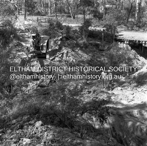
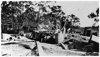
Negative - Photograph, J.A. McDonald, Henley Road at Watsons Creek, Mar. 1961
Henley Road at Watsons Creek Looking easterly along new alignment, 22 March 1961 C. Browns Excavator Contractor Wolf Cr PellingRecord of various Shire of Eltham infrastructure works undertaken during the period of 1952-1962 involving bridge and road reconstruction projects, sometimes with Eltham Shire Council Project Reference numbers quoted. It was during this period that a number of significant improvements were made to roads and new bridges constructed within the shire that remain in place as of present day (2022). In many situations, the photos provide a tangible visible record of infrastructure that existed throughout the early days of the Shire. The album was put together by or under the direction of the Shire Engineer, J.A. McDonald.infrastructure, shire of eltham, 1961-03, bend of islands, cr. charis pelling, henley road, henley road bridge, kangaroo ground, oxley bridge, watsons creek, w.e. wolf, bridge construction, road construction -
 Greensborough Historical Society
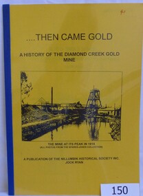
Book, Then came gold: a history of the Diamond Creek Gold Mine: by Jock Ryan, 2001_
The Diamond Creek Gold Mine was active from the 1860s and by 1912 had 12 known shafts. This book outlines ownership and contains anecdotes about the mine.A short history of the Diamond Creek Gold MineBook, 9 pages. Black and white illustrations and maps. Yellow front page with clear plastic cover.John Mackey in pencil inside front cover.diamond creek, john l ryan, jock ryan, diamond creek gold mine, gold discoveries victoria -
 Stawell Historical Society Inc
Photograph, Stawell Wheat Site Construction beside the main rail line behind the Pleasant Creek Training Centre and Woollen Mills -- Demolished 1945-1946
Building Stawell Wheat Site situated beside the main rail line behind the Pleasant Creek Training Centre and Woollen Mills. Demolished 1945-1946stawell -
 Stawell Historical Society Inc
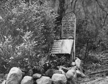
Photograph, Miss Agnes Folkes' Grave -- close to camping ground near Stony Creek in Halls Gap
Halls Gap. A Lonely Childs Grave (Agnes Folkes) close to camping Ground beside walk Stony Creek. The child's parents had a Sawmill nearby.halls gap -
 Old Colonists' Association of Ballarat Inc.
Document - Miner's Right, Miner's RIght Issued to John Paterson at Pleasant Creek No 169, 16/12/1859
Pleasant Creek was the original game for Stawell, Victoria. John Paterson is possibly the same John Paterson who was involved at the Eureka Stockade. (http://eurekapedia.org/John_Paterson )Miners' Right made out to John Paterson.miner's right, john paterson, pleasant creek -
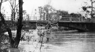
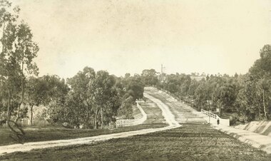
 Eltham District Historical Society Inc
Negative - Photograph, Construction of the new concrete bridge over the Diamond Creek on Main Road, Eltham, c.May 1926
Construction of the new concrete bridge over the Diamond Creek on Main Road, Eltham, c.May 1926. Viewed from northern approach looking south east towards Eltham Park (Eltham Lower Park), showing the power lines that used to run in front of the park. The original long suspension bridge over the Diamond Creek on Main Road at Eltham collapsed during flooding of the Diamond Creek on October 13 and 14, 1923. The original bridge was built around 1840 for the coach road when Cobb & Co.'s coach was the only conveyance between Eltham and Melbourne. Widespread damage was done in Melbourne and surrounding areas by floods resulting from the overflow of the Yarra at many points along its banks. A temporary bridge rigged up was severely damaged by the flooding of the creek and was closed to vehicular traffic in April 1924. A new concrete bridge was constructed to replace it and by May 1926 all the concrete piles and abutments had been completed. The bridge was finally completed and opened for traffic in September 1926, almost three years after it initially collapsed.This photo forms part of a collection of photographs gathered by the Shire of Eltham for their centenary project book,"Pioneers and Painters: 100 years of the Shire of Eltham" by Alan Marshall (1971). The collection of over 500 images is held in partnership between Eltham District Historical Society and Yarra Plenty Regional Library (Eltham Library) and is now formally known as the 'The Shire of Eltham Pioneers Photograph Collection.' It is significant in being the first community sourced collection representing the places and people of the Shire's first one hundred years.Digital image 4 x 5 inch B&W Negshire of eltham pioneers photograph collection, bridge, bridge construction, cement mixer, diamond creek (creek), eltham, eltham lower park, eltham south, main road bridge -
 Stawell Historical Society Inc
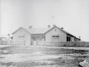
Photograph, Telegraph Office Pleasant Creek Stawell 1866
Telegraph Office Pleasant Creek Stawell. Part of a collection of Photographs by Mr. O.G. Armstrong as commissioned by the Shire of Stawell for the Inter-colonial and Paris Exhibition in Melbourne in 1866. The first post was office was erected at Commercial Street, Pleasant Creek in the goldfields, in June 1858, by J Harding and was a portable one. In October 1860 the first permanent Telegraph Office was erected by Cormick and Irvine for £329. In the same month the Post Office was removed from Commercial St in the Goldfields to the rear of the Telegraph office in Stawell. In February 1862 Edmond Johnson was appointed manager of Electrical Telegraph, Collector of Imposts and acting Postmaster. This building was later used as a private dwelling. It is situated in Lesley Street at the rear of the Pleasant Creek Courthouse although the right-hand wing has been removed. stawell -
 Ringwood and District Historical Society
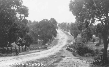
Photograph, Maroondah Highway East, Ringwood- 1870. Sandy Creek, now Ringwood Lake
3 photographs (2 large black and white, 2 small- 1 black and white, 1 sepia) Written on all photographs, "View at Ringwood" Typed below large photograph: "Main St looking east. Right hand side of gully now Ringwood Lake. Written on back of sepia print: "1870, Sandy Creek now Ringwood Lake" -
 Stawell Historical Society Inc
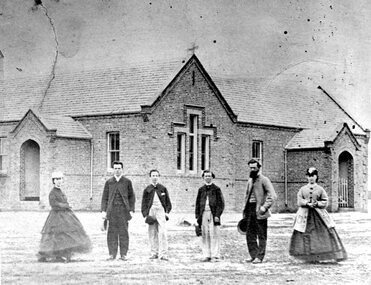
Photograph, Pleasant Creek School Students & Some Staff 1866
Staff and Pleasant Creek 502 Common School. Part of a collection of Photographs by Mr. O.G. Armstrong as commissioned by the Shire of Stawell for the Inter-colonial and Paris Exhibition in Melbourne in 1866. The education of children in the early years was at the hands of various denominations and attendance was not compulsory. So it was at Pleasant Creek, where prior to 1858, no real effort had been made by any of the nominations to establish schools. In 1864 the denominational system was abolished and school became known as the ‘common school’, such as pictured. stawell education -
 Falls Creek Historical Society
Flyer - Julian Brown 'Galleon' room advertisement
This item is from the private collection of George Shirling of Red Onion, Falls Creek. It is an early advertisement for rooms at the "Galleon" Ski Club. The "Galleon" was originally owned by Jim Willis. In 1958 Julian Brown took over the lease, managing it whilst building Arundel Lodge. After the winter of 1959, the "Galleon" was bought by Tom Greene and renamed Cooroona. George Shirling arrived in Falls Creek in 1962. He engaged Phil Nowell to build the original Koki Alpine Lodge which opened in 1965 with 14 beds. George operated the lodge with Michael “Baldy” Blackwell as manager. He also graduated in sport psychology in 1981 and was invited to become team psychologist for the Australian Winter Olympic team which went to Albertville, France, in 1992. He later owned the Red Onion Chalet. George credited the success of Koki to “Baldy” Blackwell. “Baldy” and Phil Nowell started the Trackers Mountain Lodge in partnership during the 1980s. In 1971 George sold Koki Lodge to Sigi Doerr. In 2024 the renamed Koki Alpine resort remains a highly popular destination in Falls Creek. George Shirling passed away on 27th February 2023. He had remained actively involved in Falls Creek and was generous with his time and knowledge, always an amazing supporter of The Falls Creek Museum and Falls Creek Village.This item is significant because it was an important feature of the Falls Creek Ski School Instructor uniform.A beige coloured flyer advertising room at the "Galleon" in Falls Creek. An explanatory sign is attached.On sign" ITEM No. 147 1958 Julian Brown, manager of the "Galleon", offer you rooms that are "never stuffy" and you can have "as many blankets as you like". This was Julian's first job at Falls Creek.george shirling, red onion, ski instructor badge, falls creek ski instructor -
 Eltham District Historical Society Inc
Negative - Photograph, Diamond Creek floodwater at Monash Bridge, Hurstbridge, Dec. 1934
The historic 1934 flood of the Diamond Creek and Yarra River following the storms of 29-30 November set the levels for future planning with respect to flood water rise.This photo forms part of a collection of photographs gathered by the Shire of Eltham for their centenary project book,"Pioneers and Painters: 100 years of the Shire of Eltham" by Alan Marshall (1971). The collection of over 500 images is held in partnership between Eltham District Historical Society and Yarra Plenty Regional Library (Eltham Library) and is now formally known as the 'The Shire of Eltham Pioneers Photograph Collection.' It is significant in being the first community sourced collection representing the places and people of the Shire's first one hundred years.Digital image 4 x 5 inch B&W Negshire of eltham pioneers photograph collection, hurstbridge, 1934 flood, floods, monash bridge, diamond creek (creek) -
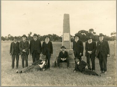 Stawell Historical Society Inc
Photograph, "Peace" Memorial on Halls Gap Road built 1919 at site of old Treasury Building Commercial Street Pleasant Creek c1922
Group of Gentlemen beside the Peace Memorial situated on Halls Gap Road built 1919 at site of old Treasury Building Commercial Street Pleasant Creek. C1922stawell -
 Stawell Historical Society Inc
Photograph, Pleasant Creek Court House with Stawell Histotical Society member Betty Collins seated with Stawell Historical Society Past President Margaret Mason satnding
Interior main hall of Pleasant Creek Court House. Stawell Historical Society member Betty Collins seated and Past President Margaret Mason standing with banner. stawell -
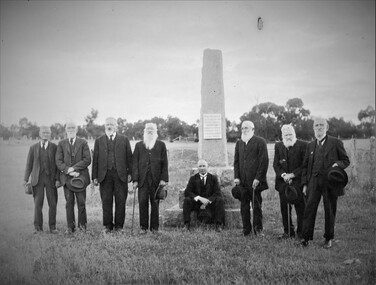 Stawell Historical Society Inc
Photograph, "Peace" Memorial on Halls Gap Road built 1919 at site of old Treasury Building Commercial Street Pleasant Creek c1922
Group of Gentlemen beside the Peace Memorial situated on Halls Gap Road built 1919 at site of old Treasury Building Commercial Street Pleasant Creek. C1922stawell -
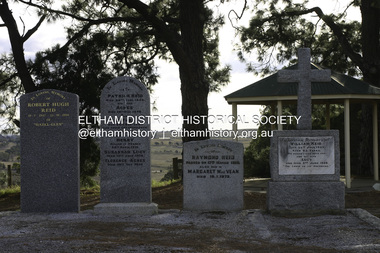 Eltham District Historical Society Inc
Photograph - Digital Photograph, Alan King, Reid family graves, Arthurs Creek Cemetery, 30 March 2008
The Arthurs Creek Cemetery was originally the private cemetery of pioneers Agnes and Patrick Reid. Published: Nillumbik Now and Then / Marguerite Marshall 2008; photographs Alan King with Marguerite Marshall.; p11 The Hazel Glen property, at Middle Hut Road, Arthurs Creek, which includes one of Victoria’s earliest pioneer buildings, was the forerunner to the Arthurs Creek and Doreen townships. At one time the Doreen Post Office and school were called Hazel Glen. The Hazel Glen State School No 945, before it was moved to its present site, stood on land to the south of Chapel Lane, which had been donated by Hazel Glen owner, William Reid. In May 1895 the post office was renamed Doreen to avoid confusion with the Reid’s address. The Arthurs Creek Cemetery was originally the private cemetery of Hazel Glen pioneers Agnes and Patrick Reid. The Reids with their eight children, arrived in Melbourne in April 1839. In 1844 Patrick Reid took over the licence to the Stewart Ponds run of 5120 acres (2072ha). Reid renamed it Hazel Glen, after Hazelden, the name of the Reid estate at Mearns in Renfrewshire, Scotland. Reid built a small cottage from local stone and hand-made bricks, with walls one yard (91 cm) thick, a flagstone floor and a shingle roof. Today two rooms and a store room survive as part of a larger house. Agnes died in 1847 aged 49, and was buried on a hill overlooking Hazel Glen, where it is said she had asked to be buried as it had been a favourite picnic spot.2 In 1858 Patrick died aged 74, and was buried near her. Their son William was to become Whittlesea Shire’s first president. From 1868 he was a Whittlesea Roads Board member, then a shire councillor until shortly before his death in 1923 aged 88. In 1865 the Reid’s burial area was no longer on their property, so it was declared a cemetery site. In 1867 it became the Linton Public Cemetery, being in the Linton Parish. However, to avoid confusion with Linton near Ballarat, the cemetery was renamed the Arthurs Creek Public Cemetery in 1926. Arthurs Creek was named after Henry Arthur, a pastoralist and public servant, who ran 1000 sheep lower down the Creek, from 1836 to 1841. It is believed he built his home at the end of today’s Challenger Street in Diamond Creek.This collection of almost 130 photos about places and people within the Shire of Nillumbik, an urban and rural municipality in Melbourne's north, contributes to an understanding of the history of the Shire. Published in 2008 immediately prior to the Black Saturday bushfires of February 7, 2009, it documents sites that were impacted, and in some cases destroyed by the fires. It includes photographs taken especially for the publication, creating a unique time capsule representing the Shire in the early 21st century. It remains the most recent comprehenesive publication devoted to the Shire's history connecting local residents to the past. agnes reid, arthurs creek cemetery, nillumbik now and then (marshall-king) collection, patrick reid, reid family -
 Eltham District Historical Society Inc
Negative - Photograph, Floodwaters, Diamond Creek, Eltham, 1934
The Diamond Creek in flood near the Main Road bridge at Eltham, Victoria. The Yarra also was in flood. In early December 1934 the "Greatest flood in the history of the Yarra" occured, according to The Argus newspaper. Bridges and houses were swept away with hundreds of people left homeless across the state. The historic 1934 flood of the Diamond Creek and Yarra River set the criteria for future planning with respect to flood water rise. Noted on reverse of print - Copied by Hugh Fisher, 82 Lygon St., BrunswickThis photo forms part of a collection of photographs gathered by the Shire of Eltham for their centenary project book,"Pioneers and Painters: 100 years of the Shire of Eltham" by Alan Marshall (1971). The collection of over 500 images is held in partnership between Eltham District Historical Society and Yarra Plenty Regional Library (Eltham Library) and is now formally known as the 'The Shire of Eltham Pioneers Photograph Collection.' It is significant in being the first community sourced collection representing the places and people of the Shire's first one hundred years.Digital image 4 x 5 inch B&W Neg (2 frames on one neg) Print 9 x 15.5 cmOn reverse of print - "Copied by Hugh Fisher, 82 Lygon St., Brunswick" (for Shire of Eltham)sepp, shire of eltham pioneers photograph collection, eltham, floods, 1934 flood, diamond creek (creek), floodwater -
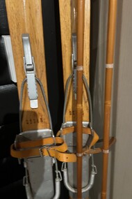 Falls Creek Historical Society
Equipment - Skis from the Four Seasons Lodge, Falls Creek
In 1948 Bob Hymans (1922-2007) built a small lodge on the corner of Falls Creek Road by the oversnow called Four Seasons or The Grand Coeur Annexe. Believed to be a wonderful host Bob also owned and operated Southern Cross and Grand Coeur. Grand Coeur unfortunately burnt down in 1961. These skis, now located in the Falls Creek Museum, were donated by Bob’s daughter Bridget. They hung in the main room of the Lodge for many years, never touching snow.These skis are significant because they were owned by Bob Hymans, a pioneer of Falls Creek, Victoria.A pair of wooden skis with bindings and poles.bob hymans, four seasons, grand coeur chalet -
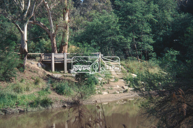 Eltham District Historical Society Inc
Slide - Photograph, Viewing platform near the confluence of Diamond Creek and Yarra River, c.Nov. 2001
In October 1996 the viewing platform was opened. It is situated near Lenister Farm on the Diamond Creek trail. It was a joint project involving Nillumbik Shire Council, Skill Seekers Inc., Department of Natural resources and Environment and Department of Employment, Education, Training and Youth Affairs. The platform was officially opened by Don Cordell Chairman of Commissioners. Part of a slide show presentation "A Trip Down the Diamond Creek" by Russell Yeoman to the Eltham District Historical Society meeting of 14 Nov. 200135mm colour positive transparency Mount - Black and Whiteconfluence, diamond creek, yarra river, viewing platform -
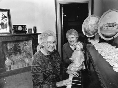 Stawell Historical Society Inc
Photograph, Pleasant Creek Court House with Stawell Historical Society President Margaret Mason at the Piano & Treasurer Mari Van Leeuwen with the doll 1989
Interior of Pleasant Creek Court House in Parlour. Stawell Historical Society President Margaret Mason Seated at the Piano. Treasurer Mari Van Leeuwen seated with doll. 1989stawell -
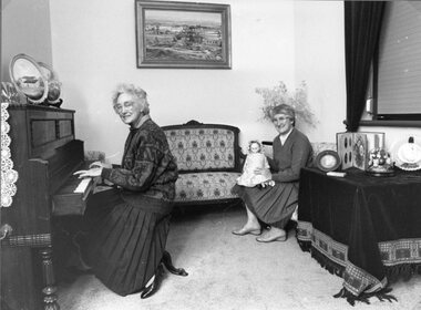 Stawell Historical Society Inc
Photograph, Pleasant Creek Court House with Stawell Historical Society President Margaret Mason at the Piano & Treasurer Mari Van Leeuwen with the doll 1989
Interior of Pleasant Creek Court House in Parlour. Stawell Historical Society President Margaret Mason Seated in front of the Piano. Treasurer Mari Van Leeuwen with doll. 1989stawell -
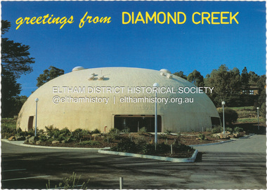 Eltham District Historical Society Inc
Postcard - Photograph, Nucolorvue Productions Pty Ltd, greetings from Diamond Creek, n.d
Diamond Creek Bini Shell Community venue Built in 1979 in Diamond Creek opposite the hotel using a construction method invented by Dante Bini. A net of flexible steel rods were laid on the building’s circular base, on the top of a fabric bladder. Concrete was poured onto the mesh and a sealed cover laid over the concrete making a sandwich of cover, bladder and mesh. Compressed air was pumped into the bladder and the sandwich slowly began to rise and become a massive self-supporting dome. The inflation of the dome attracted crowds of onlookers many from various technical schools, VIPs and the famous football doctor, Donald Cordner. An opening night dinner was held to celebrate the construction and the Diamond Creek Bini Shell was used as a community venue for over ten years including for the Town Fair. The Shell was closed for safety reasons after a Bini Shell in another State had chunks of concrete fall off the dome due to a construction fault. At the Diamond Creek Town Fair in 1991 the demolition of the Bini Shell was an item on the Town Fair’s program. Information: Kevin Patterson, Nillumbik Historical Societybini shell, diamond creek community centre, nu-color-vue, postcard -
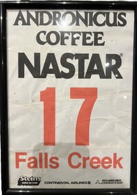 Falls Creek Historical Society
Memorabilia - NASTAR Racing Bib No. 17
National Standard Race (abbreviated NASTAR) is the world's largest recreational ski and snowboard race program which was founded in 1968 by SKI magazine. It uses a handicap system which allow skiers and boarders of all abilities to have a go at racing and compare their times to the best racers in the world. NASTAR courses are simple, open-gated slalom courses on mostly intermediate terrain, allowing skiers of all abilities and ages to experience racing. The NASTAR race course at Falls Creek is still the home of the Rossignol Children's Cup and the Cranky Charlie Cup each year, conditions permitting.This item is significant because it is linked to the NASTAR events held at Falls Creek throughout the 1980s.A paper number bib used by a participant in the NASTAR ski event at Falls Creek. It is primarily black and white, with the number and Falls Creek printed in red. It is in a frame under glass. It bears the names of major sponsors.ANDRONICUS COFFEE NASTAR 7 FALLS CREEK Steins World Ski Tours Continental Airlines Challenge Series DYNASTARnastar racing, falls creek race club -
 Eltham District Historical Society Inc
Albert Jones, Chute Street, Diamomnd Creek, c.1920
Reproduced in The Diamond Valley Story, Dianne H Edwards, The Shire of Diamond Valley 1979, p43 "1920s - the toiwnship now has some private phones. To the right at the single pole in Main Street is of Diamond Creek's street lamps. Rose's bakery is at the rear of the corner house. The baker's daughty, Fanny, married Charlie Wilson. Both attended Diamond Creek State School in the 1890s. The small square hgouse on the left-hand sid in Inglis Street was the home of the Kidd family. This house and the station are the only buildings in the photo still standing [1979]. Above and to the right of the Kidd hoime is the Diamond Creek Cool Stores, built in 1913 and now the site of the squash courts. The hills around Perversi Street are cleared and planted ith orchards. On the corner of Chute and Diamond Streets is the roof of the Lawrey sisters haberdashery shop. Photo: Spark/Jones Collection"Stamped in purple ink on reverse within border "A.J. SPARK COLLECTION PHOTOS 1900 - 1930 PHOTOGHRAPHER LATE ALBERT JONES DIAMOND VALLEY. TEL: 83-3561"a.j. spark collection, albert jones, chute street, diamond creek, j. mcritchie, royal mail hotel -
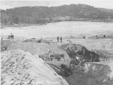 El Dorado Museum Association Inc.
Photograph (item) - Digital Image
Altering course of Reedy Creek, El Dorado. Cocks Pioneer Electric Gold & Tin Mine Company was formed in 1899. The company's first power station, located at the eastern end of the valley began operating with its 340 Kilowatt steam-powered generator. By 1909, from 2,500,000 cubic yards worked, reported recovery was 17,284 ounces of gold and 224 tons of tin ore. By 1909, Cocks Pioneer’s power plant had become inadequate and uneconomical. The barge was floated downstream about a mile, but lost time caused the operations to cease. Following testing, a new mine was established by diverting Reid's Creek at a cost of £25 000. Settling dams were built, one of which held 1,935,900 cubic feet. Sold earth banks, built against a wall of stringy bark saplings constructed and laced with vertical props, were built. In 1914, the company was reformed as Cock’s Pioneer Gold and Tin Mines NL, another power station was constructed at the western end of the township, near the junction of Clear and Reid's Creeks. From 6,800,000 cubic yards of material processed, the returns were 64,397 ounces of gold and 855 ton of tin. Cocks Pioneer mine then moved the barge downs stream and continued sluicing. In 1929 Cocks Pioneer Electric Gold and Tin Mining Company ceased operations due to a drop in values. Cock’s Pioneer Gold and Tin Mines NL carried on large-scale hydraulic sluicing operations until 1941. Handwritten across the front: 'Altering course of creek. Eldorado'mining, gold, tin, sluicing, reedy creek, cocks pioneer, el dorado, eldorado, men, horses -
 Bacchus Marsh & District Historical Society
Map, Lerderderg Gorge Road Goodmans Creek to Gisborne Road
The date of this map and its purpose has not been established. It was possibly produced to indicate landholders who were impacted by works along the Lerderderg Gorge Road. A single page paper map showing various blocks of land along the route of the Lerderderg Gorge Road near Bacchus Marsh from Goodmans Creek to the point where the road joins with Gisborne Road. The map is pasted into a bound volume containing 76 maps or plans in total. High resolution digital image stored on BMDHS computer network. bacchus marsh victoria maps, lerderderg gorge road bacchus marsh maps -
 Linton and District Historical Society Inc
Photograph, O'Beirne's Scouring works on Emu Creek, Linton 1904
Black and white copy of original photograph showing scouring works, a large shed on the right of photo, another shed in middle and two open sheds on the left. A Mount in the background with two live trees and 2 dead trees. The Emu creek runs along the bottom of the Mount at back of photo and does a right turn following the trees behind the large shed. emu creek, linton, pittong, 1904, business, farming, wool, sheep, o'beirne scouring works -
 Lake Bolac & District Historical Society
Colour photograph, Jan. 2011 Flood, Lake Bolac and Salt Creek
Jan. 2011 Flood. Debouchment from Lake Bolac into Salt Creek through the natural overflow (centre) and the channel (front left) dug in the 1920's. Photograph courtesy Bill Sharp.lake bolac, salt creek, flood, sharp. -
 Ringwood and District Historical Society
Photograph, Maroondah Highway East, Ringwood- 1900. Sandy Creek Bridge, Maroondah Hwy
3 photographs ( 2 large black and white, 1 small sepia)Written on all copies: "New Sandy Creek Bridge". Typed below large photograph: "Maroondah Highway Ringwood looking east. To right of bridge is now Ringwood Lake. Mount Dandenong Road turnoff to right at top of rise with antimony mine in background - 1900". -
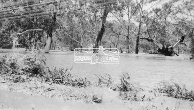
 Eltham District Historical Society Inc
Photograph, Fay Bridge, Diamond Creek in flood at the Bridge Street Bridge, Eltham, c.2004
View looking southeast from Alistair Knox Park (west). The Diamond Creek Trail footbridge is completely submerged. Significant flood events occurred Nov-Dec 2004 and Jan-Feb 2005.fay bridge collection, 2004, bridge street bridge, diamond creek (creek), floods, floodwater -
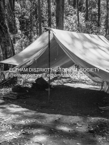 Eltham District Historical Society Inc
Photograph - Negative, Lewis Tulk, Possibly 6 Preston Salvation Army Scout Group at Dixons Creek, c.1980
Metal pole tent belonged to 6 Preston Salvation Army Scout group who used to camp in Dixons Creek Donated by Lewis Tulk, former Scout Area Training Commisioner for Leaders.scouts victoria, scout leader training, lewis tulk collection, yarra batman area, 6 preston salvation army scouts, dixons creek, scan - 120 format 6x4.5 negative