Showing 1234 items matching "crown land"
-
 Eltham District Historical Society Inc
Photograph - Digital Photograph, Alan King, Edendale Farm Homestead, 29 January 2008
Edendale Farm is Nillumbik Shire Council's environment centre situated in Gastons Road, Eltham between the railway and the Diamond Creek. The homestead on the property was built in 1896 and is of historical significance, being the subject of a Heritage Overlay under the Nillumbik Planning Scheme. The Edendale property was originally part of an extensive land purchase in 1852 from the Crown by pioneer Eltham farmer Henry Stooke. He initially purchased 51 acres and later expanded his holdings by purchasing another three adjacent Crown allotments extending northerly from Josiah Holloway's Little Eltham subdivision. Despite clearing the land, Stooke did not build on this property, choosing to live on his property "Rosehill" at Lower Plenty. In 1896 Thomas Cool, Club Manager of the Victoria Coffee Palace in Melbourne purchased 7 acres of the original Stooke land and built the house now known as Edendale. Cool did not farm the land, instead using it as a gentleman’s residence, retiring to Eltham at weekends. In 1918 he purchased an additional 7 acres but in 1919 he sold the property. Later owners included J.W. Cox, the Gaston family and D. Mummery. In the 1980s the Eltham Shire Council purchased the site for use as a Council depot, but this use did not proceed. Subsequently, it was used as the Council pound. The Edendale Farm Pet Education and Retention Centre was established in the summer of 1988/1989 and was set up to replace the existing dog kennels with a high standard pet retention centre. The design style of the building was established to compliment the features of the existing house. It was equipped with 10 retention pens, a veterinary room and a pet education area where school children and other interested parties learnt about pet care procedures. It was later developed into a community farm and was run by an advisory committee and in 2000 it became an Environment Centre. In early 2006 an advisory committee was established for the development of a master plan for future development at Edendale Farm. The committee included Russell Yeoman, a former long-time shire planner and founding member of the Eltham District Historical Society. At the time of filming the Master Plan and future for Edendale was about continuing to develop Edendale as a centre of environment learning and looking at expanding displays and school program, running a lot more of life-long learning and workshops around sustainable living. Covered under Heritage Overlay, Nillumbik Planning Scheme. Published: Nillumbik Now and Then / Marguerite Marshall 2008; photographs Alan King with Marguerite Marshall.; p101 A sharp turn from busy Wattletree Road by the railway line, brings a surprise. Only 1.4 km from Eltham’s centre, sheep feed, blissfully unaware of the hectic suburban activity so close by. At the entrance to the 5.6ha Edendale Farm is another surprise. A work of art that looks like huge tree trunks transformed into bowler and top-hatted men. The Fences Act 1968 by Tony Trembath with Mark Cain and John Doyle, 1996, is classified by the National Trust of Australia as having Regional Significance. The title refers to a government act on disputes between neighbors over the placement of fences and boundaries. This takes a ‘wry swipe’ at a community divided by trivial squabbles. It also celebrates making do with limited resources.1 Further along on the left, the office wall is decorated with a massive Eltham Copper Butterfly, designed by Robert Tickner and made by school children with used plastic bottles and other waste material. Nillumbik Council runs Edendale as an Environmental Education Centre, to help preserve and enhance the local environment. As early as 1988 the former Eltham Shire Council realised Edendale’s importance in meeting people’s needs, particularly of children, to enjoy farmland. The centre, with the Eltham North Reserve to the north - including remnant bushland and open parkland - makes up the major part of the public open space for this area. The council considers this area will become increasingly important to the local community for recreational use.2 Educational programs aim to encourage community involvement to ensure the long-term rehabilitation and protection of natural bushland areas. Edendale is used by people of all ages - from school children to adults - for environmental programs and workshops, as well as for recreation, to enjoy the domestic animals and to picnic. Edendale is also home to the Environmental Works staff who manage reserves and roadsides and support Nillumbik Friends environmental groups. The Friends propagate plants at the nursery, which grows indigenous plants and sells these to the public.3 The centre demonstrates the sustainable living the farm teaches, with features like solar hot water and drive lighting and for the fireplace, logs of recycled cardboard. Edendale has had a varied history as a dog pound and even as a retreat for Thomas Cool, Club Manager of the Victoria Coffee Palace in Melbourne. His single-storey weatherboard house built in 1896, which still stands, was grander than most homes in Eltham. Although such buildings were common in many other parts of Melbourne, Eltham’s poverty and remoteness did not encourage such construction. The Victorian rectangular-shaped house, with a corrugated iron roof and veranda, has elegant large rooms, leadlight windows, ceiling roses, two bay windows and ornately carved wooden fireplace surrounds. Cool bought seven acres (2.8ha) from pioneer Eltham farmer Henry Stooke’s 200 acre (81ha) farm, which he had bought from the Crown in 1852. In 1918 Cool bought an extra seven acres (2.8ha) but in 1919 sold the estate to farmer John Cox. In 1933 Cox sold Edendale to Mrs Elizabeth Gaston, after whom the road leading to the centre was named. The property was owned by several Gaston family members, who called it Edendale, then by a police constable, Douglas Mummery, until the Shire of Eltham bought it in 1970. Oddly Edendale was known as Mummery’s for almost 20 years, although Mummery owned it only for a short time.4 The shire used Edendale as a dog pound until amalgamation with other municipalities in 1996. The pound then moved to the Yan Yean Road, Plenty site, which had been used by the former Diamond Valley Shire Council. To the west and north the centre is bounded by Diamond Creek and on the east by the Melbourne-Hurstbridge railway line. Part of the Research creek forms the centre’s southern boundary.This collection of almost 130 photos about places and people within the Shire of Nillumbik, an urban and rural municipality in Melbourne's north, contributes to an understanding of the history of the Shire. Published in 2008 immediately prior to the Black Saturday bushfires of February 7, 2009, it documents sites that were impacted, and in some cases destroyed by the fires. It includes photographs taken especially for the publication, creating a unique time capsule representing the Shire in the early 21st century. It remains the most recent comprehenesive publication devoted to the Shire's history connecting local residents to the past. nillumbik now and then (marshall-king) collection, edendale farm -
 Eltham District Historical Society Inc
Photograph - Digital Photograph, Alan King, Heritage apple tree, 24 January 2008
... of the property on which the tree grows show that the land was a crown... of the property on which the tree grows show that the land was a crown ...This old apple tree situated beside the Plenty River Trail at Greensborough has been associated with Melbourne Founder John Batman. Known as Batman's Tree, this apple tree is on the bank of the Plenty River near Leischa Court, Greensborough. It is said that Melbourne Founder John Batman may have planted the tree and later signed his treaty here with the Aboriginal people. It still bears fruit and its recorded on the National Trust's Register of Significant Trees, as the oldest apple tree in Victoria. Published: Nillumbik Now and Then / Marguerite Marshall 2008; photographs Alan King with Marguerite Marshall.; p7 Was This John Batman's Tree? An apple tree on the bank of the Plenty River near Leischa Court, Greensborough, is believed to have belonged to Melbourne’s founder, John Batman. It could also stand where John Batman signed his famous treaty with the Aboriginal people.1 Known as Batman’s Tree, it still bears fruit and is recorded on the National Trust’s Register of Significant Trees, as the oldest apple tree in Victoria. It is ‘Believed to have been planted by either John Batman, (c1837) or Martin Batey (1841)’.2 In 1966 a Horticultural Adviser, Mr Rolfe, after extensive questioning of aged Greensborough residents, wrote: ‘it thus seems fairly certain that the old tree on the banks of the Plenty River is an original Batman apple tree’. Mr Rolfe said that the tree stood on a spot formerly called Wattle Bend: ‘one of the sites claimed to be where John Batman signed his famous treaty with the aboriginals. ‘My main source of information has been interviews with people who attended school in the Greensborough area from 70 to 80 years ago. Their parents were close to the days when Melbourne was founded so information passed on by word of mouth.’ Around 1920 the tree was struck by lightning and a concrete block was placed in the split. The concrete is inscribed with the date 1841 when the tree was thought to have been planted. Not everyone agrees with Mr Rolfe however. Former secretary of the Nillumbik Historical Society, Kevin Patterson, said there was no written evidence to support the claim. But he said the tree had been known to locals for decades as Batman’s Tree. In the 1920s a holiday resort in the area advertised: ‘Come to Greensborough and see John Batman’s tree’. Mr Patterson said it was thought that when Batman died in 1839 his land was sold and a Greensborough man Frederick Flintoff bought seedlings from his orchard for £1 each. This was the only one left.3 Mr Rolfe said: ‘If planted in 1837, or even a few years later, it undoubtedly is the oldest living apple tree in Victoria. Title records of the property on which the tree grows show that the land was a crown grant of F D Wickham in 1840. Mr Wickham was reputed to be a friend of John Batman. All the early settlers prior to the crown grants were squatters, by virtue of Batman’s treaty. This treaty was revoked by the then New South Wales Government, so it is likely that Wickham or an agent was in occupation before 1840. ‘According to Mrs Mavis Latham (John Batman – Great Australian Series, Oxford University Press) when Batman came to Port Phillip in 1835 he brought fruit trees with him. He failed to get a crown grant for his selection on Collins Street, which included 20 acres (eight ha) of orchard and cultivation. His residence became the Government Office and Melbourne grew from wild bushland in 1835 to a town of over 20,000 people by 1841. It is possible Batman visited Wickham and presented him with a tree.’ However a Flintoff descendant in 1933 said Frederick Flintoff ordered his bailiff Martin Batey to transplant the Batman Tree from the Spencer Street orchard to its present site as a memorial to his friend Batman.4 Mr Rolfe spoke to many people, including descendants of the Bateys and Flintoffs and pupils at the Greensborough Primary School. Many had gained their information from a ‘very highly respected’ head master Lewis Amiet at the Greensborough School from 1895 to 1917. He must have gained this information from residents in the district and had this information been incorrect, the parents of the children would have promptly corrected him.’ One woman who attended the school before Mr Amiet’s appointment, said the previous teacher also taught that the tree on the Plenty River was a Batman tree, Mr Rolfe said.This collection of almost 130 photos about places and people within the Shire of Nillumbik, an urban and rural municipality in Melbourne's north, contributes to an understanding of the history of the Shire. Published in 2008 immediately prior to the Black Saturday bushfires of February 7, 2009, it documents sites that were impacted, and in some cases destroyed by the fires. It includes photographs taken especially for the publication, creating a unique time capsule representing the Shire in the early 21st century. It remains the most recent comprehenesive publication devoted to the Shire's history connecting local residents to the past. nillumbik now and then (marshall-king) collection, greensborough, john batman tree, plenty river trail -
 Bendigo Historical Society Inc.
Document - LANDS OFFICE: REPORT OF LAND SALES BY AUCTION 1881 - 1895, 1881 - 1895
Document: LANDS OFFICE: REPORT OF LAND SALES BY AUCTION 1881 - 1895 Green hard cover book with buff spine and corners. Contains reports of sale by public auctions of crown lands in Charlton, St. Arnaud, Avoca, Donald, Wedderburn, Wycheproof.Lands Officeland sales, auctions, lands office, land surveyed, land sold -
 Ringwood and District Historical Society
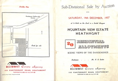
Flyer - Land Sales Brochure, Sub-Divisional Sale by Auction - Mountain View Estate, Heathmont, Victoria - 1957
Bi-fold pamphlet advertising auction of 20 residential allotments on Saturday, 14th December, 1957, with description of services available and finance terms. Subdivision inclues Orchard Grove and Barnic Road. Agent - Heathmont Estate Agency, 103 Canterbury Road, Heathmont, Telephone WU6808, after hours WF1488. Auctioneer Mr. A.B. Carter. Accompanying Parish of Ringwood survey map with cardboard backing - Part of Crown Allotment 14B, includes handwritten price notations for each allotment. -
 Ringwood and District Historical Society
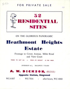
Flyer, Land Sale Brochure, Heathmont Heights Estate, Heathmont, Vic. - 1959
Bi-fold advertisement for sale of residential sites, including map and summary of subdivision features and local facilities. Subdivision includes Coven Avenue, View Court, and Miller Road. Agent - A.W. Dickson, Opposite Station. (Phone) WU6007, WU7016, after hours WU6868. Accompanying Titles Office Plan of Subdivision photocopy dated 1971 - Part of Crown Allotment 38A Parish of Ringwood. -
 Bendigo Historical Society Inc.
Document - LANDS OFFICE - PLANS FORWARDED TO CROWN LANDS OFFICE, 1.9.1871 to 5.4.1880
Document: hard cover journal, brown cover with darker tan spine. 239 pages. Contains index at front of journal. Listings of plans forwarded to Melbourne Crown Lands Office by Bendigo Office. Alphabetical listing in front followed by numbered pages with individual details. Parish, county, allotment, section, surveyor, date remarks.Lands Officelands office, sandhurst, bendigo, land sales, land surveyed, plans -
 Bendigo Historical Society Inc.
Document - LANDS OFFICE - CROWN LANDS SURVEYED AND SOLD - INDEX, 26.1.1857 - 1871
... lands office Bendigo Sandhurst crown lands sold rural land ...Document: hard cover journal, faded dark green cover with brown corners and spine. 193 pages filled out - LH page: Parish, town lands, suburban lands, country lands, total lands surveyed, date of survey RH page: date of sale, by auction, by selection, price per acre, total amount, name of purchaser. On spine ' 01, index book O'.Lands Officelands office, bendigo, sandhurst, crown lands sold, rural land. -
 Forests Commission Retired Personnel Association (FCRPA)
Beechworth FCV District office sign
This sign proudly hung outside the Forests Commission Victoria (FCV) Beechworth office which is now site of the Forestry Heritage Museum. The granite building in the Beechworth's historic precinct was once the Gold Warden's Office and is one of the town's original buildings. The FCV was the main government authority responsible for management and protection of State forests in Victoria between 1918 and 1983. The Commission was responsible for ″forest policy, prevention and suppression of bushfires, issuing leases and licences, planting and thinning of forests, the development of plantations, reforestation, nurseries, forestry education, the development of commercial timber harvesting and marketing of produce, building and maintaining forest roads, provision of recreation facilities, protection of water, soils and wildlife, forest research and making recommendations on the acquisition or alienation of land for forest purposes″. The Forests Commission had a long and proud history of innovation and of managing Victoria's State forests but in September 1983 lost its discrete identity when it was merged into the newly formed Victorian Department of Conservation, Forests and Lands (CFL) along with the Crown Lands and Survey Department, National Park Service, Soil Conservation Authority and Fisheries and Wildlife Service. After the amalgamation the management of State forests and the forestry profession continued but the tempo of change accelerated, with many more departmental restructures occurring over the subsequent four decades. Responsibilities are currently split between the Department of Energy, Environment and Climate Action (DEECA), Forests Fire Management Victoria (FFMV), Parks Victoria, Melbourne Water, Alpine Resorts Commission, the State Government-owned commercial entity VicForests and the privately owned Hancock Victorian Plantations (HVP).Large office sign. Hand painted in traditional FCV mission brown and gold colour scheme.forests commission victoria (fcv), forest signs -
 Bendigo Historical Society Inc.
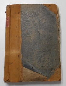
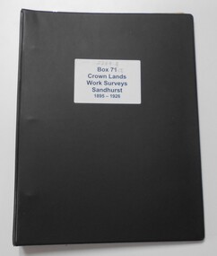
Photograph - CROWN LANDS WORK SURVEYS 1895 - 1926
Black folder contains 14 buff coloured foolscap booklets in individual plastic pockets, listing crown lands work surveys in Bendigo. Pages are handwritten.hospital, bendigo, crown lands work survey, surveying, land -
 Bendigo Historical Society Inc.
Document - LANDS OFFICE, CROWN LANDS SURVEYED AND SOLD SANDHURST DISTRICT, 1854 (?) onwards
Document: buff colour hard cover journal. Contains details of crown lands surveyed and sold. On LH page, town, suburban or country lands. RH page: auction, selection, price per acre, price and purchaser. Indexed by parish in front page. Two front pages cut out. On spine ' Index book' ' Lands and Survey' '06' 'E' ' Country' and 'Sales'Lands Officeplace, land sales, bendigo, lands office, land surveyed, land sold, sandhurst -
 Bendigo Historical Society Inc.
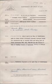
Document - H. A. & S. R. WILKINSON COLLECTION: CONTRACT OF SALE
BHS CollectionContract of sale of land dated 29th November, 1950 between Miss H. Barrass (vendor) and Mrs. M. Speer (purchaser). Property: lots 3 and 4 on plan of subdivision made by Alwyn Ernest Pritchard Licensed Surveyor dated the 19th of October, 1950 and being part of Crown allotment 230, 231, 232, 233 and 125 section H, Parish of Sandhurst City of Bendigo. Price: 3,700 pounds. Attached 8 hand written notes.organization, business, h.a. & s.r wilkinson real estate -
 Eltham District Historical Society Inc
Photograph - Digital Photograph, Alan King, Alistair Knox Park, Eltham, 2008
... of the land bought from the Crown in 1851 by Josiah Holloway, who... of the land bought from the Crown in 1851 by Josiah Holloway, who ...Alistair Knox Park, an oasis of peace and beauty. Covered under National Trust of Australia (Victoria) Landscape Significance and Heritage Overlay, Nillumbik Planning Scheme. Published: Nillumbik Now and Then / Marguerite Marshall 2008; photographs Alan King with Marguerite Marshall.; p173 It is hard to imagine that the Alistair Knox Park, an oasis of peace and beauty beside busy Main Road, Eltham, was once the township’s rubbish dump. It was only in the 1970s that the tip was transformed into this beautiful six hectare space, which later earned it a National Trust Landscape classification. Before its life as a dump, the area was used for small farms. Thanks largely to the foresight and efforts of local environmental builder Alistair Knox, the park was designed sympathetically with the character of the wider Eltham landscape. Then, appropriately, the park was named after Knox, who was an Eltham Shire Councillor from 1971 to 1975 and Shire President in 1975. The park designers were four major forces in the urban bush landscape garden –Knox, landscape designer Gordon Ford, artist Peter Glass and landscaper Ivan Stranger. The National Trust citation for the park, originally called Eltham Town Park, includes the Eltham railway trestle bridge and the Shillinglaw Cottage. The citation states ‘the semi-natural setting of the parkland provides a landscape which is evocative of the history of the area’. Manna Gums (Eucalyptus viminalis) and Candlebarks (Eucalyptus rubida) are significant features. Most of the park’s construction was directed by Bob Grant, Superintendent of the Parks and Gardens Department for the Eltham Shire Council. First plantings occurred in Arbour Week in 1973, then the lake and botanic area were completed in 1975, with Federal Government funding, and the toilet block in 1978. Bounded by the Eltham railway line, Panther Place, Main Road, Bridge and Susan Streets, the park is in a valley about a kilometre wide overlooked by steep hills at the east and west. The Diamond Creek flows through it and the picturesque historic timber trestle railway bridge edges the north. Informal plantings of Australian indigenous and native species in open and undulating grassed settings blend with the natural landscape of the Diamond Creek to the west. The bush-style plants, particularly around the creek, balance with open lawns, paths and a cascade flowing from a small lake to another below. A footbridge over the creek leads to the park’s west. The park includes an adventure playground and barbecue areas. The park stands on part of the land bought from the Crown in 1851 by Josiah Holloway, who subdivided it into allotments and which he called Little Eltham. Most of the land was subdivided into residential lots, but the creek valley, on which the park stands, was subdivided into farm-size lots, used mainly for orchards and grazing. One of the earliest owners was John Hicks Petty, who in 1874 bought a plot from Holloway. Other families who owned properties in that area, included Rees, Clark, Waterfall, Graham, Hill and Morant. In 1901 the railway was built through the area. Jock Read, an Eltham resident since around 1920, remembers several farms in the 1920s and ’30s that occupied the site of today’s park. A poultry farm, which extended from present day Panther Place, was owned by the Gahan family. Next to that farm was another for grazing cattle owned by Jack Carrucan. Beside this was land owned by John Lyon. A doctor lived beside this, and at the north-west corner of Bridge Street and Main Road stood a memorial to the soldiers who died in World War One, which was later moved to the RSL site. Mr Read also remembers other farms and orchards west of the creek In the early 1960s the Eltham Council began buying these farms and in the late 1960s turned the areas east of the Diamond Creek into a garbage tip. When this was filled above the creek’s flood plain, the tip was moved to the west of the creek.This collection of almost 130 photos about places and people within the Shire of Nillumbik, an urban and rural municipality in Melbourne's north, contributes to an understanding of the history of the Shire. Published in 2008 immediately prior to the Black Saturday bushfires of February 7, 2009, it documents sites that were impacted, and in some cases destroyed by the fires. It includes photographs taken especially for the publication, creating a unique time capsule representing the Shire in the early 21st century. It remains the most recent comprehenesive publication devoted to the Shire's history connecting local residents to the past. nillumbik now and then (marshall-king) collection, alistair knox park, eltham -
 Ringwood and District Historical Society
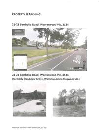
Archive - Parent Record, Family History - Collection of 1960s Land Titles and Property Records associated with Carter and Brown Families and others, Grandview Grove, (later Bemboka Road) Warranwood, (Parts of Crown Grant 20, 1854)
Set of four clear-fronted plastic A4 binders containing family history research printouts and photocopies. -
 Ringwood and District Historical Society
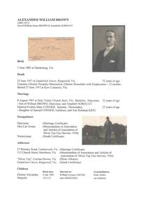
Document - Biography - Family Tree Extract, Alexander William Brown (1885-1957) - Nurseryman, Grandview Grove Ringwood (Warranwood) Vic
A4 folder containing genealogical information, copy of will and copy of probate administration record including real estate assets for A.W. Brown, Grandview Grove Ringwood (Warranwood) Vic.EXTRACT: Inventory of Real Estate Assets (for Probate purposes) 1. Grandview Grove, Ringwood Land containing 10 acres or thereabouts situate in Grandview Grove Ringwood being part of Crown Section 20 Parish of Warrandyte County of Evelyn and being the land described in Certificate of Title Volume 5781 Folio 174 on which is erected a 7 room house, a bungalow, shed and 2 glass houses valued by E. Miles, Ringwood - £5077-0-0 2. Kardinia Crescent, Ringwood Land containing 2 acres 3 roods 24-1/2 perches situate in Kardinia Crescent Ringwood being Lots 33 and 34 on Plan of Subdivision Number 12040 and being part of Crown Section 20 Parish of Warrandyte County of Evelyn and being the land described in Certificate of Title Volume 7141 Folio 080 valued by E. Miles at £350-0-0 -
 Ringwood and District Historical Society
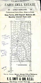
Flyer, Residential Land Sale Sub-division - Fairy Dell Estate, Warranwood, Vic. - circa 1950s
Land sale advertisement for 50 home sites with map of Sub-division showing layout of streets and allotments, summary of local features and services and terms of sale, and copy of sectional map of Crown Allotments 20 & 21B Parish of Warrandyte also showing layout of Sub-division.Subdivision includes Grandview Grove (later Bemboka Road), Merrill Crescent and Kerry Road, Warranwood. Estate Agents - V.C. Swift & Son R.E.S.I., Main Street, Croydon, Phone 20. Solicitors - Morgan, Fyffe & Mulkearns, 108 Queen Street, Melbourne. Handwritten 1970s real estate price notations for some blocks. -
 Glenelg Shire Council Cultural Collection
Functional object - Envelope, n.d
Brown envelope, 'J.L. Wyatt & Co. Auctioneer, Land Stock & Commission Agents Portland' printed on top left. Addressed by hand to H.L. Vivian, Percy St. Portland. Details of a crown allotment handwritten on front of envelope, in black ink and pencil.Back: 'Margaret Ann Clarke ?Lofty' - handwritten, black ink.betty vivian collection, auctioneer, municipality of portland -
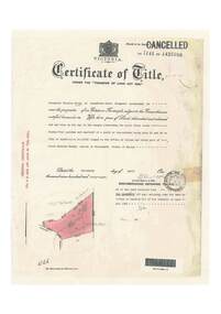 Ringwood and District Historical Society
Document, Certificate of Title - Alexander William Brown - part of Crown Section 20, Parish of Warrandyte, County of Evelyn - 16th April, 1948
A4 copies of Landata Victoria Historical Search documents - Vol 7141 Fol 1428080.Alexander William Brown of Grandview Grove (later Bemboka Road), Ringwood is now the proprietor of an Estate in Fee-simple subject to the Encumbrances notified hereunder ... 2 acres 3 roods 24 and one-half perches or thereabouts, being Lots 33 and 34 Kardinia Crescent, on Plan of Subdivision no.12040. Transfers include Alexander William Brown died 25th June, 1957, Probate granted 28th January, 1958, to Alfred Hart Brown of Dandenong, Estate Agent, and Harry Britten Elms of Cardinia, Gentleman, Oliver Burgess, Grandview Grove Ringwood, Florist - 14th May, 1964, Peter John Woodhead, Transport driver, and Shirley Margaret Woodhead, Married woman - 12th September, 1966. Inventory of Real Estate Assets (for Probate purposes 4/10/1957) detailed in Family Genealogy record for A.W. Brown includes: "Kardinia Crescent, Ringwood - Land containing 2 acres 3 roods 24-1/2 perches situate in Kardinia Crescent Ringwood being Lots 33 and 34 on Plan of Subdivision Number 12040 and being part of Crown Section 20 Parish of Warrandyte County of Evelyn and being the land described in Certificate of Title Volume 7141 Folio 080 valued by E. Miles at £350:0:0 -
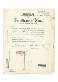 Ringwood and District Historical Society
Document, Certificate of Title - Leslie Mills of Plymouth Road, East Ringwood, Farmer - part of Crown Section 20, Parish of Warrandyte, County of Evelyn - 19th January, 1932
A4 copies of Landata Victoria Historical Search documents - Vol 5781 Fol 1156174.Leslie Mills is now the proprietor of an Estate in Fee-simple subject to the Encumbrances notified hereunder ... 10 acres or thereabouts, together with a right of carriage way over Grandview Grove (later Bemboka Road), Warranwood, Victroia. Transfers include Alexander William Brown of Tooradin, Farmer - 29th October, 1945, (died 25th June, 1957), Probate granted 28th January, 1958, to Alfred Hart Brown of Dandenong, Estate Agent, and Harry Britten Elms of Cardinia, Gentleman (*** See Probate details below) Oliver Burgess, Grandview Grove Ringwood, Florist - 14th May, 1964, Privatus Proprietary Limited, St.Kilda Road, Melbourne - 27th October, 1977, John Patrick Kelly, Company Director and Yvonne Gloria Kelly, Married Woman, joint proprietors, 10th September, 1980 *** Inventory of Real Estate Assets (for Probate purposes 4/10/1957) detailed in Family Genealogy record for A.W. Brown includes: "Grandview Grove, Ringwood Land containing 10 acres or thereabouts situate in Grandview Grove Ringwood being part of Crown Section 20 Parish of Warrandyte County of Evelyn and being the land described in Certificate of Title Volume 5781 Folio 174 on which is erected a 7 room house, a bungalow, shed and 2 glass houses valued by E. Miles, Ringwood - £5077-0-0 -
 Bacchus Marsh & District Historical Society
Map, Plan of Survey of Part of Crown Allotment 9, Parish of Korkuperrimul, 1890
This map documents a transfer of an allotment of land in Clarke Street Bacchus Marsh in 1890. Clarke Street is located on the eastern side of Bacchus Marsh not far from Main Street and Crook Street. It is now known as Candeloro Street. The map indicates J. Booth as the owner of the land and H. Simpson as the occupier. Next to this allotment is a an allotment of land owned by J. Elmore,Single page map showing Crown allotment 9, Parish of Korkuperrimul, County of Bourke. Scale 100 feet to inch. Part of a set of maps which are pasted into a bound volume containing 76 maps or plans in total. High resolution digital image stored on BMDHS computer network. At bottom of map: I hereby certify that I have made this survey expressly for the purpose of an application under the Transfer of Land Statute that this plan is correct. Barry B???, Lic. Surveyor, 16.10.90bacchus marsh victoria maps, clarke street bacchus marsh maps -
 Ringwood and District Historical Society
Map - Plans of Subdivision, Part of Crown Allotments 35 & 39, Parish of Warrandyte
Survey maps of stages 1, 2 & 3 of residential allotments in Kalinda Road and Grayling Crescent, Ringwood, Victoria. (Undated, circa 1960). Some allotments are marked with real estate information and prices in pre decimal £s.Adshead & McGuire, Land Surveyors L.S. M.I.S. (Aust), 268 Albert Street East Melbourne (Ref 118/2a b &c) Tel 41-6960. The land colored blue is set apart for drainage & sewerage purposes. Reference Marks (R.M's) are Gal Iron Pipes 12"x1". Levels shown are to M.M.B.W. Datum. The land shown hatched is subject to innundation. -
 Linton and District Historical Society Inc
Certificate of Title, Certificate of Title : Crown Allotments 27, 28, 29, 30, Section 4, Township of Linton
The land was transferred to Theophilus William Nelson and James Adolphus Nelson in 1929. James and Theo Nelson later (1955) acquired Allotment 36, Section 4 which adjoins these allotmentsCopy of Certificate of Title for several adjacent blocks of land on the corner of Clyde Street and Grantley Street in Linton. Copy is comprised of photostat sheets held together by tape.theophilus william nelson, james adolphus nelson, certificates of title, allotments 27 - 30 township of linton -
Lakes Entrance Historical Society
Book, Marjorie Morgan, Crown Lands Pre-emptive Rights Agreement, 1987
Fasimile reproduction of Victorian Government records giving valuation of Crown Lands under Pre emptive right originally printed in sixteen counties and four districts are included.settlers, surveying, land settlement -
 City of Moorabbin Historical Society (Operating the Box Cottage Museum)
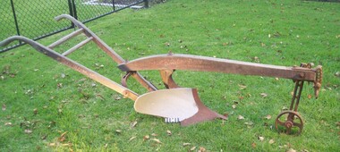
Machine - Farm Machinery, Plough, single mull-board, c1900
... 'Dendy's Special Survey' of 1841 and the Crown Land Sale in 1852 ...Circa late 1800's to early 1900s. A horse-drawn furrow plough was the most common type of agricultural implement used by the pioneer market gardeners, in Moorabbin Shire, of the 1800s and continued on into the 1940s when motorised tractors came into use. This plough is an example of a single-mullboard plough which would have been pulled by horse. The long handle was used to lower the silver plate, (mullboard), to the chosen depth of soil. Following 'Dendy's Special Survey' of 1841 and the Crown Land Sale in 1852, land allotments were bought by pioneer settlers who established or rented allotments for market gardens in the area and they supplied produce to the markets in St Kilda and Melbourne. During the gold-rush of the 1850s the rapidly increasing population of Melbourne saw a huge demand and a rise in prices for all foodstuffs, including the vegetables and fruit grown in the Shire of Moorabbin. An "Oliver" single mull-board plough in good condition with faded manufactures markings on shaftsPainted on shaft "MANF'D BY/OLIVER CHILLED PLOW WORKS/Southend Ind. USA/" Engraved on blade " 13 OLIVER"brighton, moorabbin, plough, dendy henry, east bentleigh, market gardens, horse drawn plough, plow, mullboard -
 Ringwood and District Historical Society
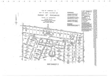
Document - Subdivision Plan, Part of Crown Allotment 32B Parish of Ringwood, County of Mornington Vol 6051 Fol 111 - LP26857
LANDATA Land Victoria 2-sheet plan printout dated 9/11/1953.Sheet 1 includes Lynwood Avenue, Isabel Avenue, Braewood Avenue, Maple Court, and Heathwood Street, Ringwood East, Vic. Sheet 2 includes Braewood Avenue, Rotherwood Avenue, and Heathwood Street, Ringwood East, Vic. Additional markings include LP46598, CP173330, LP86847, LP213448, LP217511, LP207217, LP56241. -
 Ringwood and District Historical Society
Document - Subdivision Plan, Part of Crown Allotment 19 Parish of Ringwood, County of Mornington Vol 3375 Fol 910 & Vol 3526 Fol 159 - LP5577
LANDATA Land Victoria 2-sheet plan printout dated 6/9/2011.Sheet 1 includes Warrandyte Road, Aird Street, and Pratt Street, Ringwood, Vic. Additional markings include LP19568 Sheet 2 includes Warrandyte Road, Aird Street, Pratt Street, and White Horse Road, Ringwood, Vic. Additional markings include SP25671H, CP100154, LP10519, LP28996 and P51182. -
 Ringwood and District Historical Society
Document - Subdivision Plan, Part of Crown Section 20 Parish of Warrandyte, County of Evelyn Vol 9622 Fol 554 - LP147813B
LANDATA Land Victoria 2-sheet plan printout dated 3/12/1985.Sheet 1 includes Sandhurst Grove and Chittingstone Drive (later Braden Brae Drive) Warranwood, Vic. Sheet 2 includes Standen Court and Chittingstone Drive (later Braden Brae Drive) Warranwood, Vic. -
 Ringwood and District Historical Society
Document - Subdivision Plan, LP12308 Crown Allotment 14C and Part of Crown Allotment 14A Parish of Ringwood, County of Mornington Vol 5378 Fol 511 - Circa 1927
LANDATA Land Victoria 4-sheet plan printout dated 2009.Sheet 1 includes Canterbury Road, Heathmont Road, Dickasons Road and Bennett Avenue, Heathmont. Additional markings include PC353066. Sheet 2 includes Heathmont Road, Bennett Avenue and Orchid Street, Heathmont. Additional markings include PS326369 and SP24567. Sheet 3 includes Dickasons Road and Bennett Avenue, Heathmont. Additional markings include LP46776, SP28005 and PS335189. Sheet 4 includes Dickasons Road, Bennett Avenue and Orchid Street, Heathmont. Additional markings include SP25998, SP31080, SP31780, SP25968, SP25969 and LP46475. -
 Ringwood and District Historical Society
Document - Subdivision Plan, LP11645 Part of Crown Allotment 26A, Parish of Ringwood, County of Mornington Vol 5164 Fol 1032616 - 1926
LANDATA Land Victoria 2-sheet plan printout dated 2009Sheet 1 includes Mount Dandenong Road, Valda Avenue and Velma Grove, Ringwood East. Additional markings include SP35514, SP22189, SP34206, SP35514, SP26794, PS319109, PS319010 and PS304868. Sheet 2 includes Mount Dandenong Road, Valda Avenue, Mirabel Avenue and Velma Grove, Ringwood East. Additional markings include SP26430, SP25320, PS341575, PS319110, PS319010, LP48415, SP22732, SP25844, PS304936 and PS304937. -
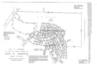 Ringwood and District Historical Society
Document - Subdivision Plan, LP83721 Part of Crown Portion 23, Parish of Warrandyte, County of Evelyn, Vol 8708 Fol 351, Vol 8745 Fol 148 and Vol 8751 Fol 034 - 1969
Double sided LANDATA Land Victoria 2-sheet plan printout dated 2009Sheet 1 map and Sheet 2 enlargement including Wonga Road, Holyrood Crescent, Harwick Close, Berkley Road, Frederic Drive, Kenwood Crescent, Adele Court and Marilyn Street, Ringwood. Markings also include LP83722 . -
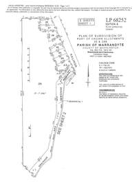 Ringwood and District Historical Society
Document - Subdivision Plan, LP113220 Part of Crown Allotments 35 & 39B, Parish of Warrandyte, County of Mornington, Vol 6421 Fol 183 & 184 - 1965
LANDATA Land Victoria 2-sheet plan printout dated 2009Sheet 1 includes Kalinda Road, Ringwood. Additional markings include LP113117. Sheet 2 includes Kalinda Road and Maroondah Highway, Ringwood. Additional markings include LP86253. Both sheets include location of Drainage and Sewerage Reserve along Mullum Mullum Creek.