Showing 1372 items matching "east side"
-
 Stawell Historical Society Inc
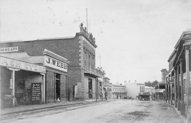
Photograph, C. Herbert Photo, Upper Main Street Stawell c1880, 1880s
Upper Main St. Looking East (Herbert Photo) Businesses are the Cash Store, J. Webb, J Allingham Draper, Chadwicks Draper, Commercial Hotel. Two Story Oriental Bank Building / O'Driscoll solicitors. Horse drawn cart in street. On right is the side of Mechanics Institute, R H Wadsworth Watchmaker. c 1880's. Victorian Views. C. Herbert, Photo. Stawell 1878streetscape, businesses -
 Stawell Historical Society Inc
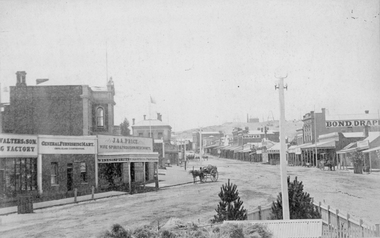
Photograph, Main Street Stawell looking East from the Present War Memorial site 1878
Main St. looking East towards Big Hill from Coffee Palace Verandah over Present War Memorial area. 1878 Businesses from left Walters and Son Factory, General Furnishing Mart, Stawell Town Hall, J. & A. Price Wine Spirits & Provision Merchants, Stawell Post Office. On right south side of Main Street, two-storey wooden Bull & Mouth Hotel, Whiteside Taylors, Carters Boot shop, Lecky Draper, C. Mulcahy Post Office Hotel, G.J. Hewlett Baker & Confectionery, Iron Monger, Victoria House Bond Draper, Town Hall Hotel, J. Richards Fancy Repository. Victorian Views. C. Herbert, Photo. Stawell 1878stawell business streetscape -
 Stawell Historical Society Inc
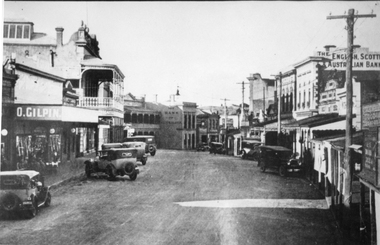
Photograph, Upper Main Street Stawell looking East 1930
Upper Main Street looking East c 1930. Two Story shop on left behind O. Gilpin is Chadwicks Draper later partially destroyed by fire. Some buildings not visible, Commercial Hotel then Oriental Bank / The Bank Australasia in Centre of Photo, Punchard's Furniture. On right of street, side of Mechanics institute, B.S. Dawson Chemists & R.H. Wadsworth Watchmaker, the English Scottish & Australian Bank on right. Clark & Scott Drapery. stawell streetscape -
 Stawell Historical Society Inc
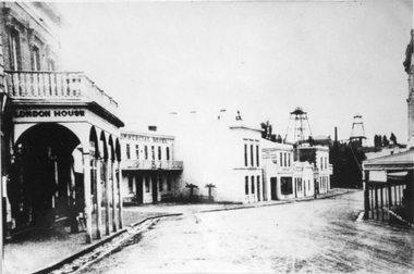
Photograph, Upper Main Stawell Street looking East with London House on the left 1880
Upper Main Street looking East. c 1880. Chadwick's Draper / Liddiard's / London House on left. Commercial Hotel, Oriental Bank / Bank of Australia, Punchard Furniture, Earlier Union Bank. Extended Cross Reef and Sloane and Scotchmans poppet Heads in Background.Street scene of north side of upper Main Street looking east. London House on left, Commercial Hotel near centre of image. Two poppet heads of mines at right distance.stawell streetscape -
 Stawell Historical Society Inc
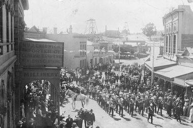
Photograph, Upper Main Street Stawell procession with the band & a police constable on Horseback visible c1901
Main Street Procession East End Circa 1901. Stawell Brass Band plus Constable on Horseback visible. J Chadwick Importer of General Drapery with Boys Clothing on sign on left. Millinery on side of verandah. Commercial Hotel just visible on left. Sloane's & Scotchmans Poppet head Visible in background on right. Poppet Head in background on Big Hill on left is Crown Cross shaft.Croud of people lead by band in upper main street. Chadwick drapers on left. Mounted policeman on horseback in front of Commercial Hotel.stawell businesses streetscape -
 Stawell Historical Society Inc
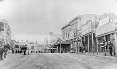
Photograph, Upper Main Street Stawell looking East with on left the 2 story Allingham building & behind the cart is the Commercial Hotel c1910 -- 2 Photos -- 1 Colour
Upper Main Street Stawell. Looking East c1910. On left two story Allingham building behind cart is Commercial Hotel. Oriental Bank. Punchard Furniture. Crown Cross Poppet head visible on Big Hill. The side of the Mechanics Institute visible near centre. H S Dawson Chemist. Clarke & Scott Drapery on right. Same as 6730-1 & 2785View along upper Main Street looking East towards Big Hill. Poppet Head in distance at centre.stawell streetscape, mining -
![Hand-Drawn Map Centred on Chiltern by Frank Lebbell Frost [ca 1915-1918]](/media/collectors/51d110e42162ef12e06aa06b/items/51fb08452162ef156c79a623/item-media/52a11e6d2162ef1f0c9c0af4/item-fit-380x285.jpg) Beechworth Honey Archive
Beechworth Honey ArchiveHand-Drawn Map Centred on Chiltern by Frank Lebbell Frost [ca 1915-1918]
This is one of the maps drawn by Frank L. Frost while he was beekeeping in North-East Victoria. This particular map may be reference in the "Wooden" Diary on pages 12, 13 and 17.Front Side: Hand-drawn map centred on Chiltern showing the Melbourne road [Hume Freeway] and the Beechworth-Rutherglen road with detailed locations of flora in the region. Flora includes; Iron Bark, Stringy Bark, Red Box and Yellow Box. Details regarding quantity of flowers and quality of trees is included. Back Side: Some names and addresses are recorded in pencil. Drawn with black pen and grey lead on paper. A grid and other symbols are marked in red ink.hand drawn, hand-drawn, map, chiltern, 1915, beekeeper, frost, beechworth honey -
 Beechworth Honey Archive
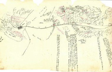
Hand-Drawn Map Centred on Ararat by Frank Lebbell Frost December 1916
This is one of the maps drawn by Frank L. Frost while he was beekeeping in North-East Victoria. This particular map may be reference in the "Wooden" Diary on page 11. Front Side: Hand-drawn map centred on Ararat, central Victoria. Details road and railway and vegetation with comments on flowering. Back Side: Comments in grey lead [ca 1923]hand drawn, hand-drawn, map, ararat, frost, beekeeper, beechworth honey -
 Williamstown Botanic Gardens- Hobsons Bay City Council
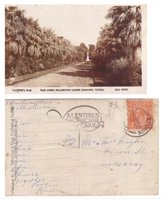
Postcard - Williamstown Botanic Gardens, circa 1900-1920
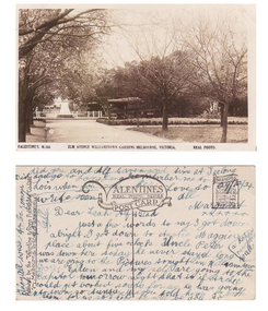
The original postcards in this series (2013.002 to 2013.018) were generously loaned to Williamstown Botanic Gardens by a private collector for copying. They are evidence of the interest the gardens held as a subject for postcard publishers. The text and images provide a snapshot into fashions, social interests and concerns of the time. The professionally produced images provide a pictorial history of Gardens including changing planting styles, various structures and features of the Gardens eg the aviary, cannons, the fountain, the second Curator’s Lodge and gates. The images offer an opportunity to compare garden vistas with the present day. This postcard shows the main east-west axial path with a typical Victorian/Edwardian mown grass strip which in turn borders formal shrub beds with herbaceous plantings. The photo was taken after the Mexican Fan Palms (Washingtonia robusta) planted in 1915, which in turn were replaced with the same species in 1987. Sepia postcard of the Palm Avenue at the gardens looking west to a white statue on a plinth. The statue is of Williamstown MLA, Alfred Thomas Clark. Palms and shrubs line both sides of the path and trees can be seen behind the statue. The shadows of the plantings are across the path.Front: VALENTINE’S, M.360 PALM AVENUE WILLIAMSTOWN GARDENS MELBOURNE, VICTORIA. REAL PHOTO. Reverse: vertical on left side of card and underlined: ‘Published by the Valentine & Sons Publishing Co. Ltd. / Melbourne. Sydney & Brisbane’. Top centre of card: Contains logo of ‘VALENTINES / REAL PHOTO SERIES / POSTCARD’. There is a red two penny Australian Postage stamp on the top right hand corner. The address of the sender is 1 Railway Place, Williamstown and the card is addressed to Mr and Mrs Nayler (?) in Footscray. The remaining writing unable to be deciphered postcard, gardens, post-card, williamstown-botanic-gardens, hobsons-bay-city-council, statue, clark, alfred-thomas-clark, palms, palm-avenue, valentine-and-sons -
 Williamstown Botanic Gardens- Hobsons Bay City Council
Postcard - Williamstown Botanic Gardens, circa 1900-1924
... Clark, with cannons on either side of statue pointing east down... Thomas Clark, with cannons on either side of statue pointing east ...The original postcards in this series (2013.002 to 2013.018) were generously loaned to Williamstown Botanic Gardens by a private collector for copying. The postcards are evidence of the interest the gardens held as a subject for postcard publishers. The text and images provide a snapshot into fashions, social interests and concerns of the time. The professionally produced images provide a pictorial history of Gardens including changing planting styles, various structures and features of the Gardens eg the aviary, cannons, the fountain, the second Curator’s Lodge and gates. The images offer an opportunity to compare garden vistas with the present day. This postcard is evidence of the placement of two of the cannons relocated from Fort Gellibrand in 1906 and that they were in place in the Gardens in 1924. They were removed from the Gardens in the 1960s. These same cannons remain a feature on the Williamstown waterfront in 2013. The image also shows the original Elm Avenue plantings. A sepia scene looking west towards statue of Alfred Thomas Clark, with cannons on either side of statue pointing east down what is known as the Palm Avenue. The statue is surrounded by a white fence consisting of posts and a top rail. The top of the statue is hidden by the branches of the elm trees. It appears that the elms are in the process of either losing their leaves or new leaf growth. A cactus plant can be seen beneath the lower branches of the elm tree of the right closest to the camera. The cannons were moved from Fort Gellibrand to the Gardens in 1906.Front: VALENTINE’S, M.356 ELM AVENUE WILLIAMSTOWN GARDENS MELBOURNE, VICTORIA. REAL PHOTO. Reverse: vertical on left side of card and underlined: ‘Published by the Valentine & Sons Publishing Co. Ltd. / Melbourne, Sydney & Brisbane’. Top centre of card: Contains logo of ‘VALENTINES / REAL PHOTO SERIES / POSTCARD’. Top right hand corner is stamped ‘BRANCHES (enclosed in a scroll) / SYDNEY / LONDON / DUNDEE / DUBLIN / CAPETOWN / MONTREAL / TORONTO’ The card is dated ‘29/12/24’ and addressed to ‘Dear Leah Alf & Dad’ signed by ‘Margaret’. postcard, gardens, post-card, williamstown-botanic-gardens, hobsons-bay-city-council, statue, clarke, alfred-thomas-clarke, cannon, elm, cactus, 1924, fort-gellibrand, 1906, armstrong, clark -
 Williamstown Botanic Gardens- Hobsons Bay City Council
Postcard - Williamstown Botanic Gardens
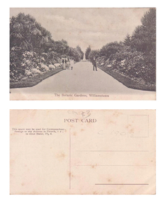
The original postcards in this series (2013.002 to 2013.018) were generously loaned to Williamstown Botanic Gardens by a private collector for copying. The postcards are evidence of the interest the gardens held as a subject for postcard publishers. The text and images provide a snapshot into fashions, social interests and concerns of the time. The professionally produced images provide a pictorial history of Gardens including changing planting styles, various structures and features of the Gardens eg the aviary, cannons, the fountain, the second Curator’s Lodge and gates. The images offer an opportunity to compare garden vistas with the present day. This postcard shows the main east-west axial path with a typical Victorian/Edwardian mown grass strip which in turn borders formal shrub beds with herbaceous plantings. The Cordylines which line and avenue in this image were replaced by Mexican Fan Palms (Washingtonia robusta) planted in 1915, which in turn were replaced with the same species in 1987. Black and White image of main path looking towards the statue of A C Clark. There is a man wearing a boater hat on the right side of the path and a woman and two children on the left side of the path. The path is lined with grass, shrubs and cycads. This image is before the border of the path was planted with palm trees, which was 1915.Front: ‘The Botanic Gardens, Williamstown’. Reverse: Top Centre ‘POST CARD’. Top left hand side ‘This space may be used for Correspondence. / Postage to any Address in Victoria, 1 d; / to other States, 11/2 d.’ Right side and top centre of card in pencil 'C1908' and '$3' [believed to be inserted by the vendor of the card]postcard, gardens, post-card, williamstown-botanic-gardens, hobsons-bay-city-council, garden-path, cycads, 1908, clark -
 Williamstown Botanic Gardens- Hobsons Bay City Council
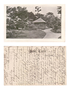
Postcard – Williamstown Botanic Gardens, c1900-1920
The original postcards in this series (2013.002 to 2013.018) were generously loaned to Williamstown Botanic Gardens by a private collector for copying. The postcards are evidence of the interest the gardens held as a subject for postcard publishers. The text and images provide a snapshot into fashions, social interests and concerns of the time. The professionally produced images provide a pictorial history of Gardens including changing planting styles, various structures and features of the Gardens eg the aviary, cannons, the fountain, the second Curator’s Lodge and gates. The images offer an opportunity to compare garden vistas with the present day. This card is a rare image of the original aviary built in the Gardens in 1892. The card also demonstrates how postcards were used as a method of contact in contrast to the contemporary use as souvenirs. The writer of the card, Polly, is anxious to receive a return postcard from Lila, writing that a reply should be sent that night. A black and white scene of a curving path with a square looking building at the centre. The 1894 MMBW plan shows that the building was triangular. The building is solid at ground level with the appearance of long vertical columns. The roof is light coloured and hip shaped with a finial at the apex. There is a garden set in the lawn on the left side of the image, shrubs and a palm at the left front corner of the building and tall trees in the background. The building is an aviary, which was built in north east section of the Gardens during 1892. The date of its removal is unknown. Front: ‘GARDENS, WILLIAMSTOWN’. Reverse: Centre top: ‘Post Card’; Vertical on left side: ‘P. & W. Series’; Right side ‘Address Only’. The card is addressed to Lila of ‘Ferguson St, N Williamstown’ from Polly. In pencil ‘1908 or later’ (believed to be inserted by the vendor of the card).postcard, gardens, post-card, williamstown-botanic-gardens, hobsons-bay-city-council, garden-path, aviary, 1908 -
 Williamstown Botanic Gardens- Hobsons Bay City Council
Postcard – Williamstown Botanic Gardens, c1900-1920
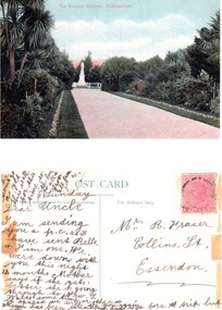
On 18 July 1891, a statue of local MLA Alfred Thomas Clarke was erected in a circular plot at the intersection of the major axial paths. AT Clarke was Williamstown's representative in the Legislative Assembly from 1871 to 1887, and a Commissioner of Trade & Customs in the third Berry Ministry. He did his utmost to defend Williamstown against the Melbourne Harbour Trust and was also the founder of the Advertiser. The statue was sculpted by Enrico Luchinelli in Cararra marble. The likeness was taken from a photograph.The postcards are evidence of the interest the gardens held as a subject for postcard publishers. The text and images provide a snapshot into fashions, social interests and concerns of the time. The professionally produced images provide a pictorial history of Gardens including changing planting styles, various structures and features of the Gardens eg the aviary, cannons, the fountain, the second Curator’s Lodge and gates. The images offer an opportunity to compare garden vistas with the present day. This postcard shows the main east-west axial path with a typical Victorian/Edwardian mown grass strip which in turn borders formal shrub beds with herbaceous plantings. The Cordylines which line the avenue in this image were replaced by Mexican Fan Palms (Washingtonia robusta) planted in 1915, which in turn were replaced with the same species in 1987 A colour image of main east west axial path looking towards the statue of A C Clarke enclosed with a white fence. The path is lined with grass, shrubs and Cordylines. This image is before the Cordylines were replaced with palm trees, which was 1915.Front: ‘The Botanic Gardens, Williamstown’. Reverse: Top ‘POST CARD’ Left side ‘The Space may be used for Correspondence’; Right side: ‘For Address Only.’ Top right corner is a red Victorian one penny stamp. The card is addressed to Mr R Fraser / Collins St. / Essendon from his niece, whose name is unclear. postcard, gardens, post-card, williamstown-botanic-gardens, hobsons-bay-city-council, garden-path, cordylines, clarke, 1891, enrico luchinelli, cararra marble -
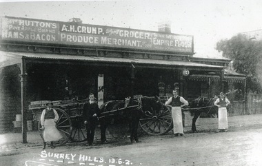 Surrey Hills Historical Society Collection
Photograph, Alfred Henry Crump's grocery and produce store in Canterbury Road, Surrey Hills, 1913, 1913
This building was adjacent to Surrey Lodge, on the corner of Canterbury and Union Roads. The store was established by George Sim in 1885 and in 1889 he set up the 1st Surrey Hills Post Office here. The business was bought by Alfred Claude Geer in 1909; the Camberwell Rate books show that from 1913 Geer remained owner but the business was occupied by Alfred Henry Crump; confirmed by electoral rolls for 1913-1918. Prior to moving to Surrey Hills, Alfred was a grocer in Dandenong. Otto Kuhn was Alfred Crump's store manager and may have taken this photo. Alfred married Hazel May Ordish in 1913 in Dandenong. The marriage notice in the Argus on 5 July indicates that the couple resided at 'Hazeldene' in Leopold Crescent. Moran and Cato had already established a business across Union Road from McNeill's Hotel and in time this business and one other grocery store opposite closed as a result.Black and white photo of A H Crump's grocery and produce store in Canterbury Road, Surrey Hills in 1913. There are 4 men and 2 horse-drawn carts in front of a timber single-storey building with a verandah with a corrugated-iron roof. At least one of the carts has "A H CRUMP" painted on the side. Three of the men are wearing long white aprons; the other, AH Crump, is in a suit. Advertising signs on the hoardings are for Huttons hams and bacon and Empire flour. Cadbury's cocoa is advertised on the shop window. The hoarding above the verandah also indicates that the business was established in 1884. There is a block-fronted single storey house with a picket fence adjacent to the shop, to the east along Canterbury Road."SURREY HILLS.13.6.2" diagonally across the bottom LH side of the photo.post offices, grocers, shops, businesses, horse drawn vehicles, alfred henry crump, alfred crump, alfred claude geer, alfred geer, otto kuhn, george sim, hazel may ordish, hazel may crump -
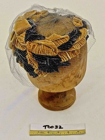 Brighton Historical Society
Hat, 1960s
Wreath of mustard and grey silk velvet leaves with bow at centre front, covered with grey tulle. Label, woven black on grey acetate, inside side back: PHONE 50 5347 / Mary H. Thomas, 103 WATTLETREE RD. EAST MALVERNhat, millinery, 1960s -
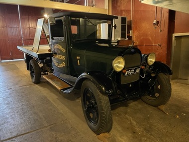 National Wool Museum
Vehicle - Ford Truck, Ford Motor Company, 1930
1930 AA Ford 1.5 tonne (30cwt) truck. Originally owned by Blakiston & Company, Geelong. Built in 1930, this truck carried wool and general goods in Geelong and the Western District until the early 1940s. It was restored in 1989-1990 by David Malkit Automotive, Belmont, Geelong East Technical School. Specifications: 4 cyclinder side valve engine 201 cu.in. capacity 24 hp (R.A.C.) rating 40 bhp @2200rpm Optional 4 speed non-synchronised gearbox Heavy duty rear axle with torque rod Transverse front springs Cantilever back springs Coach built cab and tray bodyDark green truck with painted lettering on door and tray. The cabin has a black bench seat, and body has a wooden tray.printed: NATIONAL WOOL MUSEUM / GEELONG / BLAKISTON & Co. / Pty. Ltd. / CARRIERS / GEELONG / No 1 Licence plate: WOOL - 30ford, truck, transport, 1930s, vehicles -
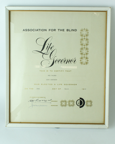 Vision Australia
Certificate - Text, Life Governor of the Association of Blind, 1969
To recognise the efforts made towards to the successful running of the Association for the Blind, certificates were awarded bestowing Life Governorships on individuals who had made significant contributions such as Mae Palmer of East Hawthorn became a Life Governor on 24th March 1969 for her contributions. This certificate is signed by President H. M. Lightfoot and Secretary J. W. Wilson.1 cream coloured sheet with decorative border on top right hand side and lower right hand corner, and the black and white symbol of the Association in the lower right hand corner consisting of a half circle with a flame and another half circle in blackAssociation for the Blind Life Governor This is certify that ... was elected a Life Governor on the ... day of ... 19..association for the blind, mae palmer -
 Vision Australia
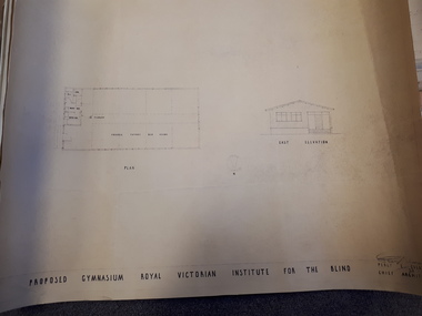
Plan - Image, Proposed Gymnasium Royal Victorian Institute for the Blind, 21 June 1950
In 1951 plans were made for the construction of a gymnasium to be situated in the grounds of St Kilda Road. These 4 plans specify the building construction notes, present front and east elevations, and show how part of the hall could be transformed into bedrooms in the future. There are 2 copies of each plan, consisting of identifical copies of the east elevation and different notes printed/handwritten on the front, side and top elevations. These were presented to the RVIB Board in Feburary 1951, according to the stamp on the back.2 architectural plans showing proposed gymnasium buildingPercy E Everett Chief Architectroyal victorian institute for the blind, plans -
 Port Fairy Historical Society Museum and Archives
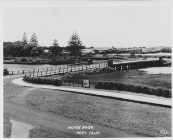
Postcard, Moyne River Port Fairy
... in 2016 Sole means for traffic to cross to the east side of Port ...This bridge was built in 1902, replacing a previous structure that crossed the Moyne River from 1857 and linked Belfast with Belfast East, as the two areas of Port Fairy were then known. Prior to that, passage over the river was via a ford (an underwater stone track that allowed wagons to cross when the river was low) located just north of where the current car bridge stands. The present bridge survived the great flood of 1946, but has been the subject of innumerable patch-up jobs over its 114 years. In 2012, the bridge underwent a detailed structural assessment and was given the OK for the next eight to 10 years, notwithstanding the need for regular maintenance works. At the time, it was estimated a new bridge would cost between $2-3 million. It was extensively refurbished in 2016Sole means for traffic to cross to the east side of Port FairyBlack and white photographMoyne River Port Fairyriver, moyne, bridge, road -
 Port Fairy Historical Society Museum and Archives
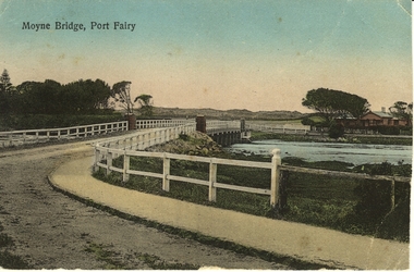
Photograph - Postcard, Moyne Bridge, Port Fairy
Hand tinted photograph of Moyne river road bridge taken looking East showing house on Griffith street on the right side in the background taken for use as a PostcardMoyne River, Port Fairymoyne bridge, 1910, river, road, gipps street -
 Surrey Hills Historical Society Collection
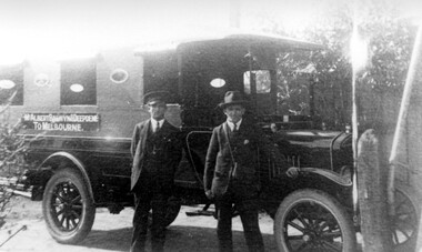
Photograph, Bus Service from Mont Albert, Balwyn, Deepdene to Melbourne
Man on the right is believed to be Mr Bowyer. A Mr Bowyer farmed land just east of Mont Albert Station around about the turn of the century - not known if there is any connection with that family. Car believed to be a 'T' Ford; driver and owner: Mr Bowyer; thought to have been taken in the early 1920s. We would like additional information or confirmation. A black and white copy of a photograph showing two men standing in front of a bus with a sign on its side identifying its destination as from Mont Albert, Balwyn and Deepdene to Melbourne. Both men are wearing suits and hats. Mr Bowes of Mont Albert(mr) bowyer, bovill family, transport, bus service, mont albert, deepdene, balwyn, t ford, (ms) ellena biggs -
 University of Melbourne, Burnley Campus Archives
Photograph - Sepia print, A.P. Winzenried, Pavilion, c. 1890
Notes by E.B. Littlejohn, "Note that the early Pavilion was built with 2 large entrances to allow horse drawn carriages to drive through. Entrance at centre of picture is on eastern side, not the front entrance which can be seen at extreme right and is well established." Note by T.H. Kneen, "The Pavilion early 1890's." The photo was adapted for use on the Diploma Certificate of the Royal Horticultural School, Burnley, Department of Agriculture.Copy of sepia photograph made by A.P. Winzenried for possible use in, "Green Grows Our Garden. Horse and cart and five students, 1 with a wooden wheelbarrow, standing and reclining on the lawn in front of the Pavilion.a.p. winzenried, green grows our garden, pavilion, horse and cart, east entrance, diploma certificate, students, students working outside, lawn -
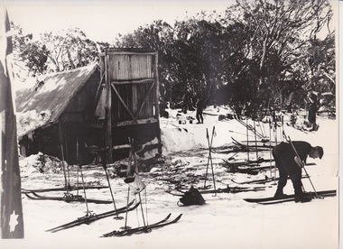 Falls Creek Historical Society
Photograph - At Wallace' s Hut
Wallace's Hut is the oldest surviving cattlemen's hut on the High Plains, built in 1889 by the three Wallace brothers - Arthur, William and Stewart. Their father David bought land at Kergunyah as well as grazing land on the banks of the Kiewa River, North East Victoria. Once the boys were old enough, the family followed the local squatters’ custom of taking their cattle up to the mountains for the spring and summer to fatten the mob, at the same time resting their home pastures. They decided to build a hut where they could shelter from the extreme mountain weather. The timber was cut from the forest about four hundred metres east of the hut, and the hearth stone was dragged in from Pretty Valley. The chimney had a base of rubble and above this iron sheeting on a timber frame. The slab walls were lined with hessian and later with tar-paper, and inside there was a bush table, sleeping platform and a rustic fire-side settle. The hut nestled among snow gums sheltered by a rocky outcrop. The names of the Wallace brothers were burnt into the tie-beams of the roof and at the back of the mantelpiece. The Wallace family’s lease expired in the late 1930s and the hut was bought by the State Electricity Commission to house staff on the High Plains and it became the first home of Toni and Skippy St. Elmo. The SEC covered the old shingles with iron, and later on the walls and chimney as well, and they added a lean-to. Wallace’s Hut is now owned by the Crown and maintained by Parks Victoria. It is on the Historic Buildings Register and is classified by the National Trust.This image is significant because it depicts an important heritage-listed structure and refuge for cattlemen and other travellers in Victoria's High Country.A black and white photograph of a skier outside of Wallace's Hut. Several sets of skis and poles are standing around and other skiers are in the background.wallace's hut, toni and skippy st. elmo, high country huts -
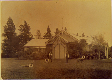
 Canterbury History Group
Photograph - Hazeldene, {1985}
Sepia photograph of the north side of "Hazeldene" 8 Balwyn Road Canterbury, looking towards the east.canterbury, balwyn road, hazeldene, cast iron work, verandahs, lead lights, outbuildings, danks family -
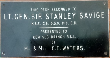 Kew RSL
Savige's campaign desk
Campaign desk. Probably Middle East New Guinea & Islands World War 2Wooden Desk 2 pedestals with drawers one side & cupboard & filing drawers on the otherPlaque attached to top: This desk belonged to LT. GEN. SIR STANLEY SAVIGE KBE CB DSO MC ED PRESENTED TO KEW RSL SUB-BRANCH by Mr & Mrs CE WATERSlt gen sir stanley savige, world war 2 -
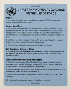
 Beechworth RSL Sub-Branch
Card, Rules of Engagement, UNTAET PKF-INDIVIDUAL GUIDANCE ON THE USE OF FORCE, 1999-2002
This card provided rules of engagement for Australian soldiers deployed to East Timor as part of UNTAET (United Nations Transitional Administration), an integrated, multi-dimensional peacekeeping operation fully responsible for the administration of East Timor during its transition to independence. UNTAET was the UN mission in East Timor, following its independence from Indonesia in 1999. The mission provided interim civil administration and a peacekeeping functions from 1999 until it was superseded by The United Nations Mission of Support in East Timor (UNMISET) following East Timorese elections in 2002. Small blue card with a gloss surface and rounded corners. Has text on both sides.UNTAET PKF-INDIVIDUAL GUIDANCE ON THE USE OF FORCEbeechworth, un, east timor, timor leste, peacekeeping -
 Beechworth RSL Sub-Branch
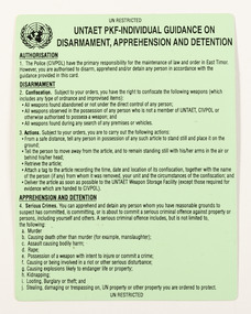
Card - Card, Guidance on the Use of Force, UNTAET PKF-INDIVIDUAL GUIDANCE ON DISARMAMENT, APPREHENSION AND DETENTION, 1999-2002
This card provided rules of engagement for Australian soldiers deployed to East Timor as part of UNTAET (United Nations Transitional Administration), an integrated, multi-dimensional peacekeeping operation fully responsible for the administration of East Timor during its transition to independence. UNTAET was the UN mission in East Timor, following its independence from Indonesia in 1999. The mission provided interim civil administration and a peacekeeping functions from 1999 until it was superseded by The United Nations Mission of Support in East Timor (UNMISET) following East Timorese elections in 2002. This information card was carried by all peacekeeping duty that could be referred to should it be requiredSmall green laminated card and rounded corners. Has text on both sides.UNTAET PKF-INDIVIDUAL GUIDANCE ON DISARMAMENT, APPREHENSION AND DETENTIONbeechworth, un, east timor, timor leste, peacekeeping -
 Beechworth RSL Sub-Branch
Card, Rules of Engagement, UNTAET PKF-INDIVIDUAL GUIDANCE ON DISARMAMENT, APPREHENSION AND DETENTION, 1999-2002
This card provided rules of engagement for Australian soldiers deployed to East Timor as part of UNTAET (United Nations Transitional Administration), an integrated, multi-dimensional peacekeeping operation fully responsible for the administration of East Timor during its transition to independence. UNTAET was the UN mission in East Timor, following its independence from Indonesia in 1999. The mission provided interim civil administration and a peacekeeping functions from 1999 until it was superseded by The United Nations Mission of Support in East Timor (UNMISET) following East Timorese elections in 2002. Small blue card with a gloss surface and rounded corners. Has text on both sides.UNTAET PKF-INDIVIDUAL GUIDANCE ON DISARMAMENT, APPREHENSION AND DETENTIONbeechworth, un, east timor, timor leste, peacekeeping -
Beechworth RSL Sub-Branch
Photograph - Photograph - unveiling of Cenotaph circa 1964, 12 April 1964
Cenotaph was construct in 1964 and unveiled that year Major General Sir Kingsley Norris was a leader in Victoria's medical community and a distinguished military officer. While serving in the Middle East during the Second World War Norris received the Distinguished Service Order. In 1943 he was honoured as a Commander of the Order of the British Empire for his distinguished service in the South-West Pacific. Photograph in a wooden frame painted black with glass front, hanging eyelet brass with hanging heavy gauged wire on the reverse side. Picture depict Sir Kingsley Norris standing in front of the cenotaph following the unveiling of the Australia Flag to reveal the plaque. In the background are RSL members and guests. The Union Jack is attached to the flag pole behind the cenotaph.UNVEILING OF CENOTAPH, SUNDAY 12. April, 1964 / By SIR KINGSLEY NORRIS KGE. CB. CBE. DSO / Donated by Verna. I. Mosscenotaph built to honour the anzacs