Showing 1137 items matching "house prices"
-
 Federation University Historical Collection
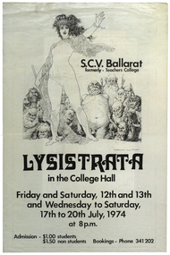
Poster, 'Lysistrata ' Production Poster, 1974, 1974
White paper poster with black text and drawing of a woman in front of some gruesome looking people. The the poster was for a State College Victoria (formerly Ballarat Teachers' College) production held at the college hall in Gillies Street, Ballarat.Front: "S.C.V. Ballarat, formerly - Teachers Collge, Lysistrata, in the College Hall, Friday and Saturday, 12th and 13th, and Wednesday to Saturday, 17th to 20th July, 1974, at 8 pm, Admission - $1.00 Students, $1.50 non students, Bookings - Phone 341 202" Back: "Lysistrata, by Aristophanes, CAST LIST, Lysistrata: Liz Stubbs, Kalonike: Joy Dunstan, Lampito: Jenny Tait, Myrrhine: Denise Maroney, Stratyllis: Ann Bilston, Interviewer: Tina Conroy, Kinesias: Michael Russo, Police Commisioner: Tony Ryan, Spartan Ambassador: Terrence Dorian, Spartan Herald; Shane Quick. WOMEN'S CHORUS, Sue Richards, Tina Conroy, Ann Bilston, Anne Giles, Glenda Hamilton, Janette Marshall, Gillian Hogan, Janine Grieg, Robyn Stanesby, Stephanie Buchanan, Janeen McCullough, Wendy Gray, Elizabeth Evans, Jenny Tait (Leader of Spartans), Mary Staindl, Barbara Price. MEN'S CHORUS, John Rowe, Stephen Schneider, Chris Slater, Peter Hassell, Errol Elbourne, Peter Orford, Kieth McDougall,Terrence Dorian, Robbie Eastcott, Shane Quick, Gary Oliver. MUSIC, Piano: Robbie Eastcott. Drums: Alex Traianou. Congas: David Murphy. Rhythm Guitar: Kim Hatcher. Bass Guitar: Shane Quick. Clarinet: Steve Albon. Flute: Tina Conroy. Acoustic Guitar: Tony Ryan. TECHNICAL CREW, Lighting: Austin Rickell, Sound: Stuart Tolliday, Keith McIvor, Design: Bruce Miller, Terrence Dorian, Set Construction: Bruce Miller, Terrence Dorian, Ken Jones, Choreograph: Cheryl Brown, Costumes: Gillian Hogan, Mary Staindl, Props: Denise Maroney, Jenny Tait, Publicity and Front of House: Ruth Newall. ACKNOWLEDGEMENTS, Meena Bazaar for the Jug, Turner Audio Systems. DIRECTED BY, Miichael D. Edwards. DIRECTOR'S NOTE, The sexual power of women is all persuasive. If, as Germaine Greer says, they stopped loving the victors, there would be genuine revolution. The idea of a sex strike to stop a war seems preposterous.... What else is left to the aware but politically emasculated woman? Aristophanes, like us, had been appalled by a pointless and hopeless war. Outrageous indignation had failed to stop it - so he resorted to comic absurdity; perhaps to shame the warmakers. Our version of the play is colloquial and probably ' in vogue'. It is colorful, musical, flippant, and not a little risque. It is, however, based on an awareness of the power of sex roles and the arrogance of a male-dominated society and a profound sense of frustration at the apparently immovable forces that make our wars and enact repression in all its forms."ballarat teachers' college, production, state college of victoria, ballarat, gillies street, liz stubbs, joy dunstan, jenny tait, denise maroney, ann bilston, tina conroy, michael russo, tony ryan, terrence doran, shane quick, sue richards, anne gillies, glenda hamilton, janette marshall, gillian hogan, janine grieg, robyn stanseby, stephanie buchanan, janeen mccillough, wendy gray, elizabeth evans, mary staindl, barbara price, john rowe, jeff moore, stephen schneider, chris slater, peter hassell, errol elbourne, peter orford, keith mcdougall, terrance doran, robbie eastcott, gary oliver, david murphy, alex traianou, kim hatcher, steve albon, austin rickell, stuart tolliday, keith mcivor, bruce miller, ken jones, cheryl brown, ruth newall, michael d. edwards, norman lindsay -
 Bendigo Historical Society Inc.
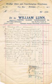
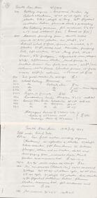
Document - WILLIAM LUNN INVOICE, 30/04/1923
William Lunn (1833-1916) was born i England where he learned cabinetmaking. He came to Australia in 1855 and initially partook in mining and puddling. He then became a salesman for Mr Henry King, painter and decorator. When King died in 1868, Lunn bought the business. In 1906 Lunn married the widow, Ann Jane Newman (nee Pinnell) . Ann and her first husband were neighbours of William Lunn who lived in "Esperence", Wills Street. Even whilst in business, Lunn remained an active mining investor.William Lunn Invoice: Cream paper with navy print and red and light blue lines. Dated April 30th 1923. Bendigo Glass and paper hangings Warehouse, TEL. 315 PALL MALL, Bendigo. Invoice no. 1595. Mr A Bush View Street. Dr. to William Lunn, Painter, Glazier, Paperhanger. &c. Dealer in glass of All Descriptions. Colours, Oils, Paints, Varnishes, &c. Terms - Cash. Paper hangings, Borderings of Newest designs, and panel Decorations. Invoice is for work to be carried out Painting etc, also lists materials and price. At the bottom is a orange Stamp Duty 2 pence stamp. Box 625business, retail, house furnishings, william lunn. a bush -
 Bendigo Historical Society Inc.
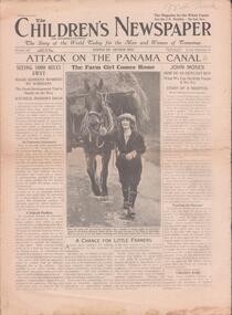
Newspaper - THE CHILDREN'S NEWSPAPER (10 ISSUES), 1924
The Children's Newspaper was a long-running newspaper published by the Amalgamated Press (later Fleetway Publications) aimed at pre-teenage children founded by Arthur Mee in 1919. It ran for 2,397 weekly issues before being merged with Look and Learn in 1965.Newspaper. Ten issues of 'The Children's Newspaper', from April 19 to July 26, 1924. A weekly issue edited by Arthur Mee. Each 12 pages. Price Twopence. Illustrated with B & W photographs. Printed and published by The Amalgamated Press, London. Page 7 of issue No. 266 has a photo of Australia's new Parliament House under construction.Handwritten in pencil on the top of each front page 'Mrs Bush'newspaper, newspaper, children, arthur mee, mrs bush, australia's first parliament house -
 Ringwood and District Historical Society
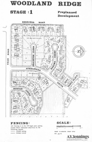
Flyer - Land Sale, Preplanned Development - Woodland Ridge Estate Stages 1, 2 and 3, Ringwood North, Vic. - circa 1972
Subdivison maps of Woodland Ridge Estate. Stage 1 includes Berringa Road, Oban Road, Athelstane Drive, Braimton Close, Karima Court, Tania Place, Runyan Court. Stage 2 includes Athelstane Drive, Cormiston Road, Linda Place, Casula Place, Oban Road. State 3 includes Williams Road, Athelstane Drive, Tania Place and Cormiston Road. Developer - A.V. Jennings Industries (Aust) Ltd., 690 Springvale Road, Mulgrave, 3170. Phone 560 8411. Supplementary page with early 2000s sale prices for eight addresses - 16 Athelstane Drive Ringwood 3134 $210,000 4/4/2000 19 Athelstane Drive Ringwood 3134 $235,000 14/1/2000 27 Cormiston Road Ringwood 3134 $246,000 28/10/2000 1 Runyan Court Ringwood 3134 $183,000 2/5/2001 4 Runyan Court Ringwood 3134 $179,000 14/8/2000 11 Runyan Court Ringwood 3134 $193,000 28/4/2000 7 Runyan Court Ringwood 3134 $187,500 14/1/2000 4 Casula Place Ringwood 3134 $216,000 13/2/2001 Accompanying handwritten notation by Richard Carter R.E.S.I. - "Purchaser of 'Pre-planned Development' lots also agreed to purchase the house planned for the lot. Bramton Court "Witheld" for display homes. Stage 3 one acre sites drained north therefore not readily sewered." -
 Marysville & District Historical Society
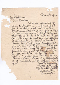
Letter (item) - Hand written letter, Mrs J. Richards, 04-12-1934
A digital copy of a hand written letter requesting the availability of accommodation at Marysville House for three weeks from January 8th, 1934. The writer has also requested the accommodation be priced at a discounted amount. Marysville House was built in the late 1920s by Arthur Dickinson.A digital copy of a hand written letter requesting the availability of accommodation at Marysville House for three weeks from January 8th, 1934. The writer has also requested the accommodation be priced at a discounted amount. Marysville House was built in the late 1920s by Arthur Dickinson.marysville, victoria, australia, marysville house, arthur james dickinson, grace dickinson, arnold spooner, eileen marie spooner, eileen marie dickinson, grace sweetland, eric dowdle, elsie may denton, elsie may dickinson, peter dickinson, linda dickinson, 2009 black saturday bushfires, letter, mrs j. richards -
 Melbourne Tram Museum
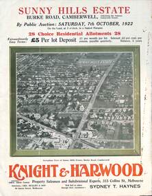
Ephemera - Real estate sale, Knight Harwood, "Sunny Hills Estate" - Burke Road Camberwell, Oct. 1922
Pamphlet advertising the sale of land at the "Sunny Hills Estate" Burke Road Camberwell 7-10-1922. Gives terms of sale, photos showing a nearby shopping centre, recently constructed houses, and plan of the subdivision. Land prices have been written in for each block on the pamphlet. Has a photo featuring Camberwell Junction with a tram, and Burke Road view with trams. Demonstrates the style of land sale pamphlet including the availability of tram services to prospective purchasers.Pamphlet - folded - printed in three colours of cream coloured paper with photographs and plans.has ink notes re sale price and notes.sale of land, trams, real estate, burke road, camberwell, sunny hills estate -
 Bendigo Historical Society Inc.
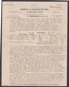
Document - BILL ASHMAN COLLECTION: CORRESPONDENCE
Typed notes titled 'Growing Plants Without Soil'. Typed on paper with printed letterhead of Howe & Franch Inc. Chemicals. Notes mention containers and method of planting plants for Hydroculture. Also gives the Formula to use in the water, price and size of the bottle of formula. Also mentioned that house plants watered with the formula improve their growth. Broadcast 'Final' written at the top of page.sciences, bill ashman collection - correspondence, growing plants without soil, howe & french inc. chemicals -
 Bendigo Historical Society Inc.
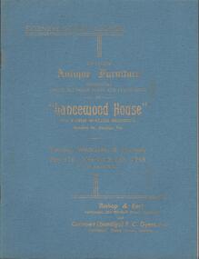
Book - AUCTION CATALOGUE - LANCEWOOD HOUSE, 1949
Auction Catalogue. Two copies of an auction catalogue for antique furniture and furnishings at 'Lancewood House', McLaren St. Bendigo. Contents of 18 rooms. Auction held over 3 days, May 31 to June 2. 1949. Auctioneers Bishop & Earl and Curnows (Bendigo) Prop. F. C .Dyett. Home once owned by Ernest Mueller. Catalogue includes 4 B & W photos of 3 rooms. Copy 'a' - Handwritten in ink on the first page 'Lydia Chancellor, Taraxville, Golden Square. Selling prices written against most items. 5 press cuttings re the auction are loose inside front cover. Copy 'b' - selling prices typed in against most items.Bishop and Earl, Curnows ( Bendigo)cottage, miners, lancewood house, auction, ernst mueller, bishop & earl, curnows (bendigo), lydia chancellor -
 Linton and District Historical Society Inc
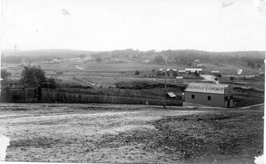
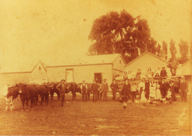
Photograph, Empire Post Card, Postcard showing the Grenville Standard building, 1909
Written on envelope attached: "This was sent to Aunty Mill from Aunty Grace. This photo was taken from our back gate opposite the post office. Miss Magan(?) was PM. The old Grenville Standard office run by Mr Adams. The little houses on the hill behind one was Mr Terrett a tailor who made the band uniforms. Mr Tom Bennett house butcher. The slaughter house is among the trees in the background. Note where the 'Law' is at the post office. I would like to see this enlarged. I think this photo is special because it shows the turntable where the trains used to turn before the rail went thru to Skipton which I remember all the [illegible] being made so many people working in Linton. As kids we loved to watch as the train came out facing a different way. The railway station master's house Mr Thompson was the SM. The old Grenville Standard office run by Mr Adams." Note: "Aunty Mill" = Amelia (Millie) Bennett, afterwards Millie Allen. "Aunty Grace" = Grace Bennett, afterwards Grace Wishart.Black and white postcard of Grenville Standard building with railway station and station master's house in background.On postcard: "Linton 30.6.09 [=1909] Dear Mill, you will be surprised at -- postcard and so soon. I forgot when writing, I wanted to ask you if Percy could get me a few dolls at wholesale price we are to have a bazaar for the church, and want to make something on our purchases. Let me know soon and I will get the money and quantity etc. required. Yours sincerely, Grace".grenville standard [newspaper], linton railway station, buildings, grace bennett afterwards grace wishart, amelia (millie) bennett afterwards millie allen -
 Ringwood and District Historical Society
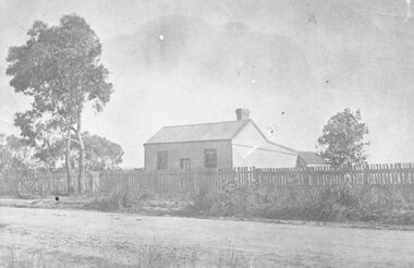
Photograph, The Lewis Findlay East Residence, Bedford Rd, Ringwood. 1901
Black and white photograph of weatherboard house surrounded by a picket fence. (2 copies- 1 large, 1 small). Typed notes detailing history of cottage.Typed notes contain the following: "Cottage and Lot 15, Sec.C, Township of Ringwood - comprising 1 acre - were acquired from the Crown by John Price on 17th July, 1888, for £30. Subsequently, a 4-roomed weatherboard cottage was built on Lot 15. On 21st May, 1901, the two allotments and the house were transferred to Lewis Findlay East for £85, and on 13th March, 1942, were sold to R. Barr and L. Beaumont for £650 with two additional rooms and some other improvements including reticulated water supply. Lewis Findlay EAST and his family occupied the cottage until 1910. It is believed that before the cottage was purchased by East, it was occupied for a period by McCubbin the artist. Lewis Findlay East was a member of an Australian Rifle Team which went to Bisley, England, in 1901, and won the Kalapore Cup. He was an officer of the Department of Customs, and later became Secretary of the Commonwealth Marine Branch, receiving the I.S.O. His son, Lewis Ronald East, became Chairman of the State Rivers and Water Supply Commission in 1936, and received C.B.E.". -
 Canterbury History Group
Ephemera - A charming period house in a prime position, 1998
Real estate advertisement for the auction on 15 August 1998 of 44 Balwyn Road Canterbury. Includes coloured photographs of the interior and exterior of the house and floor and site plans. Includes note by Robin Kelly of purchase price $450, 000 approx.canterbury, balwyn road, californian bungalows -
 Bendigo Historical Society Inc.
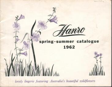
Magazine - HANRO COLLECTION: HANRO SPRING-SUMMER CATALOGUE 1962, 1962
The Hanro company was established in Switzerland in 1884. In 1926 a site in Hargreaves Street Bendigo, behind the School of Mines, was purchased to establish the Bendigo Knitting Mills, a subsidiary of Hanro. The managing director was Charles Handerchin who came from Switzerland. The company was delisted from the Australian Stock Exchange in 1963 when it was taken over by John Brown Industries.Hanro Spring-Summer Catalogue 1962: The cover is of card with a white background and black, green and mauve print. Printed on the cover in black is *Hanro* Spring-Summer Catalogue 1962* To the left is green leaves with mauve wild flowers on two stems and to the right side corner is also green leaves and two stems of mauve wild flowers. Underneath in mauve print is *lovely lingerie featuring Australia's beautiful wildflowers. Inside the cover is advertising the line. Inside the catalogue on white gloss paper are sketches of ladies wearing matching Negligee/Night set, night wear, Pyjamas, Petticoats, Vests Briefs, scanties', Panties, Bed Jackets, half slips, house coats and spencers. Each item has a number, description, size and colour. The back page has advertising. A green paper sheet has been inserted with the retail selling price list with item number size range and price. Over the page has the trade price, item number size etc. On the back cover on a white background is a box with a back border and *Hanro* printed inside along with the Sales Office, address and phone number in each State. Box 116ACambridge Press, Bendigobook, magazine, catalogue, hanro. catalogue. cambridge press, bendigo -
 Whitehorse Historical Society Inc.
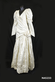
Clothing - Wedding dress, C 1992
Purchased 1992 from House of Brides, Box Hill. Price $1,000.1992 Cream Thai silk by ' Frank Stuart'. V-neck front and back, leg-o-mutton sleeves, self-rose decoration on the sleeves and hip. pearl trimmed neck and hipline; sleeves peaked at the wrist. Sloping angled hipline onto a gathered skirt.House of Frank Stuartwedding dress, silk, 1992, frank stuart -
 Bendigo Historical Society Inc.
Document - SOUTH NEW MOON MINE - MACHINERY SALE AT THE SOUTH NEW MOON MINE
Handwritten notes on a sale of machinery, etc at the South New Moon Mine on 13th July 1927. Sold under Bill of Sale. Notes list some lot numbers and the description of what they are. Some have the price they were sold for. Manager's house was also sold for 280 pound. Notes prepared by Albert Richardson.document, gold, south new moon mine, south new moon mine, machinery sale at the south new moon mine -
 Bendigo Historical Society Inc.
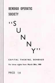
Programme - BENDIGO OPERATIC SOCIETY PROGRAMME ''SUNNY''
Programme Bendigo Operatic Society ''Sunny'' Capital Theatre Bendigo for three nights from March 30th, 1960. Price 1/6. Producer Mr. Charles Norman - Patricia McCracken as Sunny Peters - Fred Trewarne as Tom Warren - Annette Wilson as Weenie Winters - Bryan Brewer as Jim Deeming - Bram Schrever as Siegfried Peters - Emily Westgarth as Marcia Manners - Valerie McCracken as Sue Warren - Alfred Annison as Harold Wendall-Wendall Musical Director Max O' Loghlen - Society Pianist: Mrs. Phyllis House - Ballet Mistress: Miss Madge Welch. ''Sunny'' A Musical Comedy in two Acts Music by Jerome Kern, Book & Lyrics by Otto Harbach & Oscar Hammerstein. Cast in Order of appearance: Bally Hoo (The Barker); George Steele - Tom Warren: Fred Trewarne - Harold Harcourt Wendall (Owner of Wendall's Circus): Alfred Annison - Siegfried Peters (Manager of Circus: Bram Schrever - Sue Warren (Suzette): Valerie McCracken - Sunny Peters Patricia McCracken - Jim Deeming (A Friend of Tom Warren): Bryan Brewer - Weenie Winters: Annette Wilson - Sam (a Circus Rouseabout): Denis Cremin - Marcia Manners (Tom Warren's Fiancé): Emily Westgarth - 1st Officer: Peter Houston - 2nd Officer: Robert Nichols - Captain: Vincent Dáraugo - Specialty Dancers: The Dale Sistersprogram, theatre, bendigo operatic society -
Federation University Historical Collection
Book - Book - Press Clippings, Ballarat University College/University of Ballarat School of Visual and Performing Arts, 1993 - 1999, 1993
Blue cover book of press clippings. .1) 1993 - briar rabbit, brer rabbit, Libby Tanner, Lorrae Desmond, Cherry Orchard .2) 1994 - Bruce Widdop, Eureka, Rebellion, Aiden Fennessy, Steel Magnolias, Rumpilstiltskin, Tale of Two Cities, Peter Tulloch, Ring Round the Moon, Grainery Lane, Barnstorm Theatre, Rivers of China, Lord Wedgewood, Rick Chandler. James Charters, Matt Molony, Antoninino Atzori, Joseph, Len Bauska, Joseph and the Amazing Technicolour Dreamcoat, Damian Muller, Bert Labonte, Once a Catholic, Peta Brady, Fiddler on the Roof, King Richard III, The Seagull, Mr Men .3) 1995 - Point of Departure, Stags and Hens, Hansel and Gretel, Rob Knowles, The Would Be Gentlemen, SOund of Music, Barry Breen, The Bundle, Karl Hutton, Much Ado About Nothing, Len Bauska, Hamlet, Pajama Game, Peter Tulloch .4) 1996 Melissa Casey, The Wizard of Oz, Peter Tulloch, Libby Tanner, Rooted, Erard Concert Grand Piano, Atlantis. The Visit, Stella Axarlis, Me and My Girl, Our Country's Good, Three Billy Goats Gruff, Hold the Mayo, The Crucible, Chris Dickins, Stuart Pursell, Arts Academy .5) 1997 - Tempest at Loch Ard Gorge, Maelstrom, Angela Coad, Damian Muller, West Side Story, The Importance of Being Ernest, Mark Gambino, Brett Edgington, Cosi, Damian Muller, Leonard Bauska, Matthew Heenan, Amanda Sandwith, Bacchae, Richard DiGregorio, Roger Woodward, Peter Tulloch, Gavin Fenech, Bruce Widdop, Lola Montez, Tim Haymes, Tina Ford, Ross Jones .6) 1989 - Graeme Bird, Leanne Lettieri, Ballarat Symphony Orchestra, Christopher White, David Addenbrooke, Bruce Widdop, Chris Betts, John Garland, Allan Mann, John Sharpham, David Forrest, Warwick Stengards, Jan Davis, Wendy Morrison, Equus, Scott Cameron, Bryan Trueman, Peter Blizzard, Andrew Burnham, Peter Pilven, Chalk Circle, Tsou Nan-Chien, Ten Little Indians, Doug Wright, Stellarc, Chris Betts, Eric Lovett, Bob Allan, Doug Wright, Kaspar, Bill Levis, The Removalists, Liz Poklar, Goldfields Print Award, Margaret Sulikowski, Kathy Gamble, Maria Froia-Crump, Ian Hemmingway, Geoff Wallis .7) 1989 - Shirley Randall, Fred Sulikowski Fargher, Richard Jeziorney, Shane Lee, Neville Philpott, Val Lehman, Bill Levis, Hamp, Peter Ford, Shane Lee, Richard Akers, Peter Blizzard, Debbie Fraser, Shane Lee, Away, Genevieve Lacey, Pauline Coutts, Tsou Nan-Chien, Petrus Spronk, Debbie Fraser, Chris Betts, David Addenbrooke, Alan Peascod, John Crump, Deb Rosser, Michael Cook, Bruce Widdop, Jenny Trickey, Jennifer Marshall, Stellarc, Carboni, Stuart Matteson, Peter Sargeant retirement, Lyn Conellan .8) 1990 - Micehelle Tuddenham, Pauline Coutts, Anthony Horton, Claire Dale, Kryal Castle, Howard Tostivan, Simon Buckle, Blitz, STelarc, Hitz of the Blitz, Doug Wright, Nerissa Heath, Mieke Glickson, Ruth Greenburg, Peter SParkman, Allan Mann, Rachel Appleton, Michelle Tuddenham, Romeo and Juliet, Jennifer Pacey, Felicity Hay, Kristen Boys, Shane Lee, Norm Strange, Demolition Job, Merran Lisette, Charlotte's Web, Merran Hedbury, Richard Akers, Felicity Hay, Disco, Peter Harbison, Peter Clinch, Jeff Crispin, Cynthia Treadwell, Anagama Kiln, Debbie Lord, Sue Quinlan, Hedder Gabler, , Christine Hateley, Marilyn Chestnut, Geoff Crispen, Petrus Spronk, Peter Ashman, Country Heat, Bruce Widdop, Andrew Seary, Len Bauska, Christopher Pendlebury, Doug Wright, Frank Hurley, Peter Tulloch. Liz Blizzard .9) 1991 - Goldilocks and the Three Bears, Yvonne James, Doll's House, Liz Blizzard, Peter Blizzard, Elizabeth Tanner, Amanda Davies, Kimba Jeffries, Black Comedy and Public Eye, Peter Pilven, Macbeth, Richard Sutherland, Bruce Widdop, The Little Prince, The Would-be Gentleman, The Crucible, Warren Muschialli, Janet Dale, .10) 1992 - Deanne Clapton, Anthony Marsh, Alice in Wonderland, Bruce Widdop, The Beard, Fiona Bennett, Warren Muschialli, Orphans, Peter Blizzard, Red Riding Hood, Circus In a Suitcase, Frank Zappla, The Twelfth Night, Peta Brady, Street Angels, Lawrence Price, Donna Brunt, Jessi Watson, Too Much Punch for Judy, Miranda Crellin, Lyle Quick, Trevor Harris, Howard Tostivan, John Daykin, Barry Breen, The Paradise, Hansel and Gretel, Sandra Moon, Rosalind Lawson, Jason Wasley, The Paradise and The Passion, Simon Buckle, Sam Trinder, Doug Wright, .11) 1998 - Barnum, Skins, Marqui De Sade, Kangaroo Pie, Comedy of Errors, Manhatten, Nicholas Nickleby, Great White Way, Peer Gynt, Boys from Syracuse, Cancerto, Miranda Crellin, Ron McLeod, Alexandra Meerbach, Nathan Firmin, Chris Dickins, Christine Ward, Judith Roberts, Tim Arundell, Dom Phelan, Paul Thomas, Rose Tonkovic, Jon Peck, Andrew Page, Luke Doxey .12) 1999 - Pirates of Penzance, Phil Horwood, Adrian Barnes, Dennis Olsen, Kate Gorman, Nathan Firmin, Margaret Whitlam, Nadine Collins, Liz Gutt, Sara Brett, Kate McLennan, Dom Phelon, Midsummer Night's Dream, Bruce Widdop, Nadia Andary, Amy Maiden, Sing For Your Supper, Tania Burn, Under Milkwood, A month of Sundays, Matt Heyward, Dane Carpenter, Peter Tulloch, phil Crompton, Tim Haymes, David Haymes, Jenny Haymes, Barry Wemyss, Heather Kent, Monty Farag, Sancho de Silva, Jose da Costa, Cameron Sweatman, Ways and Means, Matt Heywood, Rebecca McGuiness, Michelle Pitcher, Peter Tullochperforming arts, visual arts, ballarat academy of performing arts, peter tulloch, bapa -
 Royal Australian and New Zealand College of Obstetricians & Gynaecologists (RANZCOG)
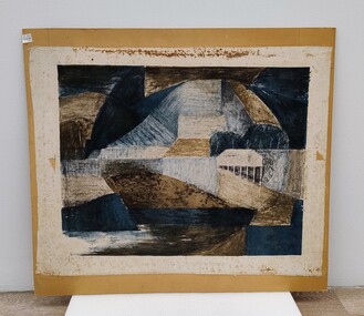
Painting, John 'Jack' Courier, Blue Landscape
It is likely this item was received from the estate of John 'Jack' Courier. Courier left a bequest to the College consisting of a significant number of artworks by himself and others.Abstract artwork on paper. Artwork consists of a range of geometric shapes in shades of blue, brown and black. The artwork has been adhered to a piece of brown board. Title of work written at bottom left is partly obscured, but appears to read 'Blue Landscape'. The artist's name is handwritten at bottom right and reads 'J. Courier 5/12'. The board appears to have been previously housed inside a frame, as the back edges of the board have suffered losses from the removal of tape. Handwritten inscription on the back of the work has been partially lost, but reads '...E LANDSCAPE/J. COURIER/368 TOORAK RD/STH YARRA/Price $22'. There are four small stickers from Gibson's Auctioneers attached to the back of the artwork. -
 Whitehorse Historical Society Inc.
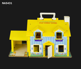
Education kit - Doll House, Fisher Price, Fisher Price Play House (1970s), c1970's
... Fisher Price Play House (1970s)...Fisher Price play family House... toy Doll house Toy c1970s Nunawading Toy Library Fisher Price ...C1970's doll house used in a community toy libraryC1970's toyPlastic, mostly yellow; Coloured transfer decoration; 2 storey house with garage; 4 dormer windows; Plastic furniture; Plastic people; Carry mantle. Fisher Price play family Housedoll house, toy, c1970s, nunawading toy library -
Clunes Museum
Magazine - AUSTRALIAN WOMENS WEEKLY, CONSOLIDATED PRESS LTD, 17/02/1951
IT WAS FOUND IN THE HOUSE WHERE MRS L. HUDSON USED TO LIVE.THE AUSTRALIAN WOMENS WEEKLY 17.FEBRUARY 1951 WITH PHOTOGRAPH SARA QUADS. PRICE 6 PENCE [5 CENTS]local history, magazine, hudson laura -
 Lakes Entrance Historical Society
Photograph, George Price Grant Metung, 1905 - 10
... Myrtle Fish nee Grant daughter of George Price Grant ...Myrtle Fish nee Grant daughter of George Price GrantSepia toned photograph showing George Price Grants bullock team and waggon with school children and parents ready for Sunday picnic taken near hotel at Metung Victoriagenealogy, settlers, houses -
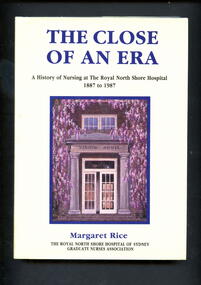 Alfred Hospital Nurses League - Nursing Archive
Book - Illustrated book, Margaret Rice, The close of an era: a history of nursing at the Royal North Shore Hospital, 1887 to 1987, 1988
This book is an account of the development of nursing practice as the original North Shore cottage hospital progressed to becoming one of the major medical institutions of Australia.Illustrated book with dust jacket. Book has a purple cover with full title and authors name in gold on front, authors name and abbreviated title in gold on spine. Dust jacket is cream in colour, with authors name and full title printed in purple ink on front. Authors name and abbreviated title printed in purple ink on spine. Also on front cover is a painting by Kevin Jopson of the entrance to Vindin House (nurses' home at Royal North Shore Hospital).non-fictionThis book is an account of the development of nursing practice as the original North Shore cottage hospital progressed to becoming one of the major medical institutions of Australia.royal north shore hospital-sydney-history, nurses, nursing -
 The Beechworth Burke Museum
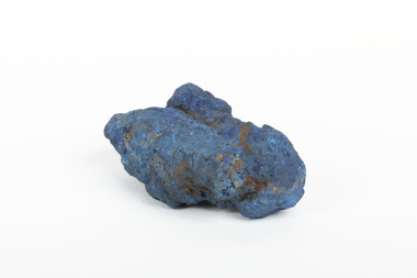
Geological specimen - Azurite, Unknown
Azurite is a secondary copper mineral made by the weathering of copper sulphide ore deposits. Azurite is formed from copper, carbon, oxygen and hydrogen. There are over 45 forms of azurite that are more well-known, however over 100 forms have been found. Azurite is also commonly found together with Malachite, and Azurite is often psuedomorphed to Malachite. This specimen was found at the Great Cobar Copper Mine in New South Wales, which was founded in 1870. At the time it was one of the largest mining operations in the world. It was the largest copper mine in Australia and housed the southern hemisphere’s tallest chimney stack. The international price of copper collapsed at the end of World War 1 which led to the closure of the Great Cobar Mine on March 16th 1919. A year later on March 10th 1920 an underground fire in the CSA (Cornish, Scottish, Australian) mine started and burned for 16 years. The closure of the mine and the fire left thousands jobless and many people left the area. These were factors in Cobar facing a long stretch of poverty, until a boom in the 1960s led to the reopening of the mine. The mine still operates today, obtained by Metals Acquisition Limited in June 2023. Azurite is considered an uncommon mineral. Named for its deep blue colour, azurite was historically used for pigment making and as a gemstone, despite its softness. This specimen was donated to the Burke Museum between 1868-1880 as part of a larger collection of geological and mineral specimens. Many of the specimens in this collection were obtained as part of the Geological Survey of Victoria, which started in 1852. The Survey aimed to map the scientific makeup of the earth.A solid copper mineral with shades of darker blues almost covering it.burke museum, beechworth, indigo shire, beechworth museum, geological, geological specimen, mineralogy, cobar mines, great cobar copper mine, cobar mining, new south wales, azurite, azurite specimen -
 Marysville & District Historical Society
Ephemera (item) - Price list, 2005
A price list for the various treatments available at villa day spa at The Cumberland guest house in Marysville. The list dates from October 2005.A price list for the various treatments available at villa day spa at The Cumberland guest house in Marysville. The list dates from October 2005.marysville, victoria, australia, the cumberland guest house, villa day spa, accommodation, price list -
 Ringwood and District Historical Society
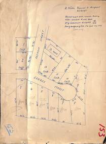
Map, Subdivision Plan - House and 13 residential allotments fronting Fremont Street Ringwood, Vic., and George Street (later Tudor Court), Heathmont, Vic. - Undated, circa 1922
Hand-drawn map on cardboard backing.Formed road with concrete kerbing. Water available to each block. No. of subdivision A139880 73/419. Part of Certificate of Title Vol 5323 Fol 539. Real estate sales notations on some allotments include price. Heading also includes address and phone number of H. Willis, Fremont Street Ringwood - WU6073. -
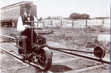 Chelsea & District Historical Society Inc
Photograph - Mordialloc Railway Station, Mr Pain, Railway Ganger, late 1860's
Black and white photo of a railway ganger, Mr Price, riding a railway tricycle at Mentone Station. In the background are a "Swing Door" carriage and in the distance two houses.mordialloc, railway, railway ganger, railway tricycle, tait carriages -
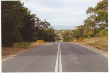 Lakes Entrance Historical Society
Photograph - Palmers Rd. Lakes Entrance 2008, Wendy Price, 1/08/2008 12:00:00 AM
Colour photograph of Palmers Road looking south overlooking houses and ocean Lakes Entrance Victoriaroads and streets, development -
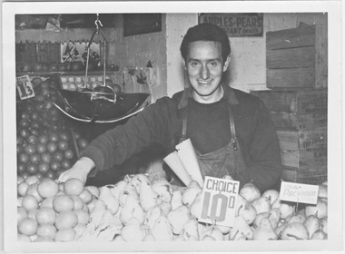 Ithacan Historical Society
Photograph, Dennis Black, c1950s
The young man in the photo is Dennis Black. He along with his brother, Steve worked with their father John at the family fruit stall in Camberwell Market. A scanned non-digital black and white photograph of a young man behind a fruit stall in a market. He has a paper bag in his hand and is preparing to serve a customer. There are wooden fruit packing cases stacked behind and the fruit prices in imperial currency, are displayed on individual plastic tickets. dennis black, fruit stalls, fruit vendor, camberwell market