Showing 10952 items matching "land "
-
 Narre Warren and District Family History Group
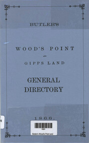
Book, Henry Young et al, Butler's Wood's Point and Gipps Land general directory 1866, 1985
This directory records a lot of different towns with the residents listed with their occupations Included as well is a lot of advertisements from these days97 p.; 22 cmnon-fictionThis directory records a lot of different towns with the residents listed with their occupations Included as well is a lot of advertisements from these daysbank of vic, cleland depot, gippsland land steam navigation co., mcdonald photographic studio, woods boarding house -
 Ringwood and District Historical Society
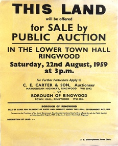
Poster, Land for Sale by Public Auction, Lower Town Hall, Ringwood - Saturday 22nd August, 1959
Yellow poster and smaller attachment with auction details and summary of four properties offered under Borough of Ringwood instructions for unpaid rates, some with handwritten monetary notations.Lot 49 Patterson Street, East Ringwood (Opp. station). Made Road, Water and E.L. 60'x220' approx. Lot 48 Stoda Street, Heathmont. Water and E.L. 50'x150'. Lot 86 Cnr Heatherbrae & Burwood Avenues, Ringwood. Made roads, Water and E.L. 54'x140' approx. Lot 13 Tagell Road Ringwood. 64'x1130' approx. For further particulars apply to C.E. Carter & Son, Auctioneer, Maroondah Highway, Ringwood (Phone) WU6042, WU6830, or Borough of Ringwood, Town Hall, Ringwood (Phone) WU6616. F.P. Dwerryhouse, Town Clerk. -
 Ringwood and District Historical Society
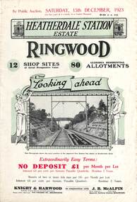
Flyer, Subdivisional Land Auction Sale Brochures, Heatherdale Station Estate, Ringwood, Vic. - 1923 and 1924
Two double sided multi-folded pages advertising public auction sales of shop sites and residential allotments on Saturday, 15th December, 1923 and Saturday, 2nd February, 1924, including summary of local facilities, services and map showing layout of the estate. Includes a photograph depicting proposed site for first Heatherdale railway station and a panoramic view of Ringwood from the railway level crossing in Heatherdale Road. 1923 and 1924 flyers are identical except for the auction dates printed at the top.Subdivision includes Heatherdale Road, Molan Street, Yallourn Parade, Newman Street, and Madden Street. Agents - Knight & Harwood, 315 Collins Street, Melbourne, Phone 10615, 10616 Central, in conjunction with J.B. McAlpin, Opposite Railway Station, Ringwood. Phone Ringwood 7. Additional cardboard-backed copy of map includes later penciled sales notations for some blocks (VC 5801 refers). -
 Narre Warren and District Family History Group
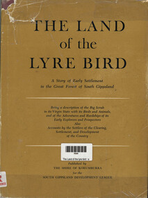
Book, The Land of the lyre bird : a story of early settlement in the great forest of South Gippsland, 1966
A story of early settlement in the great forest of south Gippsland. Being a description of the Big Scrub in its virgin state with its birds and animals, and of the adventures and hardship of its early explorers and prospectors; also accounts by the settlers of the clearing, settlement, and development of the countrynon-fictionA story of early settlement in the great forest of south Gippsland. Being a description of the Big Scrub in its virgin state with its birds and animals, and of the adventures and hardship of its early explorers and prospectors; also accounts by the settlers of the clearing, settlement, and development of the countrysouth gippsland, korumburra (vic.), land settlement, victoria, gippsland, personal observations, history -
 Narre Warren and District Family History Group
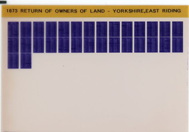
Film, Tim Wilcock et al, Return of Owners of Land Yorkshire (East Riding), England 1873, 1992-1995
"This return is intended to show with regard to England and Wales (exclusive of the Metropolis) - 1. The number and names of owners of land of one acre and upwards, whether built upon or not, in each County, with the estimated acreage and annual gross estimated rental of the property belonging to each owner 2. The number of owners of land, whether built upon or not, of less than one acre, with the estimated aggregate gross estimated rental of the lands of such owners 3. The estimated extent of commons and waste lands in each County."--Explanatory statement.Set of 1 microfiche non-fiction"This return is intended to show with regard to England and Wales (exclusive of the Metropolis) - 1. The number and names of owners of land of one acre and upwards, whether built upon or not, in each County, with the estimated acreage and annual gross estimated rental of the property belonging to each owner 2. The number of owners of land, whether built upon or not, of less than one acre, with the estimated aggregate gross estimated rental of the lands of such owners 3. The estimated extent of commons and waste lands in each County."--Explanatory statement. yorkshire -- east riding, yorkshire -- east riding -- land tenure, yorkshire -- east riding -- genealogy -
 Federation University Historical Collection
Document - Documents, Tourello: Opening of Tourello Bridge; Tourello Hunt Club, 1909; Tourello Tennis Club; Government Land Auction, 1855
Maps and typed documentstourello bridge, hunt club, tennis club, government land auctions, talbot, clunes, coghill, lenaghan, peter lalor, r. kinnersly, d.t. anderson, ralph willis, creswick -
 National Vietnam Veterans Museum (NVVM)
Booklet, Australian Army, Australian Army: Manual of Land Warfare, Part One: Volume 3, Pamphlet No.1: Counter-insurgency Operations 1980, 1980
A grey cardboard cover with black information on the cover. Top right hand corner reads 7610-66-097-7299. Under the Australian Army insignia are the details of the booklet. There are two punch holes down the left hand side. The booklet is covered with a plastic cover and there is a white label on this with 355.540 M2941:C Aus typed on the label.australian army, land warfare, counter-insurgency operations -
 National Vietnam Veterans Museum (NVVM)
Booklet, Australian Army, Australian Army: Manual of Land Warfare, Part Three: Training. Volume 1: Training For War, Pamphlet No. 6, Instructor's Handbook, 1984
An olive green cardboard cover with black information on the cover which is hard to read. Top right hand corner reads 7610-66-120-5877. Under the Australian Army insignia is the description of the handbook. There are two punch holes down the left hand side.australian army, land warfare, training, instructions handbook -
 Federation University Historical Collection
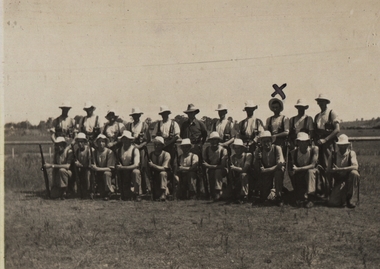
Photograph - Black and White, Chatham-Holmes Collection: Group of men - Land Army?
chatham-holmes collection, uniform dress, rifles -
 Ringwood and District Historical Society
Newspaper, Scrapbook Clipping, Library Collection, Ringwood, Victoria, `
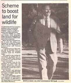
``Newspaper clipping from "The Mail", 4-7-95, P 6. NEWS WATCH- Scheme to boost land for wildlife Maroondah City Council is pushing to have several local reserves awarded "Land for Wildlife" status in an effort to protect local flora and fauna. A council reserve at the western end of Tereddan Drive in Kilsyth South was recently awarded Land for Wildlife Status` -
 Warrnambool and District Historical Society Inc.
Original Document, Map: Agricultural area of Ballangeich 1865, 1865
George Eddington arrived in Australia in 1839 and named and established property in 1841 calling the property Ballangeich after a Pass near his home town of Stirling in Scotland. It is situated 151 miles west of Melbourne and to the south of Mortlake and was originally part of the Mortlake shire, which was proclaimed 26th Jan 1864. Nearest streams are the Hopkins Riverand Lyall and Drysdale creek running through good agricultural land. This map relates to the breaking up of large runs which the Victorian government enabled through selection acts of the 1860's. The previously larger runs which were mainly cattle and sheep based were now more open to closer settlement and a greater variety in farming.The lots range in size from approximately 50 acres to around 600 acres.Some areas are set aside for reserves. By 1886 the population of Ballangeich had grown to around 600 with an hotel, three state schools and a church.Tri weekly coaches ran to Colac, Warrnambool and Camperdown providing access to supplies mail and communication. This map is typical of many which were produced in the 1860's in Victoria during a significant period of Victoria's and Warrnambool district history.Rectangular light card paper with black text showing allotments of land The area is coloured in green with scale at bottom right cornerAt the top: Plan of the Agricultural area of Ballangeich 1865 At the bottom left: Prepared by the Board of Lands & Works in accordance with the Amending Land Act 1865 Lands & Survey Office Melbourne 13th April 1865. With signaturehistory of warrnambool, ballangeich, land surveys victoria 1865, lands act 1865 victoria, ballangeich map 1865 -
 Bendigo Military Museum
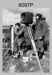
Photograph - Army Survey Regiment Personnel – Mahogany Ship Survey, Warrnambool, VIC, 1985
This is a photograph of Army Survey Regiment personnel undertaking surveying measurements during a search for the ‘Mahogany Ship’ Warrnambool, VIC on 3rd September1985. CPL Mark Lander and SGT Don Williams were taking electronic distance measurements using an MRA-301 tellurometer. To measure the distance, personnel at another site operating another MRA-301 tellurometer would have exchanged the signal emission. A ‘Hilga Watts’ light appears in the background and a barometer in the foreground.This is a photograph of Army Survey Regiment personnel undertaking surveying measurements during a search for the ‘Mahogany Ship’ Warrnambool, VIC on 3rd September1985. The photograph was printed on photographic paper and is part of the Army Survey Regiment’s Collection. The photograph was scanned at 300 dpi. L to R: CPL Mark Lander, SGT Don Williams‘R.S. 3/9/1985 CPL Mark Lander, SGT Don Williams PIC BY COURTESY OF THE WARRNAMBOOL STANDARD’ annotated on back of photoroyal australian survey corps, rasvy, army survey regiment, army svy regt, fortuna, asr, surveying -
 City of Moorabbin Historical Society (Operating the Box Cottage Museum)
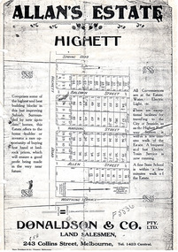
Flyer - Allan's Estate, Highett, 1922
The train line from the city to Frankston was electrified in 1922 which intensified the sale in the municipality of Moorabbin, particularly land which was in the vicinity of the railway stations.Example of the progress of the Municipality of MoorabbinPhoto copy of advertising flyer for auction of real estate sales - plan of building blocks for saleAllan's Estate, Highett land saleshighett road, baldwin street, harding street, allen street, highett, real estate, auctions -
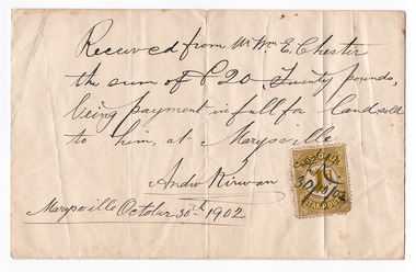 Marysville & District Historical Society
Ephemera (Item) - Land sale certificate, Mr Andrew Kirwan, 30-10-1902
A land sale certificate between Mr and Mrs E. Chester and Mr Andrew Kirwan dated October 30th, 1902. The land sold was in Marysville.A land sale certificate between Mr and Mrs E. Chester and Mr Andrew Kirwan dated October 30th, 1902. The land sold was in Marysville.marysville, victoria, australia, land sale certificate, mr and mrs e. chester, mr andrew kirwan -
 Bacchus Marsh & District Historical Society
Map, Lerderderg Park Lands sale plan. 1911
This plan was for the sale of parcels of land from the Lerderderg Park Estate property in 1911. Advertising for the sale appeared in the Bacchus Marsh Express newspaper through July of 1911. The property was situated only a few kilometers from the township of Bacchus Marsh. The agents for the sale were L. A. Fairbairn & Co.Lerderderg Park Estate was a significant and early colonial property in the Bacchus Marsh area. This plan provides details about the first time the property was subdivided for sale. It is therefore documents an important moment in the history of this property and the broader trend of the subdivision of older and larger properties in the district.A single page paper plan showing allotments of land for sale from the Lerderderg Park property owned by John Wills. The parcels of land for sale are coloured in red.The Lerderderg River and Pyke's Creek Irigation Channel shown on the plan are in blue ink. The rest of the plan is a dark cream or beige colur with the text in black ink. The plan has been extensively annotated with hand-written notes indicating the names of people who purchased the various parcels of lands and the prices paid for those lands. Part of the top of the plan containing some text appears to be missing. The plan is pasted into a bound volume containing 76 maps or plans in total. Top: Have received instructions to Sell, account Mr John Wills, his renowned LERDERDERG PARK LANDS, so well and favourably known throughout the Commonwealth. In areas from 3 acres to 1276 acres. Every lot is either rich lucerne land (or portion now under lucerne) with some higher land adjoining Railway Station, and 2 Milk factories within 2 miles, absolutely the finest land in Victoria. Bottom: THIS IS THE FIRST SUBDIVISIONAL SALE of Rich Flats in Bacchus Marsh since the Pyke's Creek Scheme, and every lot is commanded by it. Only 32 miles from Melbourne.bacchus marsh victoria maps, land sales, lerderderg park estate, land subdivision -
 4th/19th Prince of Wales's Light Horse Regiment Unit History Room
Royal Appointment, S G A Hindhaugh, 9 Oct 1916 (Original)
A copy of the appointment of Stanley George Allen Hindhaugh to Captain in His Majesty's Land Forces on 5th August 1914. It is dated 9th October 1916. On back: S G A Hindhaugh Captain Land Forces 4th Australian Light Horse (Victoria) 66/3180appointment, hindhaugh -
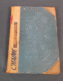 Bendigo Historical Society Inc.
Administrative record - Reports of sales by auction
Blue book with brown corners and spine, red label on spine with the title in gold letters "Reports of sales by auction". Letter "C" on spine. C'Maine on front cover. The book contains official Crown land sales documents, the papers are glued into the book. The book contains the purchasers' names, land section, allotments and price. Cover the period from 1893 to 1905.11/1/1893 to 12/03/06 written on the spine. Land sale reports 1880 written on inside cover. land sales, crown land, auctions -
Whitehorse Historical Society Inc.
Letter - Correspondence, John McClelland, 1905
Letter to John McClelland from solicitors in 1905 regarding the transfer of land to members of his family.Letter to John McClelland from solicitors in 1905 regarding the transfer of land to members of his family. Land was north and south of the railway in Tunstall (sketch).Letter to John McClelland from solicitors in 1905 regarding the transfer of land to members of his family. mcclelland, john, mcclelland family, tunstall -
Whitehorse Historical Society Inc.
Book, Aboriginal Melbourne, 1998
Subtitled 'the lost land of the Kulin people.Subtitled 'the lost land of the Kulin people. Previously published as 'The Land of the Kulin', 1985. Author's presentation copy to Ted and Valda Arrowsmith.Subtitled 'the lost land of the Kulin people. aborigines, kulin -
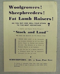 National Wool Museum
Leaflet
Subscription leaflet and application for "Stock and Land" newspaper.Subscription leaflet and application for "Stock and Land" newspaper.Geelong 848594 6/- 20/11 Prahran B893271 6/- 13/2/46agriculture - news, stock and land, woods, mr george -
 Beechworth Honey Archive
Hand-Drawn Diagram of Land by Frank Lebbell Frost September 1920
Hand-drawn diagram of land at Dookie by Frank L. Frost. Depicts plan od three allotments.hand drawn, hand-drawn, plan, land, dookie, frost, beekeeper, beechworth honey -
Tatura Irrigation & Wartime Camps Museum
Poster, Subdivision of Township Allotments
Poster depicting the land which was being sold by J S Darby on the 3 December 1890. Auctioneer was Martin Cussen and Co. Map shows location of land.Single sheet of paper, laminated. Advertising land subdivision for sale in the township of Rushworth. Being sold by Martin Cussen and Co, auctioneers for J S Darby. Shows map of land subdivision.rushworth, land subdivision, martin cussen and co, j s darby -
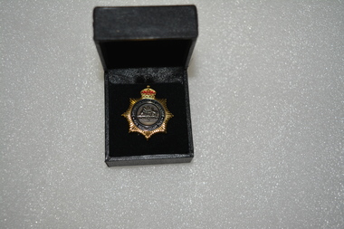 Wangaratta RSL Sub Branch
Badge - Boxed badge, 2012
Badge received by Dorothy Kiely in 2012 on the 70th anniversary of the Australian Women's Land Army. The Australian Women’s Land Army (AWLA) was formed during the Second World War to combat rising labour shortages in the farming sector. From December 1941, when Japan entered the war, the nation’s need to build up its armed forces was placed above the needs of other industries. Agricultural labour was steadily diverted to the armed services and war industry To meet the shortfall in rural labour, State and private women’s land organisations were organised, modelled on those established in Great Britain during the First and Second World Wars. A national body was formed on 27 July 1942 under the jurisdiction of the Director General of Manpower. While policy was devised by the Commonwealth Government, the organisation of the AWLA remained State-based. An extensive recruiting campaign was undertaken for new members. Most members of the existing land armies were later incorporated into the AWLA as well. Black box containing gold star shaped badge with red crown above Australian coat of arms Badge:-Australian Women's Land Army 70th Anniversary 2012 Box:- top in gold lettering 70th Anniversary of the Australian Women's Land Armyawla, ww2, dorothy kiely -
Whitehorse Historical Society Inc.
Article, Traders Trapped, 1985
Eight Businesses at Houston Shopping Centre, Middleborough Road, Box Hill.Eight Businesses at Houston Shopping Centre, Middleborough Road, Box Hill, facing rezoning of land reserved for the Healesville Freeway. Traders say they are being treated unfairly by the Road Construction Authority, owner of the land.Eight Businesses at Houston Shopping Centre, Middleborough Road, Box Hill. land use, anderson camp -
Glenelg Shire Council Cultural Collection
Photograph - Photograph - Portland Harbour, 1960-1966
Port of Portland Authority archivesFront: (no inscriptions) Back: Valuable reclaimed industrial land alongside main shipping berths at Portland (typed on sticker, centre)port of portland archives, aerial photography, portland harbour -
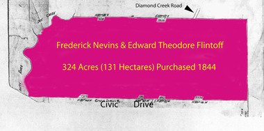 Greensborough Historical Society
Folder of documents, Flintoff - various documents, 1844_
Records the Flintoff family's ownership of parcels of land in the Greensborough area. Includes a survey plan for acquisition of land for the aqueduct 1897.Various photocopies of title documents relating to land owned by the Flintoff family in Greensborough.Mainly handwritten documents dating from early 20th century.flintoff family, land titles, greensborough, aqueduct -
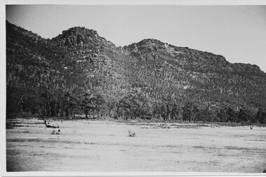 Halls Gap & Grampians Historical Society
Postcard - B/W
The Wonderland range from the Halls Gap side. the cleared land was used for grazing purposes.Photo shows peaks in background with cleared land in the foregroundPost Card Correspondence Address 122 Grampiansscenery, wonderland range -
 Ballarat Heritage Services
Photograph - Colour, Clare Gervasoni, Church Avenue, Hepburn Springs, from Bellinzona, 2004, 28/06/2004
The block of land depicted has been leveled with a huge rock barrier around the corner perimeter.Block of land on the corner of Borsa Crescent and Seventh Street.bellinzona, actea, hepburn springs, church avenue, seventh street, borsa crescent -
 Dandenong/Cranbourne RSL Sub Branch
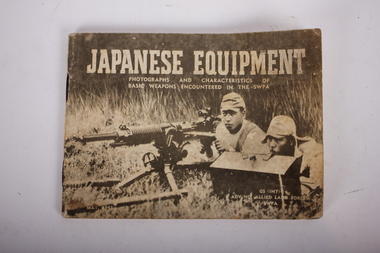
Booklet - Book, Japanese Equipment, Japanese Equipment
Recorded inside -: Pte AB Bishop ux37033 2/2nd Info Bn.Small Booklet containing Photographs and Characteristics of Basic weapons Encounted In SWPA. It is a pocket book 14cm x10cm of 50 pages detailing many items including -: flags and badges, pistols ,rifles grenades,various guns, bombs, land mines, flame thrower, tanks, tanks and mortars. Dated June 1943. Book belonged to VX37033 Andrew Bishop.GS(INT). ADV HQ ALLIED LAND FORCES SWPA NOT TO BE PUBLISHED. -
 Ringwood and District Historical Society
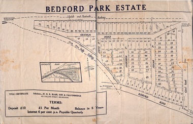
Plan - Sub-division, Bedford Park Estate, Ringwood, Victoria - 1924
Bedford Park subdivisional development did not eventuate. The land adjoining the railway line became parkland with provision for sporting facilities and the remainder was purchased by the Education Department as the site for Ringwood High School/Secondary College. Poster size land sale advertisement.Subdivision plan includes Bedford Road, Graham Road, Joyce Street, Anderson Street, and Adams Street. Solicitors - W.R.R. Blair, Son & Falconbridge, 405 Collins Street, Melbourne.