Showing 5786 items matching "location"
-
 Bendigo Historical Society Inc.
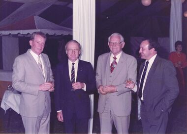
Photograph - CASTLEMAINE GAS COMPANY COLLECTION: PHOTO PEOPLE
Gas and Fuel Fashion,Food,Fitness. Four men in suits posing for photo, three are holding glasses of liquor. Lady in red dress in background. Date and location Unknown.event, social, gas & fuel fashion, food, fitness -
 Bendigo Historical Society Inc.
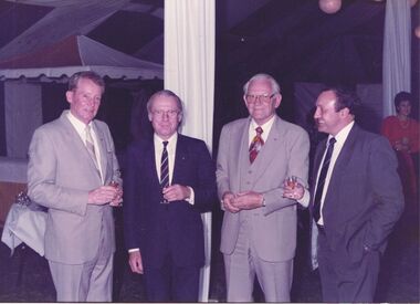
Photograph - CASTLEMAINE GAS COMPANY COLLECTION: PHOTO PEOPLE
Gas and Fuel Fashion,Food,Fitness. Four men in suits posing for photo, three are holding glasses of liquor. Lady in red dress in background. Date and location Unknown.person, group, men and woman -
 Bendigo Historical Society Inc.
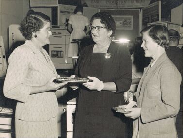
Photograph - CASTLEMAINE GAS COMPANY COLLECTION: PHOTO PEOPLE
Date and Location Unknown - 3 Unknown Ladies in a Gas Appliances Showroom - On the back a Stamp of Martin Washington The Bendigo Photographers 250 Hargreaves Street Phones 3626, 150.person, group, females -
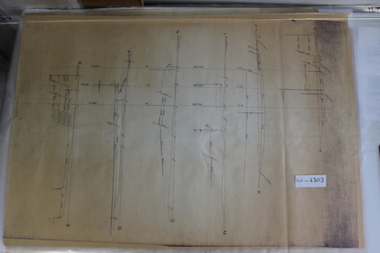
 Bendigo Historical Society Inc.
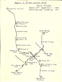
Document - BASIL MILLER COLLECTION: TRAMS - DIAGRAM BENDIGO TRAMWAY ROUTES
Hand drawn map of Bendigo tramway Routes indicating location of loops and where lines terminated. Reverse: Bottom left corner 31/2 handwritten in blue ink.person, individual, basil miller -
 Bendigo Historical Society Inc.
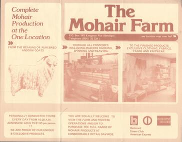
Document - BENDIGO TOURISM BROCHURES COLLECTION: THE MOHAIR FARM
Three fold brochure advertising the Mohair Farm. Complete Mohair production at one location, from the rearing of purebred Angora goats through all processes to the finished products.bendigo, business, the mohair farm -
 Port Melbourne Historical & Preservation Society
Postcard - Yachts on Hobsons Bay, 1880 - 1952
Collected by Alison KELLY when she was caretaking the Missions to Seamen Building 1987-90.One of four postcards of various locations in Port Melbourne. Hand tinted postcard - Yachts on Hobson's bay. In a 'window' with curtains either side and the words "Sunny Victoria" as a heading.piers and wharves - railway pier, piers and wharves - princes pier, parks and gardens -
Port Melbourne Historical & Preservation Society
Photograph - Various night/evening views, Port Melbourne. Bay street, Ron Laing, 1990s
Part of Ron Laing's collection of photographs recording Port Melbourne over a thirteen year period. Donated to the PMH&PS by the photographer.One of a set of 35 colour photogaphs of evening and night shots taken at various locations in Port Melbourne Bay Street looking towards the Bay with Town Hall illuminatedbuilt environment - civic, port melbourne town hall, ron laing -
Port Melbourne Historical & Preservation Society
Photograph - Various night/evening views, Port Melbourne. Corner shop, Ron Laing, 1990s
Part of Ron Laing's collection of photographs recording Port Melbourne over a thirteen year period. Donated to the PMH&PS by the photographer.One of a set of 35 colour photogaphs of evening and night shots taken at various locations in Port Melbourne Corner shop at Albert and Graham Streets. Looking towards the cityron laing, built environment - commercial -
 Port Melbourne Historical & Preservation Society
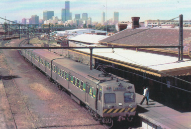
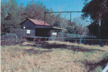
Photograph - Port Melbourne Railway Station, Glen Stuart, 1987
From set of nine colour photographs of various locations on the Port Melbourne Railway Line from Port Melbourne to Montague Stations, 1987: Port Melbourne Railway Stationtransport - railways, glen stuart -
 Port Melbourne Historical & Preservation Society
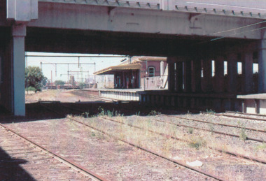
Photograph - North Port Railway Station, Port Melbourne, Glen Stuart, 1987
From set of nine colour photographs of various locations on the Port Melbourne Railway Line from Port Melbourne to Montague Stations, 1987: North Port Railway Stationtransport - railways, glen stuart -
 Coal Creek Community Park & Museum
Mine Map
6303.1 - Cross sections of Korumburra coal mining area detailing local faulting and seam location/depth, boreholes, as well as elevation & surface topography along lines of sections. -
Port Melbourne Historical & Preservation Society
Plan - Map and aerial photo of Port Melbourne, c. 1990
Notations made as a result of conversations Anne had in the early 1990s with an elderly male resident of Port Melbourne.Map and Aerial photo of Port Melbourne with handwritten annotations detailing the location of various buildings, trotting tracks, etc which previously existed in Port Melbourne (recollections only).fishermans bend -
Port Melbourne Historical & Preservation Society
Photograph - Aerial view of Port Melbourne, c. 1990
Notations made as a result of conversations Anne had in the early 1990's with an elderly male resident of Port Melbourne.Map and aerial photo of Port Melbourne with handwritten annotations detailing the location of various buildings, trotting tracks, etc which previously existed in Port Melbourne (recollections only).fishermans bend -
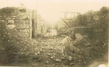 Bendigo Historical Society Inc.
Postcard - ACC LOCK COLLECTION: SEPIA PHOTO OF RUINED BUILDINGS, POSTCARD, CARTE POSTALE, 1914-1918
Postcard, WW1, Sepia photo of some ruined buildings either side of a pathway. Wooden gate in background. Location not known. G47 written in pencil on the back and stamped B148postcard, postcard, ww1, france, ruins -
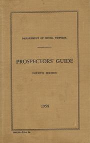 Bendigo Historical Society Inc.
Booklet - DEPARTMENT OF MINES, VICTORIA - PROSPECTORS' GUIDE FOURTH EDITION 1958
A Fourth Edition Prospectors' Guide by the Department of Mines, Victoria detailing the location and properties of minerals within the many mines of Victoria, including Bendigo and many smaller towns in 1958. -
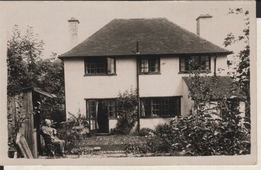 Bendigo Historical Society Inc.
Postcard - ELMA WINSLADE WELLS COLLECTION: POSTCARD OF A HOUSE
A black and white postcard depicting a house, an old man is sitting on a chair in the front garden. Date and location unknown. On the back Wishing dear Elena (?) a very happy Christmas.buildings, house, unkown -
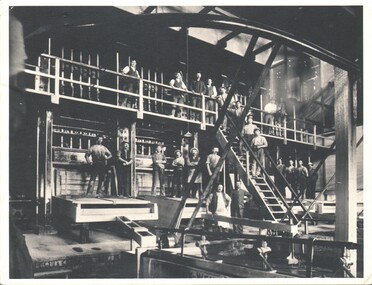 Bendigo Historical Society Inc.
Photograph - WES HARRY COLLECTION: STAMPING BATTERY, 1880's ?
Photograph of the interior of a stamping battery from an unknown mine, there are twenty three men posed in various locations, some are in front of the battery boxes, a central stairway and some are on a balconybuildings, commercial, stamping battery, stamping battery, gold production -
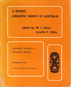 Victorian Aboriginal Corporation for Languages
Book, W J Oates, A revised linguistic survey of Australia, 1970
Lists languages under areas and language classification; records location, previous research, degree of urgency of research and assessment of total linguistic knowledge; index of variant language names.Mapslinguistics -
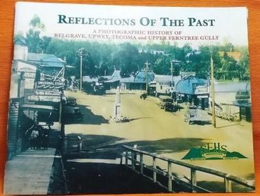 Southern Sherbrooke Historical Society Inc.
Book - Local History, Sherbrooke Foothills Historical Society, Reflections Of The Past, 1998
pp. 84, soft cover, historical photographs of Belgrave, Tecoma, Upwey and Upper Ferntree Gully. Locations, buildings, identities, with notes. Loose A4 sheet "Errata & Adenda" -
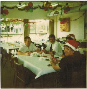 Bendigo Historical Society Inc.
Photograph - CASTLEMAINE GAS COMPANY COLLECTION: PHOTO PEOPLE
Photo of 4 People Sitting at a Table, 2 Females 2 Males the 2 Females wearing Christmas Hats. Balloons and Decorations around the Room - Date and Location UnknownPolaroidorganisation, industry, gas and fuel -
 Bendigo Historical Society Inc.
Administrative record - Soldiers Index 866, 28/06/2007
Soldiers Index 866, an alphabetic ledger of soldier's names; with CS & DS on the spine. Red and green book, with red spine and corners. Unknown duration of entries. Unknown location.soldier settlement, land sales -
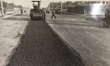 Kew Historical Society Inc
Photograph, City of Kew, Public Works, Road Construction, c.1920s
An original photograph donated to the Kew Historical Society by the City's Engineering Department before the amalgamation of Kew into the City of Boroondara in 1994.While not all of the photographs are of Studley Park, Kew or East Kew, each photo provides a fine snapshot of the work of local government engineering departments of the period. They reveal they types of labour conducted, the techniques used and the equipment and machinery in the possession of the local government authority. Public works. A photograph of a suburban street under construction using a steamroller. Neither the street nor the location has been identified. It is believed that the photograph can be dated to the 1920s. Inscription on reverse: "Road making. (?1920s cars)".steamroller, road construction building, city of kew, city of kew (engineering department) -
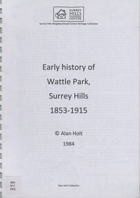 Surrey Hills Historical Society Collection
book, Early history of Wattle Park, Surrey Hills 1853-1915, 1984
Author: Alan Judge Holt amassed a significant collection of historical material related to the Surrey Hills area. Born in Moonee Ponds in 1912 to Edmund Holt and Ellen Ruby Sutton, he married Edna Jean Pallot in 1937. They lived at 62 Broughton Road, Surrey hills, had 3 sons and were strongly associated with the Surrey Hills Methodist Church. Alan was Secretary of the Victorian Lands Department and in his spare time recorded the occupancy of every property in Surrey Hills and Mont Albert at the beginning of each decade from 1890 to 1980. His collection of files and individual cards covers people, places, churches, clubs, businesses and other organisations in the area. Alan used this information to give talks and tours of the area and gifted his material to the local history collection through Jocelyn Hall.A spiral bound manuscript which includes a physical description of Wattle Park as well as covering aboriginal occupation, pastoral and timber cutting, the original purchasers and locations of neighbouring farms.back creek, wattle park, delany's paddock, cleary's paddock, blood's paddock, conran's paddock, udimore lodge, (mr) george thomas usher, (mr) orlando fenwick, phoenix grange, (mr) john filson, (mr) denis delany, (mr) john crimp, (mr) james atkinson, (mr) john lawler, (mr) henry de carle, (mr) walter craig, (mr) daniel dunn, (mr) frederick goyder, (mrs) eliza welch, metropolitan tramways, d h dureau, (mr) robert beckett, (mr) alexander gerald proudfoot, (mr) james conran, (mr) thomas blood, (mr) william smith, payne and glass -
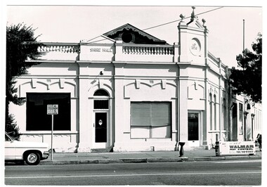 Wodonga & District Historical Society Inc
Photograph - Codling Collection 01 - Wodonga Shire Hall
Miss Olive Codling was a Foundation Member and a Life Member of the Wodonga Historical Society. Many of her prize-winning photos are held in the Society Collection. She also held a range of roles and committee positions in a wide range of Wodonga community organisations. These included the Horticultural Society, the Wodonga Arts Council, the Wodonga Camera Club and the Wodonga Lapidary Club. Wodonga Shire was created in 1876 when the colonial government agreed to ratepayers' petitions to have their part of the local government district severed from the Yackandandah Shire to form a new municipality. After meeting for 14 years in rented premises, in the Prince of Wales Hall, Wodonga Council built its first Shire Hall on the corner of High and Elgin Streets in 1890. The date on the facade of the building represents the date of the formation of the Shire.This image is significant as it documents an important building and era in the development of local government in Wodonga.Wodonga Shire office at corner of High street and Melbourne Road Built 1876 demolished 1971 . Now the location of Woolworths shopping complex. Also incorporated the Melba Theatre On facade of building: " A.D. 1876"high st wodonga, wodonga local government, shire hall wodonga -
 Bendigo Historical Society Inc.
Map - METAL DETECTING MAP WITH NOTES: GOLD AND RELIC SITES - BENDIGO KANGAROO FLAT GOLDFIELD
BHS CollectionMap of the Bendigo and Kangaroo Flat Goldfields with key to diggings, structures, locations of nuggets previously found and topographical features. Enclosed in a coloured cardboard cover with photograph of gold detector.Douglas M Stone, Outdoor Pressmap, bendigo, goldfields -
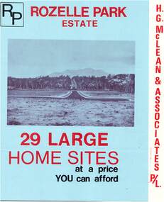 Ringwood and District Historical Society
Flyer, Subdivisional Land Sale Brochure, Rozelle Park Estate, Ringwood East, Vic. - circa 1968
Folded land subdivision sale advertisement for 29 home sites, with location map and summary of local facilities and services. Separate price list leaflet enclosed with terms of sale.Subdivision includes Wingate Avenue and Rozelle Avenue, Ringwood East. Agent - H.G. McLean & Associates Pty. Ltd., 166 Canterbury Road, Heathmont. Phone 870 3422 A/H 870 5879. -
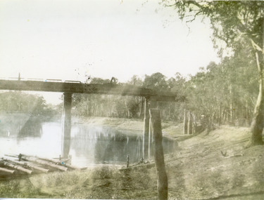 Lakes Entrance Historical Society
Photograph, 1940
Black and white photograph of a railway bridge over waterway on railway line at unknown location. Boat at edge of water has small load of log timbers across it. Victoriabridges, transport, vegetation -
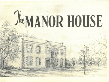 Bacchus Marsh & District Historical Society
Pamphlet, The Manor House
This pamphlet outlines the early history of the house constructed for William Bacchus in 1846-1847 and briefly describes its condition as it was in 1957. William Bacchus was one of the first European colonists to live in the area in which a township (Bacchus Marsh) was later named after him. He arrived on land occupied by the Wurundjeri and Wadawurrung peoples in 1838 and established a large sheep farm. Between 1846 and 1847 he contracted builders and other skilled workers to construct a large brick and stone two storey house. William Bacchus died in 1849. His son Henry Bacchus sold the house in 1851. For many years it was owned by the Crook family. When this pamphlet was published in 1957 the house was owned by the Lifeguard Milk Company of Bacchus Marsh. By this time the property had become derelict and was almost demolished. Around this time the Young Mens Christian Association Club in Bacchus Marsh became involved in efforts to help preserve this historic property. This pamphlet was part of those efforts. PUBLICATION DETAILS: Y's Mens Club Bacchus Marsh, Bacchus Marsh, Vic., 1957. Text written by Ronald G. Westood.Small pamphlet. Stapled softcover. 23 unnumbered pages. 11cm x 16cm. Contains photographs and cover illustration. BMDHS Location: AR/SU5 Pamphlets Box 4.non-fictionThis pamphlet outlines the early history of the house constructed for William Bacchus in 1846-1847 and briefly describes its condition as it was in 1957. William Bacchus was one of the first European colonists to live in the area in which a township (Bacchus Marsh) was later named after him. He arrived on land occupied by the Wurundjeri and Wadawurrung peoples in 1838 and established a large sheep farm. Between 1846 and 1847 he contracted builders and other skilled workers to construct a large brick and stone two storey house. William Bacchus died in 1849. His son Henry Bacchus sold the house in 1851. For many years it was owned by the Crook family. When this pamphlet was published in 1957 the house was owned by the Lifeguard Milk Company of Bacchus Marsh. By this time the property had become derelict and was almost demolished. Around this time the Young Mens Christian Association Club in Bacchus Marsh became involved in efforts to help preserve this historic property. This pamphlet was part of those efforts. PUBLICATION DETAILS: Y's Mens Club Bacchus Marsh, Bacchus Marsh, Vic., 1957. Text written by Ronald G. Westood. william bacchus, bacchus family, henry bacchus, bacchus marsh, manor house bacchus marsh, houses bacchus marsh, historic buildings bacchus marsh -
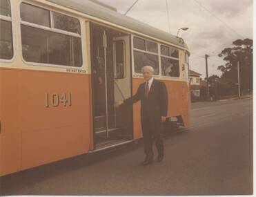 Melbourne Tram Museum
Photograph - Black & White Photograph/s, Melbourne & Metropolitan Tramways Board (MMTB), Aug. 1973
Black and white photo of Victorian Transport Minister, Mr. Vern Wilcox, board tramcar 1041 probably at the time of the formal launch in about August 1973. Location to be determined.trams, tramways, mmtb, minister for transport, 1041, tram 1041