Showing 1432 items matching "planning development"
-
 Friends of Ballarat Botanical Gardens History Group
Work on paper - Robert Clark Horticultural Centre, Outline Operation Plan 1995, post 1994-1995. [Very likely 1996]
This Outline Operation Plan was an Initial Discussion Draft (not for Broad Circulation) 1994-1995.This Outline Operation Plan shows how activities and the development of the Robert Clark Centre evolved.19 pages. 1st 3 pages are pale green. Title page has the black and green logo entitled "The Conservatory".1st page has 'Thurs. 10 Aug. 700-730pm written in biro on the top lefthand corner. Back page, top righthand corner has 43 written in biro.robert clark centre, the conservatory, robert clark horticultural centre, operation plan, ballarat botanical gardens, friends of ballarat botanical gardens, john garner, doctor, john garner collection, gardens, ballarat -
 Melton City Libraries
Document, Minns Family Reunion, 2004
"A perpetual spring in the adjacent creek provided a steady supply of fresh water to the site on which the homestead is built. Although we can not be certain of the identity of the builder, the first stage of ‘The Willows’ homestead appears to have been constructed in the mid 1850s. The house is situated on Crown Allotment No.1 (No Section), Parish of Kororoit, an allotment of 5 acres 3 roods 4 perches. Although it had surveyed the land, the Crown did not offer it for sale until 22nd November 1861, at which time it was purchased by Charles March Williams. (Although the property is directly opposite and immediately adjacent to the Township of Melton, and was sold as ‘Suburban Allotment 33’, it was situated within the Shire of Braybrook rather than the Shire of Melton until 1917.) Considerable improvements had taken place on the land prior to the Crown sale. When CM Williams purchased the allotment in November 1861 he paid £23.5.0 for the land itself, and valued the improvements at £400. Even allowing for some exaggeration by Williams, this is an extremely high valuation for improvements, and must have included a house. Some local research has claimed that in 1858 Williams had taken over the interest of a Mr Parkinson in the property, and that Parkinson built the house upon taking possession of the land c.1855. It was definitely built by 1861, when a map shows a square building on the site marked as ‘House’. The property is important in the district for its association with the establishment of the pound. The district pound had been established in 1854, when George Scarborough of Mount Cottrell (Mt Cottrell Road, south of Greigs Road) was appointed pound-keeper. Scarborough resigned in 1857. The pound was moved to Melton following agitation from local farmers and Charles March Williams appointed pound-keeper on 26th April 1858. Williams, the son of a doctor, had been born in London. Reminiscences of local residents of the time, as recorded in the Express newspaper, note Williams’ success in breeding horses on the property. Sales of up to 60 guineas were noted. Whether this was from Williams’s own stock or from unclaimed pound stock is not made clear. Williams appeared before a government inquiry in 1860 and advocated registration of all stock brands in the State. Williams died in 1862 leaving a widow, Catherine, and five living children aged 15 years to five months. At the time of his death Williams had entered negotiations with one Matthew Devenish and had a mortgage of £100 on allotments 1 and 2, Parish of Kororoit. Catherine Williams was appointed pound-keeper on 2 September 1863, with her eldest son Charles as her assistant. Her tenure was short for on 22nd March 1864 George Minns senior paid Matthew Devenish £135 for allotments 1 and 2 Parish of Kororoit (considerably less than Williams had claimed the property was worth in 1861) and on the same day paid William Tullidge £45 for the adjoining allotments 3 and 4. In April 1867, James Ebden Minns, the newly married son of George senior became the owner of The Willows property having entered into a mortgage arrangement with his father to the extent of £200. At the time George Minns was residing in Kaarimba having left Melton in 1867 for a short trip to England and upon his return having taken up a selection in the Kaarimba district with his son Frederick who had a hotel licence there. James paid out the mortgage on 2-1-1873. James Minns was appointed pound-keeper in 1872; in 1885 the pound was moved elsewhere and Minns purchased the old pound site and added it to his farm. The Willows residence underwent a major change about this time. A two room extension, similar in style but with a lower elevation was added to the original rear of the house with a chimney matching the distinctive originals. Window arrangements did not match the original but became a feature of the façade when the new addition became the front of the building. Six buttresses were attached to the east and west walls of the old building, two to the south wall and the whole rendered with mortar to give the appearance of dressed stonework around the windows. Galvanized iron was placed over the shingles and a verandah added on three sides. By 1876 The Willows was the homestead for a thriving mixed farm of 340 acres of which 156 was rented from a H. Ruck. In October of that year the Australasian travelling reporter visited and reported on the property. In common with the nearly every other property in the district the farm had ‘recently’ (generally within the last two years) abandoned cultivation of crops, and turned over completely to cattle pasture. Butter making was the principal occupation of the farm, which had about 50 head of cattle, a large proportion of which were milking cows. The reporter also noted that a ‘large number of pigs are kept upon this farm and are found to be very profitable stock’. Their manure was used in an orchard and garden in which ‘large quantities of lucerne and prairie grass are grown for the use of stock when ordinary feed is scarce’. Two bores attached to deep brick lined wells supplied water for the house in addition to the farm. A commodious timber barn and necessary sheds had also been constructed. Access to the property was improved following the construction of the bluestone ford across the creek c.1887, when the recreation ground came into use. Prior to this date it may have been that the crossing referred to as ‘Mr Minns bridge’ was used. This appears to have been a flimsy structure and has but two references in Council reports in the Melton Express in the 1880’s. It is believed that in the late 1890’s a timber building was added near the rear of the building to house a kitchen, ablutions and laundry rooms and rooms for seasonal workers. This was attached to the house by means of a trellised walkway using the original front entry to the house (long since the back door). A photograph of this building appears in a local history of Melton. This was demolished in recent decades during the period when the house was tenanted (after the Minns family had left). James Minns son, George, took over the property following his marriage to Alice Walsh in 1903. James and Caroline moved into a house on the former JH Games property at the eastern end of Henry Street. George held the position of Shire Secretary for Melton for 40 years. He was a most prominent member of the community being Secretary to, among others, the Melton Coursing Club, the Shooting Club and the Cemetery Trust. He also rode with the hunting parties who sported across the Plains and were entertained at Mount Kororoit. George and Alice had one son, Norman who followed his father into local government and became Secretary of the Shire of Werribee completing a record term in this position. George retired to Werribee in 1951, where he died in 1965. The National Trust records note that James Ebden Minns and his sons were ‘leading men of the district, Justices of the Peace, and Shire Councillors’. It claims that Sir Thomas Bent was a frequent visitor. The Willows passed into the hands of George’s grandson, Bruce Minns and the property was let for a number of years. In the 1960s it became vacant and was subject to vandalism. Major structural problems arose with the part demolition of the roof, the loss of windows and doors and holes dug into and under the floorboards. The outbuildings were particularly targeted. Following widespread public support, the Shire of Melton purchased the house, with 3.75 acres of land, in 1972. In 1975 the Shire of Melton and the Melton and District Historical Society were successful in nominating the building for National Trust classification, and then the Australian Heritage Commission’s Register of the National Estate. The AHC particularly noted its ‘townscape importance’. It was envisaged that the farmhouse would form ‘a picturesque centrepiece to Melton’s planned … historical park, along with Dunvegan bluestone cottage … and similar structures as they become available.’ In a time of great Melton’s ‘satellite city’ development the Council spelt out its broader vision in its submission to the AHC: ‘Melton is destined to become, by the end of the present century, a city of between 75,000 and 100,000 people. Significant relics of the past, such as ‘The Willows’, regrettably will be rare in that situation. It is essential that sufficient tangible links with Melton’s pioneering days remain to promote in the new community a sense of history and continuity’. Under the direction of ‘The Willows’ Restoration Committee and consultant architect John Hitch, all outbuildings, with the exception of the garage and toilet, were demolished and the dwelling house restored. Finances were provided by the Shire of Melton and the National Estate Grants Program, and considerable amount of voluntary labour was provided by the local community. The orchard was removed, and remaining wooden buildings were relocated to provide an open vista for visitors to the Park. The property was furnished with donations from district families keen to preserve this example of pioneer life in the area. The Willows became the headquarters of the Melton and District Historical Society". Invitation to the family reunion at the Willowslocal identities, pioneer families -
 Melbourne Legacy
Document, Letter from Legatee Donovan Joynt, 1980s
A letter about the Shrine that was sent by Legatee Donovan Joynt to the President. The date is unknown. He outlines concern that buildings that are proposed along St Kilda road will block the view of the Shrine from different perspectives. The original plans of the Shrine being at the Domain site emphasised that it would be visible on many axis, including from a ship passing through the heads of Port Phillip Bay. He accuses Legacy of being lax in fighting for the original plans being upheld and fighting inappropriate development. Was in a binder of documents that is passed from an outgoing President to the incoming President. It is primarily from the 1930s to 1990s. Most documents are being catalogued separately.A record of a concern by a Legatee about the sanctity of the Shrine being encroached upon by inappropriate buildings nearby.White A4 paper x 2 pages with black type of an undated letter from Legatee Donovan to the President.Signed in pencil 'Donovan Joynt'.shrine of remembrance, donovan joynt -
 Camberwell Historical Society
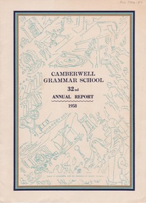
Booklet (Item), Camberwell Grammar School, Camberwell Grammar School 32nd Annual Report 1958, 1958
... Development of Master Plan diagram, and Headmaster T.H. Timpson's..., Interim Development of Master Plan diagram, and Headmaster T.H ...camberwell, school -
Camberwell Historical Society
Document (Item) - Report, City of Boroondara, City of Boroondara Annual Report 1998/1999, 1999
boroondara -
Harcourt Valley Heritage & Tourist Centre
Book, Harcourt Speaks, 2009
'Harcourt Speaks' represents the collaboration of a group of local orchardists, farmers, growers and local community who worked together to gather photos and stories of strength, cohesion and innovation around the impact of relentless drought and changing climatic conditions. This was a drought assistance project supported by the Mount Alexander Shire Council and the Victorian Government Dept of Community Planning and Development.Project Facilitator was Phillippa Gregory and Photography Community Development was provided by Deanna Neville.Provides a cross-section of the working adults of a rural community as they faced the grim reality of extended drought with attendant restrictions on the use of irrigation water and the consequent near disastrous impact on horticulture in this famed horticultural valley. Each photo has a brief story attached. The captions tell how this community responded by acceptance and innovation, using words like "we adapted' 'we were innovative' 'new directions chosen' 'resilience' 'optimistic'.This project is significant in that it depicts a community that, faced with real adversity, was not weakly submissive, nor crushed, but made the best of it.It has significance as an example of a creative response to a prolonged negative situationSixteen page, spiral bound, A4 'landscape'book with coloured title page, with 31 coloured photographs.Harcourt Speaks -
 Wodonga & District Historical Society Inc
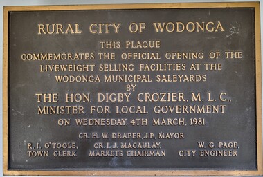
Plaque - Commemoration of the Opening of Liveweight Sales Wodonga Municipal Saleyards 1981
This plaque commemorates the official opening of the liveweight selling facilities at the Wodonga Municipal Saleyards, named the W. G. Page Saleyards, in 1980. Liveweight selling usually involves a curfew where cattle have to be at the saleyard by a specific time before the sale in order for them to be weighed prior to auction. Cattle that do not make the curfew time are sold on a $/head basis. The last sales at this facility took place in February 2015 before being replaced by the privately-run Barnawartha North's Northern Victoria Livestock Exchange. William George Page was Shire and City Engineer in Wodonga from 1965 until 1989. When he arrived the Shire of Wodonga had a population of 17,000 people. In 1966 Wodonga was selected as a city for special growth assistance. In 1972 Bill Page presented a new Town Plan to the Wodonga Council. Over the ensuing years he dedicated himself to bring this plan to fruition. He often had to argue and campaign with the Albury-Wodonga Corporation to push for the interests of development in Wodonga. This included winning a planning appeal to allow the saleyards to be relocated to Bandiana on the outskirts of Wodonga. Bill Page retired on health grounds in July 1989. The Council honoured him with a farewell dinner and renamed the saleyards at Bandiana the W.G. Page Saleyards in his honour.The Mayor , Cr Valentina Gillard, said "Every development in Wodonga in the past 24 years has a bit of Bill Page in it". William Page died 3 months later at 58 years old.A bronze forged metal plaque with detailed inscription. Bolts to fix plaque to the wall are still attached.RURAL CITY OF WODONGA / THIS PLAQUE/ COMMEMORATES THE OFFICIAL OPENING OF THE/ LIVEWEIGHT SELLING FACILITIES AT / THE WODONGA MUNICIPAL SALEYARDS /BY/THE HON. DIGBY CROZIER, M.L.C., / MINISTER FOR LOCAL GOVERNMENT/ ON WEDNESDAY, 4TH MARCH, 1981 CR. H. W, DRAPER, J.P. MAYOR R. I. O'TOOLE TOWN CLERK , CR. I. J. MACAULAY MARKETS CHAIRMAN W. G. PAGE CITY ENGINEERlivestock sales wodonga, liveweight cattle sales, municipal saleyards wondonga -
 Wodonga & District Historical Society Inc
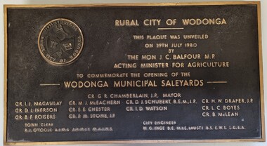
Plaque - Opening of Wodonga Municipal Saleyards 1980
This plaque commemorates the opening of the Wodonga Municipal Saleyards, named the W. G. Page Saleyards, in 1980. The last sales at this facility took place in February 2015 before being replaced by the privately-run Barnawartha North's Northern Victoria Livestock Exchange. William George Page was Shire and City Engineer in Wodonga from 1965 until 1989. When he arrived the Shire of Wodonga had a population of 17,000 people. In 1966 Wodonga was selected as a city for special growth assistance. In 1972 Bill Page presented a new Town Plan to the Wodonga Council. Over the ensuing years he dedicated himself to bring this plan to fruition. He often had to argue and campaign with the Albury-Wodonga Corporation to push for the interests of development in Wodonga. This included winning a planning appeal to allow the saleyards to be relocated to Bandiana on the outskirts of Wodonga. Bill Page retired on health grounds in July 1989. The Council honoured him with a farewell dinner and renamed the saleyards at Bandiana the W.G. Page Saleyards in his honour.The Mayor , Cr Valentina Gillard, said "Every development in Wodonga in the past 24 years has a bit of Bill Page in it". William Page died 3 months later at 58 years old.This plaque commemorates an important centre in the development and support of the livestock industry around Wodonga.A bronze plaque bearing the symbol of the Rural City of Wodonga in the upper left corner and an inscription to commemorate the opening of the Wodonga Municipal Saleyards. It includes a detailed inscription.RURAL CITY OF WODONGA / THIS PLAQUE WAS UNVEILED / ON 29TH JULY 1980 / BY /THE HON. J. C. BALFOUR M.P. / ACTING MINISTER FOR AGRICULTURE /TO COMMEMORATE THE OPENING OF THE / WODONGA MUNICIPAL SALEYARDS CR. G. R. CHAMBERLAIN, J.P. MAYOR CR. I . J. MACAULAY CR. M. J. McEACHERN CR. D. I. SCHUBERT, B'E'N', J.P CR. H. W. DRAPER, J.P. CR. D.J .IVERSON CR. E. E. CHESTER CR I. D. WATSON CR. L. C. BOYES CR. B. F. ROGERS CR. P. M. STONE. J.P CR. B. McLEAN TOWN CLERK R. I. O"TOOLE A.I.M.A., A.R.M.I.T, M.A.I.H.S CITY ENGINEER W. G. PAGE, B.E, M.I.E (AUST) B.S .E.W.S L. G. E. A saleyards wodonga, w. g. page saleyards, livestock sales wodonga -
 Wodonga & District Historical Society Inc
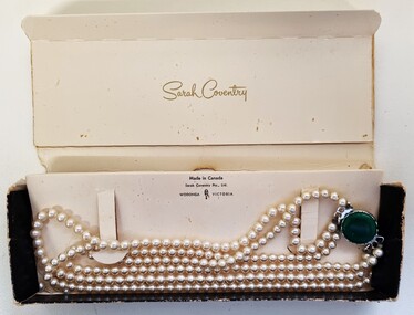
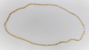
Decorative object - Sarah Coventry Pearl Necklace, c1980
Historical information Sarah Coventry Pty. Ltd. was a North American jewellery company that was established in 1949 by the Stuart family as part of Emmons Jewelry, Inc. It began operations in England and Australia in 1968, and in Australia it moved from Carlton in Melbourne to Wodonga in 1969. The premises were originally on High St. in Wodonga, but a new warehouse was built in Melbourne Rd. later in 1969. It was a direct selling jewellery business using a party-plan model similar to Tupperware and Avon. The sales reps or 'Hostesses' were provided with jewellery samples in demonstration kits, which they displayed at jewellery parties in their homes. The designs for jewellery such as brooches, necklaces, earrings, chokers and bracelets were purchased from freelance designers and jewellery manufacturers rather than in-house designers. In 1979 Sarah Coventry Pty. Ltd. in Wodonga was bought by three Australian businessmen, including Wodonga local Jim Sawyer, and continued to sell jewellery under the name "Sargem Pty. Ltd”, for several more years in the 1980s.As part of the Sarah Coventry collection, the necklace has local significance with the decentralised commercial development of regional centres such as Wodonga in NE Victoria, as well as national and international significance from the perspective of social and economic developments for women after World War II. The direct selling party-plan business model Sarah Coventry was based on is also considered the first of its kind for jewellery.Necklace with three strands of faux pearls and a large faux green stone at the silver toned metal clasp on the front, and a large faux pearl at the clasp on the back. includes box featuring Sarah Coventry brandingOn outside of box : "Sarah Coventry® /PTY. LTD. /WODONGA, VICTORIA On inside of lid: "Sarah Coventry" On internal cardboard mounting: "Made in Canada / Sarah Coventry Pty., Ltd. / WODONGA (SC) VICTORIAsarah coventry, costume jewellery, industry wodonga -
 Wodonga & District Historical Society Inc
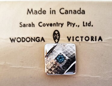
Decorative object - Sarah Coventry Tie Pin
Historical information Sarah Coventry Pty. Ltd. was a North American jewellery company that was established in 1949 by the Stuart family as part of Emmons Jewelry, Inc. It began operations in England and Australia in 1968, and in Australia it moved from Carlton in Melbourne to Wodonga in 1969. The premises were originally on High St. in Wodonga, but a new warehouse was built in Melbourne Rd. later in 1969. It was a direct selling jewellery business using a party-plan model similar to Tupperware and Avon. The sales reps or 'Hostesses' were provided with jewellery samples in demonstration kits, which they displayed at jewellery parties in their homes. The designs for jewellery such as brooches, necklaces, earrings, chokers and bracelets were purchased from freelance designers and jewellery manufacturers rather than in-house designers. In 1979 Sarah Coventry Pty. Ltd. in Wodonga was bought by three Australian businessmen, including Wodonga local Jim Sawyer, and continued to sell jewellery under the name "Sargem Pty. Ltd”, for several more years in the 1980s. The "Aristocrat" line was first released in Canada in 1969 for several years. It was distributed from the outlet at Sarah Coventry Park, Wodonga.As part of the Sarah Coventry collection, the tie pin has local significance with the decentralised commercial development of regional centres such as Wodonga in NE Victoria, as well as national and international significance from the perspective of social and economic developments for women after World War II. The direct selling party-plan business model Sarah Coventry was based on is also considered the first of its kind for jewellery.A small square tie pin of silvertone plated metal with an ice blue rhinestone in the centre. A short chain and clip are attached. A small diamond shape has the "SarCov" brand on the back. The pin is in its original packaging of a cardboard box with clear central oval on the front. The back of the box bears the Sarah Coventry branding as does the internal card.On internal mounting card: "Made in Canada/ Sarah Coventry Pty. Ltd / WODONGA (SC) VICTORIA" On back of box: "Sarah Coventry® PTY. LTD / SARAH COVENTRY PARK/ WODONGA, VICTORIA / PTD IN AUST"sarah coventry wodonga, men's fashion accessories, costume jewellery -
 Wodonga & District Historical Society Inc
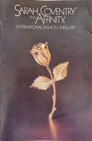
Booklet - Sarah Coventry Affinity Range Catalogue 1982
Historical information Sarah Coventry Pty. Ltd. was a North American jewellery company that was established in 1949 by the Stuart family as part of Emmons Jewelry, Inc. It began operations in England and Australia in 1968, and in Australia it moved from Carlton in Melbourne to Wodonga in 1969. The premises were originally on High St. in Wodonga, but a new warehouse was built in Melbourne Rd. later in 1969. It was a direct selling jewellery business using a party-plan model similar to Tupperware and Avon. The sales reps or 'Hostesses' were provided with jewellery samples in demonstration kits, which they displayed at jewellery parties in their homes. The designs for jewellery such as brooches, necklaces, earrings, chokers and bracelets were purchased from freelance designers and jewellery manufacturers rather than in-house designers. In 1979 Sarah Coventry Pty. Ltd. in Wodonga was bought by three Australian businessmen, including Wodonga local Jim Sawyer, and continued to sell jewellery under the name "Sar*gem Pty. Ltd”, for several more years in the 1980s, along with a new range of fashion jewellery, Affinity. This catalogue was produced by Sar*gem Pty Ltd in 1982As part of the Sarah Coventry collection, the catalogue has local significance connected to the decentralised commercial development of regional centres such as Wodonga in NE Victoria, as well as national and international significance from the perspective of social and economic developments for women after World War II. The direct selling party-plan business model Sarah Coventry was based on is also considered the first of its kind for jewellery. A coloured catalogue promoting the Affinity Jewellery line released in 1982. The back cover features a fundraising campaign for the Guide Dog Association. Business contact details on the back cover use the company name "Sar*Gem Pty Ltd", Hume Highway Wodonga.sarah coventry, sarah coventry wodonga, sarah coventry affinity -
 Wodonga & District Historical Society Inc
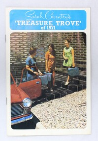
Booklet - Recruiting awards brochure for Sarah Coventry jewellery sales, "Sarah Coventry's 'Treasure Trove' of 1971"
Sarah Coventry Pty. Ltd. was a North American jewellery company that was established in 1949 by the Stuart family as part of Emmons Jewelry, Inc. It began operations in England and Australia in 1968, and in Australia it moved from Carlton in Melbourne to Wodonga in 1969. The premises were originally on High St. in Wodonga, but a new warehouse was built in Melbourne Rd. later in 1969. It was a direct selling jewellery business using a party-plan model similar to Tupperware and Avon. The sales reps or 'Hostesses' were provided with jewellery samples in demonstration kits, which they displayed at jewellery parties in their homes. The designs for jewellery such as brooches, necklaces, earrings, chokers and bracelets were purchased from freelance designers and jewellery manufacturers rather than in-house designers. In 1979 Sarah Coventry Pty. Ltd. in Wodonga was bought by three Australian businessmen, including Wodonga local Jim Sawyer, and continued to sell jewellery under the name "Sargem Pty. Ltd”, for several more years in the 1980s. The colour booklet for Sarah Coventry Pty. Ltd. recruitment awards for jewellery sales has local significance as part of the decentralised commercial development of regional centres such as Wodonga in NE Victoria. As part of the Sarah Coventry collection, the booklet has national and international significance from the perspective of social and economic developments for women after World War II. The direct selling party-plan business model Sarah Coventry was based on is also considered the first of its kind for jewellery.Colour booklet with the awards that sales reps or "hostesses" for Sarah Coventry jewellery could earn dated to 1971. Twelve pages of colour photos of the different types of awards, with colour drawings and the text in black. The colour photo on the front cover of the booklet appears to show the front steps to the Sarah Coventry warehouse in Wodonga, built in 1969.sarah coventry, jewellery, wodonga, costume jewellery, vintage fashion jewellery -
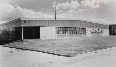 Wodonga & District Historical Society Inc
Photograph - The Sarah Coventry Pty. Ltd. building in Wodonga, Victoria, c. 1969
Sarah Coventry Pty. Ltd. was a North American jewellery company that was established in 1949 by the Stuart family as part of Emmons Jewelry, Inc. It began operations in England and Australia in 1968, and in Australia it moved from Carlton in Melbourne to Wodonga in 1969. The premises were originally on High St. in Wodonga, but a new warehouse was built in Melbourne Rd. later in 1969. It was a direct selling jewellery business using a party-plan model similar to Tupperware and Avon. The sales reps or 'Hostesses' were provided with jewellery samples in demonstration kits, which they displayed at jewellery parties in their homes. The designs for jewellery such as brooches, necklaces, earrings, chokers and bracelets were purchased from freelance designers and jewellery manufacturers rather than in-house designers. In 1979 Sarah Coventry Pty. Ltd. in Wodonga was bought by three Australian businessmen, including Wodonga local Jim Sawyer, and continued to sell jewellery under the name "Sargem Pty. Ltd”, for several more years in the 1980s. The black and white photograph of the 1969 Sarah Coventry Pty. Ltd. warehouse in Wodonga has local significance as part of the decentralised commercial development of regional centres such as Wodonga in NE Victoria. As part of the Sarah Coventry collection, the photograph has national and international significance from the perspective of social and economic developments for women after World War II. The direct selling party-plan business model it was based on is also considered the first of its kind for jewellery.Black and white photographic print of the outside of the Sarah Coventry Pty. Ltd. building in Wodonga, Victoria. It was built in 1969 at Sarah Coventry Park, Hume Highway, Wodonga.The name "Sarah Coventry" is on the front wall of the building in the photo.sarah coventry, jewellery, wodonga, costume jewellery, vintage fashion jewellery -
 Wodonga & District Historical Society Inc
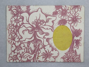
Functional object - Sarah Coventry jewellery polishing cloth, c.1970s
Sarah Coventry Pty. Ltd. was a North American jewellery company that was established in 1949 by the Stuart family as part of Emmons Jewelry, Inc. It began operations in England and Australia in 1968, and in Australia it moved from Carlton in Melbourne to Wodonga in 1969. The premises were originally on High St. in Wodonga, but a new warehouse was built in Melbourne Rd. later in 1969. It was a direct selling jewellery business using a party-plan model similar to Tupperware and Avon. The sales reps or 'Hostesses' were provided with jewellery samples in demonstration kits, which they displayed at jewellery parties in their homes. The designs for jewellery such as brooches, necklaces, earrings, chokers and bracelets were purchased from freelance designers and jewellery manufacturers rather than in-house designers. In 1979 Sarah Coventry Pty. Ltd. in Wodonga was bought by three Australian businessmen, including Wodonga local Jim Sawyer, and continued to sell jewellery under the name "Sargem Pty. Ltd”, for several more years in the 1980s. As part of the Sarah Coventry collection, the jewellery polishing cloth has local significance with the decentralised commercial development of regional centres such as Wodonga in NE Victoria, as well as national and international significance from the perspective of social and economic developments for women after World War II. The direct selling party-plan business model Sarah Coventry was based on is also considered the first of its kind for jewellery.Sarah Coventry Pty. Ltd. yellow jewellery polishing cloth in a light-coloured paper envelope with pink floral designs on the front and back, as well as text on the back. Oval cut out on the front surface to show the yellow polishing cloth."Sarah Coventry / Sarah Conventry, Inc. Newark, New York 14593 Copyright 1975 / A Care Cloth to keep your Sarah Coventry jewelry looking lovely. / A quick polishing will remove dust and fingerprints. / Enjoy Sarah Coventry at its finest."sarah coventry, jewellery, wodonga, costume jewellery, vintage fashion jewellery, jewellery polishing cloths -
 Wodonga & District Historical Society Inc
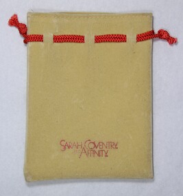
Functional object - Faux suede draw string pouch for Sarah Coventry and Affinity jewellery, c. 1980s
Sarah Coventry Pty. Ltd. was a North American jewellery company that was established in 1949 by the Stuart family as part of Emmons Jewelry, Inc. It began operations in England and Australia in 1968, and in Australia it moved from Carlton in Melbourne to Wodonga in 1969. The premises were originally on High St. in Wodonga, but a new warehouse was built in Melbourne Rd. later in 1969. It was a direct selling jewellery business using a party-plan model similar to Tupperware and Avon. The sales reps or 'Hostesses' were provided with jewellery samples in demonstration kits, which they displayed at jewellery parties in their homes. The designs for jewellery such as brooches, necklaces, earrings, chokers and bracelets were purchased from freelance designers and jewellery manufacturers rather than in-house designers. In 1979 Sarah Coventry Pty. Ltd. in Wodonga was bought by three Australian businessmen, including Wodonga local Jim Sawyer, and continued to sell jewellery under the name "Sargem Pty. Ltd”, for several more years in the 1980s. The faux suede jewellery pouch has local significance as part of the Sarah Coventry collection and the decentralised commercial development of regional centres such as Wodonga in NE Victoria, as well as national and international significance from the perspective of social and economic developments for women after World War II. The direct selling party-plan business model Sarah Coventry was based on is also considered the first of its kind for jewellery.Small light brown/beige, faux suede jewellery pouch with a red draw string and the brand names "Sarah Coventry" and "Affinity" on the front."SARAH COVENTRY. / AND / AFFINITY."sarah coventry, jewellery, wodonga, costume jewellery, vintage fashion jewellery, jewellery pouch -
 Wodonga & District Historical Society Inc
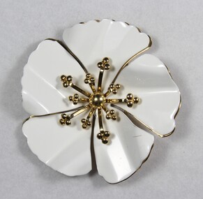
Decorative object - Brooch from the Sarah Coventry jewellery range, c. 1970s - 1980s
Sarah Coventry Pty. Ltd. was a North American jewellery company that was established in 1949 by the Stuart family as part of Emmons Jewelry, Inc. It began operations in England and Australia in 1968, and in Australia it moved from Carlton in Melbourne to Wodonga in 1969. The premises were originally on High St. in Wodonga, but a new warehouse was built in Melbourne Rd. later in 1969. It was a direct selling jewellery business using a party-plan model similar to Tupperware and Avon. The sales reps or 'Hostesses' were provided with jewellery samples in demonstration kits, which they displayed at jewellery parties in their homes. The designs for jewellery such as brooches, necklaces, earrings, chokers and bracelets were purchased from freelance designers and jewellery manufacturers rather than in-house designers. In 1979 Sarah Coventry Pty. Ltd. in Wodonga was bought by three Australian businessmen, including Wodonga local Jim Sawyer, and continued to sell jewellery under the name "Sargem Pty. Ltd”, for several more years in the 1980s. As part of the Sarah Coventry collection, the brooch has local significance with the decentralised commercial development of regional centres such as Wodonga in NE Victoria, as well as national and international significance from the perspective of social and economic developments for women after World War II. The direct selling party-plan business model Sarah Coventry was based on is also considered the first of its kind for jewellery.Gold-toned metal brooch from the Sarah Coventry Pty. Ltd. jewellery range in the shape of a flower. Two layers of petals with the upper one white and the lower one gold-toned. "© SARAH COV. / MADE IN CANADA" on the back surface.sarah coventry, jewellery, wodonga, costume jewellery, vintage fashion jewellery, brooch, brooches -
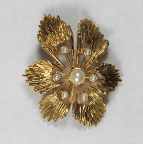 Wodonga & District Historical Society Inc
Functional object - Brooch from the Sarah Coventry jewellery range, c. 1970s - 1980s
Sarah Coventry Pty. Ltd. was a North American jewellery company that was established in 1949 by the Stuart family as part of Emmons Jewelry, Inc. It began operations in England and Australia in 1968, and in Australia it moved from Carlton in Melbourne to Wodonga in 1969. The premises were originally on High St. in Wodonga, but a new warehouse was built in Melbourne Rd. later in 1969. It was a direct selling jewellery business using a party-plan model similar to Tupperware and Avon. The sales reps or 'Hostesses' were provided with jewellery samples in demonstration kits, which they displayed at jewellery parties in their homes. The designs for jewellery such as brooches, necklaces, earrings, chokers and bracelets were purchased from freelance designers and jewellery manufacturers rather than in-house designers. In 1979 Sarah Coventry Pty. Ltd. in Wodonga was bought by three Australian businessmen, including Wodonga local Jim Sawyer, and continued to sell jewellery under the name "Sargem Pty. Ltd”, for several more years in the 1980s. As part of the Sarah Coventry collection, the brooch has local significance with the decentralised commercial development of regional centres such as Wodonga in NE Victoria, as well as national and international significance from the perspective of social and economic developments for women after World War II. The direct selling party-plan business model Sarah Coventry was based on is also considered the first of its kind for jewellery.Gold-toned metal brooch from the Sarah Coventry Pty. Ltd. with one large central faux pearl surrounded by six smaller faux pearls.'SARAH COV" at the top and "MADE / IN/ CANADA" at the bottom of the back surface.sarah coventry, jewellery, wodonga, costume jewellery, vintage fashion jewellery, brooch, brooches, sawyer -
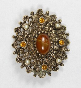 Wodonga & District Historical Society Inc
Decorative object - Brooch from the Sarah Coventry jewellery range, c. 1970s -1980s
Sarah Coventry Pty. Ltd. was a North American jewellery company that was established in 1949 by the Stuart family as part of Emmons Jewelry, Inc. It began operations in England and Australia in 1968, and in Australia it moved from Carlton in Melbourne to Wodonga in 1969. The premises were originally on High St. in Wodonga, but a new warehouse was built in Melbourne Rd. later in 1969. It was a direct selling jewellery business using a party-plan model similar to Tupperware and Avon. The sales reps or 'Hostesses' were provided with jewellery samples in demonstration kits, which they displayed at jewellery parties in their homes. The designs for jewellery such as brooches, necklaces, earrings, chokers and bracelets were purchased from freelance designers and jewellery manufacturers rather than in-house designers. In 1979 Sarah Coventry Pty. Ltd. in Wodonga was bought by three Australian businessmen, including Wodonga local Jim Sawyer, and continued to sell jewellery under the name "Sargem Pty. Ltd”, for several more years in the 1980s. As part of the Sarah Coventry collection, the brooch has local significance with the decentralised commercial development of regional centres such as Wodonga in NE Victoria, as well as national and international significance from the perspective of social and economic developments for women after World War II. The direct selling party-plan business model Sarah Coventry was based on is also considered the first of its kind for jewellery.Oval gold-toned metal brooch from the Sarah Coventry jewellery range, with a central brown faux stone surrounded by four small faux pearl inlays and four small circular brown faceted glass inlays."©SARAH COV / MADE IN / CANADA" raised maker mark on the back surface.sarah coventry, jewellery, wodonga, costume jewellery, vintage fashion jewellery, brooch, brooches -
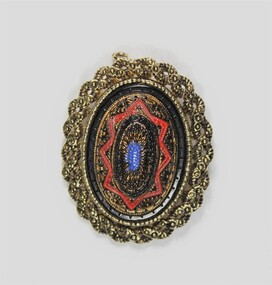 Wodonga & District Historical Society Inc
Decorative object - Brooch from the Sarah Coventry jewellery range, "Old Vienna", c. 1970s - 1980s
Sarah Coventry Pty. Ltd. was a North American jewellery company that was established in Wodonga in 1969. The premises were originally on High St., but a new warehouse was built in Melbourne Rd. later in 1969. The North American parent company of the Stuart family started Sarah Coventry Pty. Ltd. in 1949, as part of Emmons Jewelry, Inc. It was a direct selling jewellery business using a party-plan model similar to Tupperware and Avon. The sales reps or 'Hostesses' were provided with jewellery samples in demonstration kits, which they displayed at jewellery parties in their homes. The designs for jewellery such as brooches, necklaces, earrings, chokers and bracelets were purchased from freelance designers and jewellery manufacturers rather than in-house designers. In 1979, Sarah Coventry Pty. Ltd. in Wodonga was bought as an Australian business venture, which included Wodonga local Jim Sawyer, and continued to sell jewellery under the name "Sargem Pty. Ltd”, for several more years in the 1980s. The brooch has local significance as part of the decentralised commercial development of regional centres such as Wodonga in NE Victoria. As part of the Sarah Coventry collection, the brooch has national and international significance from the perspective of social and economic developments for women after World War II. The direct selling party-plan business model Sarah Coventry was based on is also considered the first of its kind for jewellery.Oval brooch in gold toned metal with red blue and black enamel (?) inlay."©SARAHCOV" on the back surfacesarah coventry, jewellery, wodonga, costume jewellery, vintage fashion jewellery, brooch, brooches -
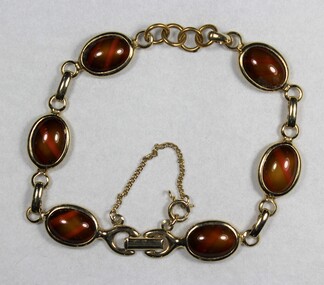 Wodonga & District Historical Society Inc
Decorative object - Bracelet from the Sarah Coventry jewellery range, "Wood Nymph" collection, c. 1970s - 1980s
Sarah Coventry Pty. Ltd. was a North American jewellery company that was established in 1949 by the Stuart family as part of Emmons Jewelry, Inc. It began operations in England and Australia in 1968, and in Australia it moved from Carlton in Melbourne to Wodonga in 1969. The premises were originally on High St. in Wodonga, but a new warehouse was built in Melbourne Rd. later in 1969. It was a direct selling jewellery business using a party-plan model similar to Tupperware and Avon. The sales reps or 'Hostesses' were provided with jewellery samples in demonstration kits, which they displayed at jewellery parties in their homes. The designs for jewellery such as brooches, necklaces, earrings, chokers and bracelets were purchased from freelance designers and jewellery manufacturers rather than in-house designers. In 1979 Sarah Coventry Pty. Ltd. in Wodonga was bought by three Australian businessmen, including Wodonga local Jim Sawyer, and continued to sell jewellery under the name "Sargem Pty. Ltd”, for several more years in the 1980s. As part of the Sarah Coventry collection, the bracelet has local significance with the decentralised commercial development of regional centres such as Wodonga in NE Victoria, as well as national and international significance from the perspective of social and economic developments for women after World War II. The direct selling party-plan business model Sarah Coventry was based on is also considered the first of its kind for jewellery.Gold toned metal bracelet with six small brown oval faux stones"SARAH COV" on the back of the clasp.sarah coventry, jewellery, wodonga, costume jewellery, vintage fashion jewellery, bracelet, bracelets -
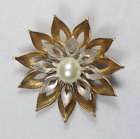 Wodonga & District Historical Society Inc
Decorative object - Brooch from the Sarah Coventry jewellery range, c. 1970s -1980s
Sarah Coventry Pty. Ltd. was a North American jewellery company that was established in 1949 by the Stuart family as part of Emmons Jewelry, Inc. It began operations in England and Australia in 1968, and in Australia it moved from Carlton in Melbourne to Wodonga in 1969. The premises were originally on High St. in Wodonga, but a new warehouse was built in Melbourne Rd. later in 1969. It was a direct selling jewellery business using a party-plan model similar to Tupperware and Avon. The sales reps or 'Hostesses' were provided with jewellery samples in demonstration kits, which they displayed at jewellery parties in their homes. The designs for jewellery such as brooches, necklaces, earrings, chokers and bracelets were purchased from freelance designers and jewellery manufacturers rather than in-house designers. In 1979 Sarah Coventry Pty. Ltd. in Wodonga was bought by three Australian businessmen, including Wodonga local Jim Sawyer, and continued to sell jewellery under the name "Sargem Pty. Ltd”, for several more years in the 1980s. As part of the Sarah Coventry collection, the brooch has local significance with the decentralised commercial development of regional centres such as Wodonga in NE Victoria, as well as national and international significance from the perspective of social and economic developments for women after World War II. The direct selling party-plan business model Sarah Coventry was based on is also considered the first of its kind for jewellery.Gold and silver toned metal brooch with a central faux pearl from the Sarah Coventry Pty. Ltd. jewellery range, in the shape of a flower. Two layers of 'petals' with the outer layer gold toned and the inner layer silver toned around the central faux pearl. "©SARAH CANADA" on the back surface below the pin clasp.sarah coventry, jewellery, wodonga, costume jewellery, vintage fashion jewellery, brooch, brooches -
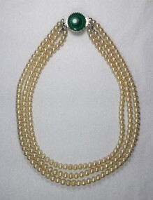 Wodonga & District Historical Society Inc
Decorative object - Necklace from the Sarah Coventry jewellery range, Sarah Coventry Jewellery, c. 1970s - 1980s
Sarah Coventry Pty. Ltd. was a North American jewellery company that was established in 1949 by the Stuart family as part of Emmons Jewelry, Inc. It began operations in England and Australia in 1968, and in Australia it moved from Carlton in Melbourne to Wodonga in 1969. The premises were originally on High St. in Wodonga, but a new warehouse was built in Melbourne Rd. later in 1969. It was a direct selling jewellery business using a party-plan model similar to Tupperware and Avon. The sales reps or 'Hostesses' were provided with jewellery samples in demonstration kits, which they displayed at jewellery parties in their homes. The designs for jewellery such as brooches, necklaces, earrings, chokers and bracelets were purchased from freelance designers and jewellery manufacturers rather than in-house designers. In 1979 Sarah Coventry Pty. Ltd. in Wodonga was bought by three Australian businessmen, including Wodonga local Jim Sawyer, and continued to sell jewellery under the name "Sargem Pty. Ltd”, for several more years in the 1980s. As part of the Sarah Coventry collection, the necklace has local significance with the decentralised commercial development of regional centres such as Wodonga in NE Victoria, as well as national and international significance from the perspective of social and economic developments for women after World War II. The direct selling party-plan business model Sarah Coventry was based on is also considered the first of its kind for jewellery.Necklace with three strands of faux pearls and a large faux green stone at the silver toned metal clasp on the front, and a large faux pearl at the clasp on the back. sarah coventry, jewellery, wodonga, costume jewellery, vintage fashion jewellery, necklace, necklaces -
 Wodonga & District Historical Society Inc
Decorative object - Sarah Coventry jewellery pin for 15 years service, c. 1970s - 1980s
Sarah Coventry Pty. Ltd. was a North American jewellery company that was established in 1949 by the Stuart family as part of Emmons Jewelry, Inc. It began operations in England and Australia in 1968, and in Australia it moved from Carlton in Melbourne to Wodonga in 1969. The premises were originally on High St. in Wodonga, but a new warehouse was built in Melbourne Rd. later in 1969. It was a direct selling jewellery business using a party-plan model similar to Tupperware and Avon. The sales reps or 'Hostesses' were provided with jewellery samples in demonstration kits, which they displayed at jewellery parties in their homes. The designs for jewellery such as brooches, necklaces, earrings, chokers and bracelets were purchased from freelance designers and jewellery manufacturers rather than in-house designers. In 1979 Sarah Coventry Pty. Ltd. in Wodonga was bought by three Australian businessmen, including Wodonga local Jim Sawyer, and continued to sell jewellery under the name "Sargem Pty. Ltd”, for several more years in the 1980s. As part of the Sarah Coventry collection, the pin has local significance with the decentralised commercial development of regional centres such as Wodonga in NE Victoria, as well as national and international significance from the perspective of social and economic developments for women after World War II. The direct selling party-plan business model Sarah Coventry was based on is also considered the first of its kind for jewellery.Small rectangular gold metal pin with a small pearl inlay on the proper left side for 15 years service. The 10 K stamp on the back surface suggests it is 10 karat gold.The abraded areas on the clasp on the back expose underlying silver coloured metal indicating that the clasp is plated. "Sarah / SC / 15 / YRS / Coventry" on the front surface. "cTo ® / .... 10K" stamped in the back surface on the lower proper left side indicating 10 karat gold. The (®) symbol indicates that the manufacturer's mark is federally registered with the US Patent and Trademark Office. The 'cTo' is the trademark by O. C. Tanner Jewelry Co. in Salt Lake City, U.S.sarah coventry, jewellery, wodonga, costume jewellery, vintage fashion jewellery, pin, jewellery pins -
 Wodonga & District Historical Society Inc
Decorative object - Sarah Coventry jewellery pin for 5 years service, c. 1970s - 1980s
Sarah Coventry Pty. Ltd. was a North American jewellery company that was established in 1949 by the Stuart family as part of Emmons Jewelry, Inc. It began operations in England and Australia in 1968, and in Australia it moved from Carlton in Melbourne to Wodonga in 1969. The premises were originally on High St. in Wodonga, but a new warehouse was built in Melbourne Rd. later in 1969. It was a direct selling jewellery business using a party-plan model similar to Tupperware and Avon. The sales reps or 'Hostesses' were provided with jewellery samples in demonstration kits, which they displayed at jewellery parties in their homes. The designs for jewellery such as brooches, necklaces, earrings, chokers and bracelets were purchased from freelance designers and jewellery manufacturers rather than in-house designers. In 1979 Sarah Coventry Pty. Ltd. in Wodonga was bought by three Australian businessmen, including Wodonga local Jim Sawyer, and continued to sell jewellery under the name "Sargem Pty. Ltd”, for several more years in the 1980s. As part of the Sarah Coventry collection, the pin has local significance with the decentralised commercial development of regional centres such as Wodonga in NE Victoria, as well as national and international significance from the perspective of social and economic developments for women after World War II. The direct selling party-plan business model Sarah Coventry was based on is also considered the first of its kind for jewellery.Small rectangular gold metal pin for five years service with a faceted pink stone inlay on the proper left side, the name and initials of Sarah Coventry in the central area and three flowers on the proper right side. The 10 K stamp on the back surface suggests it is made of 10 karat gold. Abraded areas on the high points of the clasp on the back surface expose underlying silver coloured metal indicating that the clasp is plated."Sarah / SC / 5 YRS / Coventry" on the front surface. "® cTo / 10 K" stamped into the back surface on the lower proper left side, indicating 10 karat gold. The (®) symbol indicates that the manufacturer's mark is federally registered with the US Patent and Trademark Office. The 'cTo' is the trademark by O. C. Tanner Jewelry Co. in Salt Lake City, U.S.sarah coventry, jewellery, wodonga, costume jewellery, vintage fashion jewellery, pin, jewellery pins -
 Wodonga & District Historical Society Inc
Decorative object - Sarah Coventry jewellery pin for 10 years service, c. 1970s - 1980s
Sarah Coventry Pty. Ltd. was a North American jewellery company that was established in 1949 by the Stuart family as part of Emmons Jewelry, Inc. It began operations in England and Australia in 1968, and in Australia it moved from Carlton in Melbourne to Wodonga in 1969. The premises were originally on High St. in Wodonga, but a new warehouse was built in Melbourne Rd. later in 1969. It was a direct selling jewellery business using a party-plan model similar to Tupperware and Avon. The sales reps or 'Hostesses' were provided with jewellery samples in demonstration kits, which they displayed at jewellery parties in their homes. The designs for jewellery such as brooches, necklaces, earrings, chokers and bracelets were purchased from freelance designers and jewellery manufacturers rather than in-house designers. In 1979 Sarah Coventry Pty. Ltd. in Wodonga was bought by three Australian businessmen, including Wodonga local Jim Sawyer, and continued to sell jewellery under the name "Sargem Pty. Ltd”, for several more years in the 1980s. As part of the Sarah Coventry collection, the pin has local significance with the decentralised commercial development of regional centres such as Wodonga in NE Victoria, as well as national and international significance from the perspective of social and economic developments for women after World War II. The direct selling party-plan business model Sarah Coventry was based on is also considered the first of its kind for jewellery.Small rectangular gold metal pin with a faceted pink stone inlay on the proper left side and a faceted clear stone on the proper right side. Two raised flower motifs on the proper right side. The 10k stamped on the back surface suggests it is made of 10 karat gold.The abraded areas on the clasp on the back expose underlying silver coloured metal indicating that the clasp is plated."Sarah / SC / 10 YRS / Coventry" raised inscription on the front surface. "® cTo / 10 K" stamped on the lower proper left side of the back surface, indicating 10 karat gold. The ® symbol indicates that the manufacturer's mark is federally registered with the US Patent and Trademark Office. The 'cTo' is the trademark by O. C. Tanner Jewelry Co. in Salt Lake City, U.S.sarah coventry, jewellery, wodonga, costume jewellery, vintage fashion jewellery, pin, jewellery pin -
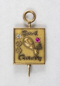
 Wodonga & District Historical Society Inc
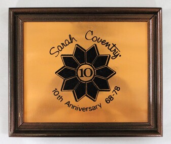
Memorabilia - Framed Sarah Coventry 10th Anniversary plaque for 1968-1978
Sarah Coventry Pty. Ltd. was a North American jewellery company that was established in 1949 by the Stuart family as part of Emmons Jewelry, Inc. It began operations in England and Australia in 1968, and in Australia it moved from Carlton in Melbourne to Wodonga in 1969. The premises were originally on High St. in Wodonga, but a new warehouse was built in Melbourne Rd. later in 1969. It was a direct selling jewellery business using a party-plan model similar to Tupperware and Avon. The sales reps or 'Hostesses' were provided with jewellery samples in demonstration kits, which they displayed at jewellery parties in their homes. The designs for jewellery such as brooches, necklaces, earrings, chokers and bracelets were purchased from freelance designers and jewellery manufacturers rather than in-house designers. In 1979 Sarah Coventry Pty. Ltd. in Wodonga was bought by three Australian businessmen, including Wodonga local Jim Sawyer, and continued to sell jewellery under the name "Sargem Pty. Ltd”, for several more years in the 1980s. As part of the Sarah Coventry collection, the plaque has local significance with the decentralised commercial development of regional centres such as Wodonga in NE Victoria, as well as national and international significance from the perspective of social and economic developments for women after World War II. The direct selling party-plan business model Sarah Coventry was based on is also considered the first of its kind for jewellery.Copper metal plaque commemorating 10 years of the Sarah Coventry Pty. Ltd. jewellery company from 1968 to 1978, in a brown wooden fame. The inscription is in black and flock printed on the copper plaque with '10' in the central of a flower motif."Sarah Coventry. / 10 / 10th Anniversary 68-78"sarah coventry, jewellery, wodonga, costume jewellery, vintage fashion jewellery, copper plaque, commemorative plaque -
 Wodonga & District Historical Society Inc
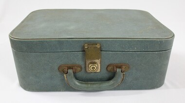
Functional object - Suitcase for a Sarah Coventry jewellery demonstration kit, c. 1970s - 1980s
Sarah Coventry Pty. Ltd. was a North American jewellery company that was established in 1949 by the Stuart family as part of Emmons Jewelry, Inc. It began operations in England and Australia in 1968, and in Australia it moved from Carlton in Melbourne to Wodonga in 1969. The premises were originally on High St. in Wodonga, but a new warehouse was built in Melbourne Rd. later in 1969. It was a direct selling jewellery business using a party-plan model similar to Tupperware and Avon. The sales reps or 'Hostesses' were provided with jewellery samples in demonstration kits, which they displayed at jewellery parties in their homes. The designs for jewellery such as brooches, necklaces, earrings, chokers and bracelets were purchased from freelance designers and jewellery manufacturers rather than in-house designers. In 1979 Sarah Coventry Pty. Ltd. in Wodonga was bought by three Australian businessmen, including Wodonga local Jim Sawyer, and continued to sell jewellery under the name "Sargem Pty. Ltd”, for several more years in the 1980s. As part of the Sarah Coventry collection, the suitcase has local significance with the decentralised commercial development of regional centres such as Wodonga in NE Victoria, as well as national and international significance from the perspective of social and economic developments for women after World War II. The direct selling party-plan business model Sarah Coventry was based on is also considered the first of its kind for jewellery.Green vinyl suitcase with the name 'Sarah Coventry' in lower case gold letters on one corner of the top surface and the number '1348' printed in gold on the back surface. Plated iron alloy hardware securing the handle on the front and the locking mechanism."Sarah Coventry" printed in gold letters on one corner of the top surface of the suitcase. "1348" printed in gold on the back surface, which could be the number of the demonstration kit.sarah coventry, jewellery, wodonga, costume jewellery, vintage fashion jewellery, demonstration kit suitcase, suitcase, suitcases -
 Wodonga & District Historical Society Inc
Decorative object - Gold toned chain from the Sarah Coventry jewellery range, c. 1970s - 1980s
Sarah Coventry Pty. Ltd. was a North American jewellery company that was established in 1949 by the Stuart family as part of Emmons Jewelry, Inc. It began operations in England and Australia in 1968, and in Australia it moved from Carlton in Melbourne to Wodonga in 1969. The premises were originally on High St. in Wodonga, but a new warehouse was built in Melbourne Rd. later in 1969. It was a direct selling jewellery business using a party-plan model similar to Tupperware and Avon. The sales reps or 'Hostesses' were provided with jewellery samples in demonstration kits, which they displayed at jewellery parties in their homes. The designs for jewellery such as brooches, necklaces, earrings, chokers and bracelets were purchased from freelance designers and jewellery manufacturers rather than in-house designers. In 1979 Sarah Coventry Pty. Ltd. in Wodonga was bought by three Australian businessmen, including Wodonga local Jim Sawyer, and continued to sell jewellery under the name "Sargem Pty. Ltd”, for several more years in the 1980s. As part of the Sarah Coventry collection, the gold toned chain has local significance with the decentralised commercial development of regional centres such as Wodonga in NE Victoria, as well as national and international significance from the perspective of social and economic developments for women after World War II. The direct selling party-plan business model Sarah Coventry was based on is also considered the first of its kind for jewellery.Gold toned metal chain with a rhombus-shaped attachment next to the clasp, with the Sarah Coventry mark stamped on it."SARAH / COV" which is thought to be first used in 1953.sarah coventry, jewellery, wodonga, costume jewellery, vintage fashion jewellery, gold chains -
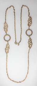 Wodonga & District Historical Society Inc
Decorative object - Gold toned chain from the Sarah Coventry jewellery range, c. 1970s -1980s
Sarah Coventry Pty. Ltd. was a North American jewellery company that was established in 1949 by the Stuart family as part of Emmons Jewelry, Inc. It began operations in England and Australia in 1968, and in Australia it moved from Carlton in Melbourne to Wodonga in 1969. The premises were originally on High St. in Wodonga, but a new warehouse was built in Melbourne Rd. later in 1969. It was a direct selling jewellery business using a party-plan model similar to Tupperware and Avon. The sales reps or 'Hostesses' were provided with jewellery samples in demonstration kits, which they displayed at jewellery parties in their homes. The designs for jewellery such as brooches, necklaces, earrings, chokers and bracelets were purchased from freelance designers and jewellery manufacturers rather than in-house designers. In 1979 Sarah Coventry Pty. Ltd. in Wodonga was bought by three Australian businessmen, including Wodonga local Jim Sawyer, and continued to sell jewellery under the name "Sargem Pty. Ltd”, for several more years in the 1980s. As part of the Sarah Coventry collection, the gold toned chain has local significance with the decentralised commercial development of regional centres such as Wodonga in NE Victoria, as well as national and international significance from the perspective of social and economic developments for women after World War II. The direct selling party-plan business model Sarah Coventry was based on is also considered the first of its kind for jewellery.Gold toned metal chain from the Sarah Coventry jewellery range with two circular elements and two swirling decorative elements, and a small rhombus-shaped attachment near the clasp with the Sarah Coventry mark stamped on it.. "SARAH COV / MADE IN / CANADA" - The 'SARAH COV' mark is thought to be first used in 1953.sarah coventry, jewellery, wodonga, costume jewellery, vintage fashion jewellery, gold chains -
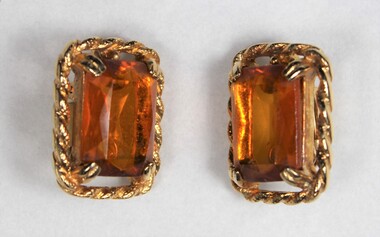 Wodonga & District Historical Society Inc
Decorative object - Gold toned clip-on earrings from the Sarah Coventry jewellery range, c. 1970s -1980s
Sarah Coventry Pty. Ltd. was a North American jewellery company that was established in 1949 by the Stuart family as part of Emmons Jewelry, Inc. It began operations in England and Australia in 1968, and in Australia it moved from Carlton in Melbourne to Wodonga in 1969. The premises were originally on High St. in Wodonga, but a new warehouse was built in Melbourne Rd. later in 1969. It was a direct selling jewellery business using a party-plan model similar to Tupperware and Avon. The sales reps or 'Hostesses' were provided with jewellery samples in demonstration kits, which they displayed at jewellery parties in their homes. The designs for jewellery such as brooches, necklaces, earrings, chokers and bracelets were purchased from freelance designers and jewellery manufacturers rather than in-house designers. In 1979 Sarah Coventry Pty. Ltd. in Wodonga was bought by three Australian businessmen, including Wodonga local Jim Sawyer, and continued to sell jewellery under the name "Sargem Pty. Ltd”, for several more years in the 1980s. As part of the Sarah Coventry collection, the earrings have local significance with the decentralised commercial development of regional centres such as Wodonga in NE Victoria, as well as national and international significance from the perspective of social and economic developments for women after World War II. The direct selling party-plan business model Sarah Coventry was based on is also considered the first of its kind for jewellery.Pair of gold toned metal clip-on earrings with rectangular brown glass settings. "MADE IN U.S.A." - on a label attached to the back of one of the earrings.sarah coventry, jewellery, wodonga, costume jewellery, vintage fashion jewellery, earrings