Showing 25582 items matching "plenty-township-estate"
-
 Greensborough Historical Society
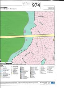
Map, Pioneer children's graves precinct, 1848-1860
Map showing the location and surrounds of Pioneer Children's Cemetery on the Plenty River in Greensborough. Children from pioneer families are buried here.Official government planning map for the Pioneer Children's Graves Precinct.Printed coloured copy of map of Plenty River areapioneer childrens cemetery, greensborough, partington, whatmough -
 Greensborough Historical Society
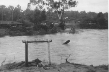
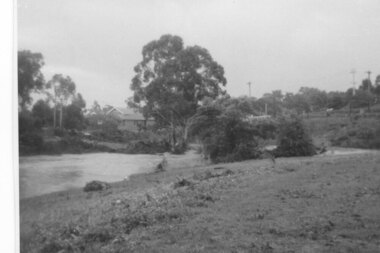
Photograph - Digital image, Plenty River in flood 1972 at Rand Street crossing (3), 1972_
Plenty River in flood Greensborough 1972. There were two major floods in Greensborough at the time, 1972 and 1974. Poulter Reserve was created after the 1972 flood and had to be re-established following the 1974 flood.Digital copy of black and white photograph.plenty river, floods -
![Photograph - Digital image, Old Plenty River Swimming Pool [Greensborough], 02/05/2013](/media/collectors/4f729f5697f83e03086015b8/items/5729bfe02162f108e8de938c/item-media/5729c0092162f108e8de9a06/item-fit-380x285.jpg) Greensborough Historical Society
Greensborough Historical SocietyPhotograph - Digital image, Old Plenty River Swimming Pool [Greensborough], 02/05/2013
These photographs of the old swimming pool in the Plenty River were taken in 2013 to show changes over 40 years, based on Ron Reynold’s sketches in the 1973 publication “Greensborough and Greenhills” published by Cypress Books. Digital copy of 3 colour photographs.greensborough and greenhills, plenty river swimming pool, ron reynolds -
 Greensborough Historical Society
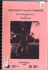
Book, Victoria Archaeological Survey, The Plenty Valley Corridor: the archaeological survey of Aboriginal sites / by Isabel Ellender 1989, 1989_
This archaeological survey of th Plenty Valley was conducted by Isabel Ellender in 1989 for the Ministry of Planning and Environment. The area studied is north of Greensborough to Whittlesea. A number of Aboriginal sites were identified and recommendations made for the future.103 p., illus., maps. Plastic spiral binding.plenty river, aboriginal heritage sites -
 City of Moorabbin Historical Society (Operating the Box Cottage Museum)
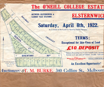
Flyer, 1922
At the end of World War One, there was a renewed interest in residential land and a number of estates opened up in the Municipality of Moorabbin.Example of the progress of the Municipality of MoorabbinAdvertising flyer for auction of real estate sales - plan of building blocks for saleThe O'Neill College Estate, Elsternwick - Auction Saturday 8 April 1922denver street, brentani avenue, railway cresent (now riddell parade), elsternwick, real estate, auction -
 Whitehorse Historical Society Inc.
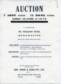
Document, Mt Vista Estate, 1950 ?
Brochure advertising auction on 13 October 195? of 'Mt Vista Estate'Brochure advertising auction on 13 October 195? of 'Mt Vista Estate' comprising 7 shop sites and 12 home sites at Mount Pleasant Road, Nunawading. Agent: Wm White & Sons Pty Ltd.Brochure advertising auction on 13 October 195? of 'Mt Vista Estate' mount vista estate, lorikeet street, nunawading, mount pleasant road, eugenia street, land sales -
 Whitehorse Historical Society Inc.
Document, Aspinall's Estate, Box Hill, 1937
List of allotments to be sold by the City of Box Hill for municipal charges in Mont Albert, Box Hill, Surrey Hills and Burwood in 1937. Also 8 small farm blocks in Aspinall's Estate (Old Abattoirs Paddock).land sales, mont albert, box hill, surrey hills, burwood, aspinalls estate, aspinall road, box hill north, woodhouse grove, abattoirs paddock, edward haughton pty ltd -
Whitehorse Historical Society Inc.
Document, McGlone's Estate Mitcham, 1/04/1921 12:00:00 AM
Copy of pamphlet of McGlone's Estate, Mitcham auctioned April 1921.Copy of pamphlet of McGlone's Estate, Mitcham auctioned April 1921. 24 allotments. Bordered by Whitehorse Road, McGlone Street, Station Street and Mitcham railway line and station. Original in Haughton maps, LaTrobe Library.Copy of pamphlet of McGlone's Estate, Mitcham auctioned April 1921. land sales, auctions, mcglone, john, mcglone, elizabeth, whitehorse road, mitcham, mcglone street, mitcham, station street, mitcham, mitcham railway station, haughton map collection, state library of victoria. latrobe library -
![Photograph - Digital image, 122 Main Road Lower Plenty [Caroline Barnett and son Alfred], 1945c](/media/collectors/4f729f5697f83e03086015b8/items/54bec7c92162f1159cba0945/item-media/54bec7f82162f1159cba0dcb/item-fit-380x285.jpg) Greensborough Historical Society
Greensborough Historical SocietyPhotograph - Digital image, 122 Main Road Lower Plenty [Caroline Barnett and son Alfred], 1945c
122 Main Road Lower Plenty; looking toward the Primary School with Caroline Barnett and son Alfred. Photographs from the collection of Peter Blackbourn, a descendant of the Chapman Stock family. Annotations to photos by Peter Blackbourn.Digital copy of black and white photograph.peter blackbourn, 122 main road lower plenty, caroline barnett -
 Greensborough Historical Society
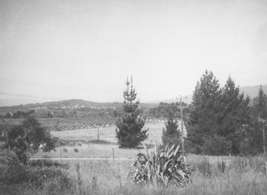
Photograph - Digital Image, Aftermath of Plenty River flood 1972 in Poulter Reserve. (4), 1972_
Plenty River in flood around the Poulter Reserve. There were two major floods in Greensborough at the time, 1972 and 1974. Poulter Reserve was created after the 1972 flood and had to be re-established following the 1974 flood.Digital copy of black and white photograph.plenty river, floods -
 Greensborough Historical Society
Photograph - Digital Image, Plenty River in flood 1972, view at the Rand Street Crossing, 1972_
Plenty River in flood at the Rand Street Crossing. There were two major floods in Greensborough at the time, 1972 and 1974. Poulter Reserve was created after the 1972 flood and had to be re-established following the 1974 flood.Digital copy of black and white photograph.plenty river, floods -
 Greensborough Historical Society
Newspaper Clipping, Diamond Valley Leader, Plenty of talent in the pool, 19/04/2017
A Yarra Plenty Swimming Club star has won the club's first ever gold medal after a good showing at the Tasmanian State Age, Open and Under 11 Swimming Championships held last month.News article 1 page, black text, colour image.yarra plenty swimming club -
 Kew Historical Society Inc
Plan - Subdivision Plan, Golf View Estate, c.1922
Pru Sanderson, in her groundbreaking ‘City of Kew Urban Conservation Study : Volume 2 - Development History’ (1988), summarised the periods of urban development and subdivisions of land in Kew. The periods that she identified included 1845-1880, 1880-1893, 1893-1921, 1921-1933, 1933-1943, and Post-War Development. These periods were selected as they represented periods of rapid growth or decline in urban development. An obvious starting point for Sanderson’s groupings involved population growth and the associated economic cycles. These cycles also highlighted urban expansion onto land that was predominantly rural, although in other cases it represented the decline and breakup of large estates. A number of the plans in the Kew Historical Society’s collection can also be found in other collections, such as those of the State Library of Victoria and the Boroondara Library Service. A number are however unique to the collection.The Kew Historical Society collection includes almost 100 subdivision plans pertaining to suburbs of the City of Melbourne. Most of these are of Kew, Kew East or Studley Park, although a smaller number are plans of Camberwell, Deepdene, Balwyn and Hawthorn. It is believed that the majority of the plans were gifted to the Society by persons connected with the real estate firm - J. R. Mathers and McMillan, 136 Cotham Road, Kew. The Plans in the collection are rarely in pristine form, being working plans on which the agent would write notes and record lots sold and the prices of these. The subdivision plans are historically significant examples of the growth of urban Melbourne from the beginning of the 20th Century up until the 1980s. A number of the plans are double-sided and often include a photograph on the reverse. A number of the latter are by noted photographers such as J.E. Barnes.The subdivision advertised as the Golf View Estate in Camberwell included 32 allotments bordering on Glen Iris Road, Smith Street (now Smith Road), St Andries Street and Camberwell Road. In the post-war period in which the subdivision took place, the significance of Camberwell as the ‘Heathiest of Suburbs’ because of the undulating nature of its terrain and its high altitude was promoted. The sales pitch aimed at attracting and selling to ‘Gentlemen’ who could take advantage of the nearby trams, which would take them to the ‘heart of the city’.subdivision plans - camberwell, golf view estate -
 Kew Historical Society Inc
Plan - Subdivision Plan, St Helliers Estate, Kew, circa 1910, c.1910
Pru Sanderson, in her groundbreaking ‘City of Kew Urban Conservation Study : Volume 2 - Development History’ (1988), summarised the periods of urban development and subdivisions of land in Kew. The periods that she identified included 1845-1880, 1880-1893, 1893-1921, 1921-1933, 1933-1943, and Post-War Development. These periods were selected as they represented periods of rapid growth or decline in urban development. An obvious starting point for Sanderson’s groupings involved population growth and the associated economic cycles. These cycles also highlighted urban expansion onto land that was predominantly rural, although in other cases it represented the decline and breakup of large estates. A number of the plans in the Kew Historical Society’s collection can also be found in other collections, such as those of the State Library of Victoria and the Boroondara Library Service. A number are however unique to the collection.Subdivision plans are historically important documents used as evidence of the growth of suburbs in Australia. They frequently provide information about when the land was sold on which a built structure was subsequently constructed as well as evidence relating to surveyors and real estate and financial agents. The numerous subdivision plans in the Kew Historical Society's collection represent working documents, ranging from the initial sketches made in planning a subdivision to printed plans on which auctioneers or agents listed the prices for which individual lots were sold. In a number of cases, the reverse of a subdivision plan in the collection includes a photograph of a house that was also for sale by the agent. These photographs provide significant heritage information relating house design and decoration, fencing and household gardens.In the subdivision of part of Crown Portion 82, bordered by John and Sackville Streets and Cotham and Burke Roads, over 100 lots were offered for sale. In addition to the designated lots, a number of key locations are also identified. These include the Genazzano Convent to the north of Cotham Road, the Reservoir, St Hilary’s and the land holding of Colonel Parnell on the corner of John Street and Cotham Road. On the Plan, No. 5064, is the handwritten name ‘St. Hellier’s Estate’. St. Helliers, the home of the Dumaresq family is shown beside St. Hilary’s.subdivision plans - kew, st helliers estate -
 Ringwood and District Historical Society
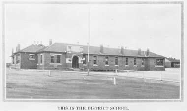
Photograph, Ringwood State School photograph for land sale - Charm-View Estate, Heathmont - 1926
Printed below picture, "This is the district school". Written on back of photograph, "Photo taken from Sub. Div. Plan Land Sale Charm-View Estate, Heathmont. 1926?" -
 Ringwood and District Historical Society
Photograph, Panfield Estate 1960 (off Mullum Rd.) previously Vic. Hunter's Orchard
Typed below photograph, "Panfield Estate 1960 (off Mullum Rd.) previously Vic. Hunter's Orchard. 1960". "Panfield Ave. off Mullum Rd. to Wonga Rd." -
 Eltham District Historical Society Inc
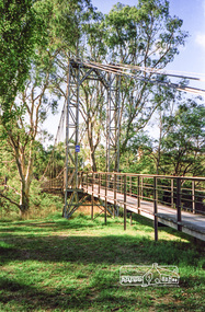
Photograph, Pedestrian suspension bridge over the Yarra River at Lower Plenty, 18 Apr 1998, 1998
Lower Plenty Heritage Excursion included the former monastery of the Blessed Sacrament Fathers, now Odyssey House, and its suspension footbridge across the Yarra River. Odyssey House drug rehabilitation centre in Bonds Road, Lower Plenty is a distinctive landmark, especially when viewed from across the Yarra at Templestowe. It was built in the 1950’s as a seminary for the Blessed Sacrament Fathers. Because of the poor and circuitous road access, a suspension footbridge was built across the river. As well as providing easy access for the priests residents of Templestowe could attend services at the seminary. The bridge is now part of the Yarra Trails system.Roll of 35mm colour negative film, 6 strips Also photographic prints 10 x 15 cmKodak Gold 200-6activities, blessed sacrament fathers, bonds road, bridge, foot bridge, lower plenty, odyssey house, seminary, yarra river -
 Eltham District Historical Society Inc
Photograph, Pedestrian suspension bridge over the Yarra River at Lower Plenty, 18 Apr 1998, 1998
Lower Plenty Heritage Excursion included the former monastery of the Blessed Sacrament Fathers, now Odyssey House, and its suspension footbridge across the Yarra River. Odyssey House drug rehabilitation centre in Bonds Road, Lower Plenty is a distinctive landmark, especially when viewed from across the Yarra at Templestowe. It was built in the 1950’s as a seminary for the Blessed Sacrament Fathers. Because of the poor and circuitous road access, a suspension footbridge was built across the river. As well as providing easy access for the priests residents of Templestowe could attend services at the seminary. The bridge is now part of the Yarra Trails system.Roll of 35mm colour negative film, 6 strips Also photographic prints 10 x 15 cmKodak Gold 200-6activities, blessed sacrament fathers, bonds road, bridge, foot bridge, lower plenty, odyssey house, seminary, yarra river -
 Greensborough Historical Society
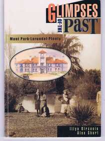
Book, Glimpses of the past: Mont Park, Larundel, Plenty. By Iliya Bircanin and Alex Short, 1909o
The psychiatric hospitals at Mont Park, Larundel and Plenty closed in the late 1970s and this book gives a brief history of the group of hospitals. The area has since been redeveloped into a residential area, although some of the original buildings remain.This book gives an outline of life within the hospital precinct.64 pages, illus. (some col.). Cover includes sepia photo 'Pond at Farm Worker's Block circa 1927'.mont park hospital, larundel hospital, plenty hospital, iliya bircanin, alex short, nemps, north eastern metropolitan psychiatric services -
 Eltham District Historical Society Inc
Folder, Shire of Eltham Pioneers Photograph Collection; Application by Yarra Plenty Regional Library for a Local History Grant to digitise collection, 1982-2014
Material pertaining to the production of a history of the Shire of Eltham, "Pioneers & Painters: One Hundred Years of Eltham and its Shire" in recognition of the shire's centenary in 1971 Item Title Caption 04771-1 Shire of Eltham Pioneers Photograph Collection: Application; Local History Grants Program 2012-2013, Yarra Plenty Regional Library, 7 November 2012 04771-2 Shire of Eltham Pioneers Photograph Collection: Local History Grants Program 2012-2013, Yarra Plenty Regional Library, 31 May 2013 04771-3 Notification to Eltham District Histoprical Society of successful application for Local History Grants Program by Yarra Plenty Regional Library, 5 June 2013 04771-4f 04771-5 Media Release, Craig Ondarchie MP announcing a grant of $3,775 for the Shire of Eltham Pioneers Photograph Collection, 3 July 2013 Grant for digitising selected images within the collection 04771-6 Details of negative and prints scanned as part of Local History Grants Project, 23 October 2013 04771-7 Feedback from Eltham Disitrict Historical Society to Local and Family History Librarian, Yarra Plenty Regional Library in support of Local History Grant application to digitise the Shire of Eltham Pioneers Photograph collection, 27 October 2012. The idea to develop a book on the history of the Shire of Eltham to be edited by noted author, Alan Marshall in celebration of the shire's centenary was initiated in 1969. The Shire of Eltham Historical Society undertook significant research in conjunction with Alan Marshall locating material at various institutions and other societies; interviewing longer term residents and a public campaign through the local press to acquire photographic material for duplication and use in the book. The public campaign received generous response and the material collected became the genesis for the Shire of Eltham Pioneers Photograph collection now held in partnership between Eltham District Historical Society and Yarra Plenty Regional Library (Eltham Library). This material covers the application to digitise the bulk of the collection with the assistance of a Local History Grants project made available through Public Records Office Victoria; the result of which was successful and has enable d Eltham District Historical Society and Yarra Plenty Regional Library to embrace a much wider audience from far afield in sharing the local history of the Eltham Shire and Eltham districtPaper documents A4 size; one item laminatedeltham district historical society, local history grants program 2012-2013, public record office victoria (prov), yarra plenty regional library, shire of eltham pioneers photograph collection -
 Eltham District Historical Society Inc
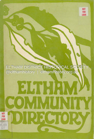
Book, Cressy Street Playgroup, Eltham Community Directory, 1981
Community directory developed by the Cressy Street Playgroup in partnership with the Eltham and Lower Plenty Playgroup Parents' Association with the aim to gather and share information about the area and its resources to relieve the pressure on parents of young families. The Directory covers the Shire of Eltham and surrounds and includes sections: Emergency, Your Shire, Family and Personal Services, Health, Sports and Recreation, Leisure and Learning, Community Services Groups, Churches, Pets and Vets and Eltham Habitat. Many names and locations are referenced throughout the Directory. The information in this Directory is significant because it provides a snapshot of community and related services for the residents of the Shire of Eltham in the early 1980s.72 pagesnon-fictionCommunity directory developed by the Cressy Street Playgroup in partnership with the Eltham and Lower Plenty Playgroup Parents' Association with the aim to gather and share information about the area and its resources to relieve the pressure on parents of young families. The Directory covers the Shire of Eltham and surrounds and includes sections: Emergency, Your Shire, Family and Personal Services, Health, Sports and Recreation, Leisure and Learning, Community Services Groups, Churches, Pets and Vets and Eltham Habitat. Many names and locations are referenced throughout the Directory. The information in this Directory is significant because it provides a snapshot of community and related services for the residents of the Shire of Eltham in the early 1980s.community, shire of eltham, directory, 1981 -
 Greensborough Historical Society
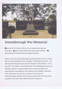
Article - Article and Photograph, Yarra Plenty Regional Library, The Fallen Soldiers' Memorial: Greensborough War Memorial Park, 20/01/2013
Article regarding World War 1 Fallen Soldiers Memorial, Greensborough War Memorial Park. Article downloaded from Wikinorthia.Article and photograph greensborough war memorial park, fallen soldiers memorial greensborough -
 Greensborough Historical Society
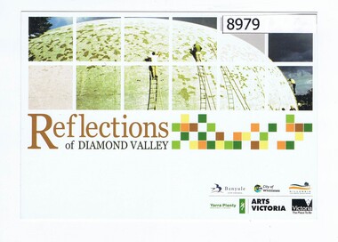
Postcard, Reflections of Diamond Valley, 1979
This postcard depicts the Diamond Creek Community Centre (Bini Shell) during its construction in 1979. It is part of the YPRL image collection. Colour postcardyarra plenty regional library, arts victoria, diamond creek, bini shell diamond creek -
 Greensborough Historical Society
Card - Membership card, Yarra Plenty Regional Library, Library Card, 2012c
Barcoded membership card issued to S. Ballantyne 2012, cancelledPlastic card printed in orange and green on white, verso black on white yarra plenty regional library, membership cards -
 Greensborough Historical Society
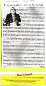
Article - Newspaper Clipping (copy), Watsonia Traders Association, Expansion of a vision: Watsonia Library, 05/07/2003
A short history of Watsonia Library from its beginnings in 1987 to the renovation and extension undertaken in2001-2002. Branch manager Lynne Fox in interviewed.News article in black and whiteyarra plenty regional library, yprl, watsonia library, lynne fox -
 Greensborough Historical Society
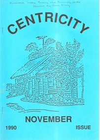
Magazine, Plenty Valley Graphics and Desktop Puiblishing, Centricity November 1990, 1990_11
A collection of short stories, poetry and other writing by students (local women) at the Diamond Valley Living and Learning Centre Greensborough.A publication of writing by local women.40 pages, black and white illus. Blue cover with line drawing of DVLC.On front cover in pen: "Diamond Valley Living and Learning Centre. Donated by Rosie Bray"diamond valley living and learning centre, dvlc, diamond valley learning centre, writing, centricity -
 Greensborough Historical Society
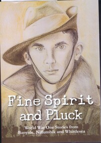
Book, Yarra Plenty Regional Library, Fine spirit and pluck: World War I stories from Banyule, Nillumbik and Whittlesea, 2016_
A collection of stories of World War One from Banyule, Nillumbik and Whittlesea.Collected by Yarra Plenty Regional Library with contributors from the local area.227 p., illus. 2 copiesyarra plenty regional library, world war 1 -
 Greensborough Historical Society
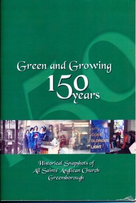
Book, Green and growing: 150 years. Historical snapshots of All Saints' Anglican Church Greensborough, 2005_07
This small book tells the story of All Saints' Anglican Church Greensborough, celebrating its 150th Anniversary in 2005.56 p., black & white and col. illus. 2 copies.all saints' anglican church -
 Greensborough Historical Society
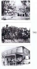
Postcards, Yarra Plenty Regional Library, Eltham District Historical Society postcards, 1900s
1. Watson's Hotel, cnr. Pitt Street and Main Road Eltham c. 1902. 2. Main Road Hurstbridge. 3. Railway workers celebrate the first steam train to Hurstbridge 1912Three black & white postcardswatson's hotel, eltham, hurstbridge, hurstbridge train line, eltham district historical society -
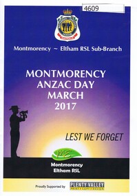 Greensborough Historical Society
Booklet, Montmorency-Eltham RSL Sub-branch, Montmorency and Eltham Anzac Day Dawn Service and March 2017, 25/04/2017
Anzac Day Services conducted by the Montmorency-Eltham RSL Sub-Branch included a Dawn Service in Eltham and a March in Montmorency. Both are included in this booklet.16 p. booklet, black & white print and photographs, col. cover; separate sections for both Montmorency and Eltham services, reversed orientation.anzac day, montmorency-eltham rsl