Showing 17953 items matching "shows"
-
 Ballarat Tramway Museum
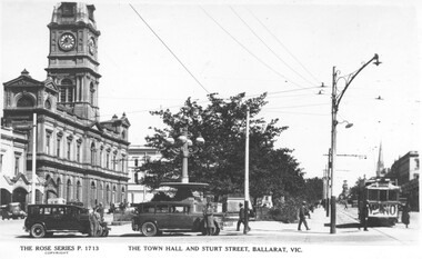
Negative - Copy, Rose Stereograph Co, "The Town Hall and Sturt Street Ballarat Vic", - rear
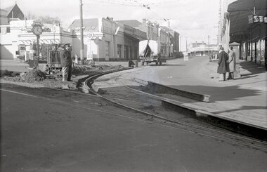
Yields information about Ballarat 's trams in the 1930's and three street scene at the City Centre with the Town Hall in the background. Shows nature of the area with street lights and parked motor vehicles and a sign on the tram regarding prohibition and a vote on the banning of the sale of alcohol.Copy negative of a black and white photograph from Ray Pearson Collection, taken by Dave Macartney in 1975c of the intersection of Sturt and Lydiard St during the late 1920s. From the Rose series P1713, photograph of a postcard. Shows tram with a "Vote No" banner - about a local vote on prohibition in Ballarat? See Reg Item 5117 for another version and 8979 for the actual postcard. Image from the Ray Pearson album used to replace previous image 30/5/2020. Ray Pearson identified this as No. 6 in his album.trams, tramways, sturt st, prohibition, town hall -
 Ballarat Tramway Museum
Photograph - Black & White Photograph/s, John Webster, 21/08/1955 12:00:00 AM
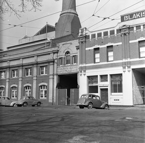
Yields information about the appearance of the Geelong Powerhouse and Depot mid 1950's prior to closure.Black and white photograph of the Geelong Tramways Powerhouse and depot with the depot gates partially closed. Shows motor vehicles parked outside and the name above door "The Melbourne Electric Supply Company Limited" Photographed by John Webster, 21/8/1955. Two copies of the print held. See Reg Item 4233 for the inside view. Two copies. Actual print is a large part of the negative held. On Negative in ink "EH29" Negative scanned at hi res 4/6/2020 and image updated.On rear in ink in top right hand corner "EH 29 / 21-8-55"tramways, trams, geelong, depot, mesco -
 Ballarat Tramway Museum
Photograph - Black & White Photograph/s, 1954
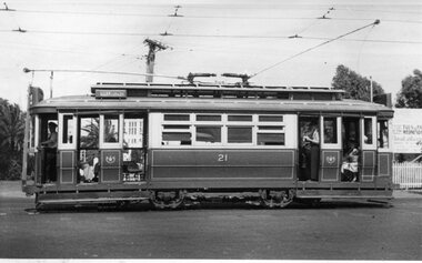
Yields information about the appearance of Geelong 21 and the crews operating it on a hot summers day.Black and white photograph of Geelong No. 21, side on view, inbound to the city area with the destination of Belmont. Shows the crews in shirt sleeves, the blinds drawn and the length of the tram with its two trolley poles. Photo by an unknown photographer, 1954. Dave O'Neil confirmed June 30/2009, the tram is travelling from North to Belmont, lost likely at Mercer and Railway Terrace. Entrance to the goods yard is at the rear of the tram, and Gordon institute can been seen through the front entrance. See Related documents.In pencil on the rear 1954.tramways, trams, geelong, crews, railway station, tram 21 -
 Ballarat Tramway Museum
Photograph - B&W print of donated negative, John Webster, 21/08/1955 12:00:00 AM
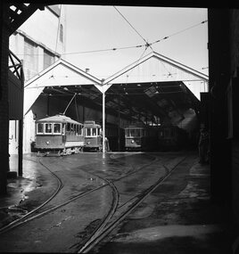
Yields information about the appearance of the Geelong Powerhouse and Depot mid 1950's prior to closureBlack and white digital print from scan of a donated negative showing the inside view of the depot looking inwards from the exit with the Scrubber tram or Track Cleaner, Trams 21 and 40 and one other on the depot fan. Shows the trackwork fan and the overhead details. Assumed photo taken on the same day as the others - 21-8-1955. Black and White prints made from scan of negative. Original Negative stored with Negatives. Negative scanned at hi res 4/6/2020 and image updated.On left hand side of the negatives in ink is "EI 5"tramways, trams, geelong, depot, tram scrubber, tram 21, tram 40 -
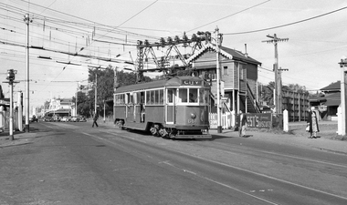
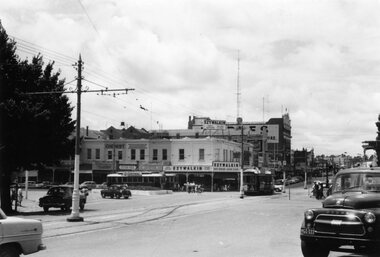 Ballarat Tramway Museum
Photograph - Black & White Photograph/s, Ron Hann, Jan. 1963
Yields information about the Charing Cross Bendigo tram terminal, and nature of the traffic arrangements.Black and white print on heavy matt photographic paper of a view of Bendigo Charing Cross tram terminal area from western side. Has two single truckers in Pall Mall and a bogie tram. Shows the tram crossover in High St and a number of motor vehicles. Has the Ezywalkin building on the north east corner. 2nd copy - laser print - with date etc on rear - added 22/2/2010, copy from Ron Hann. Printed on Fujifilm, Fujicolour Crystal Archive for Frontier"On rear in pencil "Charing Cross 1963" 2nd copy has label "Reference 6/214/25" Photo by Ron Hann" and another label "Charing Cross Bendigo 01.63"tramways, trams, bendigo, charing cross -
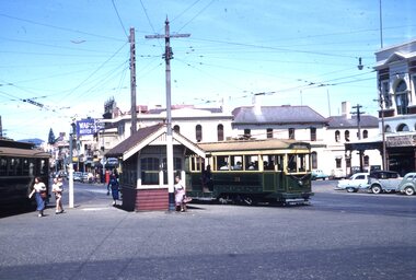 Ballarat Tramway Museum
Slide - 35mm slide/s, Ben Parle, Jan. 1954
Kodachrome Transparency - 35mm slide - cardboard mount, with one side with red border and words "Kodachrome Transparency" top and bottom. On the other side is "Made in England" and "View from this side". Photo taken by Ben Parle 1/1954. Photo of Ballarat No. 39, and possibly No. 21 at the intersection of Sturt St and Grenville St., showing the tramway stop shelter at this location. Has the Bucks Head Hotel and the Maypole Delicatessen in the background and shows a number of passengers on the inbound tram and at the tram stop. For high resolution scan see btm2816h.tif "Sturt St Ballarat" "1/54"tramways, trams, bridge st, sturt st, grenville st, bucks head hotel, tram 39, tram 21 -
 Ballarat Tramway Museum
Slide - 35mm slide/s, Harry Jackson, Dec. 1971
White cardboard mount, 35mm slide, from the Association of Railway Enthusiast's film strip titled "Provincial Tramway Film Strip" of a Bendigo No. 3 standing at the Eaglehawk terminus with the Town Hall in the background. Tram reflected in shop windows and shows some of the verandas of High St. Eaglehawk. The film strip notes (Reg. Item 2560), provided the following caption details: "Bogie car No. 3 stands at "EAGLEHAWK" in the hot midday sun. = Dec. '71 (Harry Jackson) See image btm2597p.tif for high level scan of image. Stamped on base of slide "11807" and written in ink on top edge "No. 3 Eaglehawk"tramways, trams, are, film strip, high st, eaglehawk, tram 3 -
 Ballarat Tramway Museum
Photograph - Black and White photograph/s - mounted, Hornly's Ballarat, 24/01/1926 12:00:00 AM
Block mounted photograph of the ESCo Employees Tramway Picnic 24.1.1926. Photograph is of the workers and families standing in front of seven buses or trucks, possibly at Moorabool Reservoir. On the left hand side is a truck with a ladder on the side, sign written to show it belongs to the Electric Supply Co. of Victoria. The black and white photograph has been mounted on to a heavy cardboard grey coloured with dark grey bands around the photograph and the edge of the mounting. The bottom right hand corner has been indented with the studio's name "Hornly's Studio Ballarat".trams, tramways, esco, hornly's, picnics, employees -
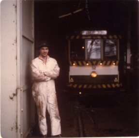 Ballarat Tramway Museum
Photograph - Colour Print, Lilian Butler, Sep. 1971
Possibly has a strong association with Mr Wayne Kell, a SEC Ballarat depot worker.Colour print of a worker (Mr Wayne Kell?) standing by one of the depot doors with tram 32 in the background. The photo of Mr. Kell in Reg Item 1861, shows him with long hair - likely to be the same person - see also 6450 where he has a large cap on. See also Reg Item 6544i2 for a colour slide of this photograph. Item was placed in an envelope marked "Mr Wayne Kell" - retained with photograph in storage folder. Photo printed on Kodak Paper. Photograph by Lilian Butler?in ink on rear "Tram Depot - Wendouree Parade, Ballarat Vic, September 1971, with my compliments Lilian Butlertrams, tramways, sec, depot, personnel, tram 32 -
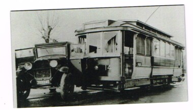 Ballarat Tramway Museum
Domestic Object - Fridge Magnet, Ballarat Tramway Museum (BTM), 2015
Fridge magnet with a photograph of a collision, accident, between SEC Ballarat No. 14 and a motor truck at the intersection of Drummond St. North and Webster St. May or June 1939. Official SEC photo, there are other photos of this collision in the collection. See Reg Items 580, 1019, 1365 and 1366 and 3904 for larger prints of these photographs of these photographs and further details. See also Reg Item 6211 for a fridge magnet version. The tramcar body card shows it was repaired following an accident June 1939. (Note added 2-2-19). trams, tramways, ballarat, drummond st nth, accidents, fridge magnet -
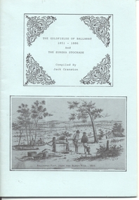 Ballarat Tramway Museum
Book, Jack Cranston, "The Goldfields of Ballarat 1851 - 1886 and The Eureka Stockade", 1970's?
Book - "The Goldfields of Ballarat 1851 - 1886 and The Eureka Stockade", compiled by Jack Cranston. Comprises blue cover with 28 pages folded and stapled inside and fold out map glued to the inside of the rear cover, "Map of Ballaarat and Sebastopol" showing the various leads and gold bearing reefs of the goldfields. Also shows the location of Eureka Stockade and Sovereign Hill. Published for the Sovereign Hill Association, 1970's? Looks at the Goldfields, sources of Nuggets, mining population and statistics, the Miners Rebellion and the Stockade. Has numerous illustrations and copies of posters.trams, tramways, gold, eureka, sovereign hill -
 Ballarat Tramway Museum
Photograph - Digital image, 9/04/1958 12:00:00 AM
Yields information about one of the tramcars in the Museum's collection and its operation. Also yields information about a Melbourne level crossing that has been replaced.Digital image of W3 661 as Elsternwick level crossing in Glen Huntly Road, 9/4/1958, taken by Ian Brady. Shows the overhead arrangements, level crossing gates posts, signal box and the disc signal for the catch points. Has an Advertisements for Best Biscuits in the photograph. Glenhuntly road. See emails in the worksheet files - see re use and acknowledgement conditions. See Reg item 4162 for a John Alfred photograph after level crossing replacement works commenced featuring 661.trams, tramways, level crossings, tram 661 -
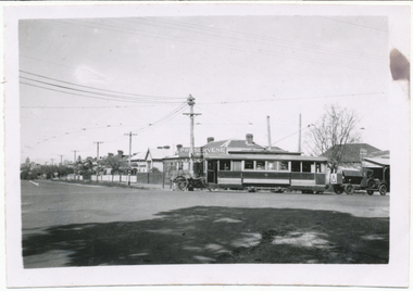 Ballarat Tramway Museum
Photograph - Digital image, 15/10/1940 12:00:00 AM
Yields information about the Macarthur and Drummond Sts intersection during 1940 and the trams in used and the welding truck.Digital image from the Wal Jack Ballarat Album of a photograph of No. 12 turning from Macarthur St into Drummond St north. Has a shop advertising Preservene Soap in the background and the old welding truck with a warning sign on the back at the rear of the tram. Shows the houses in Drummond St North prior the trees growing. Photo taken 15-10-1940. See image i2 for rear of photograph. See image i3 for hi res scan of print. See image i4 for hi res scan of negativeOn rear of photograph in ink "Ballarat No. 12 turning out of Macarthur St in Drummond St 15-10-40. Note old "Beam" welding unit.trams, tramways, macarthur st, drummond st nth, welding, tram 12 -
 Ballarat Tramway Museum
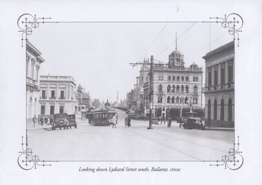
Photograph - Black & White Photograph/s, c1927
Yields information about Sturt and the streetscape with a horse tram outside St Andrews Kirk with two small boys playing.Black and white historic photograph downloaded from a picture resource website within a decorative frame. Printed with an inkjet printer. Titled "Looking down Lydiard Street south, Ballarat. circa:" shows an ESCo tram turning from Lydiard St north into Sturt St with many parked motor vehicles and pedestrians. Has the Post Office, Craigs Hotel, Commonwealth Bank, National Mutual Building and the Bank of Australasia in the photograph. One centre pole in the photograph. Photo c1927 Original photo from a postcard?trams, tramways, lydiard st north, poles, post office, esco, tram 20 -
 Bendigo Historical Society Inc.
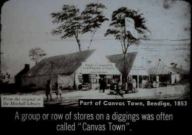
Slide - DIGGERS & MINING. STORES AT THE DIGGINGS, c1853
Diggers & Mining. Stores at the diggings. From the original in the Dixon Gallery, Public Library of NSW. Part of canvas town, Bendigo, 1853. A group or row of stores on the diggings was often called ''Canvas Town''. Slide shows Beauchamp's Australian Stores, Gold bought with a small hut at the rear with a chimney. Second tent - Beauchamp's Australian Store. 3rd tent unnamed. There are goods for sale outside the first tent appear to be cradles for mining. 2 children to the left of picture. Markings: 13 994.LIF. 5. Used as a teaching aid.hanimounteducation, tertiary, goldfields -
 Bendigo Historical Society Inc.
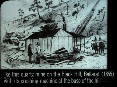
Slide - DIGGERS & MINING. DIGGERS AND MINERS, c1855
Diggers & Mining. Diggers and miners. Like this quartz mine on the Black Hill, Ballarat (1855) with its crushing machine at the base of the hill - - - Slide: Shows dwellings one made from timber with chimney, one made from canvas, with a veranda and what appears to be a round metal chimney. 2 men in the for ground have some timber and could be contemplating a timber dwelling. There are a couple of other dwellings in the background. Not many trees left on the hill. Markings: 26 994:LIF I. Used as a teaching aid.hanimounteducation, tertiary, goldfields -
 Bendigo Historical Society Inc.
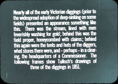
Slide - DIGGERS & MINING: THE DIGGINGS - THE DIGGERS
Diggers & Mining: The Diggings - The Diggers. Slide reads: Nearly all of the early Victorians diggings (prior) to the widespread adoption of deep skinking on some fields) presented an appearance something like this. There was the stream, lined with men feverishly washing for gold; behind this was the field proper, honeycombed with claims; behind this again were the tents and huts of the diggers, what stores there were, and - perhaps - in a clearing, the headquarters of a Commissioner. The following frames show Tulloch's drawings of three of the diggings in 1851. Markings: 2 994.LIF 6. Used as a teaching aid.hanimounteducation, tertiary, mining -
 Ballarat Tramway Museum
Negative, Wal Jack, early 1950's
Yields information about the reconstruction of the curve on the Mt Pleasant line at Stones Corner.Negative and Digital images of the Wal Jack Ballarat Negative file of the relay of the outer rail at Stones Corner on the Mt Pleasant line. Shows removed rails and methodology of the work. Photo taken at 1220 as shown on the clock - all workers at lunch. In the view are the Listers COR service station, the Inspector chatting with a person, the Ballarat East Post Office and the Stones retail store. The first welding truck (cloth covered roof) with a wandering lead device. See Reg Item 7740 for a photo of similar work at Main and Barkly St.trams, tramways, stones corner, trackwork, track repairs, main road, victoria st, mt pleasant, inspectors, welding -
 Ballarat Tramway Museum
Functional object - Destination Roll, NSW Department of Road Transport and tramways, "Newcastle"
Destination roll use din a Newcastle tram - on linen, black background with various colours and white letters. Each destination 10" high. 6 joins in roll, each approx. 800 to 900 long section. Letters in caps. Destinations shown are: West Wal'send Wallsend and Platsburg New Lambton Lambton Broadmeadow Adamstown Waratah Merewether B'H (Beach) Newcastle Tighe's Hill Mayfield Glebe Boreas Road Special Depot Sport Grd Show Grd Racecourse Speedway Telford St Hamilton Depottram, trams, newcastle, destination roll -
 Kew Historical Society Inc
Photograph - Peel Street Health Centre : Official Opening, 1930
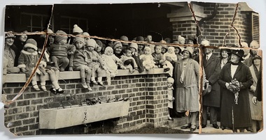
The North Kew Centre was the third established at North Kew. It followed a lease of a house at 50 Willsmere Road. The Peel Street building was designed by Mr Chipperfield. Messrs McIntosh and Taylor were the successful tenderers, the price being 1,240 pounds. The North Kew Baby Health Centre was finally opened on 18 June 1930 in the presence of the mayor, councillors and citizens of Kew, and representatives of the Infant Welfare Council. A report in The Age of 19 June described the opening in detail as well as the features of the new Centre. These included: "The rooms ... filled with flowers, pink and mauve hydrangeas and native heath, and the walls are adorned, with a charming frieze, representing windmills, flocks and a fairy tale goose girl. On the walls are hygiene editions of the funniest of Belloc's "Cautionary Tales" revised as posters, Outside there is promise of a gay garden, and a lovely view of green fields sloping to a shining bend of the river." Early photographic record of the opening of an early baby health centre in Kew.[Badly damaged] black and white photograph of the opening of the North Kew Baby Health Centre in Peel Street. The photo is mounted on card, and shows mothers and their children on the veranda, and officials at right. The latter includes the Mayoress and probably Vera Scantlebury. All mothers wear hats as do most of the children. [When the photograph was presented to the Society in 1979, it was described in the first Acquisitions Register as framed. Some time after that it was removed from its frame and badly broken. A separate photocopy of the original photograph is also held in the collection.]Earliest inscription: "Peel Street Health Centre / Official Opening 1930 / donated by Sr Costello and Sr Bewish [sic] 1979 / Copy purchased by ..... for Centre". Old Accession number in Texta: "KH-133 Kew Historical Society". Separate later label: "Opening North Kew Baby Health centre 1930". north kew baby health centre, peel street (kew), baby health centres - kew (vic) -
Kew Historical Society Inc
Plan - Willsmere Park Estate, Kew, 1926
Subdivision plans and real estate flyers/brochures reveal a number of aspects of urban development and history. The Kew Historical Society's collection of these plans, as well as advertisements extracted from magazines, cover key aspects of community development and architectural history of Kew and Kew Eat as well as surrounding suburbs. While most of the plans in the collection were gifted to the Society by the former City of Kew, a number of other plans and advertisements have been donated by individuals, of which this is an example.Original 4-page, bifold subdivision plan of the Willsmere Park Estate, Kew. The 1926 land sale advertised '40 superb villa allotments' on the 'Yarra Heights'. Streets within the subdivision included: Willow Grove, Kilby Road, Elm Grove and Belford Road. The double page spread on pages 2 and 3 shows the detailed plan of the 40 lots, surrounded by public parkland [Willsmere Park] and the Kew Golf Links. By the time that this version of the plan was released, only the lots on Willow Grove and Kilby Road remained. willsmere park estate -- kew (vic.), subdivisions - kew (vic.), subdivisions -- kew east (vic.), willsmere park -- kew east (vic.) -
 Kew Historical Society Inc
Photograph - Victorian Canoe Club, Dight's Falls, Studley Park, 1920-30
Canoeing on the River Yarra at Melbourne was an important and widespread recreational pursuit for Melbournians, especially in the first half of the twentieth century. The Victorian Canoe Club was formed in 1912 at a meeting in Melbourne and its first committee elected in the same year. Records indicate that the Club continued into at least the 1950s .The album has historic and social significance as a record of recreational activities (as well as canoe making) in the early years of the twentieth century. It has local significance as the site of the headquarters of the Club was in Studley Park. A number of photographs in the album provide vistas of Kew on the Yarra that are otherwise unavailable.One of 24 labelled photos in part album, originating from the Victorian Canoe Club, which had its headquarters in Studley Park, Kew. The album includes a photographic record of canoe construction and also locations in Studley Park and Kew where the canoes were used. The subject of this photograph is identified as 'Dight's Falls, Studley Park'.The view shows an early trestle bridge across the Falls on which people, possibly members of the Club, are standing. The point of view would appear to be looking up river towards Fairfield."Dyghts Falls, Studley Park"victorian canoe club, river yarra, burke road -- kew (vic.), dight's falls -- fairfield (vic.), dight's falls -- kew (vic.), dight's falls -- yarra river -
 Kew Historical Society Inc
Map, MMBW, MMBW Plan No.39 Kew & Heidelberg, 1900-1910
The Melbourne and Metropolitan Board of Works (MMBW) was established by an act of the Victorian Parliament in 1890 to prepare for and to implement a sewerage and water reticulation system across what was then inner Melbourne, its surrounding and middle distance suburbs, including Kew. The MMBW was disbanded in 1991.The map collection of the Kew Historical Society has at its core the historic maps assembled and originally stored in the City Engineer's Department of the City of Kew. These include maps in a number of scales. The vast majority of maps were produced by the MMBW in the first two decades of the twentieth century, and are solid working maps, backed by linen for durability. These maps are historically significant to Kew, the City of Boroondara and to the history of the development of state utilities in Victoria. A number of the Kew maps have additional details added by former municipal officers, including the levels reached by various floods. As these were working documents, information was added to them long after the period of their initial production and distribution.Early map of part of the Borough of Kew, created in the first decade of the twentieth century, at a scale 160 ft to 1 inch. The map covers what was then the north western section of Kew, bordered on its north by Wills Street and the Kew Lunatic Asylum, in the west by the River Yarra [and the later added Yarra Boulevard] , by Princess Street in the East and Holroyd Street in the south. The map shows the extent of urban development by that time, prominent institutions and the outlines of built structures in the municipality. Contour lines were added in ink to the map at a later stage.MELBOURNE AND METROPOLITAN BOARD OF WORKS / PLAN NO. 39 / KEW & HEIDELBERGmelbourne & metropolitan board of works, mmbw maps, mmbw plans, borough of kew, cartography -
 Kew Historical Society Inc
Map, MMBW, MMBW Plan No.67 Kew, 1900-1910
The Melbourne and Metropolitan Board of Works (MMBW) was established by an act of the Victorian Parliament in 1890 to prepare for and to implement a sewerage and water reticulation system across what was then inner Melbourne, its surrounding and middle distance suburbs, including Kew. The MMBW was disbanded in 1991.The map collection of the Kew Historical Society has at its core the historic maps assembled and originally stored in the City Engineer's Department of the City of Kew. These include maps in a number of scales. The vast majority of maps were produced by the MMBW in the first two decades of the twentieth century, and are solid working maps, backed by linen for durability. These maps are historically significant to Kew, the City of Boroondara and to the history of the development of state utilities in Victoria. A number of the Kew maps have additional details added by former municipal officers, including the levels reached by various floods. As these were working documents, information was added to them long after the period of their initial production and distribution.Early map of part of the Borough of Kew, created in the first decade of the twentieth century, at a scale 160 ft to 1 inch. The map covers what was then the north central part of Kew, bordered on its north by the Outer Circle Railway Spruzen and Beresford Avenues, in the west by Princess Street, in the south by High Street, and in the east by (about) Belford Road. The map shows the extent of urban development by that time, prominent institutions and the outlines of built structures in the municipality. Contour lines were added in ink to the map at a later stage.MELBOURNE AND METROPOLITAN BOARD OF WORKS / PLAN NO. 67 / KEW melbourne & metropolitan board of works, mmbw maps, mmbw plans, borough of kew, cartography -
 Kew Historical Society Inc
Map, MMBW, MMBW Plan No.68 Kew, 1900-1910
The Melbourne and Metropolitan Board of Works (MMBW) was established by an act of the Victorian Parliament in 1890 to prepare for and to implement a sewerage and water reticulation system across what was then inner Melbourne, its surrounding and middle distance suburbs, including Kew. The MMBW was disbanded in 1991.The map collection of the Kew Historical Society has at its core the historic maps assembled and originally stored in the City Engineer's Department of the City of Kew. These include maps in a number of scales. The vast majority of maps were produced by the MMBW in the first two decades of the twentieth century, and are solid working maps, backed by linen for durability. These maps are historically significant to Kew, the City of Boroondara and to the history of the development of state utilities in Victoria. A number of the Kew maps have additional details added by former municipal officers, including the levels reached by various floods. As these were working documents, information was added to them long after the period of their initial production and distribution.Early map of part of the Borough of Kew, created in the first decade of the twentieth century, at a scale 160 ft to 1 inch. The map covers what was then the north central part of Kew, bordered in the north by Oak Avenue, in the west by the Yarra River and Connor's Creek, in the south by Beresford and Carnegie Avenues, and in the east by Glass's Creek and Burke Road. The map shows the extent of urban development by that time, prominent institutions and the outlines of built structures in the municipality. Contour lines and the levels of historic floods were added in ink to the map at a later stage.MELBOURNE AND METROPOLITAN BOARD OF WORKS / PLAN NO. 68 / KEW melbourne & metropolitan board of works, mmbw maps, mmbw plans, borough of kew, cartography -
 Surrey Hills Historical Society Collection
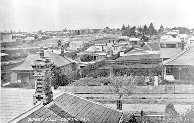
Photograph, Surrey Hills - Looking East from Essex Road, circa 1900, c1900
Date is approximate. Two original post cards of this image - "Surrey Hills - looking East" - were donated by Stephen Wyatt on 10 March 2012. One is blank; the other has been sent to Mrs A Wyatt, C/O Mrs E Young, 'Grand View', Warburton from daughter Nellie from 'The Quantocks', Surrey Hills - postmarked 10 Dec 1906. There is also a reproduction of this image in a framed collage of Surrey Hills photos.This is the earliest known image of the Surrey Gardens. The layout was originally designed by William Guilfoyle, who also designed Melbourne’s Royal Botanic Gardens.Black and white photo taken from an early postcard. Taken from the roof of a house in Essex Road, it shows the development of housing between Essex and Union Roads and includes the section of land fenced off for the Surrey Gardens with paths roughly laid out, one existing tree but no tree planting. The houses depicted are largely Edwardian timber buildings with corrugated rooves. There are still some vacant blocks. Kirkland on Union Road can be seen in the distance, as can some of the shops along Canterbury Road.Lower LHS within original image: " Surrey Hills - Looking East"; on the rear "No 17" in black pen in top LH corner.edwardian style, residential development, kirkland, essex road, suffolk road, norfolk road, surrey gardens, post card -
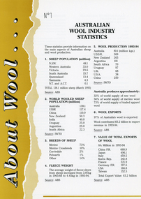 National Wool Museum
Archive - About Wool, International Wool Secretariat, 1995
Part of a collection of books, manuals, photographs, letters and clothing relating to the working life of Stuart Ascough. Stuart's career in the wool industry spanned over 43 years from 1960 to 2003 in various roles including Topmaking Plant Manager at Courtaulds Ltd. in Spennymore, U.K., Operations Manager at Port Phillip Mills in Williamstown Victoria, Marketing Executive, Early Stage Wool Processing at the International Wool Secretariat Melbourne, Australia and General Manager of Victoria Wool Processors Pty. Ltd. in Laverton North, Victoria. Throughout his career Stuart travelled extensively, and in the 1990s worked at many topmaking mills in China on quality improvement projects. He also provided technical advice and training at mills in India, Ukraine, Lithuania, Kyrgyzstan, Russia, Latvia, Byelorussia and other parts of Europe and Asia.A series of ten A4 information leaflets with various titles on the theme of 'About Wool...'. Some leaflets are single sheets double sided, some are folded four sided leaflets. All have different colours and titles, including 'Australian Wool Industry Statistics', 'History of the Australian Wool Industry', 'Guide to Wool Textiles', 'Wool the Fibre', 'Trademarks of Wool', 'Wool and the Environment', 'The Australian Sheep Flock', 'Care of Wool', 'The Natural Properties of Wool' and 'The Processing of Raw Wool into Yarn'. Leaflets show illustrations, logos, images and text.8394.1: No.1 / AUSTRALIAN / WOOL INDUSTRY / STATISTICS 8394.2: No. 2 / HISTORY OF THE / AUSTRALIAN WOOL / INDUSTRY 8394.3: No. 3 / GUIDE TO WOOL TEXTILES 8394.4: No. 4 / WOOL THE FIBRE 8394.5: No. 5 / TRADEMARKS OF WOOL 8394.6: No. 6 / WOOL AND THE ENVIRONMENT 8394.7: No. 7 / THE / AUSTRALIAN SHEEP / FLOCK 8394.8: No. 8: / CARE OF WOOL 8394.9: No. 9 / THE NATURAL / PROPERTIES OF WOOL 8394.10: No. 10 / THE PROCESSING OF / RAW WOOL INTO YARNstuart ascough, international wool secretariat, victoria wool processors, port phillip mills pty ltd, topmaking, career, wool industry, mills, leaflet -
University of Melbourne, Burnley Campus Archives
Plan, School of Primary Agriculture & Horticulture - Burnley, c. 1925-1926
Copy of plan photographed at the Public Records Office Victoria. Central Administration Correspondence Files 1912-1939 ITEM. VPRS 10163/P0003/2. Accomodation Burnley School Part 1. Traced from M.M.B.W. Plan No. 42. Scale 160 ft=1 in. Level Datum L.M.N. Hobson's Bay. Traced by C.E.B.W. 16.02.1926. Additional matter in red and green inserted by F.E.T.C. 09.02.1926. Note by J.J. Rae (Principal). Lists W.C.s (toilets). Shows 1891 Flood Line. Possibly dates from 1925.prov, school of primary agriculture and horticulture, burnely, j.j. rae -
 Glenelg Shire Council Cultural Collection
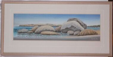
Artwork, other, Ian Rankin, Low Tide - Cape Grant Area, 1990
Depiction of a beach with large boulders in the foreground. The boulders are covered in lichen and algae, and beach sweeps up towards centre right of image. The central third of painting shows the sea (continuing behind the boulders), depicted in blue with white highlights and dark blue shadows. It is edged in the background by a cliff face (painted in brown and grey). Sky is darker blue at top and lighter blue where it meets the horizon. Mounted in double matt (pale tan on faun) with decorative cut-out border, framed under glass in wooden frame.Front: Rankin '90 (lower right) (white paint) Back: 333 (upper left) (sticker) 1990- (upper left) (pencil). Low tide Cape Grant area September 1990 $350 Pastel Ian Rankin. 46 Hurd St Portland Vic 3305 Phone Portland 231465. Phone 055/231465.cape grant, seascape, beach -
 Northern District School of Nursing. Managed by Bendigo Historical Society Inc.
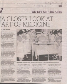
Document - Article in Bendigo Advertiser - original. "A closer look at art of medicine"
The Northern District School of Nursing opened in 1950 in to address the issues around nurse recruitment, training and education that had previously been hospital based. The residential school was to provide theoretical and in-house education and practical training over three years. The students would also receive practical hands-on training in the wards of associated hospitals. The Northern District School of Nursing operated from Lister House, Rowan Street, Bendigo. It was the first independent school of nursing in Victoria and continued until it closed in 1989. The book "The First of its Kind" was published in 2015. Printed in Bendigo by "Bendigo Modern Press". Memories compiled by Peter Rosewall; who attended the last NDSN school PTS 108 between 1986 - 89.Original newspaper article from Bendigo Advertiser 23 January 2014 titled " A closer look at the art of medicine". A photograph in the article shows School 64 1965 with one tutor nurse and six student nurses looking at a dummy patient in a hospital bed. The article was about an exhibition being held at the Post Office Gallery which was entitled " A cure for all ills: medicine in Bendigo" which opened on 7th February. This followed a brief history of medicine in Bendigo from the time of the Gold Rush. The Curator was Clare NeedhamThe newspaper article has the words Bendigo Advertiser written on it. memoir, nursing, ndsn, medicine in bendigo history