Showing 11375 items matching " centre road"
-
 Melbourne Tram Museum
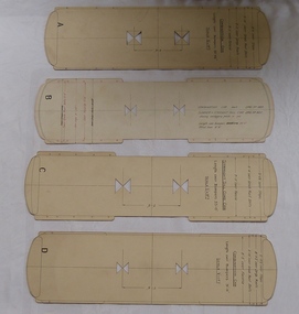
Drawing, Melbourne & Metropolitan Tramways Board (MMTB), "Car Templates", c1920 onwards
Set of 14 tram car templates contained within Reg Item 356, cut from card board to indicate the over all dimensions of the various type of tramcars. Would have been used in the drawing office for checking clearances on buildings, trackwork, junctions. Cut with holes in the centre to enable this to be done. Scale 1/2" = 1 foot. .1 - Marked "A" - for a combination car - 30' 11.25" long, 7'6" wheelbase .2 - "B" - for a combination car - 32' long, 6'6" wheel base to drawing R489 and summer or straight sill car to drawing R820. .3 - "C" - Straight Sill combination car - 33' long, 7'6" wheelbase. .4 - "D" - Combination car, length 31'11", 7'6" wheelbase .5 - "E" - Combination car, length 35', 7' wheelbase .6 - "F" - DC Bogie car, to Drawing 112, length - 44' 3.5", truck centres 22 '4" .7 - "G" - ditto length 44' 5.5", truck centres 23' 7.5" .8 - "H" - ditto length 44' 5.5", truck centres 24' 7.5" .9 - "J" - four motor bogie, to drawing 854, length 45' 6", truck centres 24'6" .10 - "K" - Combination car, length 35', 12' Radiax truck. .11 - Bogie tramcar, W class length 48', truck centres 26' 6" .12 - ditto, W2 534, length 48', truck centres 26' 0" .13 - W4 class tram, .14 - W5 730, length 46' 6', truck centres 28'trams, tramways, mmtb, plans, drawings, templates -
 Melbourne Tram Museum
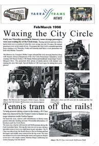
Magazine, Yarra Trams, "Yarra Tram News", 1998
384.1 - Folded A3 sheet - Feb / March 1998 issue of "Yarra Tram News", featuring articles on the City Circle tram service, tram 966 at the Tennis Centre, Customer surveys, trackwork in Victoria Parade, capital works, depots updates and Grand Prix. 384.2 - Folded A3 sheet - Aug/Sept 1988 - City circle tram award, route 70 deviation works, George Litchen, capital works and depots updates. 384.3 - Folded A3 sheet - July 1999 - Edition 17 - time keeping, OH&S, note from CEO John Wilson, website, Mercilita Manigan, depots and Yarra Power - substation DC opening issues. trams, tramways, yarra trams, city circle, tram depot, grand prix, trackwork -
 Lakes Entrance Historical Society
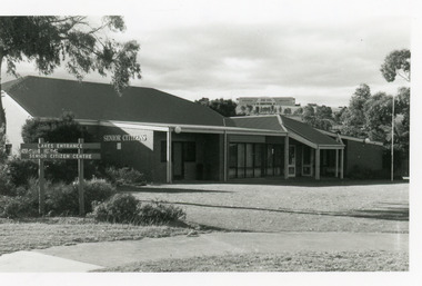
Photograph - Senior Citizen's Centre, 1989
Built on part of former Primary School pine plantation.Colour photograph of Lakes Entrance Seniors Club Rooms at Coates Road, showing a brick building with hip roof. Ramp to side entry, main entry on east side. Tambo Shire Offices on hill in background. Lakes Entrance Victoriacommunity facilities, recreation -
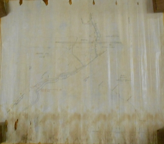
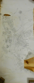
![Map, Millbank Estate Bacchus Marsh Thursday 4th October 1888 [Land sales], 1924](/media/collectors/5e461d8021ea67224c82f2a1/items/67765662eb6d2cbd24e0797f/item-media/67765682eb6d2cbd24e07a41/item-fit-380x285.jpg) Bacchus Marsh & District Historical Society
Bacchus Marsh & District Historical SocietyMap, Millbank Estate Bacchus Marsh Thursday 4th October 1888 [Land sales], 1924
The Millbank Estate was a parcel of land close to the centre of the shopping area of Bacchus Marsh which was sub-divided and offered for sale in 62? lots on the 4th October 1888. The lots had frontages to Ballarat Road (Main Street), Maddingley Road (now Grant Street), Turner Street, Millbank Street, Clarinda Road (now Clarinda Street), and an unnamed street south of Turner Street (possibly known as Grant Street at this time) which connected to Maddingley Road through the vicinity of the present day Bacchus Marsh Hospital. This was a significant sub-division of land and represented a major expansion of residential housing in Bacchus Marsh in the late 19th century. The map includes a wealth of detail about the time of the sale, where it will take place, who the selling agents were, the deposit terms for purchases and details of a special train from Melbourne to Bacchus Marsh on sale day. The location of the allotments in relation to the shopping and commercial area of Bacchus Marsh, Maddingley and the railway station are indicated on an inset map within the overall map and poster. The Millbank Estate area was an area which had once belonged to the Grant family who were prominent early citizens of Bacchus Marsh and lived in a house in this area known as 'Millbank'.This land sale map is a typical example of housing estate land sales advertising maps produced by real estate agents in this era. The map is significant for the detailed information it provides about when and where land was sold for new housing estates in Bacchus Marsh in the late nineteenth century.Single page map showing land allotments for sale at auction in Bacchus Marsh in October 1888. A significant portion of the map is missing from the bottom right side. land sales bacchus marsh, land subdivsion bacchus marsh, housing estates land sales bacchus marsh, grant family bacchus marsh, millbank estate land sales -
 Melbourne Tram Museum
Slide - Set of 6, Warren Doubleday, 9/03/1970 12:00:00 AM
Set of 6 Colour slides- Anscochrome plastic mount taken on 9-3-1970 of the shunting of trams for the Moomba Parade in Sturt St and City Road, prior to the deviation of the tracks to go around the Arts Centre. .1 - W2 631 in turning into City Road from Sturt St .2 - W2 629 turning from St Kilda Road, in to City Road .3 - W2 639 and 550 in Sturt St .4 - W2 550 - route 64, City in Sturt St .5 - W2 629,SW6 898 and 322, Sturt St. .6 - W2 641, 387 and others Sturt St.Has slide number written on itemtrams, tramways, city road, sturt st, moomba, parades, st kilda road, w2 class, tram 611, tram 629, tram 639, tram 550, tram 898, tram 322, tram 641, tram 387 -
 Bendigo Historical Society Inc.
Plan - MARKS COLLECTION: PLAN OF COLIBAN CHANNEL
Plan, hand drawn on waxed paper: Coliban Channel through centre of plan. Written on LH side right of passage over 1 1/2 chains from Melbourne Road Written in red rail water may be returned into channel here VWS fence 3682 drawn in dotted line. Head of drop to bottom of channel drawn inside elevation view on bottom RH corner of plan. Plan also shows Railway reserve, machinery site (un-named)plan, bendigo, coliban channel -
 Merri-bek City Council
Photograph - Digital print on Ilford Fibre Pearl paper, Kim Kruger, Within ten miles of Melbourne 1, 2022
merri-bek public art collection -
 Ringwood and District Historical Society
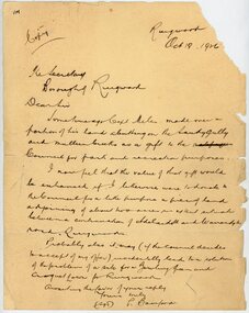
Letter, From Philip Bamford to Borough of Ringwood gifting a parcel of land for park and recreation purposes
1929 saw the establishment of the Ringwood Bowls Club initially located on the land now occupied by the Eastland Shopping Centre. It moved to its current location in Loughnan Road, Ringwood in 1997.Hand-written letter from Philip Bamford to To Borough of Ringwood's Town Clerk giving a parcel of land for park and recreation purposes. Probable site for bowling green and croquet lawn. The land would adjoin similar donation from Capt Miles [Miles Park]. Dated 18th October 1926.city of ringwood bowls club, ringwood bowling club, ringwood bowls club, lawn bowls, bowling -
 Flagstaff Hill Maritime Museum and Village
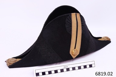
Uniform - Bicorn Hat and Hat Box, late 19th - early 20th century
This hat and hat box was donated to Flagstaff Hill Maritime Village by the family of Doctor William Roy Angus, Surgeon and Oculist. It is part of the “W.R. Angus Collection” which includes historical medical equipment, surgical instruments and material once belonging to Dr Edward Ryan and Dr Thomas Francis Ryan, (both of Nhill, Victoria) as well as Dr Angus’ belongings. The Collection’s history spans the medical practices of the two Doctors Ryan, from 1885-1926 plus that of Dr Angus, up until 1969. McDade is the surname of Dr Angus’ daughter Berry (Berenice) McDade nee Angus. This had belonged to her father Dr William Roy Angus, Surgeon and Oculist (1901 –1970), who wore it on the ship T.S.S. LARGS BAY when travelling from Australia to Scotland for extended studies to be a “Fellow” of the Royal College of Surgeons in Edinburgh in 1929. This bicorn, cocked hat was worn with narrow points towards the front and back. It is decorated with flat gold braid or ‘lace’ with a geometrical design. Regimental lace was worn on the uniform and headdress of regimental officers in the 19th century. Gold lace chevrons were worn on coats to signify rank. Drummers and Foot Guards also wore regimental lace to distinguish them from other military personnel. In the late 19th century the English and Welsh infantry officers’ uniforms displayed a rose-pattern lace. The gold bullion and underlying crimson ‘eyes’ have been used to signify the rank of the owner. Crimson eyes were used for military personnel, and blue eyes were used for naval personnel. Different numbers and colours of the bullion and eyes may have been used to represent different military ranks. The Regulations specify nine tassels and eleven underlying eyes but there could have been variations. We have not yet identified the rank for this particular hat but hats such as this were part of the Australian and British naval uniforms in the early 20th century. The gold button’s emblem features a cross with five stars, a crown, and the motto “AUT PACE AUT BELLO,” which translates as “either in peace or in war.” Museum Victoria has a similar button and writes that buttons with this design were used by the Victorian Volunteers in the nineteenth century. The Australian War Memorial Curator of Military Heraldry advised Museum Victoria that these buttons dated from 1880 to 1892 and were worn by regular, unranked soldiers. Tasmanian Midshipman Alan Casey, who served the British and Australian Navy from 1919 to 1933 and retired as a Lieutenant Commander, owned a similar officer's bicorn hat. His hat and epaulettes are in the Tasmanian Maritime Museum's collection. The Australian War Memorial has a hat that is very similar in design, described as an “Artillery Staff Officer’s cocked had with plume, worn by Volunteer Artillery Staff in the Victorian Colonial Military Forces”. That hat is different in that it has a plume and the braid and button are silver. Berry MdDade, the donor, has used the hat many times as a dress-up hat but doesn’t know the origin of it. The hat seems to fit the design of the Staff Officers in Victorian Volunteers in Colonial times, but the button on this hat was used for unranked volunteers. Also, military uniforms usually have very clear manufacturer’s labels, as they are made by reputable companies under contract to the Defence Department. The manufacturer’s mark is not discernible on this hat. The origin, original wearer and use of this particular hat is unclear. The military bicorn cockade hat belonged to Dr William Roy Angus and is part of the W.R. Angus Collection. It is significant for still being located at the site connected to Doctor Angus being the last Port Medical Officer in Warrnambool. The collection of medical instruments and other equipment is culturally significant, as an historical example of medicine from late 19th to mid-20th century. Dr Angus assisted Dr Tom Ryan, a pioneer in the use of X-rays and in ocular surgery. Black bicorn cocked hat and case. It appears to be part of a 19th-century Colonial full-dress naval officer's uniform. The long, narrow crescent-shaped hat is made of beaver fabric and the crown is lined with crimson silk and finished with a hand-stitched leather sweatband. On one flat side is a pleated black silk, lace cockade woven in the pattern of oak leaves and acorns. The cockade is overlaid with a double row of gold lace braiding secure with a Victorian Volunteer’s gold button. Wide diagonal bands of black lace braid trim are on each side of the gold braiding. The other side of the hat is plain. The front and back points of the hat each have seven gold bullion tassels with nine underlying twists of crimson ‘eyes’. The fitted metal carry case has a catch and a plaque on one side. The button bears a crown and cross with five stars and a motto. Inside the hat is a white name tag with clear adhesive over it, with black printed text with the name “Mc Dade”. The hat is part of the W.R. Angus Collection.The hat has no maker’s marks although there is a darker colour in the centre where there could have been a label. Inside the hat is taped a printed label; “Mc DADE 801 1032” Button’s emblem- a cross with five stars, under a crown, all within a buckled belt with the motto “AUT PACE AUT BELLO” [either in peace or in war] The plaque on the case has no legible marks.flagstaff hill, warrnambool, shipwrecked coast, flagstaff hill maritime museum, maritime museum, shipwreck coast, flagstaff hill maritime village, great ocean road, dr w r angus, t.s.s. largs bay, berry mcdade, 19th century colonial military uniform, artillery staff officer’s cocked had, victorian volunteers, victorian colonial military forces, colonial militia, aut pace aut bello, cocked hat, cockade hat, bicorn hat, military bullion, oak leaves and acorns pattern, gold bullion tassels, military heraldry, w.r. angus collection., australian navy, british navy, uniform -
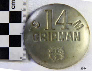 Flagstaff Hill Maritime Museum and Village
Badge - Gripman Badge, Stokes & Sons, Jul 1916 - Nov. 1919
This cable tram Gripman’s badge, or driver’s badge, was part of a tram driver’s uniform. The inscriptions on the front of the badge identify it as belonging to Gripman number 14, at the South Melbourne Car House depot of the Tramways Board. The Gripman Badge would be re-issued whenever another Gripman takes over the position. Cable trams were invented in America in 1873. In Melbourne, cable trams were in use from 1885 until 1940, with a network of up to 1200 cable cars or 'dummies' and trailers travelling at around 9.5 miles (15km) per hour along 46 miles (74km) of double tracks. The Gripman drove the dummy car, operating the heavy levers to connect the gripping gears to the cable installed in a slot in the road. To turn at intersections he would skilfully disconnect, freewheel around the corner and carefully reconnect to the continuously operating steel cable. Large winding gears in an Engine House along the line pulled the cable along, powered by steam engines and later electric engines. The gripping gears were in the centre of the car's floor with seating all around the sides, a dangerous place for curious children. , whose worried parents would guide them into the tram that was towed behind the dummy car. The Melbourne Tramways Board operated the cable trams between July 1916 and November 1919 after taking over from the privately operated Melbourne Tramway and Omnibus Company. In 1919, the Melbourne and Metropolitan Tramways Board (MMTB) took over the Tramways Board. Stokes & Sons: - The maker of the badge, Thomas Stokes, migrated to Melbourne from Birmingham in 1854 and set up business in Mincer Lane as a die-sinker, producing medals, tokens, buttons and silverware, and an engraving service. He moved to Flinders Lane in 1856. After a time, in 1894, the business became Stokes & Sons Pty: Ltd, electroplates and badge makers at Post Office Place in Melbourne. The maker's mark 'Stokes & Sons' was made on badges until 1962. LOCAL CONNECTION: -t was common practice to recycle the used cables from the tramway. For example, the Wollaston Bridge in Warrnambool, Victoria, is suspended by recycled cable tram Melbourne. (Other recycled cables were used for fencing wire.) -Portland's cable tram is an example of the cable trams used in Melbourne from 1885 to 1940.This badge was used to identify a Gripman who operated a cable car tram's dummy car for the Tramways Board in Melbourne between 1916 and 1919. It represents the need for people to be able to identify workers in the service industry, a need still addressed today by staff ID badges and digital identification. The badge also represents the period in Melbourne's history when cable cars were used for public transport for over four decades, gradually changing from steam to electric power. Trams still have an important role in Melbourne's public transport. Badge, round hollow metal dome with two open metal guides on the back. A cable tram Gripman (driver) badge with embossed inscriptions on the front and stamped on the back. There is a logo of entwined letters T and B on the front. It identifies Gripman number 14, South Melbourne, Tramway Board. It was made by Stokes & Sons of Melbourne. Impressed into the front: "S / 14 / M" "GRIPMAN" Logo intertwined "T" and "B" Embossed on reverse "STOKES &o SONS"flagstaff hill, flagstaff hill maritime museum and village, warrnambool, maritime museum, maritime village, great ocean road, shipwreck coast, badge, gripman, stokes & sons, numesmatics, tramway, tram, tram driver, uniform, cable tram, identification, cable car driver, tramway board, south melbourne, melbourne tramways board, tb, mtb, mmtb, melbourne and metropolitan tramways board, tramway button, gripman button, id, identification badg, staff badge, name badge, employee, grip car, dummy car -
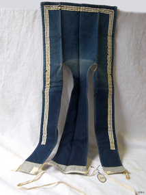 Flagstaff Hill Maritime Museum and Village
Uniform - Sailor's Collar, Early to mid-20th century
This sailor's collar is part of a naval uniform. It once belonged to R S Wallace, who served in the RAN (Royal Australian Navy) and on the HMAS Warrnambool for three years. After the war he made several ship models including the sailing ship Cutty Sark. From January 1857 the Australian Navy uniform was formally established. The uniform, referred to as a 'sailor's suit', includes a blue flap collar such as this one. Sailors in the Royal Australian Navy wore collars of this design from the early 20th century. The rating personnel of the Royal Canadian Navy were issued with a very similar collar from 1910 to the 1950s. The blue denim collars were buttoned or died inside their tops with the back and the striped portion of the front flaps showing.The square sailor's collar represents the uniform of a rating sailor in the Royal Australian Navy in the early to mid-20th century, connecting it to the maritime history of Australia and the evolution of the uniform of the navy. The collar is the only one in this museum's collection and is connected to a sailor who service in the RAN on the HMAS Warrnambool for three years.Sailor's collar. A square collar of blue cotton fabric with three flaps or strips. Three white stripes make a border on the outside edges and two flaps; the centre flap that has no stripes. There is an inscription. The underside is lined with white cotton fabric that has thin blue stripes. Tapes are attached for fastening the collar. The Royal Australian Navy collar once belonged to R S Wallace."R.S. Wallace"flagstaff hill, flagstaff hill maritime museum and village, warrnambool, maritime museum, maritime village, great ocean road, shipwreck coast, sailor’s collar, sailor’s uniform, uniform, military, navy, ran, royal australian navy, r s wallace, seamen's collar, australian defence forces, naval force, sailor's rig, flap collar, naval collar, robert s wallace, collar, sailor's uniform, world war, hmas warrnambool, sailor's suit -
 Bendigo Historical Society Inc.
Document - MARKS COLLECTION: MAP OF EAGLEHAWK/LONG GULLY AREA
Map of Eaglehawk and Long Gully area. Maps shows allotments and areas. Map is split down centre (torn?) and in two pieces. Map was located in Fortuna papers, potentially belonged to G. Lansell. Section of map has been neatly cut out - area near Mt Korong Road and Victoria Hill.map, eaglehawk, long gully, marks collection -
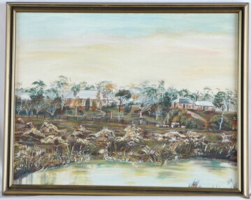 Glenelg Shire Council Cultural Collection
Painting, DEB, Ettrick, n.d
CEMA Art Collection Previously located in History HouseThe painting depicts four buildings within a bush setting. Within the foreground is a body of water with various plants lining it's banks. The midsection of the painting is defined by a wooden fence which extends across the centre of the work. In the background are two sets of two houses. The houses are surrounded by various trees and both sets of houses have roads which extend down to the fenceline. The top half of the work is a yellow and blue sky. The work has a black and gold frame and exposed canvas.Front: DEB Back: (No inscriptions) -
 Ringwood and District Historical Society
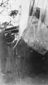
Photograph, Opening Heathmont Railway Station in May 1926, 1926
Opening Heathmont Railway Station in May 1926. The photo shows Herman Pump (centre) and Bill Everard MLA (left), at the gate at the entrance to the railway platform. The Station building was located on the west side of the tracks, near the corner of Heathmont and Canterbury Roads. At the officially opening, the ribbon was cut by Louise Pump, wife of Herman. -
 Bendigo Historical Society Inc.
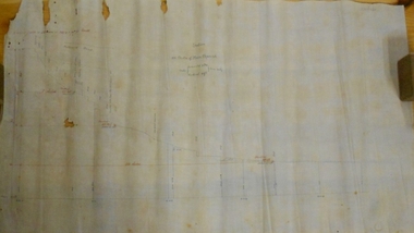
Document - MARKS COLLECTION: SECTION OF MAIN CHANNEL
Plan drawn on waxed type paper, fragile. Written in centre of map 'Section on Centre of Main Channel, Scale horizontal 2 chs, vertical 10ft., to an inch'. Plan shows Melbourne Road on top section. Written in red ink '5,000,000 galls in 24 hours = 3472.2 gals per minute'. Plan located in documents from George Lansell auction.bendigo, mining, water channel section -
 Bendigo Historical Society Inc.
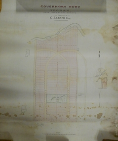
Plan - MARKS COLLECTION: PLAN OF G. LANSELL'S GOVERNOR'S PARK, TOORAK
Plan (tightly rolled) drawn on heavy paper mounted on fabric. On top of plan printed 'Governor's Park Toorak, late Vice-Regal Estate, the property of G. Lansell Esq' On top of plan Yarra River, on bottom Toorak Road, Plan shows subdivision, in centre of which is drawn outline of 8 acres containing the 'Mansion and Grounds'.bendigo, hospital -
 Eltham District Historical Society Inc
Photograph, Old dairy on the Brinkkotter farm, Research, Vic, Jul. 2001
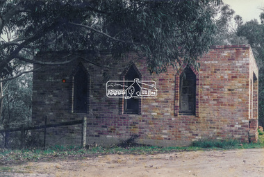
The original St Mary’s Roman Catholic Church (1865-1912) was built of clay brick with buttress walls and a slate roof on the corner of Fordhams Road and Maria Street (Main Road), Eltham South, opposite the present-day Wingrove Park. It was blessed on September 3, 1865. With the arrival of the railway in 1901 and the town centre moving closer to the station, the decision was made to relocate the site of the church to its present-day location on Henry Street at the corner of Main Road. A new timber weatherboard church, also called St Mary's was erected and blessed on October 13, 1912. The church and land cost £1,400 (Evelyn Observer). The original brick church was demolished in the 1920s and the bricks and windows were recycled to build a dairy on the Brinkkotter farm at Research. The timber church was destroyed by fire in 1961 and a new modern architectural (1960s) style church was erected in its place and named Our Lady of Help Christians Church.Colour photographresearch (vic.), brinkkotter, catholic church, eltham, roman catholic church, st marys catholic church -
 Kew Historical Society Inc
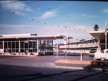
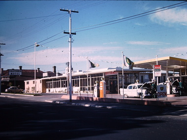
Photograph - California Motel, Barkers Road, Ron Setford, 1961
Ron Setford and his wife Grace Setford lived in Tanner Avenue, East Kew, from c.1946 to c.1995. A keen photographer, he recorded the changing face of Kew over a 20 year period. Apart from 30 photographs of built structures and places in Kew dating from 1960 and 1961, 145 of his 35mm colour slides chronicle the development of the Eastern Freeway through the Yarra Valley over a five year period from c.1972 to c.1977. This important collection was donated to the Society by his granddaughter in 2025.This collection of 175 35mm slides is of local and statewide significance, owing to its subject matter, particularly the major development of road transport infrastructure during the 1970s with the construction of the Eastern Freeway. The photographer also took care to annotate and date most of his slides which enable the researcher to pinpoint temporal and spatial locations.Opened in 1960, the California Motel at 138 Barkers Road, Hawthorn, was located opposite the entrance to Xavier College and built on the site of the former Barker railway station of the closed Kew branch line. The motel was advertised as “away from the hustle and bustle of the city and offering affordable accommodation for the business or leisure traveller”. Special amenities included air-conditioning, a business centre, and swimming pool. The motel had 82 suites. A possibly forgotten, but perhaps essential feature of the motel, was the Caltex Service Station at its entrance. The building was closed in April 2008, extensively vandalised and finally demolished in 2013."California Motel"ron setford, photographs -- kew (vic.) -- 1960s, california motel -- barkers road -- hawthorn (vic.) -
 Kew Historical Society Inc
Photograph - California Motel, Barkers Road, Kew, Ron Setford, 1961
Ron Setford and his wife Grace Setford lived in Tanner Avenue, East Kew, from c.1946 to c.1995. A keen photographer, he recorded the changing face of Kew over a 20 year period. Apart from 30 photographs of built structures and places in Kew dating from 1960 and 1961, 145 of his 35mm colour slides chronicle the development of the Eastern Freeway through the Yarra Valley over a five year period from c.1972 to c.1977. This important collection was donated to the Society by his granddaughter in 2025.This collection of 175 35mm slides is of local and statewide significance, owing to its subject matter, particularly the major development of road transport infrastructure during the 1970s with the construction of the Eastern Freeway. The photographer also took care to annotate and date most of his slides which enable the researcher to pinpoint temporal and spatial locations.Opened in 1960, the California Motel at 138 Barkers Road, Hawthorn, was located opposite the entrance to Xavier College and built on the site of the former Barker railway station of the closed Kew branch line. The motel was advertised as “away from the hustle and bustle of the city and offering affordable accommodation for the business or leisure traveller”. Special amenities included air-conditioning, a business centre, and swimming pool. The motel had 82 suites. A possibly forgotten, but perhaps essential feature of the motel, was the Caltex Service Station at its entrance. The building was closed in April 2008, extensively vandalised and finally demolished in 2013.Nilron setford, photographs -- kew (vic.) -- 1960s, california hotel -- barkers road -- hawthorn (vic.), california motel -- barkers road -
 Stawell Historical Society Inc
Photograph, Whitehall Property Greens Creek
Hutchings family 1. Wimmera River in flood below Whitehall running a banker c. 1920. Ted & Col Hutchings in foreground. 2. Wimmera River in flood looking downstream. No date but possibly same time as no. 1. from same place. 3. Looking over the Wimmera River to Island paddock towards Greens Creek 4. Wimmera River half a banker at Whitehall 5. Wimmera River in flood upstream from carpenter's shop looking towards engine house at Whitehall 5a. Wimmera River in flood. Left to right - blacksmith shop and carpenters' shop. 5b. Taken from the same spot with Emily & Ada Hole, E G (Ted) & Col Hutchings. Blacksmith shop & carpenters' shop, Whitehall. 5c. Wimmera River upstream from the carpenters' shop. Foreground is possibly Belladonna lilies which were all over the river bank in 1992. Whitehall. 5d. Looking downstream towards the loose boxes, Whitehall. 5e. Blacksmiths' shop and carpenters' shop from the pumping station. Wimmera River, Whitehall. 6. Wimmera River in flood at Whitehall. 7. Wimmera River half a banker in front of old hut at Whitehall. 8. Wimmera River Emily Hayes, Edward G (Ted) Hutchings & Colin J Hutchings. 9. Morrl-Morrl - Greens Creek Road opposite back paddock. Whitehall. Black Ford in distance. c. 1919 10. Whitehall woolshed north east aspect, Drive to the right of photo 11. Whitehall woolshed - north east aspect showing the drive to the right 11a. Whitehall woolshed - north aspect 11b. Same tree near woolshed 11c. Same tree again in centre, other trees came up after the 23 flood. Woolshed to the right out of photo. 12. Whitehall woolshed - south aspect, sheep entrance end 13. Whitehall. left to right, Stackyard, stables in the centre and the Wimmera River behind following the trees. 14. Whitehall horse paddock c. 1920. left to right, Machinery shed, stable in the centre. Homestead to the right in distance. There is no windmill. 15. Load of wool from Whitehall woolshed to right. 16. Whitehall c. 1920 before the windmill. left to right, garage and mens' hut. Wimmera river runs along the tree line. 16a. Stables, garage and mens' hut after the construction of the windmill. River behind. 17. Whitehall c. 1922. Note windmill addition. Garage to left, Mens' Hut to right. Jack Donnelly & Edward G (Ted) Hutchings with pet lambs. River behind trees. 18. Whitehall gardens. Summer house to the right, pine tree lined drive in the centre background. Ted & Col Hutchings on the lawn. C. 1920 19. Edward G. (Ted) & Colin J. Hutchings in Whitehall garden. Wimmera River in the background. The building behind the fence is the carpenters' shop which the family lived in while house was rebuilt after fire 15 Jan 1877 20. Whitehall c. 1920. left to right, cattle yard, killing house, Wimmera river behind the fence, and the loose box on the right. Black Orpington chooks in foreground. 21. Bay window (original blinds) in the master bedroom. Whitehall 20 Sep 1992 22. Master bedroom (original wallpaper) Joyce & Col Hutchings, Moyu, Ben & Rebecca Roe 20 Sep 1992 23. Col & Ted's bedroom (original) Marble mantlepiece had been removed. Whitehall. 20 Sep 1992 24. Whitehall kitchen. Large yellow meat oven to left of stove, bread oven far left, extreme right is oven where milk heated to skim cream. Chimney was a central one shared with meat oven. Bread oven chimney separate. 20 Sep 1992 25. Whitehall dairy, made of natural stone with dried brick corners. Entrance behind creeper which is over trellis. 20 Sep 1992. This building still remains in 1 Jun 2023 26. Inside charcoal lined meat cellar. Bottom right is concrete vat for pickling meat in brine. Top of brickwork slightly above ground level. Whitehall 20 Sep 1992 27. Fire foreground was stable flooring which was to left of photo. Machinery shed (thatch roof). 4 posts far left remains of cowshed. Large post in centre foreground is the gate post of corral. River to right. 20 Sep 1992 28. Whitehall machinery shed. Posts on far right are cow shed. Over the river is the island paddock. Wimmera river runs behind machinery shed. 20 Sep 1992 29. Posts of 10 sided corral. Killing house by side of gum tree in centre of photo on far side of corral. To left is one of the bales of the cowshed. Whitehall. 20 Sep 1992 29a. Similar photo in the 1920's. To the right is horsebreaking corral, then cow shed, loose box, haystacks and stable on left. Whitehall. 30. Dining room fire place put in the open fire of the mens' hut, only the chimney remains. To the left is the drive & river. Rebecca Roe, Col Hutchings granddaughter. 20 Sep 1992 30a. Looking down the Whitehall Drive. Mens' Hut (Jack Donnelly in doorway) and garage far left. 1920's 30b. The Drive, Whitehall taken from in front of the mens' hut. Wimmera River on the left. Gum tree on left still there 20 Sep 1992. 30c. Reverse from 30a. Whitehall drive from the front gate looking towards the mens' hut and garage. c. 1926 30d. Curly Donohue leaving for Warracknabeal. Ex mail contractor Omeo to Bright Victoria. C. 1926 30e. Looking down the drive towards front gate. Mens' hut on the right, river on the left. 31. Whitehall from the side. Building in centre behind David is separater room. 2 roomed hut to left of separater room and remains of mens' hut chimney. Photo 16 taken from similar spot. 20 Sep 1992 32. Benjamin Roe (Col Hutchings grandson) in the Carpenters' shop. The family lived in this building after the fire in the 1870's. Whitehall 20 Sep 1992 33. Ford across the Wimmera River at Whitehall (River abt. 5 feet higher than normal) 20 Sep 1992 33a. Wimmera River, Whitehall 34. Site of old bridge before Col Hutchings time. Tree in foreground to right still has bolt from bridge work protuding. A large post was in the centre of photo to make equal distance. 20 Sep 1992 35. Entrance to the old ford. Colin J Hutchings & his daughter, Moyu Roe. Wimmera River, Whitehall 20 Sep 1992 36. Summer house at Whitehall 20 Sep 1992 looking down to the orchard, dark green trees in distance old fruit trees. 36a. Edward & Colin Hutchings in front of the Summer house, Whitehall c. 1921 36b. Summer house looking towards front gate. Whitehall. 36c. Grey thrush in nest box which can be seen in previous photo with summer house in the background. Whitehall. 36d. Summer house from the orchard side. Whitehall. 37a. South side of Whitehall. First window Edith Sutherland's room, 2nd window, Ted & Col's room, bay window master bedroom 38. Taken in middle of front path looking towards front gate. Edith Sutherland in garden. Date palm in centre, cotton palm to left. Whitehall c. 1920's 38a. Garden at Whitehall taken from near the cotton palm. 39. Whitehall 20 Sep 1992 Bay window-master bed, small window to r. of bay-Colin Hutchings born in, front door, window to right-dining room, round the corner- drawing room, window on right, spare bed, verandah on left is spare bed. 39a. Whitehall c. 1920's Date palm on the right. 39b. Win, Colin T & Colin J Hutchings. Date palm in background. Whitehall 1943 39c. Edward George, Colin Thomas, Elizabeth Ambler & Colin James Hutchings wearing RAAF uniform. Date Palm in background. Whitehall c. 1943 39c. Front garden of Whitehall looking from the front right side of the house towards the drive & Wimmera River. Date palm on right, cotton palm on left 20 Sep 1992 40. Taken from bottom left corner of front garden looking towards the summer house. Cotton palm on right. River to the left. 41. Elizabeth A Hutchings beside master bedroom window. Whitehall c. 1920 42. Whitehall (photo of a painting by Wallace) owned by Colin T Hutchings 1982. 42a. Whitehall painting by Wallace after restoration now owned by Nick Hutchings 2021 42b. Whitehall c. 1923 42c. Taken from the side garden looking towards the right side of house. Front door is to the left out of photo. The cotton palm is to the left. c. 1923 43. Signpost showing Whitehall 20 Sep 1992, All ground up to the tree line behind the signpost was Whitehall property. 44. Colin T. Hutchings age 9 mths. Mar 1943 Whitehall 45. Colin James, Elizabeth Ambler & Edward George Hutchings. Front garden by the date palm, Whitehall c. 1939-40 45a. Colin James, Edward George, Edward Thomas Hutchings & E. Winifred May & Barney (dog) Whitehall. c. 1939-40. 45b. Colin James & Colin Thomas Hutchings during drought & World War ll c. 1944-45 in front of cotton palm, date palm to right. 46. Garden at Whitehall. Jack Donnelly on the hand mower. Cotton palm on left, date palm behind Jack and roof of carpenters shop to right. 47. Colin J Hutchings on tractor, E. Tom Hutchings behind. Whitehall, c. 1933 48. Jack Donnelly (Tad) & Colin J. Hutchings. Cotton palm to right. Whitehall c. 1917-18 49. Edward G (Ted) & Colin J Hutchings with cockatoo outside the dairy in rear garden. Whitehall c. 1923 50. Taken from the windmill looking across the roof of the mens' hut to the garden, orchard and drive in Winter time. House is behind the trees to right, Wimmera River to the left out of picture. Whitehall. 50a. Not labelled by Col Hutchings. It is an aerial shot looking towards the house in the trees & seems to be taken from the top of a tree...on the river side. 51. E. Tom Hutchings & George Chambers dam sinking. Whitehall. 51a. Tom Hutchings & George Chambers dam sinking. Whitehall. 51b. E. Tom Hutchings dam sinking. 52. Emily Hayes & Ada Hole (sisters) with Tom, Col & Ted Hutchings at the woolshed. 53. E T (Tom) Hutchings on reaper & binder. Whitehall. 54. Orchard looking towards the house. Carpenters' shop and river on the right. Whitehall. 54a. Orchard looking from the house, dark trees in background form part of the drive. 55. Grasshopper plague, Christmas Day 1933. Whitehall 56. Frost on the front lawn, Whitehall. 57. Little red hen & chicks with the river in the background 58. Edward (Ted) G. Hutchings muscovy ducks, hay shed and trees along the river in the background. 58a. Edward (Ted) G Hutchings muscovy ducks. 59. Swimming in the Wimmera River, either Ted or Col Hutchings in the foreground. 60. Looking towards the fowl house and pigsty, Whitehall. 61. Snake on the path, Whitehall. c. 1923 61a. E. Tom Hutchings killing a snake, Whitehall. c. 1923 61b. E. Tom Hutchings killing a snake, Whitehall. c. 1923 62. Notice of clearing sale, Stawell News & Pleasant Creek Chronicle on 5 Apr 1916 where the stock & whole of the household furniture was to be sold by James Hutchings widow. 63. Back to Greens Creek 7 Jun 1987 Colin J Hutchings left and Belle Kindred centre looking at photo 64. Back to Greens Creek 7 Jun 1987 Colin J Hutchings centre, Graham Stewart holding photograph on the right. 65. Colin J Hutchings & Bill Walker. Back to Greens Creek 7 Jun 1987 66. Colin J Hutchings delivering a speech before the plaque unveiling. Back to Greens Creek 7 Jun 1987 67. Graeme Williamson & Colin J Hutchings (2 'old boys') Greens Creek School Site 7 Jun 1987 68. Graeme Williamson talking to Moyu Roe (Hutchings) in background is May Williamson. Back to Greens Creek 7 Jun 1987 69. Greens Creek SS, Edward (Ted) & Colin J Hutchings attended. 70. Original students of first Greens Creek School 7 Jun 1987 Back row left 1. Kindred 3. Colin J Hutchings 4,5,6 not known 7. Graeme Williamson Sitting left 1. Not an original 2,3,4, not known 5. Belle Kindred 71. Terrier at Greens Creek State School 72. The new school students Back to Greens Creek 7 Jun 1987. Perry twins standing in centre and the teacher kneeling front left. 73. Will Rees water colour 1925 signature 74. Will Rees water colour 1925 75. Shearing at Kirkellar. Allen Simpson's 76. Back to Greens Creek 7 Jun 1987 Colin J Hutchings left and Belle Kindred centre looking at photo 77. Back to Greens Creek 7 Jun 1987 Colin J Hutchings centre, Graham Stewart holding photograph on the right. 78. Colin J Hutchings & Bill Walker. Back to Greens Creek 7 Jun 1987 79. Colin J Hutchings delivering a speech before the plaque unveiling. Back to Greens Creek 7 Jun 1987 80. Graeme Williamson & Colin J Hutchings (2 'old boys') Greens Creek School Site 7 Jun 1987 81. Graeme Williamson talking to Moyu Roe (Hutchings) in background is May Williamson. Back to Greens Creek 7 Jun 1987 82. Greens Creek SS, Edward (Ted) & Colin J Hutchings attended. 83. Original students of first Greens Creek School 7 Jun 1987 Back row left 1. Kindred 3. Colin J Hutchings 4,5,6 not known 7. Graeme Williamson Sitting left 1. Not an original 2,3,4, not known 5. Belle Kindred 84. Shearing at Kirkellar. Allen Simpson's 85. Terrier at Greens Creek State School 86. The new school students Back to Greens Creek 7 Jun 1987. Perry twins standing in centre and the teacher kneeling front left. Digital Copy of Parish Maps Kara Karahomestead -
 Ballarat Tramway Museum
Photograph - Black & White Photograph/s, 1900's?
Black and white photograph of the Ballarat Tramway Company Wendouree, depot with three horse trams standing outside the doors. Shows the arrangements for two access roads, doors and yard arrangements. On the east side of the site are rails, water wagon, portable shed and other materials. Photograph is a copy photograph, has drawing pin marks in the centre and on the edges and other damage. Trams have "Havelock Tobacco" roof advertisements. Colour photocopy, laminated, of this photograph on display 6/2000 at 02-02-06trams, tramways, depot, wendouree parade, horse trams, havelock -
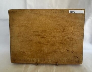 Greensborough Historical Society
Domestic object - Chopping Board, Wooden cutting board, 1900s
Board owned and used by Norma and Jim Petts, long standing residents of Greenhill Road, Greensborough 1951-2000.Small wooden rectangular board. Worn (concave in centre)chopping board, petts family, kitchen equipment -
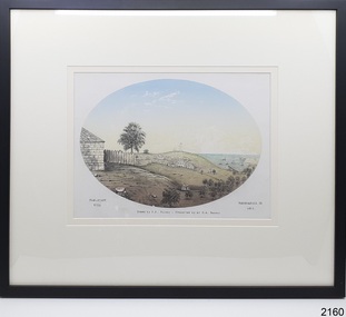 Flagstaff Hill Maritime Museum and Village
Drawing - Historical, Warrnambool, H. H. Ramsay, Flag-Staff Hill
The drawing is an artist's impression of Flagstaff Hill, Warrnambool, in 1855. It was presented to Flagstaff Hill Maritime Village by Mr R A Ramsay.The drawing is significant for its subject, a local maritime village and port. It is significant as a depiction of what the young town of Warrnambool could have looked like in 1855. Drawing in colour within an oval, with typed inscription below it. Mounted behind glass in a black rectangular frame with a cream matte. Artist's impression of Flagstaff Hill, town buildings of Warrnambool, Lady Bay with jetty, sailing ships in the bay, and Middle Island in the year 1855. Title; "Flag-Staff Hill", Artist; H. H. Ramsay It was presented to Flagstaff Hill by Mr R A Ramsay. Typed below the drawing; Left: "FLAG-STAFF HILL". Centre: "Drawn by Mr H. H. Ramsay - Presented by Mr R. A. Ramsay." Right: "WARRNAMBOOL IN 1855" On the back in pen "REC / 359A" (sighted before reframing)flag-staff hill, warrnambool 1855, drawing, local history, flagstaff hill maritime museum and village, great ocean road, shipwreck coast, h h ramsay, r a ramsay, flagstaff hill, warrnambool, flagstaff hill maritime museum, flagstaff hill maritime village, maritime museum, lady bay, middle island, coloured drawing, oval drawing -
 Glen Eira Historical Society
Book - Thomson Memorial Presbyterian Church Ormond, The Ormond Faith Story - The History of the Ormond Uniting Church - Centenary Edition 1903-2003
Two items relating to the Ormond Uniting Church (former Thomson Memorial Presbyterian Church): 1/ a book named "The Ormond Faith Story - The History Of The Ormond Uniting Church From 1903 – 2003 Centenary Edition". The front cover includes a colour photograph of the Church and the back cover includes a list of the Ministers during that time period. The Contents include several black and white photographs and an Appendices written by Rev Bill Morgan, Rev. Rod Horsfield, Rev. Robert Mcutchen and Rev. John Lamont, on what Ormond means to them. A black and white photograph of three ladies inscribed on the back as "Ormond Uniting Church Drop-in Centre, Cnr North & Booran Rds., Caulfield. Sept 84"A5-sized printed book of 64 pages plus colour back (photos of 9 men around Uniting Church insignia)and front (in red border is a colour photo of the Church) covers, with black and white images on the inside of these covers. It is mostly printed text with a number of black and white photos.ormond uniting church, anthony street, centenary edition, merton hall, anglican, maud street, presbyterian, wheatley road, methodist, ocean street, saint cuthberts, beattie james rev., jones hugh rev, chalinor john rev., hadley vincent rev., broughton david rev., morgan william rev., mcutchen robert rev., lamont john rev., horsfield rod rev., tregear george rev., kirkside independant living units, uniting church inaugurated, kids of the uniting church australia, kuca, after school program, saint kevins catholic church, father crimin, caulfield adult learning centre, daley daniel rev., green kevin rev, probin david rev, glen orme avenue, ormond, caulfield, plaza cinema, north road, manse, booran road, sunday school, glen orme, ladies church aid, ladies guild, dromana, playgroup, ucaf, booran road hall, fraser street hall, mordialloc, ormond park, new hall, reid christina rev., lamont john rev, cricket, tennis, glen orme avenue methodist church, ormond presbyterian church, st kevin’s catholic church, glen huntly presbyterian church, malane's corner, market gardens -
 Glen Eira Historical Society
Newspaper - CAULFIELD RSL
... Senior Citizens Centres St. George’s Road Elsternwick ANZAC Day ...This file contains five items of newspaper articles pertaining to the Caulfield RSL: 1/A pamphlet titled ‘A Chance to Honour – The Men Who Saved Australia’, date and parent organisation unspecified, advertising a presentation ceremony and film screening of Chris Masters’ documentary The Men Who Saved Australia to take place on 21/10/2005, to mark the 60th anniversary of the end of WWII. Included are two sepia photographs of the 39th Victorian Battalion – the first of them travelling up the Kokoda Track and the second of them parading after being relieved by the 7th Division – and one colour photograph of Michael Danby MHR, Federal Member for Melbourne Ports, attending the 2005 Anzac Day service in Port Melbourne. 2/A clipping from the Caulfield/Glen Eira Leader (Titled ‘Conflict of war continues’, dated 09/11/2010, and authored by Jenny Ling) advertising the year’s Remembrance Day service to be held by the Caulfield RSL on 07/11/2010/ Special tribute is to be paid to service persons killed in Afghanistan. (There exists a discrepancy between the date offered for the article, which is written on the page to which the clipping is attached, rather than the clipping itself, and the date offered for the event, which is written in the clipping itself. The event is described as taking place before the publication of the publication of the article advertising it. Presumably, the date offered for the article, written on the page to which the clipping is attached, is erroneous). 3/A clipping from the Caulfield Leader (titled ‘Our True Anzac Spirit’, dated 19/04/2011, and authored by Jenny Ling) noting that the New Zealand national anthem is to be played alongside Advance Australia Fair at all RSLs across Victoria on Anzac Day following lobbying by the Caulfield branch. Included is a colour photograph of New Zealand sub-branch vice-president Danny Allen and president Sam Smith standing in front of the New Zealand flag. 4/A clipping from the Caulfield Leader (titled ‘Veteran’s Vivid Memory’, dated 08/11/2011, and authored by Jenny Ling, consisting of a short biography of WWII veteran Eric Sparks. Included is a colour photograph of Sparks. 5/A clipping from the Melbourne Weekly Bayside – Your Community Voice (titled ‘Sun Up and Two-Up’, dated 18/04/2012, author unspecified) noting a visit to the Caulfield RSL by WWII veteran John Supple, and advertising a service to be held by the RSL on 25/04/2012. Included is a colour photograph of Supple outside the RSL.caulfield, caulfield returned servicemen league (rsl), exservice organisations, clubs and associations, returned servicepeople, armed forces, soldiers, aged people, senior citizens centres, st. george’s road, elsternwick, anzac day, memorial services, moore alan ‘kanga’, danby michael mhr, masters chris, ling jenny, sammon jason, larkin bob, gutnick dovid, remembrance day, blore jeff, mcbean jon, allen danny, smith sam, stewart mark, spark eric, spark eric ‘ned’, elder vin, supple john -
 Vision Australia
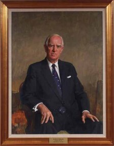
Painting - Artwork, Portrait of John Wicking, 1980
Framed portrait of John Wicking who was President of the Association for the Blind 1973-1984 as well as a generous benefactor. It is part of a series of paintings commissioned by the AFB Board to commemorate the work of past presidents of the organisation. Mr. Wicking wears a navy suit, white shirt and navy blue Kiwi tie. He was Managing Director and Chairman of Kiwi International when he was introduced to the Committee in 1971. With a natural air of authority, he was known to be both strong and wise. One of the first hurdles Mr Wicking faced following his election as President in 1973 was understanding the health service system and sorting out the differing views of committee members over recommendations for projects costing hundreds of thousands of dollars with no funds to implement them. The ten years of his Presidency were a time of exceptional growth and expansion. He was instrumental in acquiring an adjacent property to those already owned in Glenferrie Road in 1974 at a cost of $120,000, on which the Low Vision Clinic was erected – the first of its type in Australia. Land was also bought in both the metropolitan and country areas for future expansion. Day care centres were opened in Ballarat and Bendigo and new metropolitan services commenced. Mr Wicking formed a committee to explore the possibility of a radio station people unable to read standard print. As a result 3RPH commenced broadcasting in 1981. After his retirement as President, Mr. Wicking continued as a committee member until 1994. In 1995 he was instrumental in the establishment of the Tilly Aston Heritage Collection, on which he served as Chairman until sadly passing away in 2002. 1 art original in old gold frameThe plaque at the base of the painting reads 'Mr John O. Wicking AM / President 1973-1984 / Association for the Blind'. association for the blind, john wicking -
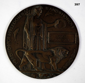 Bendigo Military Museum
Memorabilia - MEMORIAL PLAQUE, Post WW1
Samuel Marshall No 11/1925, 2nd Battalion Otago Regt New Zealand Expeditionary Force, KIA 15.9.1916. Buried Bulls Road Cemetery Flyers.111.F.20. Son of Mr & Mrs A.G.Marshall of 168 Bridge Street Bendigo Vic.Commemorative Bronze plaque for Samuel Marshall (Killed In Action) WW1 Centre of Plaque is Brittania with Lion & Seals Rectangular section for Individuals Name.He died for Freedom and Honour " Samuel Marshall"commemorative military, plaques -
 Melbourne Tram Museum
Photograph - Cable trams Victoria Parade Collingwood, c1923
The photograph shows Victoria Parade Collingwood looking east just before Cambridge St, with two cable trams in the view. Shows the layout of Victoria Parade with the cable trams in the centre of the northern part of the road. In the view is the Baden Powell Hotel. Same hand writing on the rear as item 8279.Yields information about Victoria Parade c1923. Black and white photo with hand written notes on the rear. Printed on Kodak paper."Melbourne cable trams about 1923"tramcars, tramways, cable trams, victoria parade -
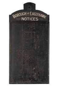 City of Greater Bendigo - Civic Collection
Sign - Borough of Eaglehawk Notices, Borough of Eaglehawk, Unknown
This notice board was used by the Borough of Eaglehawk to inform the community about services and events taking place in the local community and was hung in the Town Hall. Eaglehawk was first incorporated as a borough on 29 July 1862. It had nine councillors, who represented the entire borough. Councillors met at the Town Hall (incorporating the Star Cinema) at the intersection of Sailors Gully Road and Loddon Valley Highway, Eaglehawk. The Town hall has always been the centre of the Borough's activities and was built in 1901 on the site of an earlier town hall which had stood on the location since 1865. The Victorian Heritage Database notes: "The present building replaced this earlier building and was opened on 14 August 1901. The architects were the Melbourne firm of Wilkinson and Permewan. As a much larger and more sumptuous building of brick and stone featuring a central clock tower, the new hall reflected prevailing architectural fashion and was a remarkable investment for a town consisting predominantly of poor mining families. The condition of the town hall is substantially as built. The design is almost identical to the Castlemaine Town Hall." Eaglehawk was a local government area which covered the northwestern suburbs of the regional city of Bendigo and covered an area of 14.54 square kilometres (5.6 sq mi). On 7 April 1994, the Borough of Eaglehawk was abolished, and along with the City of Bendigo, the Rural City of Marong and the Shires of Huntly and Strathfieldsaye, was merged into the newly created City of Greater Bendigo.Handmade wooden notice board. Wood is roughly hewn and painted black with painted silver text. The front of the board is covered in pin holes. borough of eaglehawk -
 Bendigo Historical Society Inc.
Document - ALBERT RICHARDSON COLLECTION: VICTORIA HILL IRONBARK
Three page document hand written by Albert Richardson, on the history of Victoria Hill, Ironbark. 'one of the richest areas on Bendigo field. In the first six years, £1,200,000 worth of gold was obtained. Almost every claim returned a fortune.' Page three title: Other features on Victoria Hill. 'Adjacent to Central Nell Gwynne area as the mining museum. Adjacent to the New Chum Hill on direct south side of the Calder Highway. This hill reached by a short and excellent access road gives a magnificent view of Bendigo and Golden Square, and a very good view of another tourist attraction, Lansells 'Fortuna' now Survey Regiment's headquarters. This hill is the centre of another rich area. The Lazarus mine 3,360 feet deep with 24 saddle reefs in 2,200 feet. The New Chum United, Lansell's 222with its 120 ft high poppet legs. BCV 8, John Brown Knitwear factory, Esposito's Gold Mines Hotel, Central Nell Gwynne and Manchester tram loops are mentioned.Albert Richardsonbendigo, mining, victoria hill