Showing 1565 items
matching development buildings
-
 Southern Sherbrooke Historical Society Inc.
Information Folder - St. Martin's Church, Belgrave South & Heights
... Of The Original St Martins Church & Church Hall Buildings... Of The Original St Martins Church & Church Hall Buildings ...Information folder containing items pertaining to the history of St. Martin's Church, Belgrave South & Heights. Contents:- -photocopy of photo of St. Martin's Church at Belgrave South, with woman and pram outside. -information sheet - A Short History Of The Original St Martins Church & Church Hall Buildings and their Development To Become The Home Of The Southern Sherbrooke Historical Society -Invitation to opening of Southern Sherbrooke Historical Society's home, 4th March 2001 -article, "Church in heritage area", Free Press, 12 July 1995 (2 copies) -article, "St Martins moves from South to Heights", The Yarra Ranges Trader, 11 July 1995st. martins church -
 Southern Sherbrooke Historical Society Inc.
Information folder - Glen Park
Folder containing information pertaining to the history of Glen Park homestead, Menzies Creek. Contents: -two pages photocopied from "That Little Train" by Peter Cuffley, showing four photos of Glen Park homestead and a short history of Edwin Johns at Glen Park (2 copies of each) -articles, "No. 861's full steam ahead again", photo shows Col Rees with Coonara Community School students, and "Living the dream" re. engine no. 861. On verso, "A Family Reunited", article by Emerald Tourist Railway re. locomotives, and "Colin just loves steam locomotion" re. engine no. 861. -4 letters, from Puffing Billy Railway, in support of Col Rees. -Letter, dated 19 June 1996, from Emerald Tourist Railway, re. appeal for restoration of Garratt engine. On verso, copy of certificate awarded to Col Rees for donation to appeal. -Letter, 1 June 1998, re. Garrett appeal. On verso, certificate awarded to Col & Kellie Rees for donation to appeal. -Aerial photo showing proposed property boundaries of Glen Park subdivision. -Aerial photo showing existing property boundaries of Glen Park. NB. last four items provided to society by Col Rees in support of subdivision. -Memorandum dated 2 May 2000 from Graham Whitt, Shire of Yarra Ranges, to Shire Service Centres, re proposed division of Glen Park land. -Fax, dated 13 June 2000, from Southern Sherbrooke Historical Society to Shire of Yarra Ranges, re. intention to make submission. -Letter, dated 14 June 2000, acknowledging receipt of above fax. -Submission, dated 18 June 2000, from Southern Sherbrooke HS, expressing concern re. proposed subdivision of Glen Park. -Fax, dated 27 June 2000, from Dianne Kueffer to Susan Heywood-Downard, Agenda Item 2 of the Yarra Ranges Planning Committee Agenda 14 March 2000, including detailed description of proposed subdivision and map. -Letter, dated 7 July 2000, Shire to Society, re. discussion of Glen Park subdivision by council. -Letter, dated 7 July 2000, Society to Shire, re. withdrawal of objection subject to certain conditions. -Letter, dated 14 July 2000, Shire to Society, re. council resolution to allow subdivision of Glen Park. -Letter, dated 24 October 2000, Shire to Society, stating that amendment to Planning Scheme allowing subdivision was approved by council and gazetted on 19 October 2000. -seven A3 sheets, showing house and property plans for new constructions proposed for Lot 1 of Glen Park subdivision. -diagram, hand-drawn (by Col Rees?) on lined A4 sheet, showing proposed development. -A1 sheet, Plan of feature survey of Lot 2 Blackhill Rd, Selby, dated 12 April 2000, showing contours, vegetation, proposed location of buildings, etc. -Glen Park Homestead and Cyprus Avenue, document prepared for the Shire Of Yarra Ranges by Helen Lardner Conservation & Design P/L, June 2003edwin johns, breen family, col & kellie rees, puffing billy -
 Department of Health and Human Services
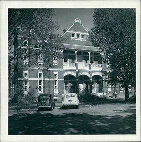
Photograph, 2 cars - An Austin & an early model Holden parked on Windermere St., outside Ballarat Base Hospital 13/02/1959 - Regional & District Hospital Collection - Department of Health & Human Services (DHHS)
... Photo is part of the Department of Health, Building..., Building & Services Division, Facilities Development - Hospitals ...Photo is part of the Department of Health, Building & Services Division, Facilities Development - Hospitals - Photographic Inventory -
 Department of Health and Human Services
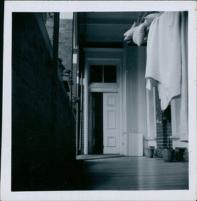
Photograph, Bedding being aired on the North verandah, looking East, on the ground floor of the Ballarat Base Hospital, photo take on 13/02/1959 - 4 of 4 photos - Regional & District Hospital Collection - Department of Health & Human Services (DHHS)
... Photo is part of the Department of Health, Building..., Building & Services Division, Facilities Development - Hospitals ...Photo is part of the Department of Health, Building & Services Division, Facilities Development - Hospitals - Photographic Inventory -
 Department of Health and Human Services
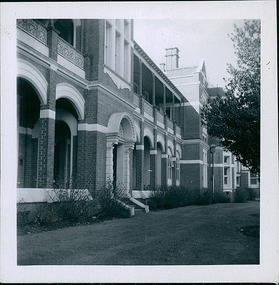
Photograph, The front facade, built in 1899, showing the existing elevation, of the Queen Victoria Ward, originally 'the women's ward', Ballarat Hospital in September 1957 - Regional & District Hospital Collection - Department of Health & Human Services (DHHS)
... Photo taken by the Department of Health - Building... - Building & Services Division - Facilities Development - Ballarat ...Photo taken by the Department of Health - Building & Services Division - Facilities Development - Ballarat Hospital - September 1957 -
 Department of Health and Human Services
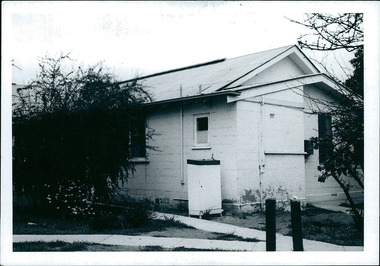
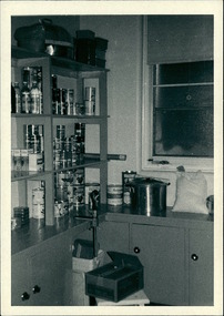
Exterior photo of the childrens' ward bathroom at Cohuna District Hospital. Photo was taken circa September 1969 - Regional & District Hospital Collection - Department of Health & Human Services (DHHS)
... Photo is part of the Department of Health, Building..., Building & Services Division, Facilities Development - Hospitals ...Photo is part of the Department of Health, Building & Services Division, Facilities Development - Hospitals - Photographic Inventory -
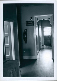 Department of Health and Human Services
Interior – 2 of 2 - Hallway - Views of the hallway with room service board near phone bell – Redcliffs District Hospital buildings - Regional & District Hospital Collection - Department of Health & Human Services (DHHS)
... Photo is part of the Department of Health, Building..., Building & Services Division, Facilities Development - Hospitals ...Photo is part of the Department of Health, Building & Services Division, Facilities Development - Hospitals - Photographic Inventory -
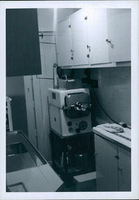 Department of Health and Human Services
Interior – Surgical Instruments - View of the autoclave which is used to sterilize surgical instruments – Redcliffs District Hospital buildings - Regional & District Hospital Collection - Department of Health & Human Services (DHHS)
... Photo is part of the Department of Health, Building..., Building & Services Division, Facilities Development - Hospitals ...Photo is part of the Department of Health, Building & Services Division, Facilities Development - Hospitals - Photographic Inventory -
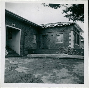 Department of Health and Human Services
1 of 3 photos - Hospital entrance with new addition of the front day room under construction at the Alexandra District Hospital. Photo taken in March 1978 - Regional & District Hospital Collection - Department of Health & Human Services (DHHS)
... Photo is part of the Department of Health, Building..., Building & Services Division, Facilities Development - Hospitals ...Photo is part of the Department of Health, Building & Services Division, Facilities Development - Hospitals - Photographic Inventory -
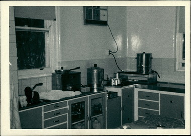 Department of Health and Human Services
Interior - Photo of interior of kitchen, hot water urns, air conditioning unit, at Alexandra District Hospital. Photo take in March 1978 - Regional & District Hospital Collection - Department of Health & Human Services (DHHS)
... Photo is part of the Department of Health, Building..., Building & Services Division, Facilities Development - Hospitals ...Photo is part of the Department of Health, Building & Services Division, Facilities Development - Hospitals - Photographic Inventory -
 Department of Health and Human Services
Interior - Photo of interior of kitchen at Alexandra District Hospital. Photo take in March 1978
... Photo is part of the Department of Health, Building..., Building & Services Division, Facilities Development - Hospitals ...Photo is part of the Department of Health, Building & Services Division, Facilities Development - Hospitals - Photographic Inventory -
 Department of Health and Human Services
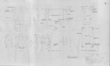
Photograph, Architectural drawing, provided by the Department of Public Works, of an autopsy table for Ballarat Mental Hospital. The plan is dated 09/01/1959 - Regional & District Hospital Collection - Department of Health & Human Services (DHHS)
... Photo is part of the Department of Health, Building..., Building & Services Division, Facilities Development - Hospitals ...Photo is part of the Department of Health, Building & Services Division, Facilities Development - Hospitals - Photographic Inventory -
 Southern Sherbrooke Historical Society Inc.
Information folder - Madigan Cottage
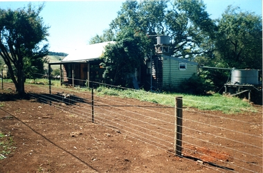
The buildings are probably rare remnant examples of their type in the local area and as such are significant to the settlement of Menzies Creek. The dwelling is significant as a longstanding marker of the Madigan family who were original settlers in the area. Its retention in its site close to the road boundary expresses and maintains a connection with early settlement and rural lifestyles in Menzies Creek over the last century. The old shed is of interest as a local example of bush construction, particularly in context with the cottage and farm environs. Without the life of the farm and other elements presumed now gone, its value is lessened.Folder containing information pertaining to the history of Madigan Cottage, Menzies Creek. NB: the shed was demolished in November 2001 and the cottage burned down sometime later. Contents:- Letter, Southern Sherbrooke Historical Society to Shire of Yarra Ranges, dated 9th March 2001, re. sale of property and need for it to be included in shire's Heritage Study. -Letter, shire to society, dated 20th March 2001, reply to above. -Letter, shire to society, dated 15th May 2001, follow-up to above, requesting more information. -Letter, society to shire, dated 30th May 2001, responding to above and including a copy of information previously sent to Chris Johnston, Heritage Study consultant. -Letter, society to shire, undated, noting intention to lodge an objection to proposed application for development on site. -Letter, shire to society, dated 22nd October 2001, advising of consultation meeting. -Yarra Ranges Shire Heritage Study Place Nomination form for Madigan Cottage, prepared by Marian Matta, includes nine colour photos and diagram showing where photos were taken from. -Black and white copies of photos. -A3 copy of real estate advertisement, "Mount Evergreen Estate" dated 21st April 1924. -A3 map showing proposed resubdivision boundary variation, drawn up for Mr. P. Melville, undated but 1990s. -Copy of application for a planning permit, dated 6th August 2001, including letter by Nick Jonkers describing proposed new buildings, site map showing current vegetation, letter re. proposed removal of vegetation, subdivision plan dated March 1998, and larger scale map printed from shire website on 10th August 2001. -5 A3 sheets showing site and house plans drawn up for Mr & Mrs N. Jonkers, dated July 2001.madigan cottage, menzies creek, madigan family, mount evergreen, patrick madigan -
Southern Sherbrooke Historical Society Inc.
Document - Information folder - proposed Demas Construction development at Belgrave South, 1976
Information folder containing items [pertaining to the proposed building of a boutique shop complex on the south-eastern corner of Belgrave-Hallam Rd and Temple Rd, Belgrave South, in 1976. Contents: -Town Planning Appeals Tribunal, Appeal No. X76/455, Application No. 2437, dated 24th August 1976. 11 sheets of foolscap. -
 Ballarat Tramway Museum
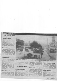
Newspaper, The Courier Ballarat, "In Retrospect", 20/09/1994 12:00:00 AM
Newspaper cutting from The Courier, Ballarat, Tuesday 20/9/1994 of the reproduction of a postcard photograph showing an ESCo tram soon after opening running west bound in Sturt St with the Town Hall in the background. Shows the development of the Gardens at the time and buildings on either side of Sturt St. and type of poles etc. The tram is fitted with a destination board on the front dash - the type used soon after opening in 1905. Caption of the photo says "Trams run up Sturt St and people relax in this postcard sent in December 1907. Ballarat's Town Hall is pictured at right." Also has an item in the "In Retrospect" section of the newspaper, about the construction of a new road to avoid two level crossings between Talbot and Clunes. Item compiled by Lorrie BrownIn bottom right hand corner, in blue ink "Tues 20/9/94".trams, tramways, sturt st, esco, town hall -
 Ballarat Tramway Museum
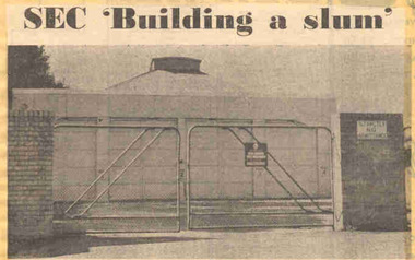
Newspaper, The Courier Ballarat, "SEC 'Building a slum' ", 20/02/1972 12:00:00 AM
Newspaper clipping from The Courier, Ballarat, dated Monday 20/3/1972, titled "SEC 'Building a slum' ". Item with a photo about the proposals of the SEC to convert the former tram depot land to development comprising 16 houses as a built-in slum. The development was considered inappropriate for the area by local residents, who requested a development of 6 lots. Features a photo of the depot building with locked gates and a Security company sign on the gate. One of large group of newspaper cuttings from John Bainbridge, 7/4/02.depot, sale of land, wendouree parade -
 Ballarat Tramway Museum
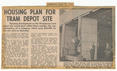
Newspaper, The Courier Ballarat, "Housing plan for tram depot site", 19/06/1972 12:00:00 AM
Newspaper clipping from The Courier, Ballarat, dated Monday, June 19, 1972 titled "Housing plan for tram depot site". Reports on the sale of the former tram depot on Saturday June 17 for $54,500. The purchaser expected to start development of housing on the site within three months. Reports on the sale, purchaser and SEC's views. Features a photo of Edgar Bartrop reading the contract. Others in the photo are Bruce Bartrop, SEC Estate officer, Mr. R. Morrison and SEC Manager Mr. I. F. Pellas. One of a large group of newspaper cuttings from John Bainbridge, 7/4/02.depot, buildings, auctions, bartrop -
 Ballarat Tramway Museum
Document - Photocopy, M. Sayers, "The Development of Ballarat's Electricity Supply", 2000?
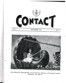
2971.1 - Photocopy of the cover of the State Electricity Commission of Victoria Magazine, Contact, Vol 3, No. 3, Nov 1938 . Features Miss Winifred Gurr of the Queenscliff office, as the Good Fairy, Electricity at the Geelong Centenary Celebrations. Has the SEC logo or motif on the top of the cover. 2971.2 - Photocopy of an article in the State Electricity Commission of Victoria Magazine, Contact, Vol 3, No. 3, Nov. 1938 titled "The Development of Ballarat's Electricity Supply". One A3 sheet and one A4 sheet. The article details the SEC's part in the celebration of Geelong's Centenary Celebrations in October 1938. Opened by Mayor, Alderman C. N. Brown. Details the lighting needs for the celebrations, 400kW, the large motor traffic who came to see them, damage due to Gales, public buildings illuminated and the procession. Includes details of the decorated trams - 1500 paper floors and 400 lamps. Has photos of Moorabool St, a decorated Pengelly tram and Power Station. On page 4 is a letter from an American visitor, Dorothy Bradner congratulating the tramways. Record revised 3/4/2019 to add digital images with those from Andrew Cook CD. Images added of pages 22 and 37 Page 22 - image 12 - titled "The Provincial Big Three" - photos of the Managers of the Ballarat, Geelong and Bendigo Regions - Mr. T. A. Farr, Mr. H.N. Hornabrook and T.H. McNaught. Page 37 - image 11 - Staff movements of General Interest - records the retirement of W. White Tramways Inspector Geelong, and appointments - W. J. McKinnon appointed as Tramway Inspector and Mr. C. S. Ball, appointed Senior Traffic Inspector. Each item had a thin strip of paper attached by staple to the top left hand corner, giving the Vol. No. details. trams, tramways, sec, geelong, geelong centenary, power station, decorated trams, letters -
 Ballarat Tramway Museum
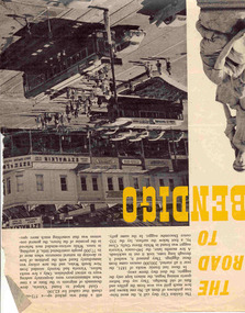
Newspaper, The Walkabout Magazine, "The Road to Bendigo", Oct. 1974
Yields information about the final day of the Bendigo tramways and some of the tramcars used.Three double sided sheets from "The Walkabout" magazine, October 1964, titled "The Road to Bendigo". Five printed pages featuring photographs of Bendigo, its buildings, its history stories, gold mining days and other information, including three illustrations containing trams. .1 - Charing Cross with bogies and single trucker - taken early 1960's. Photo by A. Doney. Features the intersection, with Ezywalkin store. Note the "Jeffrey's bread" roof advertisement on the single trucker. .2 - Bogie tram on the Eaglehawk route prior to any nearby housing development - reclaimed mining land - has Castrol roof advertisement - photo by Claver P Carroll. .3 - No. 6 outside The Beehive stores - 3BO - photo by Claver P Carroll. bendigo, eaglehawk, charing cross -
 Ballarat Tramway Museum
Document - Photocopy, M. Sayers, "The Development of Ballarat's Electricity Supply", 2000?
Photocopy of an article in the State Electricity Commission of Victoria Magazine, Contact, Vol 3, No. 2, Aug 1938 titled "The Development of Ballarat's Electricity Supply". Two A3 sheets. The item with six photographs details the history of the development of Ballarat's Power Supply. Details development of the initial power supply in Dana St, the take over by ESCo, DC power initially, expansion, introduction of AC in 1925 to Ballarat, the takeover by the SEC in 1934, changeover from DC to AC, expansion to outlying areas, Buninyong, Creswick etc. Gives description of installed plan, boilers, storerooms and the stores systems. Has photos of the Dana St. building, Ballarat A power station, Ljungstrom Turbo Alternator and three of the stores area. Record revised 3/4/2019 to add digital images with those from Andrew Cook CD. Each item had a thin strip of paper attached by staple to the top left hand corner, giving the Vol. No. details.On rear of 2nd A3 sheet in blue ink details of contact with the BTM by M. Sayers prior to sending the material.trams, tramways, sec, power supply, power station, ballarat a power station, esco -
 Ballarat Tramway Museum
Newspaper, The Courier Ballarat, "Tramway museum on track" - "funding sought for tourist attraction development", 28/03/2014 12:00:00 AM
Newspaper clipping from The Courier, Friday 28/3/2014, page 7, titled "Tramway museum on track" - "funding sought for tourist attraction development", with an image of the Museums plan for the addition to the existing building. Includes information provided by Paul Mong, business case, creating jobs. Two copies collected.On front or rear of the cutting, information re dates etc.btm, museum -
 Bendigo Historical Society Inc.
Document - PHOTO RECORD OF THE FORMER LYRIC THEATRE
Spring bound photographic record of the former Lyric Theatre, 19 High Street (Charing Cross), Bendigo, by Bruce Trethowan, B.arch, FRAIA, dated June, 2005. A letter in the front of the document mentions as part of the Bendigo Bank Development, it was necessary to demolish the former Lyric Theatre. Before doing so, the Bank commissioned a heritage architect to produce a photographic record of the building. It is addressed to Mr Jim Evans, President, Bendigo Historical Society and dated 10 August 2005. The beginning has the Historical Background, Building Description and three pages of Plans and Elevations. There are sixty colour photographs of the building depicting the front outside of the building, other outside photos and a number of the interior.buildings, commercial, former lyric theatre, photographic record of the former lyric theatre, bruce trethowan, gallagher jeffs consulting, gallagher jeffs pty ltd, jim evans, bendigo bank development, ted gallagher, richard hasseldine, city of greater bendigo planning department, keogh & austen, state savings banks, sydney smith and ogg, godfrey and spowers, colonial life building, johnson morley warehouse, j g austen, muioof building eaglehawk, george austen, backhaus building, allawah, william cowling, taylor, soilleux, overend, plaza theatre, backhaus trust, princess theatre, the annals of bendigo vol 8 p163, the annals vol 8 p180, fernwood women's health club, bendigo real estate -
 Bendigo Historical Society Inc.
Book - CENTRAL DEBORAH MINE CORRESPONDENCE RE PLANT DEVELOPMENT PART 2
Black folder containing photocopied documents pertaining to the setting up and running of the Central Deborah Mine, Bendigo. 1939 - 1948. Original copies held in McColl,Rankin & Stanistreet Collection. Application for Permit. Ministry of Post War Reconstruction. War Organisation of Industry. Quotes, Tenders. Hume & Iser. T.J Jorgensen. Electricity Supply Department. Saunders & Ross. District Telephone Office. R Toma. Stock Exchange. Building Site Plan. Abbott Supply Co. F.W. Milne & Son. The Golden City Agricultural Implements. Department of Labour and National Service.Miller & Co. Thompson Engineering and Pipe Co. Gold Boring and Prospecting. Costs. J.l. Howard. A.J. William Electrical Instruments.bendigo, mining, central deborah gold mine -
 Bendigo Historical Society Inc.
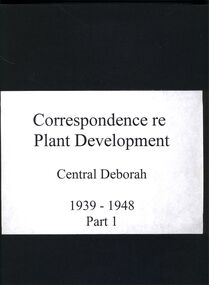
Book - CORRESPONDENCE RE PLANT DEVELOPMENT CENTRAL DEBORAH PART 1, 1939 - 1948
Four ring binder containing correspondence re plant development Central Deborah Mine Bendigo 1939 - 1948 part 1, McColl Rankin Stanistreet Solicitors, Mining box 1.Newspaper clipping Bendigo Weekly Friday September 2 2016 referring to the construction of a modern office building at View point, 4 floors and have a lift(elevator), called Commercial House later becoming Cahill Chambers. Mosaic 5834 linkbook, bendigo, mining, history-bendigo-mining -
 Bayside Gallery - Bayside City Council Art & Heritage Collection
Map - print, Melbourne and Metropolitan Board of Works, Interim development order: Brighton, Moorabbin and Sandringham, 1959
The Melbourne and Metropolitan Board of Works (now Melbourne Water) was established in 1891. From that time, as part of their work laying water and sewerage connections, they created detailed plans of houses and other buildings in the Melbourne metropolitan area. In 1956 it acquired powers to construct and maintain highways and bridges, protect and improve the foreshores and create and maintain parks within the metropolitan region. This Interim development order comprises part of the municipalities of Brighton, Moorabbin and Sandringham and was made on 20 October 1959.brighton, moorabbin, sandringham, melbourne and metropolitan board of works, map, town planning, cartographic material, interim development order, bayside -
 Bendigo Historical Society Inc.
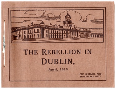
Document - The Rebellion in Dublin, April, 1916
The Easter Rising also known as the Easter Rebellion, was an armed insurrection in Ireland during Easter Week in April 1916. The Rising was launched by Irish republicans against British rule in Ireland with the aim of establishing an independent Irish Republic while the United Kingdom was fighting the First World War. It was the most significant uprising in Ireland since the rebellion of 1798 and the first armed conflict of the Irish revolutionary period. Sixteen of the Rising's leaders were executed starting in May 1916. The nature of the executions, and subsequent political developments, ultimately contributed to an increase in popular support for Irish independence.The Six Days' of Rebellion in Dublin - Photo album type book with story of the rebellions and original photos of the damage inflicted on the streets of Dublin. Published by Eason and Sons Ltd., Dublin and Belfast.Inside the front cover: To Pa love from ??. The buildings are shown just as they are at present - I have seen them all. Ireland 1/11/18history, irish rebellion, rebellion in dublin -
 Kew Historical Society Inc
Plan, Borough of Kew Detail Plan No.1577, 1904
The Melbourne and Metropolitan Board of Works (MMBW) plans were produced from the 1890s to the 1950s. They were crucial to the design and development of Melbourne's sewerage and drainage system. The plans, at a scale of 40 feet to 1 inch (1:480), provide a detailed historical record of Melbourne streetscapes and environmental features. Each plan covers one or two street blocks (roughly six streets), showing details of buildings, including garden layouts and ownership boundaries, and features such as laneways, drains, bridges, parks, municipal boundaries and other prominent landmarks as they existed at the time each plan was produced. (Source: State Library of Victoria)This plan forms part of a large group of MMBW plans and maps that was donated to the Society by the Mr Poulter, City Engineer of the City of Kew in 1989. Within this collection, thirty-five hand-coloured plans, backed with linen, are of statewide significance as they include annotations that provide details of construction materials used in buildings in the first decade of the 20th century as well as additional information about land ownership and usage. The copies in the Public Record Office Victoria and the State Library of Victoria are monochrome versions which do not denote building materials so that the maps in this collection are invaluable and unique tools for researchers and heritage consultants. A number of the plans are not held in the collection of the State Library of Victoria so they have the additional attribute of rarity.Original survey plan, issued by the MMBW to a contractor with responsibility for constructing sewers in the area identified on the plan within the Borough of Kew. The plan was at some stage hand-coloured, possibly by the contractor, but more likely by officers working in the Engineering Department of the Borough and later Town, then City of Kew. The hand-coloured sections of buildings on the plan were used to denote masonry or brick constructions (pink), weatherboard constructions (yellow), and public buildings (grey). MMBW Plan No.1577 includes some of the most significant houses in Kew: Herbert Henty’s ‘Roxeth’ (now part of Trinity Grammar), ‘Butleigh Wooton’, ‘Bokara’ and ‘Harrow’. It also includes the streets that have since changed their names. That part of College Parade linked to Glenferrie Road is now named College Place, College Parade now extends further north, and Charles Street did not yet reach Barkers Road. Roxeth is one of a number of Henty houses in Kew. Herbert Henty made his home here and was elected a member of Kew Municipal Council in 1864 and mayor in 1868-69. Walter Henry Serle, of Harrow served in the First World War. He was awarded the Military Medal ‘’For conspicuous bravery and devotion to duty. On 29th September near BELLICOURT he showed the greatest bravery and determination when his platoon was attacked by enemy bombing parties. It was due largely to his personal efforts that all the attacks were repulsed. Until wounded, his utter disregard of personal safety and boldness in dealing with the attacks were the means of saving the situation and were an inspiring example to his men.’melbourne and metropolitan board of works, detail plans, maps - borough of kew, mmbw 1577, cartography -
 Kew Historical Society Inc
Plan, Melbourne & Metropolitan Board of Works : Borough of Kew : Detail Plan No.1578, 1904
The Melbourne and Metropolitan Board of Works (MMBW) plans were produced from the 1890s to the 1950s. They were crucial to the design and development of Melbourne's sewerage and drainage system. The plans, at a scale of 40 feet to 1 inch (1:480), provide a detailed historical record of Melbourne streetscapes and environmental features. Each plan covers one or two street blocks (roughly six streets), showing details of buildings, including garden layouts and ownership boundaries, and features such as laneways, drains, bridges, parks, municipal boundaries and other prominent landmarks as they existed at the time each plan was produced. (Source: State Library of Victoria). This plan forms part of a large group of MMBW plans and maps that was donated to the Society by the Mr Poulter, City Engineer of the City of Kew in 1989. Within this collection, thirty-five hand-coloured plans, backed with linen, are of statewide significance as they include annotations that provide details of construction materials used in buildings in the first decade of the 20th century as well as additional information about land ownership and usage. The copies in the Public Record Office Victoria and the State Library of Victoria are monochrome versions which do not denote building materials so that the maps in this collection are invaluable and unique tools for researchers and heritage consultants. A number of the plans are not held in the collection of the State Library of Victoria so they have the additional attribute of rarity.Original survey plan, issued by the MMBW to a contractor with responsibility for constructing sewers in the area identified on the plan within the Borough of Kew. The plan was at some stage hand-coloured, possibly by the contractor, but more likely by officers working in the Engineering Department of the Borough and later Town, then City of Kew. The hand-coloured sections of buildings on the plan were used to denote masonry or brick constructions (pink), weatherboard constructions (yellow), and public buildings (grey). MMBW Plan No.1578 is significant in that it defines the extent of two private schools: Xavier College and Kew High School (now part of Trinity Grammar) by 1904. In relation to the latter, the plan clarifies which buildings the High School operated from behind the mansion ‘Molina’. Established in 1902, Trinity Grammar was to later lease and subsequently buy Molina (now ‘Merritt House’) and ‘Elsinore’ (now ‘Roberts House’). Xavier College had been established in 1872. This 1904 plan delineates the West Wing and the Great Hall (built in 1890).melbourne and metropolitan board of works, detail plans, maps - borough of kew, mmbw 1578, cartography -
 Kew Historical Society Inc
Plan, Melbourne & Metropolitan Board of Works. Borough of Kew Detail Plan No.1579, 1904
The Melbourne and Metropolitan Board of Works (MMBW) plans were produced from the 1890s to the 1950s. They were crucial to the design and development of Melbourne's sewerage and drainage system. The plans, at a scale of 40 feet to 1 inch (1:480), provide a detailed historical record of Melbourne streetscapes and environmental features. Each plan covers one or two street blocks (roughly six streets), showing details of buildings, including garden layouts and ownership boundaries, and features such as laneways, drains, bridges, parks, municipal boundaries and other prominent landmarks as they existed at the time each plan was produced. (Source: State Library of Victoria). This plan forms part of a large group of MMBW plans and maps that was donated to the Society by the Mr Poulter, City Engineer of the City of Kew in 1989. Within this collection, thirty-five hand-coloured plans, backed with linen, are of statewide significance as they include annotations that provide details of construction materials used in buildings in the first decade of the 20th century as well as additional information about land ownership and usage. The copies in the Public Record Office Victoria and the State Library of Victoria are monochrome versions which do not denote building materials so that the maps in this collection are invaluable and unique tools for researchers and heritage consultants. A number of the plans are not held in the collection of the State Library of Victoria so they have the additional attribute of rarity.Original survey plan, issued by the MMBW to a contractor with responsibility for constructing sewers in the area identified on the plan within the Borough of Kew. The plan was at some stage hand-coloured, possibly by the contractor, but more likely by officers working in the Engineering Department of the Borough and later Town, then City of Kew. The hand-coloured sections of buildings on the plan were used to denote masonry or brick constructions (pink), weatherboard constructions (yellow), and public buildings (grey). While MMBW Plan No.1579 does not include many buildings, those that it does show are significant to Kew’s history. These include the ‘Kew [Railway] Station’ in Denmark Street and the ‘Recreation Hall’ and rear courts off Wellington Street. The plan shows the outline of the Recreation Hall, constructed in 1880, at the rear of which is listed a bowling green, two tennis courts, a ‘skittle alley’ and a pavilion. When the Hall was first built, the Kew Cricket Club occupied an adjacent ground, however in 1885 this was acquired by the State Government as the future location of the Kew Railway Station. The Plan also shows a single oval at Xavier College. This oval was completed in 1883. One of the current ovals conforms to this oval’s original shape and position in the school grounds.melbourne and metropolitan board of works, detail plans, maps - borough of kew, mmbw 1579, cartography -
 Kew Historical Society Inc
Plan, Melbourne and Metropolitan Board of Works, Borough of Kew : Detail Plan No.1580, 1904
The Melbourne and Metropolitan Board of Works (MMBW) plans were produced from the 1890s to the 1950s. They were crucial to the design and development of Melbourne's sewerage and drainage system. The plans, at a scale of 40 feet to 1 inch (1:480), provide a detailed historical record of Melbourne streetscapes and environmental features. Each plan covers one or two street blocks (roughly six streets), showing details of buildings, including garden layouts and ownership boundaries, and features such as laneways, drains, bridges, parks, municipal boundaries and other prominent landmarks as they existed at the time each plan was produced. (Source: State Library of Victoria)This plan forms part of a large group of MMBW plans and maps that was donated to the Society by the Mr Poulter, City Engineer of the City of Kew in 1989. Within this collection, thirty-five hand-coloured plans, backed with linen, are of statewide significance as they include annotations that provide details of construction materials used in buildings in the first decade of the 20th century as well as additional information about land ownership and usage. The copies in the Public Record Office Victoria and the State Library of Victoria are monochrome versions which do not denote building materials so that the maps in this collection are invaluable and unique tools for researchers and heritage consultants. A number of the plans are not held in the collection of the State Library of Victoria so they have the additional attribute of rarity.Original survey plan, issued by the MMBW to a contractor with responsibility for constructing sewers in the area identified on the plan within the Borough of Kew. The plan was at some stage hand-coloured, possibly by the contractor, but more likely by officers working in the Engineering Department of the Borough and later Town, then City of Kew. The hand-coloured sections of buildings on the plan were used to denote masonry or brick constructions (pink), weatherboard constructions (yellow), and public buildings (grey). The area represented in this detail plan has undergone significant change during the 20th century. The widening of High Street in the 1930s and 1950s involved the shops on the south side of High Street being demolished and later rebuilt to fit the widened street. Another significant loss was the mansion ‘Drayton’ fronting Wellington Street, owned at this stage by Susannah Fenton. Her family name would later to be given to Fenton Way, which was to be built over the grounds of the house following its demolition. The plan of the garden is particularly interesting, containing a batten dome fronting Wellington Street, an ornamental pond, a fountain and a brick and glass conservatory. The notes by the plumbing contractor on this plan are particularly detailed. Pink borders delineate the ownership of the varying parcels of land. Some of the better known owners listed include the real estate agent Cr. Henry de Castres Kellett (bt) and John Padbury, the funeral director. This particular plan provides a clear view of the configuration of the Kew Junction in 1903 and the commercial buildings that surrounded it.melbourne and metropolitan board of works, detail plans, maps - borough of kew, mmbw 1580, cartography