Showing 2288 items matching " parish."
-
 Federation University Historical Collection
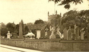
Postcard - Postcard - photographic, Edgbaston Old Church, Birmingham, c1917
Edgbaston Old Church is also known as St Bartholomew's Church, Edgbaston. The medieval church was largely rebuilt in the 19th century. A photographic postcard which shows the Edgbaston Old Church in the background with gravestones from the church graveyard in the foreground. The church is a Church of England parish church in the Church of England in Edgbaston, Birmingham.chatham-holmes family collection, edgbaston, cemetery, edgbaston old church, st bartholomew's, graveyard, church -
 Glen Eira Historical Society
Pamphlet - St. Agnes Church, Booran Road, 116, Glen Huntly
Parish of St Agnes October – November 2009 Messenger monthly magazine of church community calendar.murrumbeena craft and produce market, st. agnes parish, glen huntly, glenhuntly, booran road, the messenger, nickson lance, carter shirley, mothers’ union, n’diaye maree, churton marj, kennedy anne, clarke alice, worthington mary, cheshire jean, festivals and celebrations, moyes cliff fr., mackay mary, still family, still tom, burt maree, ngan ivan, evans beryl, young merna, faulkes betty, raw dorothy -
 Greensborough Historical Society
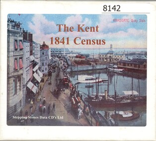
CD-ROM, Stepping Stones Data CDs Limited, The Kent 1841 census, 1841
CD set contains the 1841 census for Kent in Great Britain. It is searchable by Parish, township and hamlet. May assist in family history research.3 x CD-ROMs , contents note and instructions for use in boxcensuses great britain, kent england, family history -
 Linton and District Historical Society Inc
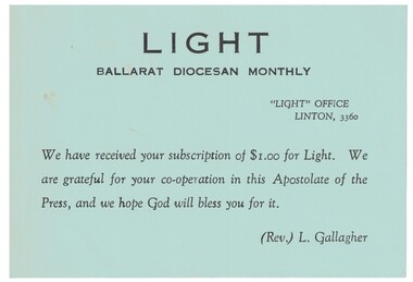
Receipt, Light Ballarat Diocesan Monthly
Rev. Fr. L. Gallagher, Parish Priest of Linton was the Manager of the Catholic Diocesan monthly magazine.Green receipt card for the Catholic magazine "Light" managed by Rev. Fr. Laurie Gallagher of Linton.Text: " LIGHT / BALLARAT DIOCESAN MONTHLY. "receipts, fr. laurie gallagher, magazines, 'light' [catholic church periodical], catholic church linton -
 Bendigo Historical Society Inc.
Document - BOARD OF WORKS, MELBOURNE: CONTRACTS ACCEPTED & LAND SALES FOR 1860
Page 2223 titled Contracts Accepted - (Series 1860). Contracts accepted are for Raising and removing sunken ship Marilla; Removal of Toll-gate from Mount Alexander Road and re-erection of same at Middle Gully; Erection of toll-house on Melbourne/Ballarat Road near Ballan; Erection of toll-house on Bendigo Road at Kangaroo Flat; Castlemaine to Ballarat - Erection of toll-house at Campbell's Creek; Construction of 2870 chains of Lower Western Road, west of Camperdown; Erection of two bridges and other improvements on the Clunes to Amherst Road; Erection of timber bridge, & c., over Two-mile Creek - Beechworth to Bowman Forest; Formation of roadway at head of Buckland Gap - Beechworth to Bowman Forest; Construction of culvert, & c., Rowe's Creek - Beechworth to Bowman Forest; Ararat and South-western sea-board road - erection of bridge over Dennicull Creek and other improvements. Land Sales - 4 Lots - Elsternwick, parish of Prahran, County of Bourke; 2 Lots - Dandenong, County of Bourke; 20 Lots - Lillydale, Parish of Yering, County of Evelyn, 1 suburban Lot - County of Evelyn, Parish of Yering; 1 Allotment - Romsey, County of Bourke, Parish of Lancefield; 5 Lots - County of Mornington, Parish of Langwarrin, and 2 Lots - County of Mornington, Parish of Fingal. Lots to be sold at the Auction Rooms of Mr. William Perry, Great Collins Street, Melbourne. A F A Greaves, President, Office of the Board of Land and Works, Melbourne.bridge, construction, timber bridges, board of works, melbourne - contracts accepted & land sales, 'marilla', f m pingree, jno r bailey, robert heron, john gray, donald ross, hector mclean, c j glynn and co, john nicholls and co, michael cleary, thomas cairncross, brown and gibson, queen victoria, mr william perry, mr de castella, willoughby, barker, a f a greeves, board of land and works melbourne -
 Bendigo Historical Society Inc.
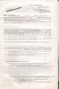
Document - MCCOLL, RANKIN AND STANISTREET COLLECTION: INDENTURE GOLD MINING LEASE 9201 BALLAARAT
6 page document plus map: indenture, gold mining lease dated 9th August 1960, between the Crown and North Deborah Mining Company, carrying on operations in the Parish of Moorarbool West . Key on map indicates depth to which land may be excised. On map: Mining District of Ballarat, County of Grant, Parish of Moorarbool West. Total area: 285 acres 1 rood, 20 perches. Vol 334, Fol 202.bendigo, mining, deborah gold mines -
Bendigo Historical Society Inc.
Map - CAMPBELL COLLECTION: BENDIGO AND DISTRICT MAPS
Map. Ellesmere, Parish of Ellesmere. Scale 20 chains to 1 inch. Total area 3926 acres. Prepared in W.P.B. from A and P plans. (number 354 in map cupboard 1)map, bendigo, agricultural lands -
Port Melbourne Historical & Preservation Society
Document - Newsletter, Parish Papers, Holy Trinity Anglican Church, Port Melbourne, 1971 - 1974
Six issues of the Parish Papers of Holy Trinity Church of England, Port Melbourne: 1971 - 1974. Photo of the church at upper left corner, showing picket fence and Bay Street entrance. religion - anglican (holy trinity), p a longford, mrs p harjes, shirley lawson, harriet hall, alice ruth sidwell, mrs l turner -
 Whitehorse Historical Society Inc.
Article, Court hears Priest's plea to stay at vicarage, 29/04/1997 12:00:00 AM
An Anglican ministerAn Anglican minister who claimed he was illegally sacked after a dispute in his parish was told by a Supreme Court judge yesterday that he might have some difficulty in staying in the vicarage.An Anglican ministergreentree, david, rev, vincent, frank, rayner keith, dr., st lukes anglican church, vermont, mackay, leigh, melbourne anglican trust corporation, symon, helen -
Whitehorse Historical Society Inc.
Document, What happened to Norwich?
Norwich, consisting of 475 acres in the Parish of Nunawading, County of Bourke, found on a land sale map in the La Trobe collection of Vale maps.Norwich, consisting of 475 acres in the Parish of Nunawading, County of Bourke, found on a land sale map in the La Trobe collection of Vale maps. Research by Jean Uhl into the fate of the proposed township.Norwich, consisting of 475 acres in the Parish of Nunawading, County of Bourke, found on a land sale map in the La Trobe collection of Vale maps. local history, uhl, jean, parish of nunawading, norwich village, vermont, lobb, john, graham, thomas -
 Whitehorse Historical Society Inc.
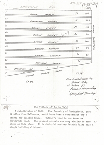
Document, Plan of Subdivision, 1861
Copy of plan of subdivision by Patrick RileyCopy of plan of subdivision by Patrick Riley of Section 77, Parish of Nunawading 'Springfield Township' 1861. Bounded by Whitehorse Road, Walker's Road, (now known as Springvale Road) and Springfield RoadCopy of plan of subdivision by Patrick Rileyland sales, riley, patrick, whitehorse road, nunawading, walkers road, springfield road, black street, robertson street, sandy street, burnt street, luckie street, bridge street, creek street, koonung street, thompson street -
Whitehorse Historical Society Inc.
Map, Applied for the Roman Catholic Church, 1848
Photocopy of manuscript map inscribed 'Reserve 40 Parish of Nunawading'.Photocopy of manuscript map inscribed 'Reserve 40 Parish of Nunawading'. Streets not named. Note on verso: Site reserved for Roman Catholic Church in Nunawading c1848 (Cr Riversdale and Warrigal Roads)Photocopy of manuscript map inscribed 'Reserve 40 Parish of Nunawading'. churches, catholic church, riversdale road, surrey hills, warrigal road, surrey hills -
 Whitehorse Historical Society Inc.
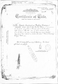
Certificate - Land Title Document, Crown Allotment, 24/9/1885
Certificate of Title dated 4/9/1885 covering land in Shady Grove Nunawading purchased by The Freehold Investment and Banking Company. Crown Allotment No. 116 Parish of Nunawading County of Bourkeland titles, shady grove nunawading no. 76, crown land allotment no. 116, the freehold investment and banking company of australia ltd., higgins, mary, holmes, dave, wilson, david duncan butchart, helen -
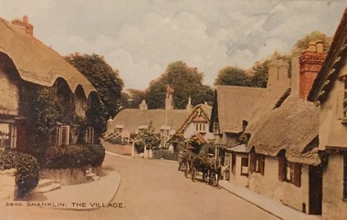 Kew Historical Society Inc
Postcard, Shanklin: The Village, c.1928
Collection of thirty-nine postcards donated by Jillian Rigby which had been owned by her grandparents, George and Edith Weir, who from c.1917 lived at 84 Princess Street, Kew. The mostly 'mint' postcards were purchased in Victoria and while travelling overseas. The sole dated postcard is dated from 1929. The postcards are numbered sequentially from 2017.0058.01-39. The remainder of the collection donated by Jill Rigby which was once owned by the Weirs of Broken Hill and Kew consist of costumes, costume accessories, photographs, and documents.The postcards in the Weir collection, especially those purchased on a trip or trips to the mother country, i.e. United Kingdom, represent a representative sample of sites that were considered significant to those Australians undertaking a reverse grand tour by member of the erstwhile colonies. Those postcards which are early views of Melbourne must have been produced commercially for some decades from the early part of the 20th century.Shanklin is a popular seaside resort and civil parish on the Isle of Wight, England , located on Sandown Bay. The postcard was probably purchased by George and Edith Weir on a trip to England and Scotland, circa 1928."31640 / Shanklin: The Village"postcards, george and edith weir, shanklin - isle of wight, postcards -- uk, weir collection -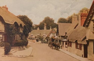
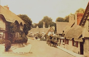 Kew Historical Society Inc
Postcard, Shanklin: The Village, c.1928
Collection of thirty-nine postcards donated by Jillian Rigby which had been owned by her grandparents, George and Edith Weir, who from c.1917 lived at 84 Princess Street, Kew. The mostly 'mint' postcards were purchased in Victoria and while travelling overseas. The sole dated postcard is dated from 1929. The postcards are numbered sequentially from 2017.0058.01-39. The remainder of the collection donated by Jill Rigby which was once owned by the Weirs of Broken Hill and Kew consist of costumes, costume accessories, photographs, and documents.The postcards in the Weir collection, especially those purchased on a trip or trips to the mother country, i.e. United Kingdom, represent a representative sample of sites that were considered significant to those Australians undertaking a reverse grand tour by member of the erstwhile colonies. Those postcards which are early views of Melbourne must have been produced commercially for some decades from the early part of the 20th century.Shanklin is a popular seaside resort and civil parish on the Isle of Wight, England , located on Sandown Bay. The postcard was probably purchased by George and Edith Weir on a trip to England and Scotland, circa 1928."Shanklin: The Village"postcards, george and edith weir, shanklin - isle of wight, postcards -- isle of wight, weir collection -
 St Patrick's Old Collegians Association (SPOCA)
Photograph - SPOCA, Tour of Ireland
-
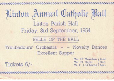 Linton and District Historical Society Inc
Ticket, Linton Annual Catholic Ball, 1954, 1954
White card with blue printing - Linton Annual Catholic Ball, Friday 3rd September 1954.Text: " Linton Annual Catholic Ball / Linton Parish Hall / Friday, 3rd September, 1954 / BELLE OF THE BALL / Troubadours' Orchestra - Novelty Dances / Excellent Supper. "linton catholic church, events, balls, mrs m. moynihan, mrs m. hayes, f. j. o'beirne -
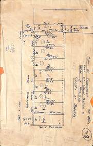 Ringwood and District Historical Society
Map, Subdivision Plan - 8 residential allotments south of City Road on Wantirna Road, Ringwood, Victoria - (Undated - circa 1950s)
Hand-drawn map on cardboard backing.Part of Crown Portion 11, Parish of Ringwood, County of Bourke. Some allotments include real estate sales notations. (North arrow incorrectly points east.) -
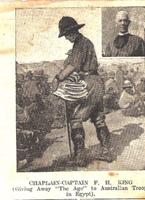 Waverley RSL Sub Branch
News paper Cutting Chaplain-Captain F. H. King, ? 1917
Captain Frank Herbert King was born in the Parish of St. Saviors in the borough of Brougham London March 5th 1875. He was educated in theology at St. Augustine's College Durban University. He went on to serve for 2 1/2 years in South Africa during the Boer Wars and then re-enlisted in the A.I.F.16th November 1916 when he listed his address as "The Vicarage Sunshine Victoria" and listed his wife as "Kathleen King" “Revd McCoy announced his intention of moving to the parish of Deniliquin in October 1915. He was replaced by F.H. King. Though the parish could not house him, he came in November. King was a typical “new broom”. In January 1916, at his instigation, the parish agreed to change its hymn book to Ancient and Modern. This decision could be viewed as a “churchmanship” matter, one of many that happened in these years. He pushed through the building of the vicarage, from tender in January to blessed and occupied by June. At the Annual General Meeting, King described 1915 as a trying time in the church and looked forward to a happier and more prosperous time during 1916. At a special vestry meeting, 3 November 1916, King announced that he had accepted an appointment by the Archbishop for service at the front, and that he had been instructed to prepare to go abroad. It was decided in his absence the parish use lay-readers, with periodic visits by clergy for Holy Communion. On 12 November, King thanked the parish for their loyalty and their devotion to him and the church. In return the parish presented him with a wrist watch. The parish was not formally vacant; just without a vicar. In September 1917, the Archbishop wrote advising that King had resigned. He appointed the Rev. W. Green to the parish, but Green declined.”(1) He was sent to Egypt where he administered to the Australian Stationary Hospital Australian 3rd and 5th light horse brigades. His Army record states he was Invalided and Completion of Duty 12 July 1918. He was later awarded th Order of the British Empire (OBE) 1 “The Junction” a history of St Mark’s Sunshine The picture of Chaplain-Captain F.H. King was carried in the Bible of Sig. H. C. Roussac ( a Gallipoli veteran) during his service with the A.I.F. in France. It can only be assumed that F.H.King had a profound effect on Sig. Roussac.Cutting of a lithographic picture showing Chaplain-Captain F. H. King giving away "The Age" (News paper) to Australian troops in Egypt 1917 Chaplain-Captain F. H. King giving away "The Age" to Australian troops in Egypta.i.f. egypt, chaplain, f.h.king, light horse egypt, roussac, o.b.e., boer war -
 Glen Eira Historical Society
Newsletter - St Peters Church of England, Murrumbeena
This file contains four items. THE PARISH MESSENGER St Agnes Glenhuntly and St Peters Murrumbeena – six newsletters dated from August 1912 to June 1914. St Peters Church Papers, Murrumbeena and Carnegie - two newsletters dated August 1915. St Peters Church Parish Paper, Murrumbeena and Carnegie – twenty newsletters dated from September 1917 to June 1925. St Peters Parish Paper, Murrumbeena, Carnegie and Hughesdale, nine newsletters dated from April 1926 to July 1934. All newsletters include information on Church activities, names of vicars and church officeholders.the parish messenger, st agnes glenhuntly, st peters murrumbeena, murrumbeena, phillips rev w. a., organs, glen huntly, rothschild st, addiscombe, house names, carnegie, neerim road, inghaim rev. a.e., churches, world war 1914-1918, emily street, green rev. walter, gleaners’ union, sowers (missionary band), carnegie methodist church, st peters church of england, green rev w.g.a., st peters vicarage, tennis clubs, baptisms, weddings, womens missionary unions, watts-ditchfield rev. j.e., mothers union, sunday school, ladies guild, baglin rev. j.t., hospitals’ league of mercy, nursing classes, thomas dr., faulkner e.h., advertisements, depression 1929-1939, business, fete, vestry, confirmation, bands, festivals, picnics, poynder rev. r., thos. grogan, drapery, awards, associations, church services, ingham rev. a.e., schools, cragg miss elvie, principals, choirs, st peters troop of boy scouts, hoggart miss, st peters school, st peters girls school, booth miss d., andrew miss eileen, meredith rev. charles w., church day school, walker miss, financial documents -
National Wool Museum
Book, An appraisal of a floor-price scheme for wool
"An appraisal of a floor-price scheme for wool" -Dr J H Duley and Dr R M Parish.wool sales wool marketing wool sales - floor price scheme, wool sales, wool marketing, wool sales - floor price scheme -
 Whitehorse Historical Society Inc.
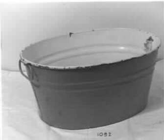
Functional object - Baby's Bath, c1880s
Used by Donor's mother's family. Grandfather Webber Parish Minister. Used by donor for her own familyTin baby bath painted yellow inside and green outside. Two bear decals insidedomestic items, ablutions -
 Ballarat Heritage Services
Photograph, Former Barkly Street Uniting Church, Ballarat, 2015
The church shut its doors on May 31, a date which marks the 162nd anniversary of the establishment of the parish.Church buildings associated with the former Barkly Street Uniting Church, Ballarat East. former barkly street uniting church, barkly street methodist church, ballarat east -
 Warrnambool and District Historical Society Inc.
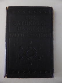
Book, The Cathedral Psalte, Early 20th century
This book has had two owners – St. Paul’s Anglican Church Allansford and Cecil Snook of Toorak but it is not known who had the book first. Nothing is known of Cecil Snook and the name does not appear to be of local interest. St. Paul’s Anglican Church in Allansford was established in 1882. It became part of the Panmure Parish in 1936 and in 1951 it was transferred to the Warrnambool Parish. This book is of interest as an example of a music book used at St. Paul’s Anglican Church in Allansford early in the 20th century. This is a hard cover book containing musical notations and text. The cover is black with embossed lettering and ornamental patterns on the front. The cover has come apart from the binding and has been re-attached with brown tape. The inscriptions are handwritten in black ink and pencil. There is some scribble on the back page. The cover is torn at the edges and the first and last pages are a little tattered. ‘St. Paul’s Allansford’ ‘All Saints Grammar School, East St. Kilda, Cecil Snook. 2 Baxter Street, Toorak, 11-6-1916’ history of warrnambool, st. paul’s anglican church allansford -
 Heathcote McIvor Historical Society
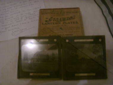
Glass Slides, Photographic, 1893
Belonged to Percy Webber who took the slides while he was parish priest of the church of england in Heathcote in 1893.these Glass slides are only known original pictures still in original box 9 in total taken in 1893 of the various views around heathcote.set of 9 Glass Plate Slides in original box. photographs of Heathcote McIvoron lid of box Gravura Lantern plates glass plate slides gravura, lantern -
Port Melbourne Historical & Preservation Society
Document - Invitation, Consecretion of Holy Trinity Anglican Church, Port Melbourne, Nov 2017
The new church has been consecrated within the original Parish Hall, after the church itself was sold for redevelopmentInvitation to attend the consecration of Holy Trinity Anglican Church of Port Melbourne by the Archbishop of Melbourne, Dr Philip Frier, Sunday 12 Nov 2017celebrations fetes and exhibitions, religion - anglican (holy trinity), rev noel whale, rev dr philip frier -
 Uniting Church Archives - Synod of Victoria
Photograph, Father Shimuye Mebratu with his silver Orthodox cross, 20/02/1985
Father Shimuye Mebratu is one of a growning number of Orthodox priests driven from their parish by drought in Wello Province.B & W waist length photograph of Father Shimuye Mebratu carrying a silver Orthodox cross."Father Shimuye Mebratu with his silver Orthodox cross Reproduction permission is granted for editorial purposes only. World Vision photo credit must be given at all times when reproducing this photo World Vision Media Department Phone (03) 699 8765 C&N 20/2/1985 page 7"mebratu, shimuye, father, orthodox cross -
 Whitehorse Historical Society Inc.
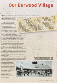
Article - The Bulletin newsletter, The Bulletin Jun - Aug 2022, Our Burwood Village, June 2022
An article about the first settlement surveyed in 1858 in the Burwood area known as Ballyshanassy. It later became Norwood and finally Burwood in 1879.An article about the first settlement surveyed in 1858 in the Burwood area known as Ballyshanassy. It later became Norwood and finally Burwood in 1879.An article about the first settlement surveyed in 1858 in the Burwood area known as Ballyshanassy. It later became Norwood and finally Burwood in 1879.ballyshanassy, albers ernest, boundary road burwood east, dempsey -
 Greensborough Historical Society
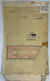
Poster - Planning Document, City of Heidelberg, Subdivision Plan # G 29 Part 2, Crown portion 16, Greensborough, 1951
Plan of Subdivisions in City of Heidelberg: Parish of Keelbundoora: Crown portion 16 - Daours Court and Devonshire Road, 1951.An example of hard copy subdivision plans from the Greensborough area. Mainly from the Shire of Diamond Valley era (1964-1994).Plan (single sided) mounted on heavy card. Stamped and handwritten Council permissions, dates and other details.subdivision plans, city of heidelberg