Showing 10393 items
matching plans
-
 Ringwood and District Historical Society
Pamphlet, Subdivisional Auction Sale, Bedford Park, Ringwood - 1924
Bedford Park subdivisional development did not eventuate. The land adjoining the railway line became parkland with provision for sporting facilities and the remainder was purchased by the Education Department as the site for Ringwood High School/Secondary College. Double sided bifolded auction sale advertisement including subdivision features and local facilitiesSubdivision plan includes Bedford Road, Graham Road, Joyce Street, Anderson Street, and Adams Street -
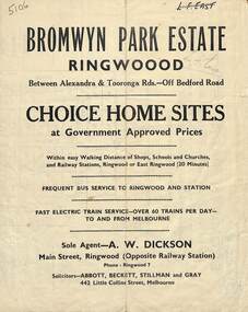 Ringwood and District Historical Society
Flyer, Bromwyn Park Estate, Ringwood - 1946 - Avertising Brochures and Map
Two pages of subdivision features, services and locationSubdivision plan includes Alexandra Road, Marwarra Street, Tooronga Road, Hilary Grove, Morcom Avenue. -
 Federation University Historical Collection
Map, Ballarat and Sebastapol Gold Mines, Late 19th Century
colored printed map on paper lined onto linen backingprinted "Rider & Mercer's Plan of the Ballarat & Sebastapol Gold Mines Scale 30 Chains to One Inch"gold mines, mine allotment map, mining leases, ballarat, sebastopol, rider and mercer, golden shaft co, prince of wales and bonshaw united, leviathan gold mines, holst and co, speedwell co, sebastopol plateau, rothschild co, tower hill co, south plateau, south star co, band of hop and albion consols, prince regent co, chenhall and co, despza, buninyong estate, one eye hully, winter's freehold, luplau plateau, e. morey, carrill's quartz -
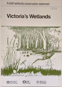 Wodonga & District Historical Society Inc
Book - Victoria's Wetlands, Dept. of Conservation, Forests & Lands, 1986
This publication was the result of an inquiry into the state of wetland environments in Victoria. It produced a draft strategy for conservation of threatened areas in the future.An 22 page book containing maps and illustrationsThis publication was the result of an inquiry into the state of wetland environments in Victoria. It produced a draft strategy for conservation of threatened areas in the future.wetland protection, wetlands victoria, water conservation -
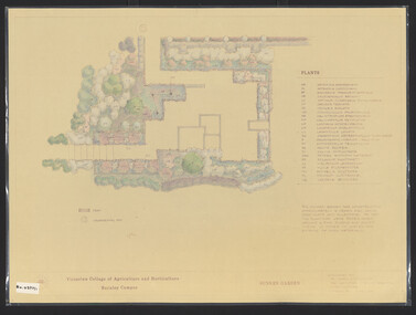 University of Melbourne, Burnley Campus Archives
Plan, James Hitchmough, Sunken Garden, 1981-1989
Most plans were held in Geoff Olives's office.(1) Sunken Garden. 1 tracing paper copy and 1 paper, laminated, coloured. Designed by Dr. James Hitchmough, drawn by Jill Kellow c1989. Plants supplied by Victorian Wholesale Nurseries Pty. Ltd. (2) The Sunken Garden. 1 tracing paper, partly coloured, 1 paper copy. Designed by James Hitchmough, drawn by Jill Kellow 20.12.1988. (3) Burnley Horticultural College Gardens Development Sunken Gardens: Plan Proposal I, March 1981 on tracing paper. (4) Burnley Horticultural College Gardens Development Formal Sunken Garden Proposal 2, March 1981 on tracing paper. (5) Burnley Horticultural College Sunken Garden Scheme II by G. Olive on tracing paper. Plants supplied by Victorian Wholesale Nurseries P.L. sunken garden, james hitchmough, jim kellow, andrew smith -
 University of Melbourne, Burnley Campus Archives
Plan, Methodist Ladies College, 1986-1988
(1) Site Plan showing Carparking by Hayball Sanderson & Partners Job No 86/142. Drawing No A1. Scale 1:55. November 1986. (2) Master Plan Courtyard Design by Richard Nosworthy, 8.11.88 Sheet No 2 (of 2) Elevation. (3) Master Plan MLC by Michael Doensen 8.11.88. Scale 1:100 Sheet No 1 of 2 Courtyard Planting Plan.hayball sandersons and partners, richard nosworthy, michael doensen, mlc, methodists ladies college -
 Bendigo Military Museum
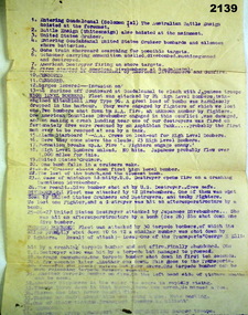
Administrative record - DOCUMENT, NAVAL, Est late 1942
... plans ...Item belonged to Arthur George Holley No 13556 RAN, HMAS Hobart. Refer 2134 for service history also 2137, 2147. Typed sheet in purple listing points 1-41 re brief description of the retaking of Gaudalcanal in 1942. There are 3 underlined headings, "High level bombers, Dive bombers, Torpedoe bombers". HMAS Hobart and Australia were involved. documents, naval, plans -
 Bendigo Military Museum
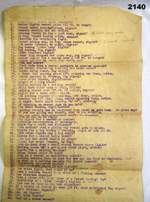
Accessory - DOCUMENT, NAVAL
... plans ...Item belonged to Arthur George Holley No 13556 RAN, HMAS Hobart. Refer 2134 for service history also 2135.3, 2137, 2147. Typed sheet in purple ink with points numbered from 1-66 re basically questions on Naval actions covering a range of subjects. naval, plans, documents -
 Federation University Historical Collection
Report, SMB: Budgetary Planning 1970/72; Buildings and other Capital Equipment Requirements, 1967/1968
... plans ...Report typed on A4 paper stapled together Includes two large map - folded to firballarat school of mines, plans, buildings -
University of Melbourne, Burnley Campus Archives
Plan - Photocopy of part of plan, Allen & Tuxen, 1888
... plans ...Horticultural Society of Victoria's Experimental Gardens, 1888allen & tuxen, plans, gardens -
 Whitehorse Historical Society Inc.
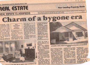
Article, Charm of a bygone era, 13/03/1991 12:00:00 AM
... plans ...Advertisement in Nunawading Gazette, 13 March 1991 for auction of 1920s houseAdvertisement in Nunawading Gazette, 13 March 1991 for auction of 1920s house at 449 Mitcham Road, Mitcham.Advertisement in Nunawading Gazette, 13 March 1991 for auction of 1920s houseauction maps, maps, plans -
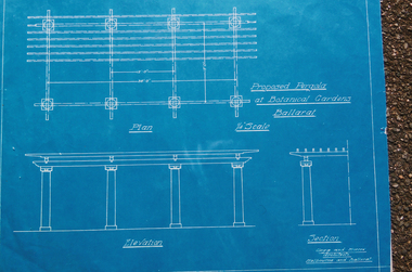 Friends of Ballarat Botanical Gardens History Group
Photograph - Digital image - jpg, Blueprint for pergola at the Ballarat Botanical Gardens
... Plans ...Photograph of blueprintballarat botanical gardens, plans, pergola -
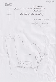 Whitehorse Historical Society Inc.
Plan, Portion 128 Parish of Nunawading, 13/03/1902
... Plans ...A4 Plan of part of Crown Portion 128 Parish of Nunawading dated 13/03/1902Photocopynon-fictionA4 Plan of part of Crown Portion 128 Parish of Nunawading dated 13/03/1902schwerkolt august, plans, parish of nunawading -
Port Melbourne Historical & Preservation Society
Plan, John James Wild, Architect, New Town Hall Sandridge 1881, 1 Jan 1881
Laminated copy from City collection, elevation plans for new Town Hall Sandridge 1881. .01 - front elevation .02 - rear elevation .03 - transverse section .04 - ground floor plan - A3 copy .05 - first floor plan - A3 copyarchitecture, port melbourne town hall, town clerks, built environment - civic, sandridge town hall, john james wild, edward clark -
University of Melbourne, Burnley Campus Archives
Work on paper (item) - Student Work, Lucas McGarrigle, Landscape Design Plan, 2018
Made as an assignment for HORT90035, a subject at Burnley Horticultural College coordinated by Andrew Laidlaw. assignment, landscaping, burnley horticultural college, landscape construction and graphics, hort90035 -
Glenelg Shire Council Cultural Collection
Plan - Plan - early Portland, n.d
Early plan drawing of PortlandHand-drawn plan on paper, glued on linen backing. Plan shows layout of properties and a lagoon. Hand-tinted in colour. Names of property owners written on lots.plan, map, town, portland -
Federation University Historical Collection
Report, Emma Nuttall, Goldfields Consultancy Proposal, 2002-5, 1995
.1) Strategic Plan for Goldfields Region: Consultancy Proposal .2) A Strategic Marketing Plan by four students of Tourism at the University of Ballarat relating to Victoria's Goldfields Region.victorian tourisim industry, tourism, goldfields, victorian goldfields -
Port Melbourne Historical & Preservation Society
Document - Specification, Metalling and chanelling, Rouse Street between Esplanade East and Esplanade West, Engineering Department, Town of Port Melbourne, 14 Mar 1893
Specification for tram and road works in Rouse Street between Esplanades East and West and adjacent to Lagoon Loan Works 1893 plan 19; relates to plan 99.2.Signed by JJ Bartlett (Mayor) 14.3.1893engineering - roads streets lanes and footpaths, sandridge lagoon, transport - tramways, arthur victor heath, town clerks, james john bartlett, mayors -
Port Melbourne Historical & Preservation Society
Plan - Tram and roadworks, Rouse Street between Esplanade East and Esplanade West, Engineering Department, Town of Port Melbourne, Mar 1893
Plan for tram and road works in Rouse Street between Esplanades East and West and adjacent to Lagoon Loan Works 1893 plan 19; relates to specification 99.1Signed by JJ Bartlett (Mayor) 14.3.1893engineering - roads streets lanes and footpaths, sandridge lagoon, transport - tramways, arthur victor heath, town clerks, james john bartlett, mayors -
Port Melbourne Historical & Preservation Society
Plan - Possible maritime shed, Borough of Sandridge, 1870s
An identified building plan - presumably a maritime shed (front elevation faces "the river") - proving front, traverse and longitudinal sections. Possibly two buildings. Plan No. 3.Charles Clay B.S. [Borough Surveyor]:W. Weatherston[e]built environment - civic, piers and wharves, charles clay, william weatherston[e] -
Port Melbourne Historical & Preservation Society
Document, Melbourne and Metropolitan Board of Works, 31 Oct 1935
Documentation of drainage works in 1935 for 141 Bridge St.Plan of drainage 31/10/1935. Details the Melbourne and Metropolitan Board of Works drainage plan for part of Port Melbourne. 141 Bridge St, Port MelbourneHand written details around blueprint of area. Notes made on right hand side and 3 signatures at the bottom.built environment - civic, built environment - domestic, engineering - board of works, melbourne and metropolitan board of works, mmbw, m h grover, r f bentley -
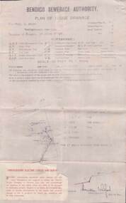 Bendigo Historical Society Inc.
Document - L. PROUT COLLECTION: PLAN OF HOUSE DRAINAGE
Bendigo Sewerage Authority, Plan of House Drainage. For Mrs. C. Prout, weatherboard property situated at 24 Quick Street. The plan is dated 30/10/1930.organization, public utility, water -
Bendigo Historical Society Inc.
Document - MARKS COLLECTION: ALTERATIONS TO FORTUNA VILLA FOR G. LANSELL
Copy of plan: Proposed alterations to Fortuna House (not Villa) for G. Lansell Esq. Plan shows stairway, building. Scale 1/4 inch - 1 foot.buildings, house, fortuna villa -
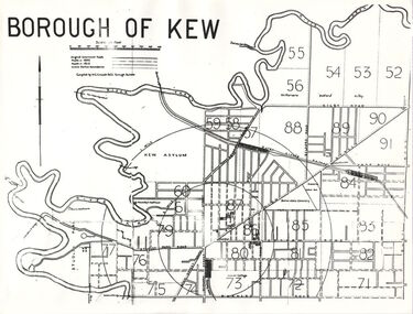 Kew Historical Society Inc
Plan, Borough of Kew, 1910
This work forms part of the collection assembled by the historian Dorothy Rogers, that was donated to the Kew Historical Society by her son John Rogers in 2015. The manuscripts, photographs, maps, and documents were sourced by her from both family and local collections or produced as references for her print publications. Many were directly used by Rogers in writing ‘Lovely Old Homes of Kew’ (1961) and 'A History of Kew' (1973), or the numerous articles on local history that she produced for suburban newspapers. Most of the photographs in the collection include detailed annotations in her hand. The overhead transparency is of a map produced by H.C. Crouch Borough Surveyor in 1910The Rogers Collection provides a comprehensive insight into the working habits of a historian in the 1960s and 1970s. Together it forms the largest privately-donated collection within the archives of the Kew Historical Society.An overhead transparency of a plan of Kew comparing the roads in 1860 with later roads constructed by 1910. Sections of the plan are marked with the location of particular buildings, farms or transport routes.Borough of Kewborough of kew, h.c. crouch -
University of Melbourne, Burnley Campus Archives
Plan, Glenferrie PR. S. No. 1508: Detail Survey, 1982
Original and 2 copies of Public Works Department, Victoria plans of Glenferrie Primary School for the Department of Education SU 2241.2. Shows site plan and Pit Schedule.glenferre primary school, survey -
University of Melbourne, Burnley Campus Archives
Plan, Alexander Metherell Pty. Ltd, Report on Existing Site Conditions at Victorian College of Agriculture and Horticulture Burnley, 1983
Report in plastic folder by Alexander Metherell Pty. Ltd., Melbourne dated November, 1983. Includes plans of Orchard and Campus. See B11.0716 and B11.0599 for descriptions of plans.alexander metherell, vcah, burnley -
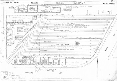 Melbourne Tram Museum
Drawing, Melbourne & Metropolitan Tramways Board (MMTB), "Kew Depot", c1938
Photocopied plans or drawings on A3 sheet of "Kew Depot 22/9/1938 P8400 - Plan of land and buildings - with some 1967 notes shows substation location.trams, tramways, drawings, depots, property, kew, substation -
Whitehorse Historical Society Inc.
Document, Eastern Freeway Extension, 2000 - 2002
Eastern Freeway ExtensionEastern Freeway Extension- Cost estimates for community consultation option Public consultation process : report on analysis submissions Deep Creek Road - Landscape concept Media Release from Premier of Victoria VicRoads - Works update newsletters Whitehorse City Council minutes VicRoads Correspondence Schwerkolt Cottage Precinct - Concept Plan VicRoads maps.Eastern Freeway Extensioneastern freeway extension, vicroads, victoria. department of infrastructure, city of whitehorse, schwerkolt cottage, landscape planning, maps -
Bendigo Historical Society Inc.
Plan - MARKS COLLECTION: ALBERT PARK SERPENTINE HOUSE PLAN FOR H. LANSELL
Laminated plan showing house plan, side and front elevations, for house plan for H. Lansell, Serpentine. Hand coloured drawings and floor plan. Edwardian style, shows large house with maid's quarters, cellar, dining room, bedrooms, dressing room. On top of plan written in black pen Proposed Homestead, Albert Park, Serpentine, for H. Lansell Esq, scale eight feet to one inch, W. Beebe & G.D. Garvin, architects, late W. Beebe, Mitchell Street, Bendigo...bendigo, house, albert park, serpentine -
 Warrnambool and District Historical Society Inc.
Ledger, Chadwick Copying Book Co, Letter book 1905, 1902
This letter book has maps, letters and plans dating from 1902 to 1905. It came from the office of John William Crawley, Junior, an engineer, architect and surveyor in private practice in Warrnambool and also the engineer for the Shire of Warrnambool from 1895 to 1935. His father, brother and son were all engineers and worked in that capacity or as Shire Secretary for the Shire of Warrnambool, with the Crawley family recording a total of 132 years of service to the Shire of Warrnambool. The Shire of Warrnambool existed from 1863 to 1994. This letter book was passed on to John Crawley’s son, Rolf, engineer for the Shire of Warrnambool from 1935 to 1968. The letter book then came into the possession of Michael Hand who took over the private surveying business of Rolf Crawley in Warrnambool. The Warrnambool and District Historical Society acquired the letter book, along with several other Crawley ledgers, from the Michael Hand estate. This letter book is of considerable importance as it contains the letters, maps and plans produced by John William Crawley Junior, a Shire of Warrnambool engineer for 40 years. It will be useful to researchers. This is a black hard cover letter book of 505 pages, plus an alphabetical index at the back of the book. The letter book contains handwritten letters, sketch maps and plans. There is gold lettering on the spine.‘1’ ‘Invoice’ ‘Chadwick Copying Book Co. Springfield Mass.’ john william crawley, junior, warrnambool, rolf crawley, warrnambool, shire of warrnambool, history of warrnambool