Showing 1438 items matching "allotment"
-
 Bendigo Historical Society Inc.
Document - H. A. & S. R. WILKINSON COLLECTION: CONTRACT OF SALE
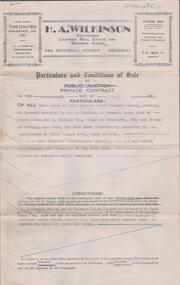
Conditions of sale by private contract dated 17th July, 1950 between H. Coombes (vendor) and W. & M. L. Seckold (purchaser). Property: land situate No. 57 station Street, Bendigo at present occupied by Mr. R. Boulden as tenant, being part of Crown allotment 8 section 71C, Parish of Sandhurst City of Bendigo, land described in certificate of title volume 6085 folio 1200514, together with 5 room weatherboard dwelling and all sundry outbuildings. Subject to existing weekly tenancy. Price: 600 pounds. Attached letter from solicitors Tatchell, Dunlop, Smalley & Balmer to Mr. Coombes and dated 3rd August, 1950 plus 2 hand written notes.organization, business, h.a. & s.r wilkinson real estate -
 Bendigo Historical Society Inc.
Document - H. A. & S. R. WILKINSON COLLECTION: CONTRACT OF SALE
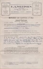
Conditions of sale by private contract dated 12th March, 1948 between C. J. Watt (vendor) and W. & M. L. Seckold (purchaser). Property: all that piece of land situate No. 28 Vine Street, Bendigo, at present occupied by D. Ellis as tenant, being part of Crown allotment 9 section 129C, Parish of Sandhurst City of Bendigo, being the land described in certificate of title volume 4685 folio 936900, together with 6 room weatherboard dwelling and all sundry outbuildings except any such outbuildings belonging to the tenant. Subject to existing tenancy. Price: 810 pounds. Attached 2 hand written notes plus a certificate of valuation giving a breakdown of the valuation.organization, business, h.a. & s.r wilkinson real estate -
 Bendigo Historical Society Inc.
Document - H. A. & S. R. WILKINSON COLLECTION: CONTRACT OF SALE
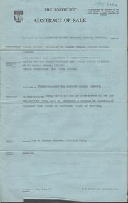
Contract of sale dated 23rd August, 1957 between Mr. E. M. Hope (vendor) and Mr. L. W. & Mrs G. E. Pearmain. Solicitor for vendor: Tatchell, Dunlop, Smalley & Balmer, Williamson Street Bendigo. Solicitor for purchaser: Tatchell, Dunlop, Smalley & Balmer, Williamson Street, Bendigo. Property: Lot 5 Lindsay Street, Kangaroo Flat being lot 5 on plan of subdivision in red ink no. A167046 part of allotment 4 section 23 township of Kangaroo Flat. Price 3,200 pounds. Attached Statement pursuant to section 34 of the estate agents act 1956 and Engagement or appointment in writing pursuant to section 33 of the estate agents act 1956.organization, business, h.a. & s.r wilkinson real estate -
 Bendigo Historical Society Inc.
Document - H. A. & S. R. WILKINSON COLLECTION: CONTRACT OF SALE
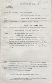
Contract of sale of land dated 4th October, 1955 between Mr. R. F. & Mrs. B. Wootton (vendor) and Mr. E. W. & Mrs. S. Peers (purchaser). Solicitor for vendor: Neal & Woodward. Solicitor for purchaser: Cohen, Kirby & Co. Property: land being part of Crown allotment 201 section K land described in certificate of title volume 7304 folio 627 and situate No. 33 Moran Street, Bendigo, having a frontage of 100.5 links y a depth of 170 links, together with 5 room weatherboard dwelling also all blinds electric stovette, all linos and curtains with the exception of the curtains in the front 2 rooms. Price: 2,600 poundsorganization, business, h.a. & s.r wilkinson real estate -
 Bendigo Historical Society Inc.
Document - H. A. & S. R. WILKINSON COLLECTION: CONTRACT OF SALE
Contract of sale of land dated 12th January, 1955n Mr. L. W. & Mrs. L. M. Dennis (vendor) and Mrs. A. M. Praetz (purchaser). Property: land delineated and coloured purple on the map in the margin being lot 11 on plan of subdivision 21180 lodged in the office of titles being part of Crown allotment 457 section H Parish of Sandhurst, City of Bendigo, land described in certificate of title volume 7793 folio 149 and situate 7 Margaret Crescent, Bendigo, together with 5 rooms weatherboard dwelling and all sundry buildings on said land, also all floor coverings, blinds and electric light fittings and shades. Price: 4,150 pounds.organization, business, h.a. & s.r wilkinson real estate -
 Bendigo Historical Society Inc.
Document - H. A. & S. R. WILKINSON COLLECTION: CONTRACT OF SALE
Contract of sale dated 19th September, 1957 between Mrs. M. D. Murray - Mrs. J. F. McDonald (vendors) and Mr. J. N. Taafe (purchaser). Solicitor for vendor: H. E. Every view Street, Bendigo. Solicitor for purchaser: Hogan & Hogan, Bull Street, Bendigo. Property: 240 Queen Street, Bendigo being part of Crown allotment 9 section 138C City of Bendigo, Parish of Sandhurst described in certificate of title volume 3041 folio 154 together with the dwelling house and all other erections thereon. Price: 1,175 pounds. Attached: statement pursuant to section 34 of the estate agents act 1956 and authority and conditions for public auction.organization, business, h.a. & s.r wilkinson real estate -
 Kew Historical Society Inc
Plan - Subdivision Plan, H C Crouch, Old Golf Links Estate, 1930s
The land in North Kew between the Outer Circle Railway and the River Yarra was released in sections. This release included 80 lots. Most of this area was released during the Depression years in the early 1930s.Subdivision plans are historically important documents used as evidence of the growth of suburbs in Australia. They frequently provide information about when the land was sold on which a built structure was subsequently constructed as well as evidence relating to surveyors and real estate and financial agents. The numerous subdivision plans in the Kew Historical Society's collection represent working documents, ranging from the initial sketches made in planning a subdivision to printed plans on which auctioneers or agents listed the prices for which individual lots were sold. In a number of cases, the reverse of a subdivision plan in the collection includes a photograph of a house that was also for sale by the agent. These photographs provide significant heritage information relating house design and decoration, fencing and household gardens.One part of a massive subdivision of the Old Golf Links Estate in North Kew of 80 allotments bordering Sutherland Avenue, Ramsay Avenue, Belford Road, Beresford Street and Coleman Avenue. Inset on the plan at the top left, the route of the Outer Circle Railway is clearly marked. The Kew Golf Links is identified in its current location. The land on which Greenacres Golf Club was to be constructed is at this time marked as ‘Recreation Ground’. The ‘new bridge’ over the Yarra at Burke Road is also marked on the inset map. The Plan identifies the surveyor (sic) H.C. Crouch BCE MVIS, 443 Little Collins St., Melbourne. The date of the subdivision auction sale in identified as Saturday September 25th at three o'clock.Annotations: "E" top left. "Golf Links" top right. Lots 73-76 ticked and listed as "6" poundssubdivisions -- kew (vic.), old golf links estate -
 Kew Historical Society Inc
Plan - Subdivision Plan, Kia Ora Estate, 1930s
Twenty-five grand allotments were offered for sale in the subdivision known as the Kia Ora Estate in Balwyn in the early 1930s. The streets identified in the subdivision include Whitehorse Road, Barnsbury Road, Campbell Road, Mont Albert Road and Burke Road. The lots were advertised for £10 deposit, with the balance to be paid over 5 years at 5 per cent per annum. The lots bordering Whitehorse Road were nominated as potential valuable shop sites, while the Mont Albert Road lots were advertised as having ‘wonderful views’. The Outer Circle Railway Line is shown traversing the subdivision. The route of the Railway in this area is now a walking/bike track bordered by strips of parkland.subdivision plans - balwyn, kia ora estate -
 Kew Historical Society Inc
Plan - Subdivision Plan, Myrtle Park Estate, City of Camberwell, 1916
The Kew Historical Society collection includes almost 100 subdivision plans pertaining to suburbs of the City of Melbourne. Most of these are of Kew, Kew East or Studley Park, although a smaller number are plans of Camberwell, Deepdene, Balwyn and Hawthorn. It is believed that the majority of the plans were gifted to the Society by persons connected with the real estate firm - J. R. Mathers and McMillan, 136 Cotham Road, Kew. The Plans in the collection are rarely in pristine form, being working plans on which the agent would write notes and record lots sold and the prices of these. The subdivision plans are historically significant examples of the growth of urban Melbourne from the beginning of the 20th Century up until the 1980s. A number of the plans are double-sided and often include a photograph on the reverse. A number of the latter are by noted photographers such as J.E. Barnes.The ‘Myrtle Park Estate’ was a subdivision bounded by Victoria Road (now Lansdowne Street), Buchanan Avenue and Dight Avenue. Other streets that were created by the subdivision included Eurolie Street, Boorahman Street and Moody Street (now Sylvan Street). The Estate took its name from Myrtle Park (later changed to Macleay Park), which had been created in 1923 by Camberwell Council. The Park adjoined the southeast corner of the new subdivision. The Estate included 74 regular allotments characterised by narrow frontages and long blocks. Confusion may have greeted prospective purchasers as the Estate was advertised in the daily newspapers as being in East Kew, rather than in Camberwell, where it was at that stage located.subdivision plans - balwyn, myrtle park estate - camberwell [surrey hills] -
 Kew Historical Society Inc
Plan - Subdivision Plan, Bella Vista Estate, 1929
Pru Sanderson, in her groundbreaking ‘City of Kew Urban Conservation Study : Volume 2 - Development History’ (1988), summarised the periods of urban development and subdivisions of land in Kew. The periods that she identified included 1845-1880, 1880-1893, 1893-1921, 1921-1933, 1933-1943, and Post-War Development. These periods were selected as they represented periods of rapid growth or decline in urban development. An obvious starting point for Sanderson’s groupings involved population growth and the associated economic cycles. These cycles also highlighted urban expansion onto land that was predominantly rural, although in other cases it represented the decline and breakup of large estates. A number of the plans in the Kew Historical Society’s collection can also be found in other collections, such as those of the State Library of Victoria and the Boroondara Library Service. A number are however unique to the collection.The Kew Historical Society collection includes almost 100 subdivision plans pertaining to suburbs of the City of Melbourne. Most of these are of Kew, Kew East or Studley Park, although a smaller number are plans of Camberwell, Deepdene, Balwyn and Hawthorn. It is believed that the majority of the plans were gifted to the Society by persons connected with the real estate firm - J. R. Mathers and McMillan, 136 Cotham Road, Kew. The Plans in the collection are rarely in pristine form, being working plans on which the agent would write notes and record lots sold and the prices of these. The subdivision plans are historically significant examples of the growth of urban Melbourne from the beginning of the 20th Century up until the 1980s. A number of the plans are double-sided and often include a photograph on the reverse. A number of the latter are by noted photographers such as J.E. Barnes.Bella Vista (later ‘Malinda’) was a large Federation house designed by the architect Robert Haddon for Abel Hoadley. The house was built in 1902 and occupied the eastern corner of Thomas Street and Cotham Road. It was a single-storey, red brick house, set back from the road, featuring a central tower topped by a pagoda-like red terra cotta roof, on top of which was perched a very large terra cotta dragon. The Bella Vista subdivision of 1929 included Hoadley’s house as well as nine allotments facing Cotham Road and Alfred and Thomas Streets. In 1941, the land on which Hoadley’s house stood was to be further subdivided. Bella Vista is believed to have lasted until it was demolished in the 1980s.subdivision plans - kew, bella vista estate -
 Bendigo Historical Society Inc.
Document - LANDS OFFICE: APPLICATION REGISTER, SECTION 29 GRAZING AREAS LAND ACT 1898
Document: hard cover indexed journal. On spine: red inset with 'Application Register' printed on gold, black inset with Section 29 Grazing Areas Land Act 1898' 'C' written in black ink. '35' and 1 - 1000' written above red inset. Journal has a loose slipcover of buff coloured linen-like material with cut-outs to allow information on spine to be viewed. Lh page: number of applications, date of registry, date of application, surname, Christian name and address, parish, allotment, section, area, local land board schedule. RH page: classification, lease, references and remarks. Details areas in central and northern Victoria. Dated from 22.12.1899 - 10.3.1906.land sales, victoria, lands office, bendigo, application register, applications for grazing land -
 Clunes Museum
Map - MAPS, A.C. BROOKS GOVERNMENT PRINTER MELBOURNE
.1 PARISH OF CLUNES, COUNTY OF TALBOT. (3 COPIES) (1) STAMP: DRAWING OFFICE RECORDS COPY, STATE ELECTRICITY COMMISSION OF VICTORIA. ELECTRICITY DEPARTMENT (THIS PLAN MUST NOT BE TAKEN FOR FIELD USE. PLEASE DO NOT DEFACE) C71 ON LEFT BOTTOM CORNER, CLUNES SHEET 1 (2) '19' HANDWRITTEN ON ALL FOUR CORNERS AND PLASTIC TAB FOR HANGING (3) PLASTIC TAB FOR HANGING .2 MAP BECKWORTH COUNTY OF TALBOT (3 COPIES) (1) IN RED: B-61. L.4855. THE ALLOTMENTS COLOURED BROWN ARE FREEHOLD (2) WITH PLASTIC TAB FOR HANGING (3) WITH PLASTIC TAB FOR HANGING. '14' HAND WRITTEN IN ALL 4 CORNERS AND VARIOUS PENCIL NOTATIONS ON THE MAP..1.2 DRAWN AND REPRODUCED AT THE DEPARTMENT OF LANDS & SURVEY MELBOURNE. PRICE 2/- .1 IN PENCIL ON BOTTOM ' 211 ' 20%parish of clunes, electricity supply department, beckworth -
 Bendigo Historical Society Inc.
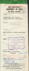
Document - H.A. & S.R. WILKINSON COLLECTION: CONTRACT OF SALE
This business was owned by father and son, Henry Archibald Wilkinson and Samuel Ronald "Ron" Wilkinson. Henry (1882-1954) was born in Shepparton and died in Bendigo. He was married to Grace Hovendon in 1908. Samuel Ronald "Ron" (1914-1995), Henry's son, was married to Florence Jean McKerlie in 1937.Contract of sale of real estate dated 21st July, 1965 between Sandhurst and Northern district Trustees Executors and Agency Company Limited of View Street, Bendigo as executors of the estate of Evelyn Julie Bidwell deceased (seller) and Mr. L.B. Smith & Mr. A. Heraud (buyers). Solicitor for vendor: Schleiger & Smalley, Bendigo. Solicitor for purchaser: E.S. Cahill & Son, View Street, Bendigo. Property at No.261 McCrae Street, Bendigo being part of Crown allotment 6 section 92C being land described in certificate of title volume 4507 folio 334, together with all floor coverings, blinds, curtains and electric light fittings and shades. Price 1,300 pounds.organization, business, h.a. & s.r wilkinson real estate -
 Bendigo Historical Society Inc.
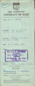
Document - H.A. & S.R. WILKINSON COLLECTION: CONTRACT OF SALE
This business was owned by father and son, Henry Archibald Wilkinson and Samuel Ronald "Ron" Wilkinson. Henry (1882-1954) was born in Shepparton and died in Bendigo. He was married to Grace Hovendon in 1908. Samuel Ronald "Ron" (1914-1995), Henry's son, was married to Florence Jean McKerlie in 1937.Contract of sale dated 15th April, 1959 between Mr. F. Kupke (seller) and Mr. P. 7 Mrs. F.E. Stevens (buyers). Solicitor for vendor: Hyett, Willis & Hyett, Bull Street, Bendigo. Solicitor for purchaser: E.S. Cahill & Son, View Street, Bendigo. Property in Sparrow Hawk Road, St. Just Point being allotments 65 and 66 section L containing 15 acres, 17 perches and being land described in Crown grant volume 7615 folio 125, together with all buildings and erections thereon, also stainless steel sink and cupboards. Also State Rivers and Water Supply Authority to irrigate for 3 acres. Price 1,000 pounds.organization, business, h.a. & s.r wilkinson real estate -
 Ringwood and District Historical Society
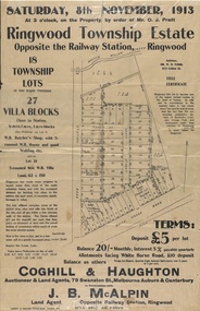
Flyer, Auction Sale Advertisements - Ringwood Township Estate, Ringwood, Victoria - 1913
Advertisements for auction sale of retail and residential blocks opposite the Ringwood Railway Station on Saturday, 8th November, 1913, showing subdivision layout, terms of sale, and summary of local features and services. Auction at 3 o'clock on the property by order of Mr. O.J. Pratt - 18 township lots, 27 villa blocks, also weatherboard butcher's shop with 5-roomed weatherboard house and good stabling, and 5-roomed new weatherboard villa. Subdivision includes Station Road (later Warrandyte Road), Pratt Street, and Whitehorse Road. Agents - Coghill & Haughton, 79 Swanston Street, Melbourne, Auburn & Canterbury, in conjunction with J.B. McAlpin, Opposite Railway Station, Ringwood. Additional 2 partially trimmed copies allotment maps on cardboard backing with handwritten sales notations. -
 Eltham District Historical Society Inc
Negative - Photograph, Popular Picnicing at Hurstbridge, c.1925
Picnickers enjoying a Sunday outing near the Wattle Valley Estate at Hurstbridge. Copied from brochure "Wattle Valley Estate". It is believed the picture is taken at the northwest corner of the intersection of Wattletree Road and Hurstbridge-Arthurs Creek Road looking southeast towards the township (most likely where the house is located on the property of what is today No. 2 Wattletree Road)- https://goo.gl/maps/VDorwCe1rJJUapjE6 According to a comment by Jean Verso (via @nillumbikcouncil FB page 3 Jan 2020) - "This view is from Wattle Tree Road with Haleys Gully Road to the right and across the creek to William Gray's nursery at Allwood. The building to the far left looks like Dorset House. The building on the left in the middle distance is still there today and has been used for storage and as a stable/tack room for a number of years." The Wattle Valley Estate was first advertised in August 1925 as weekend building allotments by the Greater Melbourne Land and Development Company. Advertised from £28.10.0 or £60 per block. In August 1926, 30 picked allotments of 60x150 feet were put up for auction Saturday August 14, 1926 with frontages to Valley View Road and Fawkner Crescent advertised in the “Heart of the Glorious Wattle Country” and “Within 15 Minutes of the Newly Electrified Railway Station”. The Advertiser on August 13, 1926 in an article promoting the auction stated “the estate is regarded as one of the best in the district, and will be sold practically without reserve.” It is noted that an advertisement running in The Argus February 22, 1951 offered the remaining 16 blocks for sale at £12.10.0 or £200 the lot. By March 7, the remaining blocks were advertised at £17.10.0 The Wattle Valley Estate took over 20 years to sell and then people could not build on them Cross Ref EDHS_02665 Rose Series Postcard P. 4341, "View at Hurstbridge, Vic." Also, other images from sales brochure SEPP_1055 / 1056This photo forms part of a collection of photographs gathered by the Shire of Eltham for their centenary project book,"Pioneers and Painters: 100 years of the Shire of Eltham" by Alan Marshall (1971). The collection of over 500 images is held in partnership between Eltham District Historical Society and Yarra Plenty Regional Library (Eltham Library) and is now formally known as the 'The Shire of Eltham Pioneers Photograph Collection.' It is significant in being the first community sourced collection representing the places and people of the Shire's first one hundred years.Digital image 4 x 5 inch B&W Neg1925, dorset house, fawkner crescent, haleys gully road, hurstbridge, hurstbridge-arthurs creek road, picnic, postcards, shire of eltham pioneers photograph collection, valley view road, wattle valley estate, wattletree road, exhibition yprl 2019-12 -
 Eltham District Historical Society Inc
Photograph - Postcard, Rose Stereograph Company, View at Hurstbridge, Vic, c.1925
Rose Series Postcard P. 4341 “View at Hurstbridge, Vic.” Picnickers enjoying a Sunday outing near the Wattle Valley Estate at Hurstbridge. Copied from brochure "Wattle Valley Estate". It is believed the picture is taken at the northwest corner of the intersection of Wattletree Road and Hurstbridge-Arthurs Creek Road looking southeast towards the township (most likely where the house is located on the property of what is today No. 2 Wattletree Road)- https://goo.gl/maps/VDorwCe1rJJUapjE6 According to a comment by Jean Verso (via @nillumbikcouncil FB page 3 Jan 2020) - "This view is from Wattle Tree Road with Haleys Gully Road to the right and across the creek to William Gray's nursery at Allwood. The building to the far left looks like Dorset House. The building on the left in the middle distance is still there today and has been used for storage and as a stable/tack room for a number of years." The Wattle Valley Estate was first advertised in August 1925 as weekend building allotments by the Greater Melbourne Land and Development Company. Advertised from £28.10.0 or £60 per block. In August 1926, 30 picked allotments of 60x150 feet were put up for auction Saturday August 14, 1926 with frontages to Valley View Road and Fawkner Crescent advertised in the “Heart of the Glorious Wattle Country” and “Within 15 Minutes of the Newly Electrified Railway Station”. The Advertiser on August 13, 1926 in an article promoting the auction stated “the estate is regarded as one of the best in the district, and will be sold practically without reserve.” It is noted that an advertisement running in The Argus February 22, 1951 offered the remaining 16 blocks for sale at £12.10.0 or £200 the lot. By March 7, the remaining blocks were advertised at £17.10.0 The Wattle Valley Estate took over 20 years to sell and then people could not build on them Cross Ref SEPP_1057, “Popular Picnicing at Hurstbridge” rcopied from Wattle Valley estate sales brochure.Digital file only Postcards scanned from the collection of Michael Aitken on loan to EDHS, 13 Feb 20181925, dorset house, exhibition yprl 2019-12, fawkner crescent, haleys gully road, hurstbridge, hurstbridge-arthurs creek road, michael aitken collection, picnic, postcards, rose stereograph company, shire of eltham pioneers photograph collection, valley view road, wattle valley estate, wattletree road -
 Bendigo Historical Society Inc.
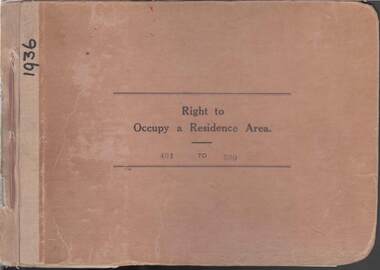
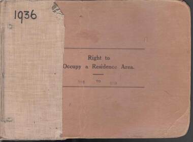
Book - RIGHT TO OCCUPY RESIDENCE AREA COLLECTION: REGISTER 1936
COLLECTION OF RIGHT TO OCCUPY A RESIDENCE AREA -LAND (RESIDENCE AREAS ) Act 1935 / thick cardboard book -cloth and string binding / written on front in texter '1936' / numbers 401 to 500 / inside - stubs of documents showing Granted to , of, period, Date of Right , Description of Land , Allotment, Section, City, Town, Borough, Township of, Parish of, Authorised Person . Rubber stamps show The interest of this Right has been transferred to / note on Bendigo Historical Society Catalogue Sheet dated 12.6.2008 All buts completed and original application forms removed. Note -forms were originally in triplicate on one page with serrations for removal of two parts; butts remain. Residence areas in Central Goldfields / form for butt 454 is included.Bendigo City Council - Acquisition 1990organization, government, bendigo land office, right to occupy a residence area -land (residence areas ) act 1935 -
 Bendigo Historical Society Inc.
Book - RIGHT TO OCCUPY RESIDENCE AREA COLLECTION: REGISTER 1936
COLLECTION OF RIGHT TO OCCUPY A RESIDENCE AREA -LAND (RESIDENCE AREAS ) Act 1935 / thick cardboard book -cloth and string binding / written on front in texter '1936' / numbers 301 to 400 / inside - stubs of documents showing Granted to , of, period, Date of Right , Description of Land , Allotment, Section, City, Town, Borough, Township of, Parish of, Authorised Person . Rubber stamps show The interest of this Right has been transferred to / note on Bendigo Historical Society Catalogue Sheet dated 12.6.2008 All buts completed and original application forms removed. Note -forms were originally in triplicate on one page with serrations for removal of two parts; butts remain .Residence areas in Central Goldfields / form for butt N0 331 is included.Bendigo City Council - Acquisition 1990organization, government, bendigo land office, right to occupy a residence area -land (residence areas ) act 1935 -
 Bendigo Historical Society Inc.
Document - H. A. & S. R. WILKINSON COLLECTION: CONTRACT OF SALE
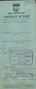
Contract of sale dated 22nd June, 1960 between Mr. I. M. Campbell (vendor) and Mr. F. F. & Mrs. R. B. Sharpe 9purchaser). Solicitor for vendor: Messrs. Watson, James & Rogers, Bull Street, Bendigo. Solicitor for purchaser: Messrs. Watson, James & Rogers, Bull Street, Bendigo. Property: 43 Hargreaves Street, Bendigo being part of Crown allotment 14A section 58C described in certificate of title volume 4443 folio 546 with right of carriageway over the land coloured brown on the map on the said title, together with all floor coverings, carpet square in dining room, hall carpet runner, inside and outside blinds, curtains and lamp shades as inspected. Price 2,700 pounds.organization, business, h.a. & s.r wilkinson real estate -
 Bendigo Historical Society Inc.
Document - H. A & S. R. WILKINSON COLLECTION: CONTRACT OF SALE
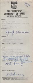
Contract of sale of real estate dated 16th April, 1966 between Mr. A. E. Ash C/- Home & Hospital for the Aged, Barnard Street, Bendigo (vendor) and Mr. D. P. & Mrs. J. Sherman (purchaser). Solicitor for vendor Mr. H. E. Every. Solicitor for purchaser: Mr. H. E. Every. Property 60 Carpenter Street, Bendigo being part of Crown allotment 34 & 35 section 104C land described in certificate of title volume 3820 folio 63811 having a frontage of 83. 3/10 links to Carpenter Street and a depth of 308 links through to Reginald Street together with blinds, curtains, floor coverings and light fittings. Price 7,000 dollarsorganization, business, h.a. & s.r wilkinson real estate -
 Bendigo Historical Society Inc.
Document - H. A. & S. R. WILKINSON COLLECTION: CONTRACT OF SALE
Contract of sale of land dated 7th October, 1965 between the executors of the will of John McDonald - Deceased (vendor) and Mr. J. B. & Mrs. E. M. Stringer (purchaser). Solicitor for vendor: Watson, James & Rogers, 61 Bull Street, Bendigo. Solicitor for purchaser: E. S. Cahill & Son, View Street, Bendigo. Property: Plumridge Street, White Hills being part of Crown allotment 7 and 8 section 12 at White Hills city of Bendigo land described in certificate of title volume 7120 folio 810, volume 7065 folio 960 and in conveyance registered number 776 book 607 together with all floor coverings, blinds, curtains and electric light fittings and shades. Price: 4,000 pounds.organization, business, h.a. & s.r wilkinson real estate -
 Bendigo Historical Society Inc.
Document - H. A. & S. R. WILKINSON COLLECTION: CONTRACT OF SALE
Contract of sale of land dated 11th January, 1956 between Mr. W. S. Bond (vendor) and Mr. R. B. Scott (purchaser). Property: surface and down to a depth of 50 feet below the surface of that piece of land being lot 71 on plan of subdivision lodged in the office of titles No. 16993 being part of Crown allotment 441B section H Parish of Sandhurst city of Bendigo and situate Corner Neale & Burrell Streets, Bendigo, together with brick dwelling, all sundry outbuildings, all floor coverings, all blinds, all electric light fittings and shades, Hoover washing machine, all curtains except those in the 2 front rooms and electric stovette. Price: 3,950 pounds.organization, business, h.a. & s.r wilkinson real estate -
 Bendigo Historical Society Inc.
Document - H. A. & S. R. WILKINSON COLLECTION: CONTRACT OF SALE
Contract of sale of land dated 25th August, 1956 between Mr. A. T. & Mrs. I. M. H. James (vendor) and Mr. J. H. Strange (purchaser). Property: lot 1 on plan of subdivision no. 19491 lodged in the office of titles being part of Crown allotment 24 Parish of Sandhurst County of Bendigo, land described in certificate of title volume 7646 folio 003 and situate Beischer Street, Bendigo, together with 5 roomed weatherboard dwelling, all sundry outbuildings, all floor coverings, blinds, curtains, Metro fridge, "Mettres" electric range, Hoover washing machine and all electric light fittings and shades. Price: 2,780 pounds. Attached 5 hand written notes .organization, business, h.a. & s.r wilkinson real estate -
 Bendigo Historical Society Inc.
Document - H. A. & S. R. WILKINSON COLLECTION: CONTRACT OF SALE
Contract of sale of land dated 20th May, 1954 between Mrs. B. S. Grant (vendor) and Mr. J. C. & Mrs. V. C. Tarr (purchaser). Solicitors for vendor: Noel & Woodward. Solicitor for purchaser: T. M. Williams, Watson & James. Property: that piece of land part of Crown allotment 12 section 19B Parish of Sandhurst City of Bendigo, land described in certificate of title volume 2734 folio 653 and situate No. 30 Shamrock street, Bendigo, together with 5 roomed weatherboard dwelling and all sundry outbuildings, also electric stovette, electric copper, all electric light fittings and shades, rotary clothes line, all blinds and linos. Price: 2,000 pounds.organization, business, h.a. & s.r wilkinson real estate -
Southern Sherbrooke Historical Society Inc.
Information Folder - Len Jeffery
Information folder containing items pertaining to Len Jeffery. Contents: -handwritten notes by Elaine Cordell, dated 2017 -letter, Peter & Ruth Jeffery, to Phil Garland, dated 25 June 2011 -letter, Peter & June Jeffery to Elaine Cordell, dated 26 July 2011 -photocopy, A4, of photo featuring Thomas & Henry Jeffery -photocopies of death notice and short obituary, undated -photocopies (2), parish map (part) -photocopy part of allotments in Parish of Narree Worran with attached newspaper clipping -photocopy of hand-drawn map of blocks in Belgrave Heights -magazine "Yarra Valley & Ranges country life", Issue 7 Winter 2011, featuring article about Peter Jeffery, Len Jeffery's nephewlennox jeffrey, peter jeffery, belgrave heights progress association -
 Bendigo Historical Society Inc.
Document - MCCOLL, RANKIN AND STANISTREET COLLECTION: NELL GWYNNE SYNCLINE
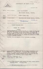
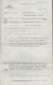
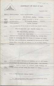
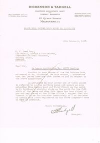
Manilla folder of documents relating to the Nell Gwynne Syncline Mining lease. Mentioned are Lease No.'s 10875 and 10903 which is in the Empire Road Stray Street area; R. Lethlean's Sluicing Claim; Albert Selisky has permissive Occupancy on ¼ acre; New Chum Syncline; Liddell's Chenical and Metallurgical Works; Arum Dredging Development NL. Application for a Hydraulic Sluicing Lease; Transfer of lease No. 10903, from H.J. Leed to North Nell Gwynne Gold Mines NL; Application form for the Nell Gwynne Syncline Co.. Application for leases 10945 and 10946; Nell Gwynne Syncline option to purchase lease 10945 for £1,000; Consent from Minna Matilda Lawson for inclusion of part of allotment 268 in lease No. 10875.Dickson & Tadgell Charted Accountants, 95 Queen Street, Melbourne C1gold, mining, land application, nell gwymme syncline, gold mines, bendigo -
 Kew Historical Society Inc
Plan - Subdivision : Cotham and Glenferrie Roads, J R Mathers & McMillan
The Kew Historical Society's map collection includes a substantial number of real estate subdivision plans, mainly of Kew but also of surrounding suburbs in Melbourne. Most of the subdivision plans date from the 1920s and 1930s when the districts old homes and local farmland were being split up to accommodate residential growth in the postwar period. These early plans were assembled by a local firm, Jas R Mather & McMillan, which had an office in Cotham Road. Many of the plans, and sometimes photos, were annotated by the agents.Subdivision plans are historically important documents used as evidence for the growth of suburbs in Australia. They frequently provide information about when the land was sold as well as evidence relating to surveyors and real estate and financial agents. The numerous subdivision plans in the Kew Historical Society's collection represent working documents, ranging from the initial sketches made in planning a subdivision to printed plans on which auctioneers or agents listed the prices for which individual lots were sold. In a number of cases, the reverse of a subdivision plan in the collection includes a photograph of a house that was also for sale by the agent. These photographs provide significant heritage information relating house design and decoration, fencing and household gardens.The photograph may also be aesthetically significant depending on the importance of the photographic atelier.An undated and untitled hand-drawn and coloured subdivision plan detailing the boundaries of a number of irregular allotments bordering Cotham Road, Glenferrie Road and Stirling Avenue (now Stirling Street). The plan predates the actual subdivision that led to the creation of the eight commercial properties occupying 118-132 Cotham Road. The plan may represent an old subdivision that was further subdivided at a later date, or it may be a subdivision that never eventuated. On MMBW Detail Plan 1575 (1903), the area represented by the proposed subdivision was residential rather than commercial. The irregularity of lots is also apparent in the MMBW Plan. The largest of the unnumbered blocks on the hand-drawn subdivision plan may relate to the boundaries of the nineteenth century mansion identified as ‘Kelso’ on the MMBW Plan.subdivision plans - kew, cotham road - kew,, glenferrie road - kew , stirling avenue street - kew -
 Kew Historical Society Inc
Plan, Sydney Arnold Best & Co, Field Place, Kew, c.1929
Pru Sanderson, in her groundbreaking ‘City of Kew Urban Conservation Study : Volume 2 - Development History’ (1988), summarised the periods of urban development and subdivisions of land in Kew. The periods that she identified included 1845-1880, 1880-1893, 1893-1921, 1921-1933, 1933-1943, and Post-War Development. These periods were selected as they represented periods of rapid growth or decline in urban development. An obvious starting point for Sanderson’s groupings involved population growth and the associated economic cycles. These cycles also highlighted urban expansion onto land that was predominantly rural, although in other cases it represented the decline and breakup of large estates. A number of the plans in the Kew Historical Society’s collection can also be found in other collections, such as those of the State Library of Victoria and the Boroondara Library Service. A number are however unique to the collection.The Kew Historical Society collection includes almost 100 subdivision plans pertaining to suburbs of the City of Melbourne. Most of these are of Kew, Kew East or Studley Park, although a smaller number are plans of Camberwell, Deepdene, Balwyn and Hawthorn. It is believed that the majority of the plans were gifted to the Society by persons connected with the real estate firm - J. R. Mathers and McMillan, 136 Cotham Road, Kew. The Plans in the collection are rarely in pristine form, being working plans on which the agent would write notes and record lots sold and the prices of these. The subdivision plans are historically significant examples of the growth of urban Melbourne from the beginning of the 20th Century up until the 1980s. A number of the plans are double-sided and often include a photograph on the reverse. A number of the latter are by noted photographers such as J.E. Barnes.An unnamed subdivision in Studley Park including five lots for sale in Studley Park Road, Highfield Grove and Tara Avenue. Unidentified on the plan, but clearly existing, are the Henty family mansion of Field Place and Tara Hall in Studley Park Road. The first attempted subdivision of Tara Hall was advertised in 1927 in which Lots 5, 6 and 7 in this plan were also advertised. Unusually, Lot 2 in Studley Park Road was created from the northern part of the Henty mansion, rather than Tara Hall. In the subdivision, lots were advertised at varying prices, with the highest price for land being Lot 2 in Studley Park Road. The plan notes that only one villa is to be allowed on each allotment.subdivision plans - kew, field place subdivision -- studley park – kew (vic.), highfield grove – kew (vic.), tara avenue – kew (vic.) -
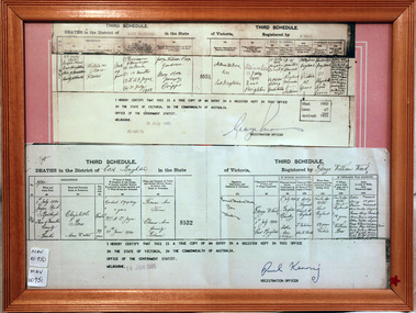 City of Moorabbin Historical Society (Operating the Box Cottage Museum)
Document, Death Certificate William Box 1902, 1985
William Box1834-1902 and Elizabeth Avis Box 1835-1913 came to Australia with his parents George and Mary Cripps-Box and siblings in 1856. Caroline Box, the eldest daughter of George and Mary Cripps-Box, remained in England working as a cook until she joined the family in Australia in 1863. William Box with his wife Elizabeth Avis Box at first leased market garden allotments in Brighton that was part of the Henry Dendy Special Survey 1841. In 1868 and 1869 they purchased 2 blocks with a pioneer’s cottage in Jasper Road East Brighton ( now Ormond / McKinnon ) where they established a market garden, built a 2nd house and raised 13 children. In 1908 Elizabeth sold most of the land retaining 1 acre with the dwellings in which she resided with her two daughters until her death 1913. The original pioneer cottage was reconstructed in 1984 and is known as Box Cottage Museum William & Elizabeth Avis- Box settled in the pioneer Cottage in Jasper Road East Brighton 1868 and established a market garden whilst raising their 13 children. This Cottage was reconstructed in Joyce Park, Ormond 1984 and is the home of City of Moorabbin Historical Society. In 1960 many local residents responded to a call for the donation of historical artefacts and the Box Cottage Museum now preserves this eclectic collection for the community. A certified true copy of the Death Certificate of William Box 1834 -1902 in a wooden picture frame, obtained from The Births, Deaths and Marriages Office Melbourne Victoria 1985 THIRD SCHEDULE / DEATHS in the District of East Brighton in the State of Victoria Registered by W. Ward Certified ‘true copy of an entry in a register’……… Signed by Paul Kenny Registration Officer 1985 box william, box elizabeth, brighton, moorabbin, cottages, pioneers, ormond, colonial, mckinnon, dendy henry, museums, box alonzo, market gardeners, box cottage museum