Showing 5786 items matching "location"
-
 Ringwood and District Historical Society
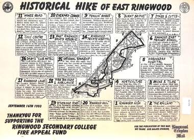
Document, Historical Hike of East Ringwood -1993
Black and white laminated mapMap includes 20 separate locations of historical interest around East Ringwood. Produced for the Ringwood Secondary College Fire Appeal Fund -September 16th 1993 -
 Whitehorse Historical Society Inc.
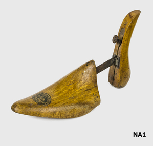
Tool - Shoe Tree
Exported to Australia. Fit male shoe size 8 approximately.Wood shoe shaped but with copper spring to collapse the heel to reduce storage space.Spring has copper handle with 'Cyclops Patent'. On toe area an oval gold and black stamp with manufacturing name and location. Centre picture St. George and Dragon?costume accessories, footwear accessories -
 Beechworth Honey Archive
Map- Beechworth
(3x) Map centred on Everton, Beechworth and Eldorado. Map shows Ovens River, Wangaratta- Beechworth Rd., Chiltern- Beechworth Rd., and Ovens Highway. Scale 1:50,000. Back of map white, front is yellow.Albury series R.652 (Beechworth) Two copies have towns shaded red. One copy has locations of dams marked. ca 1974-1975.map, beechworth, everton, eldorado, paper, beechworth honey -
 Melbourne Tram Museum
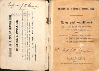
Book, Melbourne & Metropolitan Tramways Board (MMTB), "Melbourne and Metropolitan Tramways Board - Rules, Regulations", 1924
Book - dark grey Rexene covers, with title - "Melbourne and Metropolitan Tramways Board - Rules, Regulations". Two sections, stapled and bound within heavy card covers, 80 pages with a typed index pasted inside rear covers, printed by Sands & McDougall, Melbourne. Authorised by W. O. Strangward Secretary 1923 and printed 1924. On first page, has number "6246" stamped onto the page. Provides the Rules and Regulations of the Board concerning Accidents, fire, general instructions, signals, uniforms, staff working, special instructions to Motormen and Conductors, tickets, safety for both Cable and Electric tramways. By-Law No. 5 provided on pages 76 to 80. On page 80 has the Seal of the Board and those who signed the document - Alex Cameron Chairman, Thos. O'L Reynolds Member and W. O. Strangward Secretary. Inside rear cover is a 12 page typed index to the rules in broken into sections for each letter of the alphabet - pages for M to O missing. Extract re Staff and ticket rules added 19-12-16 - see image i7. 2nd copy added 18-01-2022 Images revised - scanned in two parts. Copy No. 18812nd copy has "Inspector J H Cowrie" written on the inside front cover, 1st page and inside rear cover. Stamped "Malvern" in two locationstrams, tramways, mmtb, melbourne, cable trams, rules, regulations, safeworking -
 Kiewa Valley Historical Society
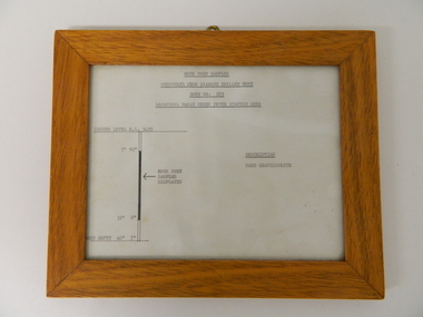
Sketch Rock Core Display, circa mid to late 1900's
This framed sketch details, in graphic form, where the core samples in the display cabinet were removed. The drilling was a precursor to the decision where to locate, in this case, the McKay Creek Power Station. The information gained by structural engineers from the core samples would be used also for the placements of underground tunnels entry and exit points and the overall effective size of the plant. This would have included drill and blast techniques(rock characteristics play an import part of explosion control), requirements for support structures and reinforcing cement/steel forms. The use and replenishment of diamond drill bits(the strongest available, see KVHS 0280) was dependent on the "type" of rock found. Support beams for reinforced ceilings and floors was also a necessity.The visual derails of where the rock core samples were removed is very significant in the formulation and placement of the underground Power Stations and their maze of tunnels(in and out) for a successful implementation of the Hydro Scheme. The amount of pre-planning and scientific studies required for such a large scheme must be undertaken to ensure that a "white elephant" was not the result.This framed and glass front rock core display sketch has type written information of the rock samples displayed in KVHS 0279 (A). It has a softwood stained and glossed frame with a fixed(nailed) back board and a brass fixture for mounting onto a wall.The paper and type are slighted faded (sunlight affected). The sign heading "ROCK CORE SAMPLES RECOVERED FROM DIAMOND DRILLED BORE" underneath this "BORE NO: 883" and below this "LOCATION: McKAY CREEK POWER STATION AREA" to the left a sketch incorporating the ground level point "GROUND LEVEL R.L.3493", and the core depth point "CORE DEPTH 40' 7". In between and representing( in visual form) the core location areain question.alternate energy supplies, alpine feasibility studies temperature, rainfall, sec, kiewa hydro scheme, electricity -
Ballarat Tramway Museum
Map, Ballarat Litho & Printing Co, "Electoral Map of Ballarat", 1920's?
Map showing the electoral boundaries of Ballarat - State? - possibly early 1920's. Has been marked up in blue pencil for electric and horse tram routes around Ballarat, along with names of terminals, depot, and other points of interest. Shows horse trams lines in Macarthur St and Armstrong St. Also has in pencil, approximate location of the railway to Buninyong. Map shows location of Showgrounds (old location), Hospital for epileptics, abattoirs, but does not show Ballarat North Railway Workshops. Title Block "Ballarat Litho & Ptg. Cos. / Electoral Map of / Ballarat / Scale 20 chains to One Inch" To be stored with minimal folding.trams, tramways, map, ballarat, horse trams -
 Halls Gap & Grampians Historical Society
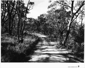
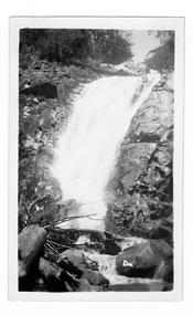
Photograph - B/W, C 1960s
Location unknown.The photo shows a sandy track through bushland.'Forests Commission, Victoria' inscribed on bottom, right of border. 'Publicity & Public relations Branch, When reproducing please Acknowledge Forests Commission, Victoria, Negative No. 322-14' stamped on back.access routes, roads, scenery, grampians ranges -
 Halls Gap & Grampians Historical Society
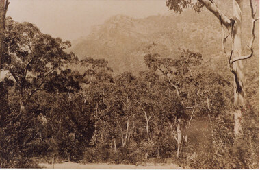
Photograph - Sepia
Location unknown.The photo is of a sandy track in the foreground with thick bush and mountain range in the background.scenery, grampians ranges -
 Stawell Historical Society Inc
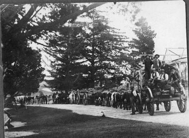
Photograph, Bullock Team Transporting Logs or Rocks Possibly Carrs Plains, c 1900
Location UncertainB/W Photograph of Two bullock teams in front of house, with large cypress trees or coniferstransportation -
 Ringwood and District Historical Society
Document, Collection of copies of Maps relating to Wieland Houses and Properties (most undated), plus Document entitle Brian Pump's Orchard and House Locations, 25/2/2008
Collection of A4 photocopies of maps and plans, some with yellow highlighting, showing locations of Wieland properties and house including sub-divisions. Mostly in Heathmont but also Scoresby Most pages are undated and do not have original sources Document 28054 entitled Brian Pump's Orchard and House Locations has notes with maps of various houses with numbers corresponding to those on the included maps and also to those in 28054-003 document -
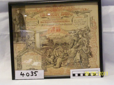 Rye RSL Sub Branch
Certificate of Service New Zealand Expeditionary Forces
An original Certificate of Service from the New Zealand Expeditionary Forces. Issued to 6/1511 Sergeant William Diamond, stating his service and locations and signed by the then Govenor General, 'Liverpool' -
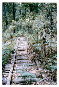 Marysville & District Historical Society
Photograph (item) - Colour photograph, 01-1964
A colour photograph of the timber tramway bridge along the Michaeldene Walking Track near Marysville in Victoria.A colour photograph of the timber tramway bridge along the Michaeldene Walking Track near Marysville in Victoria. The Michaeldene Trail to Taggerty River Lookout is a 4.3 kilometer lightly trafficked loop trail located near Marysville, Victoria. The track is one of several walking tracks located in and around Marysville in Victoria.MARYSVILLE JANUARY 1964timber tramway, michaeldene walking track, marysville, victoria, walking track -
Frankston RSL Sub Branch
Star Identifier, US Hydrographic Office, March 1942
Star identifier used in air navigation. It gives the positions of all stars included in both American and British Air AlmanacsRude star identifier with hydrographic office modifications, A-N type 1, with seven plastic transparent overlays, start and lunar location sheet, US Navy, circular, in vinyl coverRude star identifier with hydrographic office modifications, A-N type 1, Hydrographic Office No 2102-Crude star finder and identifier -
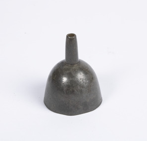 Mission to Seafarers Victoria
Functional object - Metal Funnel, c. 1840
Small Bell shaped metal funnel with a large primary container which then is connected to a secondary elongated cylindrical portion with a narrow opening. Found in the top container location of the parent item.volum collection -
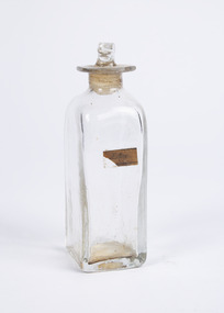 Mission to Seafarers Victoria
Container - Medicine Container, c. 1840
Small glass container with a square base and an octagonal rim surrounding the circular opening on the top. Paper label with the text: ‘AEther’. Found within the front storage location of the parent item.AEthervolum collection, medicine, chemist, apothecary, ether -
 Marysville & District Historical Society
Photograph (item) - Black and white photograph, December 1935
An early black and white photograph of Steavenson Falls in Marysville in Victoria.An early black and white photograph of Steavenson Falls in Marysville in Victoria. The Steavenson Falls is named after the Victorian Assistant Commissioner of Roads and Bridges, John Steavenson who arrived in Victoria in the early 1860's.Stevenson's Falls Dec. 1935 SUTHERLAND/ HEALESVILLEsteavenson falls, stevenson's falls, marysville, victoria, waterfalls, photograph, john steavenson -
Federation University Historical Collection
Booklet, Rewards to Discoverers of Gold fields, 1867, 1867
White Foolscap printed Government document relating discoverers of Victorian goldfields. It lists each discover, the location of their discovert, amount recommended, amount paid, date of payment, who paid. gold discoverers, gold discovery -
 Bendigo Historical Society Inc.
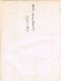
Document - CASTLEMAINE GAS COMPANY COLLECTION: MAINS LAYNG RECORDS, 1975-1977
Mains Laying Records 1975-1977. 34 pages of hand written records detailing dates, location, type of pipes, meters laid and costs over a two years period.business, retail, gas and fuel -
 Bendigo Historical Society Inc.
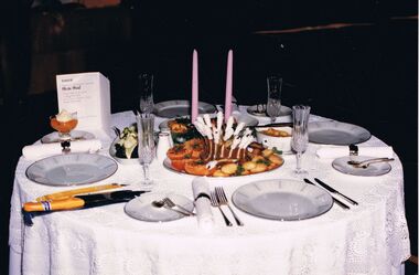
Photograph - CASTLEMAINE GAS COMPANY COLLECTION: PHOTO TABLE, 1987
1987 Cooking school's competition - Table set for 4, 3 plates of food in the middle, 2 candles and a menu. Location not described but possibly Catholic College Wodonga. . A7 on the back.Kodakevent, entertainment, school's cooking competition -
 Bendigo Historical Society Inc.
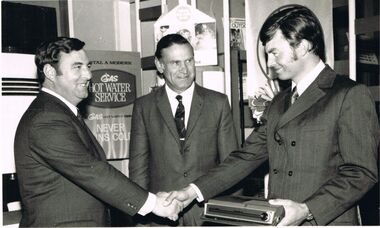
Photograph - CASTLEMAINE GAS COMPANY COLLECTION: PHOTO PEOPLE
Royce (cannot read surname) wins Sales Award - From left to right: Colin Knight , Hugh Ward (Bendigo Manager, Royce Bynon (Salesman). Date and location unknown.business, retail, gas and fuel -
 Bendigo Historical Society Inc.
Photograph - CASTLEMAINE GAS COMPANY COLLECTION: PHOTO MALE
Gas and Fuel Fashion,Food,Fitness. Male Standing in front of microphone, Curly hair, wearing grey cardigan and red beige horizontal strips shirt. Date and Location Unknown.event, social, gas & fuel fashion, food, fitness -
 Bendigo Historical Society Inc.
Photograph - CASTLEMAINE GAS COMPANY COLLECTION: PHOTO HOUSE
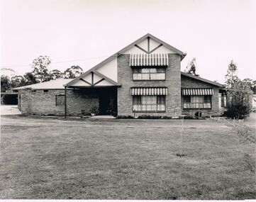
Date and Location Unknown - Photo of a Suburban House. On the Back Stamp of Aulsebrook & Martin Pty Ltd Photographers, 6 Ruth St. Golden Square 3555. phone 054 437565house, private, unknown -
 Bendigo Historical Society Inc.
Photograph - CASTLEMAINE GAS COMPANY COLLECTION: PHOTO PEOPLE
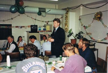
Nine people sitting around tables, one in a blue jacket with Billabong Australia on his back, standing at what looks like a workplace Christmas lunch. Date and location unknown.Kodakperson, group, gas and fuel christmas lunch -
 Bendigo Historical Society Inc.
Administrative record - Testimonials to Victorian individuals 1850s to 1900s
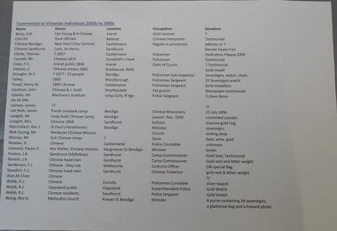
BHS CollectionOne page list of testimonials given to Victorian individuals from 1850s to 1900s. The list has the name of the recipient, the donor, the location where the individual worked, the occupation and the donation given.awards, 1850s-1900s -
 Bendigo Historical Society Inc.
Document - EAGLEHAWK HISTORICAL SOCIETY COLLECTION: EAGLEHAWK HERITAGE TRAIL
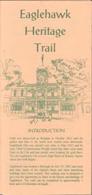
Small brochure titled: Eaglehawk Heritage trail, after an introduction a map of the points of interests, few drawing of different buildings, in total the brochure give small information on 33 locations.eaglehawk, history, walking tour -
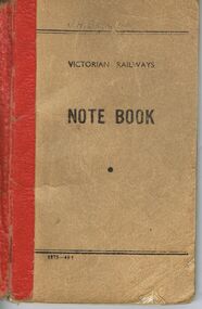 Bendigo Historical Society Inc.
Document - BADHAM COLLECTION: VICTORIAN RAILWAYS NOTE BOOK
Buff coloured note book, red spine. Victorian Railways Note Book printed on front cover. Contains diary type entries detailing, locations worked, items bought.J. Badhamcottage, miners, j. badham, railways -
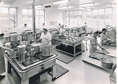 Bendigo Historical Society Inc.
Photograph - HANRO COLLECTION: KITCHEN
Black and white photograph of an industrial kitchen, There are nine women working at various locations. There are high windows visible on two sides of the kitchen. This is the kitchen associated with the dining room (entry 11000.139)organization, business, hanro, hanro, handschin and ronus, industrial kitchen, clothing manufacture -
Port Melbourne Historical & Preservation Society
Photograph - Centenary Bridge prior to complete demolition, Pat Grainger, 1988 - 1991
11 colour photographs taken from various locations of the Centenary Bridge prior to complete demolition in 1991 One B&W photo of the staircase on the West side of the Centenary Bridgecentenary bridge, demolitions, built environment, town planning - proposals shelved - bayside -
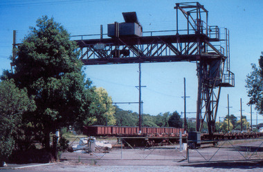 Port Melbourne Historical & Preservation Society
Photograph - Overhead crane in sidings on Evans Street, Port Melbourne, Glen Stuart, 1987
From set of nine colour photographs of various locations on the Port Melbourne Railway Line from Port Melbourne to Montague Stations, 1987: Overhead crane in the sidings on Evans Streettransport - railways, glen stuart -
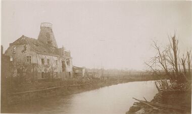 Bendigo Historical Society Inc.
Postcard - ACC LOCK COLLECTION: SEPIA PHOTO OF BOMBED BUILDING BESIDE A RIVER, POSTCARD, 1914-1918
Postcard, WW1, Sepia photo of bombed building beside a river. Other buildings in far distance. Defoliated trees on the right. Location unknown. Handwritten in pencil on the back - G43 and GSpostcard, postcard, ww1, france, ruins