Showing 10623 items
matching maps
-
 Bendigo Historical Society Inc.
Map - TARNAGULLA SHEET 3, No date Visible
Map: Tarnagulla Sheet 3, hand written on the side of the map. ( number 152 in Map Cupboard 1)map, parish plan, tarnagulla -
 Melbourne Tram Museum
Book, Brian Andrews, "By Birney to Golden Square", 1973
... Maps ...Book, 78 pages including card cover, printed on gloss paper, titled "By Birney to Golden Square", written by Brian Andrews, published by Southern Cross Traction, Kensington Park SA. Sub-titled "The last years of Bendigo's tramways", 1973. Features both black and white and colour photographs, including tickets, photos along each route, Charing Cross, depot, notes on the rolling stock with an aerial photograph of Bendigo with the tram routes marked in and a fold out detailed map of Bendigo and its track layout.trams, tramways, secv tramways, bendigo, maps -
 Woodend RSL
Map, Afghanistan South Western Oruzgan Helmad and Kandahar Province’s July 2009, September 2009
Map was used by Alan Mitchell-Lapin during patrols with Commando Regiment. Alan Mitchell-Lapin is a resident of Woodend.Alan Mitchell-Lappin is a member of the Woodend RSL who served with the Commandos in Afghanistan. Alan was awarded a Commendation for Gallantry for his service in Afghanistan. The map was utilised by Alan during his patrols.Patrol map for South Western Orguzgan Helmand and Kandahar Province’s. Scale 1:200,000. Produced by Australian Government Department of Defence Intelligence and Security. Table top right -Military Legend. Tables middle right - Language distribution, and translation glossary. Table bottom right hand corner - Topograhic Legend. Table centre bottom - Grid magnetic Diagrams. Table top left corner - Tarwin Kowt weather infromation.Produced by the Defence Imagery and Geospatial Organisation, Geospatial Analysis Centre, September 2009. Restricted at time of issue.afghanistan, map, orguzgan, helmand, kandahar, operation slipper, mitchell-lapin, 2009, digo 0098-0910, commando, special forces -
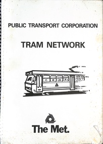 Melbourne Tram Museum
Book, Public Transport Corporation (PTC), "Tram Network", late 1980s
... Maps ...Titled "Metropolitan Tram Network" published by Public Transport Corporation with a drawing of an A class tram on the cover along with a The Met logo. Provides information in map form on each tram route in a large print format, contact numbers and some general information as a disability service. Gives details of Met customers services, office hours and Legend. See also item 1181 and 6000 for other examples. Possibly late 1980s as the Port Melbourne and St Kilda Light rail lines are detailed.Demonstrates the provision of information about Melbourne's tram routes at the time.Book - wire bound, 34 pages + card covers.tramways, ptc, the met, maps, disability services, tram routes, routes -
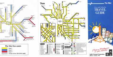 Melbourne Tram Museum
Pamphlet, The Met, "City and Suburbs Travel Guide", 1/01/1993
... Maps ...Pamphlet - 6 fold - titled "City and Suburbs Travel Guide", providing details on The Met ticketing zones, rail and tram maps, including the City Saver area. Extensive details on The Met ticketing system, effective 1/1/1993. .2 - ditto - 7 fold undated - based on fares 1994. 2 copies heldtrams, tramways, ptc, travel promotion, the met, maps, metcard -
 Peterborough History Group
Document - Establishment of Peterborough
Details progress of establishment of the district and the town Information about the town being Gazetted; Massacre Bay informationCopies of maps, pages of books and hand drawn mapbaradh clan, peterborough, peterborough history, buckley creek run, massacre bay -
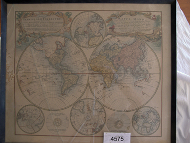 Flagstaff Hill Maritime Museum and Village
Map
Framed map of the known world in 1746. Map is in Frenchflagstaff hill, warrnambool, shipwrecked-coast, flagstaff-hill, flagstaff-hill-maritime-museum, maritime-museum, shipwreck-coast, flagstaff-hill-maritime-village -
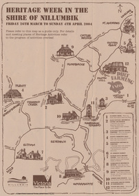 Eltham District Historical Society Inc
Booklet - Program, Shire of Nillumbik et al, Heritage Week in the Shire of Nillumbik, 2004
Map, with details of activitives presented by eight local history groups across the Shire of Nillumbik 26th March to Sunday 4th April 2004. Events included a dirt farming expo at Panton Hill. Program includes message by Mayor, Cr. Lex de Man and artwork by Syd Tunn. During the latter part of 2003 all of the historical societies and similar organisations in the Shire of Nillumbik attended a series of combined meetings arranged by Nillumbik Shire Council. The meetings were arranged by the Council's Arts and Cultural Services Co-ordinator and the Community Events Officer. ..The principal outcome of meetings ..to organise a Nillumbik Heritage Week to run from Friday 26th March to Sunday 4th April. The main event will be a combined heritage "expo" from 26th to 28th March, to be held in the Panton Hill Hall. The theme will be "Dirt Farming" which derives from the subsistence farming activities of the early settlers but could be widened to include gold mining, earth building and even modem day bushland regeneration. It fits well with the name "Nillumbik" which in the language of the Wurundjeri meant the not so good country covering most of our area and contrasted with the rich soil of the Kangaroo Grounds which they called Moor-rul. The following weekend each society will arrange their own separate activities. We intend to have open days at our Local History Centre on both days and this will include a display in the adjoining former Eltham Court House. We are also planning a heritage walk at 2.00pm on each day. Other groups will be having open days, displays, walks, guided car tours and other activities. - NL 154A3 sheet folded. Buff colour, with text and handrawn mapharry gilham collection, map, cultural heritage map, syd tunn, lex de man, eltham district historical society, nillumbik historical society, andrew ross museum, plenty historical society, st andrews queenstown historical society, warrandyte historical society, hurstbridge local history group -
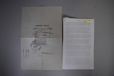 Warrnambool and District Historical Society Inc.
Map and Article, Dunmore, 1 1954 .2 1970
Both these items deal with the property of Dunmore, in the Macarthur/Hawkesdale/ Woolsthorpe area of Western Victoria. The first item is a sheet of paper with a map and details of the sale of portion of Dunmore in 1954. This is an original document. The second item is a history written by Stan Baulch of the property Dunmore from its establishment up to 1970. Dunmore was first established by Charles Hamilton MacKnight and two partners in 1842 and it was purchased by Samuel Baulch in 1893. After Samuel Baulch’s death the property was bequeathed to his three sons. One son, Stanley Baulch (1897-1980) took over the eastern portion which he named Rose Park. Stan Baulch was a member of the Warrnambool and District Historical Society and wrote several articles on aspects of his life and work, including this valuable article on the history of Dunmore. These items are of significance as they concern the estate of Dunmore in Western Victoria, an early and important property which is still farming land today under various owners. .1 This is a sheet of paper containing a map of the Dunmore property on one side and details of the sale of portion of Dunmore on the other side. The map has been annotated in handwritten black ink. The page has been folded twice. .2 This is an article typed on 12 foolscap pages. The typing is somewhat faint in places. ‘Dunmore’ Estate Dunmore baulch family, western district, victoria, dunmore estate, macarthur/hawkesdale, history of warrnambool -
 Orbost & District Historical Society
map/poster, Victorian Government Printer, 22.4.1926
The Department of Crown Lands and Survey was originally established in 1857 as part of the Board of Land and Works. In 1964 it ceased to be controlled by the Board. The Department functioned for almost twenty more years before being combined with other Ministries to form the Department of Conservation, Forests and Land. It was responsible for the management of the State's Crown land and pastoral estates. This map was used by Don Mehlert after 1928. The VERMIN AND NOXIOUS WEEDS ACT 1928 was an Act to consolidate the Law relating relating to Vermin and Noxious Weeds. E. J. E. G. Pemberton who published this poster was Superintendent of Field Staff, Dept. of Lands and Survey. This map and posters are significant records of early settlement history in Murrangower, between Cabbage Tree and Orbost,A paper map of Murrangower showing settlement subdivisions. This is glued onto the back of four overlapping cloth poster of "Notices of Vermin Destruction". All print is black."DON MEHLERT" in black pen. Pike's block shaded in blue. School site marked in blue pencil. on poster "MURRANGOWAR" along side.map-murrangower poster-vermin-and-noxious-weeds murrangower-settlement -
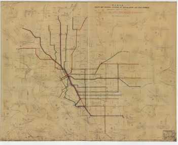 Melbourne Tram Museum
Drawing, Melbourne & Metropolitan Tramways Board (MMTB), "Route Map showing location of special work and pole numbers" "All night tram routes in colours", late 1941
Map of the system shown at two inches = 1 mile. Drawing No. P5799. Shows crossovers, track layouts at junctions, signal cabins roads, railways, and stations. Originally signed by Perway Engineer - 20/12/1940, though originally drawn in 1922. Has been marked up in colour pencil to show the all-night routes and the individual services. The plan shows the lines to Maribyrnong Munitions works along Cordite Ave and Wests Road and the track from Moonee Ponds to Union Road, opened in July 1941, but not the extension to Essendon Airport built in 1942.Demonstrates a detail drawing of Melbourne tramways, junctions and pole numbers.Drawings - dyeline cloth-backed print - titled - "Route Map showing the location of special work and pole numbers" and subtitled - "All night tram routes in colours". trams, tramways, mmtb, trackwork, tramways, junction, map, world war 2, night trams -
 City of Moorabbin Historical Society (Operating the Box Cottage Museum)
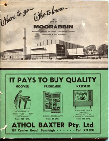
Magazine - Where to go .. Who to know .. in City of Moorabbin, Metropolitan Business Directories, Bentleigh, Ormond, McKinnon, Cheltenham, Highett, Moorabbin and East Bentleigh, 1962
... maps ...A booklet printed for the residents of the City of Moorabbin to acquaint them with the many amentities and services, as well as the employment opportunities, available close to their own homes. Booklet contains useful information about the City of Moorabbin, the services provided in the area, advertisements for local businesses, index of street names, Maps and more....Information booklet provided for the residents in the City of MoorabbinInformation booklet - 88 pagesbusiness, maps, city of moorabbin, bentleigh, ormond, mckinnon, cheltenham, highett, moorabbin, east bentleigh -
 Greensborough Historical Society
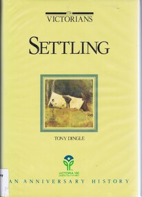
Book, Settling: The Victorians. By Tony Dingle, 1984_
Part 2 of a 3-part series deals with land use from Aboriginal land use to European settlement.Published to commemorate the 150th anniversary of European settlement in Victoria.Hard cover. 274 pages, illus., maps, end maps.victoria land use, victoria history, victoria social conditions, tony dingle -
 Lilydale RSL Sub Branch
map - WWII Australian map, C. G. Hartley & Co 1943, 1943
WWII Australian Issue Map Case/ Plotting Board - with map -
Glenelg Shire Council Cultural Collection
Booklet - Portland Brochure, 1970s
Portland brochure including advertising, town map and district map.portland, tourism, economy, advertising -
Bendigo Historical Society Inc.
Map - COUNTY OF GLADSTONE, November 1910
Map: County of Gladstone, Geological survey of Victoria. Geological mapmap, gladstone, geological, county of gladstone, geological map -
 Federation University Historical Collection
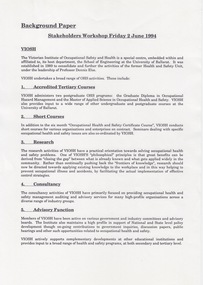
Document - Document - Information, VIOSH: Background Paper for Stakeholders Workshop, Friday 2 June 1994
Victorian Institute of Occupational Safety and Health (VIOSH) Australia is the Asia-Pacific centre for teaching and research in occupational health and safety (OHS) and is known as one of Australia's leaders on the field. VIOSH has a global reputation for its innovative approach within the field of OHS management. VIOSH had its first intake of students in 1979. At that time the Institution was known as the Ballarat College of Advanced Education. In 1990 it became known as Ballarat University College, then in 1994 as University of Ballarat. It was 2014 that it became Federation University. VIOSH Australia students are safety managers, senior advisors and experienced OHS professionals. They come from all over Australia and industry. Students are taught active research and enquiry; rather than textbook learning and a one-size fits all approach. VIOSH accepts people into the Graduate Diploma of Occupational Hazard Management who have no undergraduate degree - on the basis of extensive work experience and knowledge. The Background Paper prepared for a meeting to be held on Friday 2 May 1994. It is a Stakeholders Workshop. Information on VIOSH over the years provided. The range of OHS activities include: 1. Accredited Tertiary Courses 2. Short Courses 3. Research 4. Consultancy 5. Advisory Function 6. Information Resources The Graduate Diploma in OHM started in 1979 and was the first Occupational Health and Safety tertiary course in Australia. Since then it has continued to attract students at a national level even though similar courses were offered elsewhere. The map on Page 2 shows the extent of enrolments. The Courses Review Process is outlined and VIOSH is now able to define its own procedures and processes for reviewing its post-graduate programs.This is being managed by a small internal project management team. The "new" programs to commence in 1996.Four A4 pages, typed. Page 2 -map of Australiaviosh, victorian institute of occupational safety and health, ballarat college of advanced education, graduate diploma in ohm, stakeholders workshop, accredited tertiary courses, short courses, research, consultancy, advisory function, information resources, course review process -
Bendigo Historical Society Inc.
Map - HUNTLY, SHEET 4, 29/03/1876
Map: Parish of Huntly, Sheet 4, County of Bendigo. Hand Draughted Parish plan. Originally in Map Cupboard. Relocated to Map Drawer 5 on 22.9.22. Too long for the map cupboard.map, bendigo, parish plan, huntly -
 Warrnambool and District Historical Society Inc.
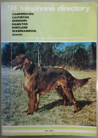
Book, Telephone Diretory 1974, 1974
The directory contains both White Pages and Pink Pages listings. The White Pages listings are in alphabetical order of names for the entire district. This is a soft cover booklet with a green cover and a colour photograph of an Irish Setter on the front cover and a map of the telephone area on the back cover. Front cover – ’74 Telephone Directory, Camperdown, Casterton, Edenhope, Hamilton, Portland, Warrnambool districts. STD area code 055. See back cover for area covered by this directory Spine – Camperdown, Casterton, Edenhope, Hamilton, Portland, Warrnambool districts. See the pink pages for business & trade listings. V1- 1974 Back Cover – Country directory areas. The area covered by this Directory is the coloured portion of this map. See the pink pages for business and trade listings. warrnambool 1974, warrnambool telephone directory 1974 -
Bendigo Historical Society Inc.
Map - BENDIGO SHEET 3
Map: copy of Parish plan, canvas backed. Map shows Bendigo city streets. ( number 126 in Map Cupboard 1)map, bendigo, city streets, bendigo, city streets -
Creswick Campus Historical Collection - University of Melbourne
Map, 1923
Includes detail of Plantation layout and plantings at the time and later plantings (1930's) in pencil.Map -
 Creswick Campus Historical Collection - University of Melbourne
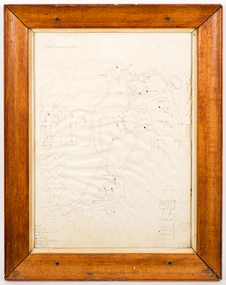
Map - Campus map, framed, 1969-1974
VSF Fire protection Plan. Framed. Prepared in interval between construction of Science Block and commencement of Certificate Courses (1969-1974) (Bob Orr)Mapfire protection, victorian school of forestry, creswick -
 Magnet Galleries Melbourne Inc
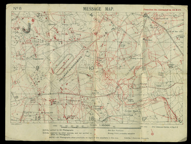
map showing trenches &c, red cliffs00168.tif
mapww1, world war 1, map, trenches -
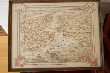 Magnet Galleries Melbourne Inc
map of gallipoli / turkey, redcliffs_dsf6241.tif
mapww1, world war 1, gallipoli, turkey, map -
 Victorian Aboriginal Corporation for Languages
Book, Leanne Hinton, The green book of Language revitalization in practice, 2008
1. Language Revitalization: An Overview /? Leanne Hinton 2. Diversity in Local Language Maintenance and Restoration: A Reason For Optimism /? Anna Ash, Jessie Little Doe Fermino and Ken Hale 3. Federal Language Policy and Indigenous Languages in the United States /? Leanne Hinton 4. "... To Help Assure the Survival and Continuing Vitality of Native American Languages" /? Robert D. Arnold 5. Language Planning /? Leanne Hinton Introduction to the Pueblo Languages /? Leanne Hinton 6. Native Language Planning: A Pilot Process in the Acoma Pueblo Community /? Christine P. Sims 7. The Key To Cultural Survival: Language Planning and Revitalization in the Pueblo de Cochiti /? Regis Pecos and Rebecca Blum-Martinez The Navajo Language: I /? Ken Hale 8. Navajo Head Start Language Study /? Paul R. Platero 9. Introduction to Revitalization of National Indigenous Languages /? Leanne Hinton Introduction to the Welsh Language /? Leanne Hinton 10. Welsh: A European Case of Language Maintenance /? Gerald Morgan Introduction to the Maori Language /? Ken Hale 11. Te Kohanga Reo: Maori Language Revitalization /? Jeanette King An Introduction to the Hawaiian Language /? Leanne Hinton 12. The Movement to Revitalize Hawaiian Language and Culture /? Sam L. No'Eau Warner 13. "Mai Loko Mai O Ka 'I'ini: Proceeding from a Dream": The 'Aha Punana Leo Connection in Hawaiian Language Revitalization /? William H. Wilson and Kauanoe Kamana 14. Teaching Methods /? Leanne Hinton The Karuk Language /? Leanne Hinton 15. Teaching Well, Learning Quickly: Communication-Based Language Instruction /? Terry Supahan and Sarah E. Supahan The Navajo Language: II /? Ken Hale 16. Tsehootsooidi Olta'gi Dine Bizaad Bihoo'aah: A Navajo Immersion Program at Fort Defiance, Arizona /? Marie Arviso and Wayne Holm 17. The Master-Apprentice Language Learning Program /? Leanne Hinton 18. Linguistic Aspects of Language Teaching and Learning in Immersion Contexts /? Ken Hale 19. New Writing Systems /? Leanne Hinton An Introduction to Paiute /? Leanne Hinton and Ken Hale 20. Language Revitalization in the San Juan Paiute Community and the Role of a Paiute Constitution /? Pamela Bunte and Robert Franklin 21. Audio-Video Documentation /? Leanne Hinton Australian Languages /? Ken Hale 22. Strict Locality in Local Language Media: An Australian Example /? Ken Hale The Arapaho Language /? Ken Hale 23. Reflections on the Arapaho Language Project, or When Bambi Spoke Arapaho and Other Tales of Arapaho Language Revitalization Efforts /? Stephen Greymorning Irish /? Ken Hale 24. Continuity and Vitality: Expanding Domains through Irish-Language Radio /? Colleen Cotter The Mono Language /? Ken Hale 25. On Using Multimedia in Language Renewal: Observations from Making the CD-ROM Taitaduhaan /? Paul V. Kroskrity and Jennifer F. Reynolds 26. Can the Web Help Save My Language? /? Laura Buszard-Welcher 27. Training People to Teach Their Language /? Leanne Hinton Inuttut and Innu-aimun /? Ken Hale 28. The Role of the University in the Training of Native Language Teachers: Labrador /? Alana Johns and Irene Mazurkewich Languages of Arizona, Southern California, and Oklahoma /? Leanne Hinton 29. Indigenous Educators as Change Agents: Case Studies of Two Language Institutes /? Teresa L. McCarty, Lucille J. Watahomigie and Akira Y. Yamamoto /? [et al.] The Navajo Language: III /? Ken Hale 30. Promoting Advanced Navajo Language Scholarship /? Clay Slate 31. Sleeping Languages: Can They Be Awakened? /? Leanne Hinton 32. The Use of Linguistic Archives in Language Revitalization: The Native California Language Restoration Workshop /? Leanne Hinton The Ohlone Languages /? Leanne Hinton 33. New Life for a Lost Language /? Linda Yamane.Maps, b&w photographs, tables, word listslanguage policy, language planning, language maintenance, language revitalization, language immersion, language literacy, media and technology, language education and training, sleeping languages, navajo, arapaho -
 Victorian Aboriginal Corporation for Languages
Book, Brett Baker, Indigenous language and social identity : papers in honour of Michael Walsh, 2010
For almost 40 years, Michael Walsh has been working alongside Indigenous people: documenting language, music and other traditional knowledge, acting on behalf of claimants to land in the Northern Territory, and making crucial contributions to the revitalisation of Aboriginal languages in NSW. This volume, with contributions from his colleagues and students, celebrates his abiding interest in and commitment to Indigenous society with papers in two broad themes. ?Language, identity and country? addresses the often complex relations between Aboriginal social groups and countries, and linguistic identity. In ?Language, identity and social action? authors discuss the role that language plays in maintaining social identities in the realms of conversation, story-telling, music, language games, and in education. ?Language and Social Identity in Australian Indigenous Communities? will be of interest to students of linguistics, Indigenous studies, anthropology, and sociology. Contents: 1. Introduction /? Rod Gardner ... [et al.] 2. Michael Walsh : a personal reflection /? Ros Fraser 3. Place and property at Yintjingga/?Port Stewart under Aboriginal Law and Queensland Law /? Bruce Rigsby and Diane Hafner 4. Linguistic identities in the eastern Western Desert : the Tindale evidence /? Peter Sutton Juwaliny : dialectal variation and ethnolinguistic identity in the Great Sandy Desert /? Sally Dixon 6. Who were the 'Yukul'? and who are they now? /? Brett Baker 7. Colonisation and Aboriginal concepts of land tenure in the Darwin region /? Mark Harvey 8. Aboriginal languages and social groups in the Canberra region : interpreting the historical documentation /? Harold Koch 9. The Kuringgai puzzle : languages and dialects on the NSW Mid Coast /? Jim Wafer and Amanda Lissarrague 10. Dawes' Law generalised : cluster simplification in the coastal dialect of the Sydney language /? David Nash 11. Space, time and environment in Kala Lagaw Ya /? Lesley Stirling 12. Turn management in Garrwa mixed-language conversations /? Ilana Mushin and Rod Gardner 13. Laughter is the best medicine : roles for prosody in a Murriny Patha conversational narrative /? Joe Blythe 14. Collaborative narration and cross-speaker repetition in Umpila and Kuuku Ya'u /? Clair Hill 15. Co-narration of a Koko-Bera story : giants in Cape York Peninsula /? Paul BlackMaps, b&w photographs, charts, word listslanguage and identity, language maintenance, language and culture, language and country -
 Victorian Aboriginal Corporation for Languages
Book, Harold Koch, Aboriginal placenames : naming and re-naming the Australian landscape, 2009
"Aboriginal approaches to the naming of places across Australia differ radically from the official introduced Anglo-Australian system. However, many of these earlier names have been incorporated into contemporary nomenclature, with considerable reinterpretations of their function and form. Recently, state jurisdictions have encouraged the adoption of a greater number of Indigenous names, sometimes alongside the accepted Anglo-Australian terms, around Sydney Harbour, for example. In some cases, the use of an introduced name, such as Gove, has been contested by local Indigenous people." "The 19 studies brought together in this book present an overview of current issues involving Indigenous placenames across the whole of Australia, drawing on the disciplines of geography, linguistics, history, and anthropology. They include meticulous studies of historical records, and perspectives stemming from contemporary Indigenous communities. The book includes a wealth of documentary information on some 400 specific placenames, including those of Sydney Harbour, the Blue Mountains, Canberra, western Victoria, the Lake Eyre district, the Victoria River District, and southwestern Cape York Peninsula." -- Publisher description. Contents: Introduction: Old and new aspects of Indigenous place-naming /? Harold Koch and Luise Hercus NSW &? ACT: 1. Aboriginal placenames around Port Jackson and Botany Bay, New South Wales, Australia: sources and uncertainties /? Val Attenbrow 2. Reinstating Aboriginal placenames around Port Jackson and Botany Bay /? Jakelin Troy and Michael Walsh 3. The recognition of Aboriginal placenames in New South Wales /? Greg Windsor 4. New insights into Gundungurra place naming /? Jim Smith 5. The methodology of reconstructing Indigenous placenames: Australian Capital Territory and south-eastern New South Wales /? Harold Koch Victoria: 6. Toponymic books and the representation of Indigenous identities /? Laura Kostanski 7. Reviving old Indigenous names for new purposes /? Laura Kostanski and Ian D. Clark 8. Reconstruction of Aboriginal microtoponymy in western and central Victoria: case studies from Tower Hill, the Hopkins River, and Lake Boga /? Ian Clark South Australia &? Central Australia: 'Aboriginal names of places in southern South Australia': placenames in the Norman B.Tindale collection of papers /? Paul Monaghan 10. Why Mulligan is not just another Irish name: Lake Callabonna, South Australia /? J.C. McEntee 11. Murkarra, a landscape nearly forgotten: the Arabana country of the noxious insects, north and northwest of Lake Eyre /? Luise Hercus 12. Some area names in the far north-east of South Australia /? Luise Hercus 13. Placenames of central Australia: European records and recent experience /? Richard Kimber Northern Australia: 14. Naming Bardi places /? Claire Bowern 15. Dog-people: the meaning of a north Kimberley story /? Mark Clendon 16. 'Where the spear sticks up': the variety of locatives in placenames in the Victoria River District, Northern Territory /? Patrick McConvell 17. 'This place already has a name' /? Melanie Wilkinson, Dr R. Marika and Nancy M. Williams 18. Manankurra: what's in a name? placenames and emotional geographies /? John J. Bradley and Amanda Kearney 19. Kurtjar placenames /? Paul Black.Maps, b&w photographs, tables, word listsaustralian placenames, sociolinguistics, linguistics, anthropology, sydney harbour placenames, blue mountains placenames, canberra placenames, western victoria placenames, lake eyre placenames, victoria river district placenames, cape york peninsula placenames -
 Victorian Aboriginal Corporation for Languages
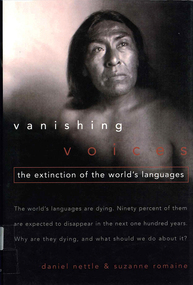
Book, Daniel Nettle et al, Vanishing voices : the extinction of the world's languages, 2000
Looking at vanishing languages from around the world and what can be done to prevent it.B&w illustrations, b&w photographs, mapslinguistics, endangered languages -
 Victorian Aboriginal Corporation for Languages
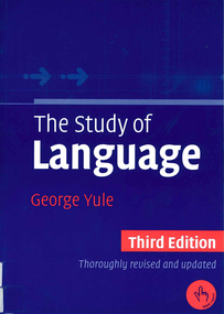
Book, George Yule, The study of Language, 2006
Issues in language study: origin of language, animals & human language, writing, phonetics, phonology, words & word-formation processes, morphology, grammar, syntax, semantics, pragmatics, discourse analysis, language and the brain, language acquisition, gestures and sign languages, languages and regional variation, language and social variation, language and culture.B&w illustrations, b&w photographs, mapslinguistics, sociolinguistics, history and language -
 Victorian Aboriginal Corporation for Languages
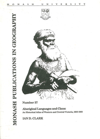
Book, Ian D Clark, Aboriginal languages and clans : an historical atlas of Western and Central Victoria, 1800-1900, 1990
Comprehensive coverage of language in the Western and Central Victorian areas, 1800-1900. Includes detailed language structures and historical details, Aboriginal Protectors and their work are included.maps, b&w illustrations, b&w photographsaboriginal clans, spatial and social organization, dhauwurd wurrung, gundijimara, djab wurrung, dja dja wurrung, djargurd wurrung, gadubanud, girai wurrung, gulidjan, jardwadjali, wada wurrung, wergaia