Showing 176718 items
matching nellie-street
-
 Rutherglen Historical Society
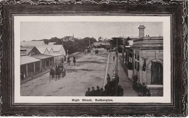
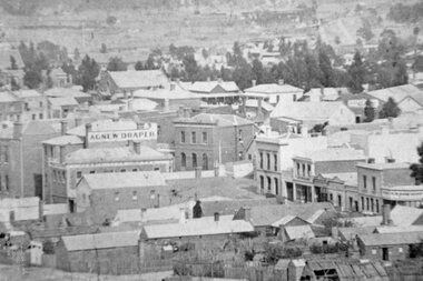
Image, High Street, Rutherglen, 1910 to 1912
Black and white photograph on a post card, with brown border, showing High Street, Rutherglen facing south from Main Street.high street -
 Eltham District Historical Society Inc
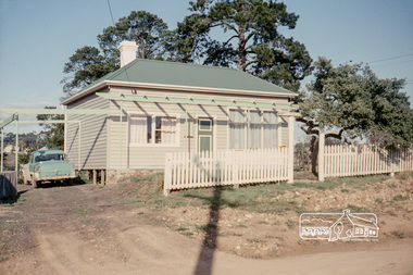
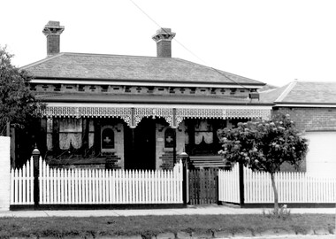
Photograph, Russell Yeoman, 66 Susan Street, Eltham, 1965c
Farmhouse built in the late 1800s by the Crozier Family. Subsequently owned by the Hill Family. Purchased in the early 1960s and by 1965 the property was owned by the Shire of Eltham. Employees of the Shire lived in the house. In 2006 the Shire of Nillumbik demolished the house which had been subject to extensive vandalism. In accordance with heritage advicde and a permit condition a sign was placed on the site outlining the history of the building. This was installed and remained in place till about 2016 when it was removed. The lands adjoins Alistair Knox Park. By 2010 the Eltham Skate Park was developed. In 2022 a major renovation and extension took place. Sources: EDHS Newsletter No 171 November 2006 and Google Street View. Digital file only; created from original colour positive slide transparencyeltham, streets, houses, susan street, alistair knox park, eltham skate park, russell yeoman collection, fc holden sedan -
 Ithacan Historical Society
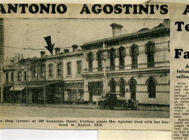
Photograph, Newspaper Photograph of Swanston Street businesses, 1944
When Andrew Black took occupancy of the shop ate 589 Swanston Street, Carlton, he was unaware that a few years earlier it had been the scene of a murder and became known as the 'pyjama case murder'. On 1st September 1934, the body of an unidentified woman dressed only in pyjamas was found near Albury, NSW. For the following decade it remained an unsolved mystery until 1944 when Tony Agostini was arrested and confessed to killing his wife. At the time of the murder, the Agostinis were living in the building, where Andrew later ran his shoe repair business. While the case was newsworthy in 1944, the Carlton shop featured in Melbourne's newspapers.A photograph of a portion of a newspaper article about a 1944 cold case murder in Melbourne.carlton, swanston street, andrew black, shoe repairs -
 Yarra Glen & District Historical Society
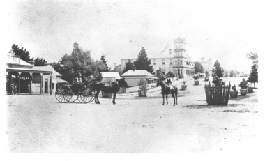
Black and white photographs, Bell Street Yarra Glen late 1890s
Photograph of Bell Street taken from junction with King Street. In the foreground is a horse and buggy with a male driver and passenger. To their right is a man on horseback. To the western side of Bell Street (left side of photograph) is A.H.Scott's General Store, next to which is the bootmaker. Further north along Bell Street is the house of Charles Bath, the Grand Hotel and the Colonial Bank. Bell Street is lined with trees surrounded by wooden tree guards.yarra glen, grand hotel, bell street, charles bath, street trees, general store, horse and rider, colonial bank, bootmaker, buggy, horse and buggy, horseman, a h scott, scott, wooden tree guards -
 Port Melbourne Historical & Preservation Society
Photograph - Friends of the Park float, Port Melbourne Festival, Pat Grainger, Feb 1989
This float was created by members of Friends of the Park, a group formed in 1987 against government proposals to turn the railway and reservation into a grand boulevard to service the proposed Sandridge City 'bayside' development. Members worked for months to make the decorations, added to a trailer. During the festival procession sausages were BBQ'd on the trailer and handed out to the crowd. On arrival at Murphy's Reserve all floats were put out of sight, and few saw the results of their efforts.One of 16 colour photos of Friends of the Park float for the February 1989 Port Melbourne Festival: Preparations for the procession forming by the Raglan Street flats - Nellie Thackruh and Maree Menzelcelebrations fetes and exhibitions, public action campaigns, andrea ellis, friends of the park, nellie thackruh, port melbourne festival -
Port Melbourne Historical & Preservation Society
Photograph - Friends of the Park float, Port Melbourne Festival, Pat Grainger, Feb 1988
This float was created by members of Friends of the Park, a group formed in 1987 against government proposals to turn the railway and reservation into a grand boulevard to service the proposed Sandridge City 'bayside' development. Members worked for months to make the decorations, added to a trailer. During the festival procession sausages were BBQ'd on the trailer and handed out to the crowd. On arrival at Murphy's Reserve all floats were put out of sight, and few saw the results of their efforts.One of 16 colour photos of Friends of the Park float for the February 1988 Port Melbourne Festival: Nellie Thackruh and Robert Frost with his BBQ on float, on Graham Street overpasscelebrations fetes and exhibitions, public action campaigns, friends of the park, nellie thackruh, robert frost, port melbourne festival -
 Surrey Hills Historical Society Collection
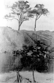
Photograph, Muriel Pornitz (deceased), Quarry on site of Grovedale Road - James Street Park
The photo is of a painting of the dam formed on land between Grovedale Road and James Street, Surrey Hills. It was painted in 1927 by Miss Muriel Pornitz, an art teacher, who lived in Grovedale Road. The land had been part of Mr James Maling Snr’s property and in the 1880s clay was removed to build houses, including his own located on the corner of Weybridge and James Streets. Maling grazed cattle on this area and used it as a dam. The land was subsequently made into parkland, the quarry / dam having been filled in after several drownings had occurred in the 1920s/1930s. See also SHP94, another copy of the same. Muriel Hedwig Lucy Pornitz lived at 22 Grovedale Road, Surrey Hills. She was born c1894 in Balwyn; died in Kew on 1 December 1982. She was the daughter of Konrad Pornitz (1864-1903) and his wife Charlotte Richardson Gooderidge (1863-1942), known as Tottie, who married in 1890. Konrad Pornitz is listed in the 1892 directory as living in Edgevale Road, Kew and the business Pornitz and Ross at 291 & 293 Little Collins Street, importers and commission merchants. The 1896 directory gives the Kew address as 176 Edgevale Road, Kew, however the business Pornitz and Ross was dissolved on 1st day of October 1892, by mutual agreement. Legal notice advised that: Mr Pornitz will hereafter carry on the business on his own behalf at the same address, under the style "Pornitz and Ross". Muriel is buried in Box Hill Cemetery (B-086-0042) along with Ulrich Horst Holm Pornitz known as Horst or Bon (d 1957) and Edith Olga Pornitz (d 1951), her brother and sister. A further sibling (Konrad b 1891) died in infancy. He is buried with his mother in Boroondara (Kew) Cemetery - C/E A 0366. Konrad died at his home 'Yarran' in Lane Cove Road, North Sydney on 31 October 1903; reported in the Sydney Morning Herald. Buried Gore Hill Cemetery, St Leonards, North Sydney. The headstone reveals he was born in Chemnitz, Saxony in 1863. Muriel was also known as Muriel Pornett. She studied at the South Australian School of Arts & Crafts in 1911 under James Ashton and Fred Britton, and at the Australian School of Etching in Sydney. She was also an illustrator and cartoonist. The photo, and the painting from which it is derived, documents the landscape prior to close settlement and is material to early building and farming in the Surrey Hills area.A black and white photograph of a painting of a landscape of parkland. Two trees are on top of a rise and are reflected at the bottom in water. The signature of the artist is in the bottom right corner: "AUST MP 192" (and the rest is cut off).(miss) muriel pornitz, grovedale road, james street, surrey hills, artists, parks and reserves, (mr) john butler maling, snr, quarry, dam, (miss) muriel hedwig lucy pornitz, box hill cemetery, muriel pornett -
 Melbourne Tram Museum
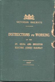
Document - Rule Book, Victorian Railways, "Victorian Railways Instructions re Working of the St Kilda and Brighton Electric Street Railway", 1926/27
Issued to employees of the VR St Kilda to Brighton electric street railway, superseding previous copies. The line closed in 1956. Note the spelling of the word "employe" with an accent over the e - an acceptable practice in Victoria at the time - a US based spelling. Book scanned into multiple parts. See Reg Item 3508 for a "Supplement to the Book of Instructions re the working of the St Kilda and Brighton Electric Street Railway, dated 1/1/1915", item 7518 for a June 1907 version, and 7580 for instructions issued in 1911.Demonstrates a Victorian Railway Rule book for electric tramways or Street Railways.Rule Book - 156 pages, five sewn sections within a green coloured Rexene heavy card with glued endpapers with the title "Victorian Railways Instructions re Working of the St Kilda and Brighton Electric Street Railway" and "1927" in gold block. Dated 1 June 1926. Has a table of contents and index - gives definitions - "trams" vs "street railways", general instructions, hand signs, working of cars, working of traffic over single and double line, staff and ticket systems, air brakes, permanent way, overhead, fares, appeals of employees against penalty and electric shock.Copy 3 has stamp of the "Westinghouse Brake Inspector" and "Lloyd Rogers" in ink on the inside front cover. On page 94 and 95 has notes in pencil about the air braking system - may have been for a following issue.trams, tramways, victorian railways, vr, st kilda brighton, rules, employees, safeworking -
Federation University Historical Collection
Photograph, Drawing of Sturt Street, Ballarat
Photograph of a drawing of Sturt Street, Ballarat.sturt street ballarat -
 Stawell Historical Society Inc
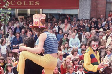
Photograph, Ian McCann, Main Street - Gold Reef Mall, c 1987
Street Performers and large crowd in Mallgold reef mall -
Whitehorse Historical Society Inc.
Map, Street Index refer to D76 map, 1993
List of street names in alphabetical orderList of street names in alphabetical orderList of street names in alphabetical ordermaps, city of nunawading -
 Ballarat Heritage Services
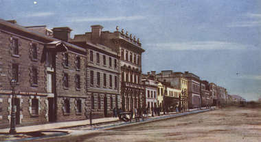
Photograph - Image, Elizabeth Street Melbourne Looking North, 1865
A colour image Elizabeth Street, Melbourne. princes bridge, queen's bridge, yarra river, rowboats -
 Ballarat Heritage Services
Photograph - Colour, Eureka Street State School Honor Board
Photograph of the Eureka Street State School.eureka street state school, eureka street state school honor roll, world war one -
 Kew Historical Society Inc
Photograph, 'Roseneath', Pakington Street, c. 1960
Roseneath is an A-listed house in the City of Boroondara. It was built between 1858 and 1860. This work forms part of the collection assembled by the historian Dorothy Rogers, that was donated to the Kew Historical Society by her son John Rogers in 2015. The manuscripts, photographs, maps, and documents were sourced by her from both family and local collections or produced as references for her print publications. Many were directly used by Rogers in writing ‘Lovely Old Homes of Kew’ (1961) and 'A History of Kew' (1973), or the numerous articles on local history that she produced for suburban newspapers. Most of the photographs in the collection include detailed annotations in her hand.The Rogers Collection provides a comprehensive insight into the working habits of a historian in the 1960s and 1970s. Together it forms the largest privately-donated collection within the archives of the Kew Historical Society.Facade of Roseneath, Pakington Street, Kew. Roseneath, 37 Pakington St., Kew. Built between 1858-1860. E.J. Dunns home. & dogs all soldroseneath, pakington street, kew, dorothy rogers -
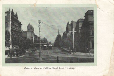 Kew Historical Society Inc
Postcard, General View of Collins Street from Treasury, 1920-1950
This work forms part of the collection assembled by the historian Dorothy Rogers, that was donated to the Kew Historical Society by her son John Rogers in 2015. The manuscripts, photographs, maps, and documents were sourced by her from both family and local collections or produced as references for her print publications. Many were directly used by Rogers in writing ‘Lovely Old Homes of Kew’ (1961) and 'A History of Kew' (1973), or the numerous articles on local history that she produced for suburban newspapers. Most of the photographs in the collection include detailed annotations in her hand. The Rogers Collection provides a comprehensive insight into the working habits of a historian in the 1960s and 1970s. Together it forms the largest privately-donated collection within the archives of the Kew Historical Society.Collins Street, Melbourne looking west.collins street, melbourne, dorothy rogers, postcards - melbourne -
 Federation University Art Collection
Drawing - Mixed media drawing, 'Camp Street Series' by Duncan Lannan, 2000
Duncan LANNAN (1972- ) Duncan Lannan undertook a Diploma of Arts (Visual Arts) at RMIT between 1995 and 1996. A further two years study at the University of Ballarat (now Federation University Australia) saw Duncan Lannan awarded a Bachelor of Arts (Visual Arts) in 2000. He completed a Graduate Diploma od Education at the University of Melbourne in 2001. This item is part of the Federation University Art Collection. The Art Collection features over 1000 works and was listed as a 'Ballarat Treasure' in 2007.Framed drawings of Ballarat's Camp Street.art, artwork, camp street, ballarat, duncan lannan, alumni, school of business collection -
 Ballarat Heritage Services
Photograph, Clare Gervasoni, 49a Webster Street. Ballarat, 2020, 12/10/2020
House at 49a Webster Street. 2020webster street, ballarat, architecture -
 Kilmore Historical Society
Photograph, Sydney Street & Clarke Street
15cm x 10cm coloured photograph of the construction site on the corner of Sydney Street and Clarke Street. The site is now Coles Supermarket, Aldi, Liquorland, McDonalds, Coles Express, Kilmore Pizza Factory. Multiple photos taken over a period of time before the structure was being built. Brewery Hill can be seen in the backgroundWritten on the back: Site being prepared for the new Coles buildingconstruction, supermarkets -
 Surrey Hills Historical Society Collection
Photograph, 'Garmure', 26 Russell Street, Surrey Hills in 1988
‘Garmure’, 26 Russell Street, Surrey Hills was built c. 1887 and renovated c1988. This photo was taken after renovation of the rear of the house when the corner tower was added. Occupants: 1890: Mr Caffin 1910: Miss Agnes Campbell Hutchinson Orr 1930 – 1988: Sextons Miss Orr was born in Hutchesontown, Glasgow to Francis Orr (1834-1859) and Jane McDonald. Her father died soon after her birth and her mother married Thomas Blood. She had a half-brother Robert McDonald Blood. In 1903 she, her brother and mother were living in Boundary Road. She is buried with them in Kew Cemetery. She died aged 57 on 1 December 1926. A black and white photograph of a Queen Anne Style weatherboard house with a return veranda. The roof is corrugated iron. There is a picket fence along the front and a driveway on the left had side of the building.garmure, house names, (mr) - caffin, sexton family, queen anne style, corrugated iron, weatherboard, russell street, surrey hills, (miss) agnes campbell hutchinson orr -
 Eltham District Historical Society Inc
Photograph, Brougham Street, Eltham, early 1900s, 1900s
Colour photograph of a poor quality photograph (in album) of Brougham Street, Eltham looking east from near Susan Street, early 1900seltham, brougham street, wellington street, susan street -
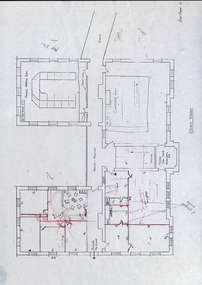 Federation University Historical Collection
Building Plan, School of Mines Lydiard Street Administration Building, Late 1970s
Office spaces in SMB, Lydiard Street Administration Building at street level. Each of the five photocopies shows a different arrangement of the Council Room.ballarat school of mines, administration building, plans, lydiard street, offices -
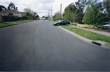 Whitehorse Historical Society Inc.
Photograph, Victoria Street, Mitcham, 1/10/2000 12:00:00 AM
Coloured photograph of of Victoria Street looking east. Car is exiting from multi storey car park in Edward Street into Victoria Avenue.victoria street, mitcham -
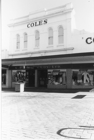 Stawell Historical Society Inc
Photograph, G. J. Coles Shop at 113 Main Street Stawell -- Different Angle
Shop 113 Main Street Stawell once Coles retail store now Lyal Eales. Coles store operated around 1984, 1991. Lyal Eales opened in 2013.A different view of the Coles retail store when the street was turned into a mall, as the photo shows a brick pavement in front of the building. The entrance area between two display windows with a third display windows to the right. The upper level has 5 arch shaped windows.COLESg. j. coles retail shop stawell -
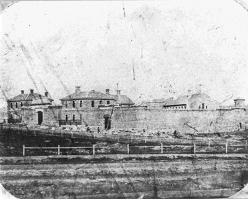 Federation University Historical Collection
Photograph - Photograph - Black and White, Former Ballarat Gaol, c1861, c1861
The former Ballarat Gaol was commenced in 1856 and completed in 1862, This view looks up Lydiard Street South, and was taken before the Ballarat Courthouse was built south of the gaol in 1868. The wall was built from quarried basalt with local bricks. A system of burning the lime mortar between the joints and the shape of the wall meant it had a high degree of stability. From 1870 on more buildings were constructed and these became the School of Mines and Industries Ballarat. The Gaol closed in 1965. This image shows the Ballarat Gaol c. 1861 giving us an understanding of what the site looked like before all the changes that have occurred over the years since the gaol closed and other organisations have had the site. Black and white image showing the former Ballarat Gaol from Lydiard Street South.Label on underneath photograph: The Ballarat Gaol, c.1861 - This view looks up Lydiard Street towards our present school entrance. The gaol buildings remain unchanged . Note that the Court House, now S.M.B's Elec. classrooms, has not yet been built on the right hand side of the gaol.ballarat gaol, ballarat school of mines, gaol, m113, lydiard street, courthouse, lime mortar, lydiard street south -
 Stawell Historical Society Inc
Photograph, Upper Main Street Stawell with the Patrick Street & Main Street corner at centre of Photo 1880
Stawell Township - Upper Main Street 1880. Patrick Street Main Street corner at centre of Photo.stawell -
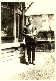 Federation University Historical Collection
Photograph - Black and White, Vernon Holt, Frank Wright at 6 Pleasant Street North, Ballarat, 1923, Jan 1923
Frank Wright was a renown resident of Smeaton, where he was born. He lived at Laura Villa, and attended Smeaton State School. His father William was a gold miner and his mother's name was Sarah. Their family won many singing and instrumental awards. Frank was tutored by Percy Code and was awarded a gold medal for the highest marks in the ALCM examinations in the British Colonies at the age of seventeen years. He became the Australian Open Cornet Champion by the age of eighteen. A year later, Frank conducted the City of Ballarat Band, and later the Ballarat Soldiers’ Memorial Band. He formed the Frank Wright Frisco Band and Frank Wright and his Coliseum Orchestra. These bands won many South Street awards, and Frank as conductor won many awards in the Australian Band Championship contest. In 1933 Frank Wright sailed to England to conduct the famous St Hilda’s Band and was later appointed Musical Director of the London County Council, where he organized many amazing concerts in parks, in and around the London district. He was made Professor of Brass and Military Band Scoring and conducted at the Guildhall of Music and Drama. Frank was often invited to adjudicate Brass Band Championships around Europe, in Australia, including South Street and in New Zealand. The Frank Wright Medal at the Royal South Street competition is awarded to an individual recognized as making an outstanding contribution to brass music in Australia.Black and white photograph of a man standing standing on a path beside the wall and windows of a house. The man is dressed in a suit and is holding a cornet. The place is 6 Pleasant Street, North Ballarat and the man is Frank Wright.Written is pen on the back - Frank Wright 21, 6 Pleasant St N. Ballarat, Taken by Vernon Holt, Jan 1923frank wright, cornet, conductor, ballarat, vernon holt -
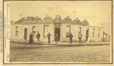 Bacchus Marsh & District Historical Society
Photograph, Court House Hotel Main Street Bacchus Marsh 1883
This building on the corner of Court House Place and Main Street Bacchus Marsh was a licensed hotel since 1864. Prior to 1864 the building was in use as a saddlery business, established by Joseph Purday and Alfred Smith. In 1864, Purday and Alfred Tanner converted the shop to a hotel. Tanner, followed by his wife Ann, were licensees until 1892. The hotel signage above the door features the Prince of Wales feathers, an acknowledgement of the Prince of Wales Volunteer Light Horse Werribee unit which used the hotel for their meetings. In 1911 the single-storey hotel was demolished and a two-storey brick hotel was built. The identities of the five men and one woman in the photo are not known. The woman at the left of the group is possibly Ann Tanner who was the licensee around the time this photograph was taken. Small sepia unframed photograph on card with gold border framing photograph. Housed in the album, 'Photographs of Bacchus Marsh and District in 1883 by Stevenson and McNicoll'. A group of five men and one woman can be seen standing in front of the Court House Hotel building, Main Street Bacchus Marsh. A large ornate sign around the roofline bears the words “Courthouse Hotel”. Above the door a sign featuring the Prince of Wales feathers also has the name “Ann Tanner.” One of the men is displaying a document which apparently is of some importance, now lost.On the front: Stevenson & McNicoll. Photo. 108 Elizabeth St. Melbourne. COPIES CAN BE OBTAINED AT ANY TIME. On the back: LIGHT & TRUTH inscribed on a banner surmounted by a representation of the rising sun. Copies of this Portrait can be had at any time by sending the Name and Post Office Money Order or Stamps for the amount of order to STEVENSON & McNICOLL LATE BENSON & STEVENSON, Photographers. 108 Elizabeth Street, MELBOURNE. stevenson and mcnicoll 1883 photographs of bacchus marsh and district, hotels bacchus marsh, court house hotel bacchus marsh -
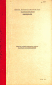 Melbourne Tram Museum
Document - Report, Melbourne & Metropolitan Tramways Board (MMTB), "Swanston Street Underground Tramway City Road to Bouverie Street", Jun. 1972
Report - Foolscap, card covers, red binding strip, 12 sheets + 4 drawings (fold out), titled "Swanston Street Underground Tramway City Road to Bouverie Street", detailing the proposal, including costs, issues, drains, obstructions. Includes cross sections of the tunnels and notes on public access. Dated June 1972. Drawings not scanned.Has "Lees" in ink on top right hand corner.trams, tramways, underground tramways, swanston st, reports, new tramways -
 Surrey Hills Historical Society Collection
Photograph, 7-9 Russell Street 'Vavau' / 'Handsworth'
7-9 Russell Street has had 2 house names: ‘Vavau’ and ‘Handsworth’. Early occupants were: 1887–1892: George Legge, builder. 1892-1902: Arthur Greenwood – storeman and missionary in Tonga, hence the house name ‘Vavau.’ 1902–1950s: Mr and Mrs George Jackson and family of 10 children. Alice Jackson was a specialist manufacturing jeweller and set up a jewellery business with her husband. He and the family continued it until late 1950s. 1978–1986: Sold in late 1950s; Ruth Theodoris and her husband Peter bought it; sold 1986. The house is extant in 2020 and was last sold in May 2009 for $1,315,000. Real estate agent photos from the time reveal it has had a large extension at the rear. A black and white photograph of a late Victorian Boom Style house with ornate filigree lacework on the verandah. There is a picket fence along the front. Scalloped lace curtains adorn the front windows.surrey hills, russell street, (mr) george jackson, (mr) arthur greenwood, (mrs) alice jackson, jeweller, (mrs) ruth theodoris, (mr) peter theodoris, victorian boom style, vavau, handsworth, house names, (mr) george legge -
 Flagstaff Hill Maritime Museum and Village
Medal - Token, Richard Parker, ironmonger, Mid-to-late 19th century
This copper penny token was issued in Geelong by ironmonger R. Parker. Richard Parker was an early settler in Victoria. He had a general store in Elizabeth Street, then Collins Street, Melbourne for five years before moving to Geelong in 1844. He soon established several branches of his ironmonger business in towns around Victoria. He encouraged trade by providing customers with the small change of penny tokens in exchange for their more valuable and less convenient silver coins. The token carried a surcharge and was overstamped with the mane of W. Kernot. William Charles Kernot was a chemist at Chillwell, Geelong. The token is of historical significance, representing a form of currency used in Australia's colonial era before Australia had official currency.Token coin; a round copper one penny token. Obverse had promotional text and a sketch and was overstamped with a name. Reverse had the image of a woman holding up a set of balance scales in one hand and a cornucopia in the other, standing beside the sea, with a three-masted sailing ship in the background, There is a formed hole in the metal; on the obverse, it is on the top of the design, on the reverse it is on the bottom of the design. It advertises R. Parker, Ironmonger, Moorabool Street, Geelong, overstamped with the name W. Kernot.Embossed on the obverse: "R. PARKER / IRONMONGER. / MOORABOOL STREET / GEELONG" "W. KERNOT" Embossed on reverse: "AUSTRALIA"warrnambool, shipwreck coast, flagstaff hill, flagstaff hill maritime museum, flagstaff hill maritime village, medallion, coin, token, promotional medallion, one penny, r parker, ironmonger, moorabool street geelong, w. kernot, richard parker, currency, australian currency