Showing 11140 items
matching planning
-
 RMIT Design Archives
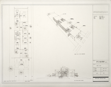
Architectural drawings, Proposed Family Residence for Mr. & Mrs. Spedding at Lot 2 Bolton Avenue, Brighton
Sketh plansink, acetate -
 University of Melbourne, Burnley Campus Archives
Plan - Sketch, Widening road for parking. Buildings in College area occupied by other branches, c. 1950
Sketch plan.burnley school of horticulture, roads -
University of Melbourne, Burnley Campus Archives
Plan, Science Bench, c. 1960
Plan No. 3.science -
Friends of Ballarat Botanical Gardens History Group
Plan - Concept Design The Fernery Ballarat Botanic Gardens, Andrew Laidlow, August 2014
Photocopy of Planballarat botanical gardens, fernery, concept design, fernery layout -
Port Melbourne Historical & Preservation Society
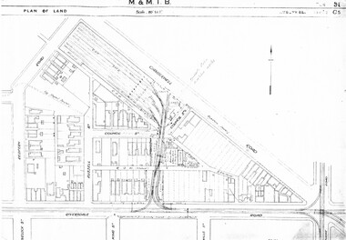
Map - MMBW, c. 1894
Melbourne and Metropolitan Board of Works Plan No. 323,330, 335, 336 Segments shown: As Plan No. Large scale plan of lagoon fill area (40'=1")engineering - board of works, sandridge lagoon, transport - tramways, engineering - canals and drainage, built environment, gasworks, business and traders - hotels -
 Bendigo Historical Society Inc.
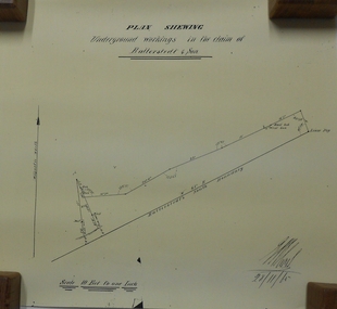
Document - MARKS COLLECTION: UNDERGROUND WORKINGS BALLERSTED & SON
Plan on white paper (copy) of underground workings. On top of plan 'Plan Showing Underground Workings in the claim of Ballerstedt & Son' On bottom date written 29/11/65. Plan shows lease peg, southern boundary of claim.bendigo, mining, ballerstedt & co -
 Bendigo Historical Society Inc.
Plan - MARKS COLLECTION: PLAN OF UNDERGROUND WORKINGS CINDERELLA COMPANY, JOHNSON'S REEF
Plan on heavy parchment paper: on top of plan 'Plan of the underground workings Cinderella Company, Johnson's Reef' Lh side of plan 'Kent Company's Ground' on bottom: Tipper and Company. Written on bottom surveyed 13/7/64.bendigo, mining, cinderella company -
University of Melbourne, Burnley Campus Archives
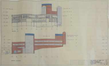
Plan - Photocopy, Percy Everett, New School of Primary Agriculture & Horticulture - Burnley Gardens, 1945
Floor plans and elevations of new building designed by Percy Everett, Chief Architect, Public Works DepartmentPhotocopies, reduced in size, of Original Plans for the Administrative Building. Signed, Percy Everett, Chief Architect, Dept of Public Works, Victoria, dated 26.09.1945 (1) UCB.2.135 Ground Floor and First Floor. (2) UCB.2.136 Transverse Section, Longitudinal Section. N.B. University of Melbourne - Property and Services has a better copy.buildings, percy everett -
 Bacchus Marsh & District Historical Society
Map, Bacchus Marsh Suburban Allotments Parwan Road Lodge & Dunn's Paddocks 1888
This map was created as a plan for an auction of land close to the Bacchus Marsh Railway Station. The auction took place on 23 October 1888. 102 allotments of land from an area known as Lodge and Dunn's paddocks was offered for sale. A single page paper map showing allotments of land for sale along the Parwan Road in Maddingley. The map is pasted into a bound volume containing 76 maps or plans in total. High resolution digital image stored on BMDHS computer network. land sales bacchus marsh, land sales maddingley, bacchus marsh victoria maps, maddingley victoria maps -
 Melbourne Tram Museum
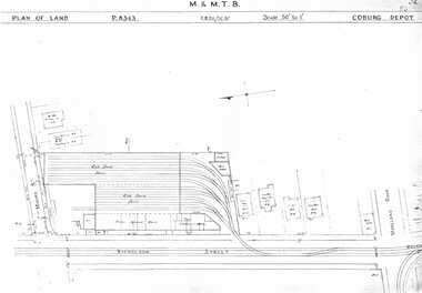
Drawing, Melbourne & Metropolitan Tramways Board (MMTB), "Coburg Depot", c1937
Set of two photocopied plans or drawings on A3 sheet of Coburg Depot - c1937 .1 - P8343 - Plan showing depot block and building plan with adjacent private houses and properties .2 - P8344 - Detail plan of depot - with notes about possible plans and changes - 4/1967. shows substation location.trams, tramways, drawings, depots, property, coburg depot, substation -
 Federation University Historical Collection
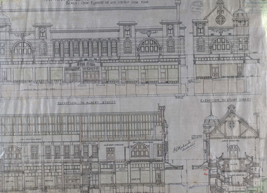
Plan - Architectural Plans, Australian Natives' Association Ballarat Branch No 4 Architectural Plans
Percy Richards taught Architecture and Building Construction at The Ballarat Art School - a division of Ballarat School of Mines from 1918-1921. He was responsible for the design of a number of buildings in the district. This item is the "Specification of work required to be done and materiaals required for construction of the new A.N.A. Building at the corner of Sturt, Albert and Lewis Streets, Ballarat. Prepared by and to the satisfaction of P.S. Richards, A.R.V.I.A. Architect and subject to the General Conditions of Contract." "BALLARAT CITY A.N.A. BALLARAT, Wednesday — The Ballarat City branch, A.N.A., which was formed nearly 50 years ago, ranks fourth on the association records, but several of the members were prominent in establishing the association in Melbourne a year or two earlier. On the past half-year's operations the total funds increased by £1558/18/3 to £29.389/11/11. The membership now totals 949. The committee recommended that as the property at the corner of Sturt and Albert Streets, which had been intended as the site of a new hall, had been sold, steps should he taken to remodel the present hall, and bring It up to date. The report was adopted." (The Herald, 18 June 1924)Fourteen detailed drawings showing the specifications for each section of the new A.N.A. building for Ballarat. A 24 page document submitted to the Public Health Department, Victoria, received 15 January 1918 and a 3 page document related to Reinforced Concrete Particulars. All contained in a labelled black metal cylinder.A.N.A.4. PLANS painted on side and lid. Signature of P.S. Richards.ana, australian natives' association, architecture, percy richards, building specifications, ballarat, technical art school ballarat, materials, construction, p.s. richards, percival selwyn richards -
Moorabbin Air Museum
Book (item) - CAC Collection - Technical Data Bell Helicopter Company
Electromagnetic Compatibility Test Plan For Australian Army 206B-1 Helicopter -
Moorabbin Air Museum
Book (item) - CAC Collection - Technical Data Bell Helicopter Company
Electromagnetic Compatibility Control Plan For The Australian Army 206B-1 Helicopter -
 Dutch Australian Heritage Centre Victoria
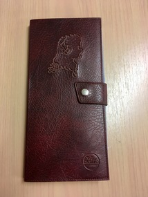
Road Map, Nederland
Cleverly folded 1:250,000 road map produced in Dutch, French, German and English containing not only the Dutch road network but also much information of interest to tourists. It is enclosed in a brown imitation leather cover that closes with a stud. Optimal ease of use through patented Falk folding mode.Falk Plan. Road Map. Netherlands. Repeated in Dutch, French and German. -
Port Melbourne Historical & Preservation Society
Plan - Unnamed Street, c. 1893
Plan for "unnamed street" (later Edwards, Morley) Loan Works 1893, plan no. 11 engineering - roads streets lanes and footpaths -
 Bendigo Historical Society Inc.
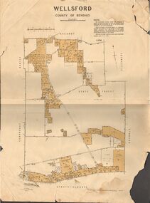
Map - JACK FLYNN COLLECTION: WELLSFORD, 15/12/1941
Map: Parish of Wellsford, County of Bendigo. Parish plan. 2 copies of the same plan.map, bendigo, parish plan, wellsford -
Whitehorse Historical Society Inc.
Map, Eastern Freeway Extension, 2002
Extension of Eastern Freeway: Plan of Deep Creek Road paths, drainage and alignment plan.Extension of Eastern Freeway: Plan of Deep Creek Road paths, drainage and alignment plan.Extension of Eastern Freeway: Plan of Deep Creek Road paths, drainage and alignment plan.deep creek road, mitcham, eastern freeway extension, eastlink -
University of Melbourne, Burnley Campus Archives
Plan - Photocopy, Proposed Reserve for Horticultural and Experimental Garden in the Survey Paddock Richmond, 1862-1948
Photocopy of Plan Gazetted 01.08.1863. From Central Plan Office Department of Natural Resources.Original signed by Clement Hodgkinson, Deputy Surveyor General. Stamped Department of Lands and Survey 7.12.48 Neg.18377. Handwritten notes on back "Melb Roll 23, R.19(A)"burnley, horticultural and experimental garden, survey paddock, richmond, clement hodgkinson -
 Kiewa Valley Historical Society
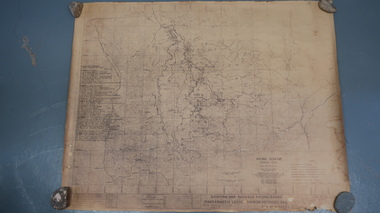
Map - Kiewa Scheme General Plan
Existing and possible future roads are numbered and named 1 - 45. The plan is based on an aerial photos taken March 1945. It includes revisions up to 1951. Signed by H.H.C. Williams, construction engineer. Mountains, rivers, roads and SECV places are named, also SECV infrastructure and construction eg. workers camps, Power stations.Significant for the information re the Kiewa Hydro Electric Scheme's development.Yellowed paper with brown print. Kiewa Scheme general plan showing its development. A lot of information is recorded. Note: Dyeline print was used which causes fading when exposed to light. Handwritten: 'Bob Duncan'bob duncan, kiewa hydro electric scheme, secv, khes development -
Whitehorse Historical Society Inc.
Article, East Burwood Tram Line, 27/05/1992 12:00:00 AM
The $6.5 million stage 1 extension to East Burwood tramline will start next month.The $6.5 million stage 1 extension to East Burwood tramline will start next month. The extension will be from Middleborough to Blackburn Road and the track construction will begin February 1993. The initial plan is to extend right to Knox City. Construction will be by a combination of VicRoads, MET and private contractors.The $6.5 million stage 1 extension to East Burwood tramline will start next month. tram services, victoria. ministry of transport, vicroads, met, burwood east -
Port Melbourne Historical & Preservation Society
Plan - Floor Plans, Proposed Port Melbourne Library, Fred Cook, City Engineer, 1938
From set of plans for the proposed Library - City of Port Melbourne 1938 4 sheets with ground floor plan, roof plan, 1st floor plan, side elevation, elevation. Two on paper, hand coloured; two on tracing paper."City of Port Melbourne Proposed Library":Fred Cook City Engineerbuilt environment - civic, city engineers, fred cook, port melbourne library -
 Kew Historical Society Inc
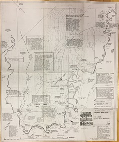
Plan, Loder & Bayly, Heidelberg: Historic River Landscape Assessment, 1982
Gwen McWilliam is well known as an authority on the history of Boroondara and the author of a large number of books and pamphlets about the City. She was awarded the medal of the Order of Australia in 2001 ‘for service to the community of Hawthorn and district, particularly through the research, documentation and publication of its history.’ This map from her collection was donated to the Kew Historical SocietyPlan of Heidelberg, annotated with details about the occupancy pre and post European settlement. The plan also contains geological references. The plan is included and analysed in volume 2 of the Heidelberg Conservation Study (1985). The original plan was published created in 1982. Printed annotationscity of heidelberg, yarra valley, historic plans -- heidelberg -
 Melbourne Tram Museum
Drawing, Melbourne & Metropolitan Tramways Board (MMTB), "Camberwell Depot", Original drawings - c1937, 1985
Set of three photocopied plans or drawings on A3 sheet of Camberwell Depot - c1937 .1 - P? - Plan showing depot block and building plan with adjacent private houses and properties .2 - P8410 - Detail plan of depot - part missing on the left hand side. .3 - P8411 - Plan of Mess Rooms and offices.trams, tramways, drawings, depots, property, camberwell depot -
 Bendigo Historical Society Inc.
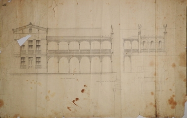
Plan - MARKS COLLECTION: PLAN FOR TWO STOREY OPEN VERANDAH ADDITION TO FRONT AND SIDE ELEVATIONS TO FOTUNA VILLA FOR GEO. LANSELL ESQ
Fortuna Villa was owned from 1855 to 1871 by Christopher and Theodore Ballerstedt, Australia’s first mining magnates. In 1871 it was purchased by George Lansell (The Quartz King) being one of Australia’s most successful and adventurous nineteenth century gold mine owners and speculators. Lansell made numerous alterations extensions to the building and remained in the Lansell family until 1935Plan shows front and side elevations only for the addition of a two storey lacework verandah to Fortuna Villa for George Lansell Esq. Black ink hand drawn plan for verandah elevations Plan badly damaged with water damage, flocking, tears and a hole in the paper plan. Hand drawn additions to the plan with pencilbendigo fortuna villa, george lansell -
Glenelg Shire Council Cultural Collection
Plan - Glenelg Shire Council Plan 2004-2008, c. 2004
Glenelg Shire Council Plan 2004-2008. -
 Federation University Historical Collection
Plan - Plans, Ballarat School of Mines Albert Street Buildings, 1979
The Trade Workshops became known as the M.B. John Building, and later housed Ballarat Tech.Eight printed plans with coloured shading of SMB Albert St buildings: .1) Locality Plan .2) Trade Workshop Site Plan .3) Trade Workshop Floor Plan Level A & B .4) Trade Workshop Floor Plan Level C .5) Trade Workshop Floor Plan Level D .6) Trade Workshop Floor Plan Level E .7) Trade Workshop West Elevation and Sections .8) Trade Workshop North Elevations and Sections building plans, smb trade workshops, ewan jones and associates pty ltd, architectural plan, m.b. john building, albert street -
 Wonga Park Community Cottage History Group
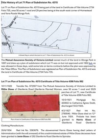
Document - Title History, Title History of Lot 71 PS 4315 Wonga Park
The history of Lot 71 on Plan of Subdivision No. 4315 Wonga Park (area 50 acres 1 rood and 29 perches) starts in 1902 when the subdivision was registered by the Mutual Assurance Society of Victoria Limited then transferred to Millie Glass, Married Woman of Glenferrie. The history of registered owners who have a connection with the Lot include Harris Glass, Janie Glass, Annie Glass, Charlotte Soloman, Barnett Glass, Sydney Charles Mackie, Arno Herbert Neuparth and Valerie June Neuparth, inter alia.Archive file for Lot 71 on Plan of Subdivision No. 4315 Wonga Park, containing title history documents and research. Documents include Certificates of Title Volume 4390 Folio 992, Volume 5924 Folio 711, Volume 8723 Folio 836, Volume 8995 Folio 834, Volume 9016 Folio 994, Volume 10006 Folio 334 and Plan of Subdivision No. 3039575. -
 Federation University Historical Collection
Book, G.J. Harrison, Review of Development Plan for the Mount Helen Campus Ballarat, 1975, 1975
In 1967 the site for the Mt Helen Campus was selected and purchased to permit the tertiary division of the Ballarat School of Mines - the Ballarat Institute of Advanced Education (BIAE) to move from the crowded Lydiard Street site, to occupy new accommodation designed for the purpose. The brief given to the campus master planners called for the creation of a modern, attractive, efficient and stimulating concept. It called for careful landscaping and enhancement of the environment, but above all it demanded flexibility for an unpredictable future. During 1974 major new directions were made at Government level quite beyond the scale of change that had been foreseen in 1967. This change was to be that of merging BIAE and the State College of Victoria at Ballarat (formerly Ballarat Teachers' College) into one large new college of broadened scope. By the end of 1974 joint committees representing the still separate, autonomous Councils of the two institutions had agreed on the means of achieving the merger to the extent that a new brief as prepared and given to G.J. Harrison, one of the original master planners who had been chosen to revise the plan to meet the new needs. Yellow soft covered book of 63 pages reviewing the Development Plan for Mount Helen Campusuniversity of ballarat, ballarat institute of advanced education, mount helen, master plan, ballarat college of advanced education, mb john, ian gordon, pdf, development plan, mount helen campus, g.j. harrison, state college of victoria ballarat, m.b. john, canadian valley, aquinas college, site survey, land use zones, landscaping, campus plan, mt helen campus -
 Bendigo Historical Society Inc.
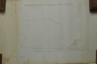
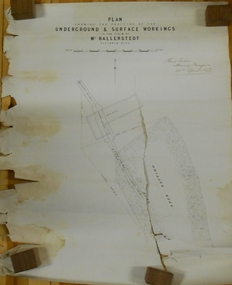
Document - MARKS COLLECTION: GROUND AND SURFACE WORKINGS BALLERSTEDT MINE VICTORIA HILL
Original plan in very poor condition, torn in centre (A copy is listed under No. 8300.36l). On top of plan 'Plan showing the position of the ground and surface workings in the claim of Mr. Ballerstedt Victoria Hill' Plan is signed by Thomas Forbes, Mining Surveyor, 22nd. April 1868. Plan shows house outline and open cut.bendigo, mining, ballerstedt mine victoria hill -
University of Melbourne, Burnley Campus Archives
Plan, Base Plan Front Garden Maughan Parade, c. 1980
1. Tracing paper and paper copies, Site Plan. Scale 1:100. Drawn by JK. 2. Site plan Scale 1:200 (plan of whole site)maughan parade, gardens