Showing 16996 items
matching plenty-river
-
 Stawell Historical Society Inc
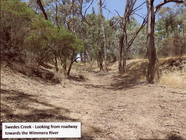
Photograph, Swedes Creek Looking looking towards the Wimmera River 2017 -- Coloured
Colour Photo of Swedes Creek Looking from roadway towards the Wimmera River 2017water -
 St Patrick's Old Collegians Association (SPOCA)
Photograph - Students, 1920s
-
 Orbost & District Historical Society
black and white photographs, Snowy River Mail, October 1987
In 3098.1 from L-R are John Pritchard and Graeme Rodier. Jeff Wilson is in 3098.2. Both photographs are connected to Adult Learning TAFE and CEP. These photographs were taken at the Curriculum and Technology in Schools workshop held in Bendigo, Victoria in October 1987. Eighty rural primary schools were involved including many from East Gippsland. From the Snowy River Mail; " A large number of technologies was......demonstrated at the conference. Participants were given hands on experience with audio and computer conferencing, CD Rom. an Invicon booth ( individual video console (INVICON) enables any teacher to produce short, relevant teaching videos for individual pupils without assistance), packet radio, videodisk, robotics and many more...." This is a pictorial record associated with education in Orbost.Two black / white photographs of two men seated at a desk with computers. The man on the right is holding a phone.education-east-gippsland tecnology -
 Port Melbourne Historical & Preservation Society
Book, Meyer Eidelson, "Yalukit Willam - The River People of Port Phillip", Feb 2015
Written as part of the City's reconciliation program and with the assistance of Carolyn Briggs over a two year program."Yalukit Willam - The River People of Port Phillip" by Meyer Eidelson: illustrated soft cover, 99 pages plus fold out map at back cover is WFE Liardet watercolour of Emerald Hill corroboree and history of Koori activity pre and during European occupationSigned IFC by author, and Carolyn Briggs, Boon Wurrung Foundation, "yours with respect"australian aborigines, parks and gardens, natural environment, meyer eidelson, carolyn briggs, derrimut, yalukit willam clan, boon wurrung, kulin nation, bunjil, george robinson, ben bow, louisa briggs, wilbraham frederick evelyn liardet, wfe liardet, josephine liardet, emerald hill, william buckley, kurburu (the bear) -
 Kew Historical Society Inc
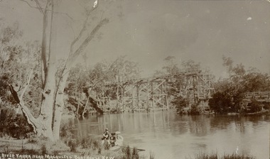
Postcard, River Yarra near Macauleys' Boathouse Kew
Sepia postcard of the Zig-zaf Bridge joining Yarra Bend and Studley Park. In the foreground is a rowboat in which a man is standing, behind whom are two women in hats and a young child. The man appears to be pushing the boat away from the Bank. In the distance is the wooden Zig-Zag Bridge, constructed in the 1870s to link the Yarra Bend and Kew Lunatic Asylums. [Destroyed by flood, 1929.]Obverse: "River Yarra near Macauleys' Boathouse Kew". Reverse: "Zig Zag Bridge / Gift from L Bennett 1980 / Bridge between Old Asylum & new Mental Hosp. / Kew side"zig-zag bridge -- kew (vic.), bridges -- river yarra, bridges -- kew (vic.) -
![Junction of the River Watt and Contentment Creek / [by] Nicholas Caire, circa 1876](/media/collectors/550653872162f11fb04854aa/items/57760437d0cdd10a5c49fc3e/item-media/57760510d0cdd10a5c4a8f9c/item-fit-380x285.jpg) Kew Historical Society Inc
Kew Historical Society IncPhotograph, Anglo-Australasian Photographic Company, Junction of the River Watt and Contentment Creek, c. 1876
Nicholas Caire was born on Guernsey in the Channel Islands in 1837. He arrived in Adelaide with his parents in about 1860. In 1867, following photographic journeys in Gippsland, he opened a studio in Adelaide. From 1870 to 1876 he lived and worked in Talbot in Central Victoria. In 1876 he purchased T. F. Chuck's studios in the Royal Arcade Melbourne. In 1885, following the introduction of dry plate photography, he began a series of landscape series, which were commercially successful. As a photographer, he travelled extensively through Victoria, photographing places few of his contemporaries had previously seen. He died in 1918. Reference: Jack Cato, 'Caire, Nicholas John (1837–1918)', Australian Dictionary of Biography.An original, rare photograph from the series 'Views of Victoria: General Series' by the photographer, Nicholas Caire (1837-1918). The series of 60 photographs that comprise the series was issued c. 1876 and reinforced a neo-Romantic view of the Australian landscape to which a growing nationalist movement would respond. Nicholas Caire was active as a photographer in Australia from 1858 until his death in 1918. His vision of the Australian bush and pioneer life had a counterpart in the works of Henry Lawson and other nationalist poets, authors and painters.Albumen Silver Photograph, mounted on Board. printed in ink on support l.c.: JUNCTION OF THE RIVER WATT AND CONTENTMENT CREEK. / COPYRIGHT REGISTERED. printed in ink on support reverse c.: VIEWS OF VICTORIA. / (GENERAL SERIES.) / No. 1. / JUNCTION OF THE RIVER WATT AND CONTENTMENT CREEK. / This scene is situated about two miles to the westward of Fernshawe, a small but extremely romantic township. / The river, at this juncture, is crossed by a fallen tree, as may be seen in the illustration. The track which is seen on / the opposite side of the river leads to the summit of Mt. Munda (3,500 feet high), 4 miles distant, from which place / visitors can see the Australian Alps, in all their mighty grandeur, stretching for hundreds of miles on either side, / and, as far as the eye can reach, impressing a beholder with the appropriateness of their title, being that of the Great Dividing Range. printed in ink on support reverse l.c.l.: J.W. FORBES, Agent, printed in ink on support reverse l.c.: ANGLO-AUSTRALASIAN PHOTOGRAPHIC COMPANY, MELBOURNE. printed in ink on support reverse l.c.r.: 10 Temple Court, Collins Street West.nicholas caire, views of victoria - general series, landscape photography -
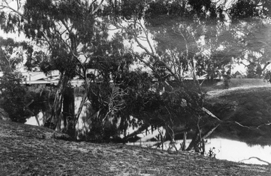
 Stawell Historical Society Inc
Photograph, Campbell’s Bridge over the Wimmera River 1961
Newly built Campbell’s Bridge over the Wimmera River. Built by Redman Bros. Opened in 1961.stawell shire -
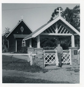 Lakes Entrance Regional Historical Society (operating as Lakes Entrance History Centre & Museum)
Photograph, 1964
Church was licensed and dedicated 29 February 1928.Small format black and white photograph of St John the Evangelist Anglican Church, Cann River, which shows a dark, possibly oil stained timber building with high pitched gable roof, and skillion porch. Entry to property is through lich-gate set of brick pillars. Boy standing at gate Russell Soderlund. Cann River Victoriareligion, buildings -
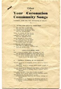 Orbost & District Historical Society
program, 1953
This program was produced by the Snowy River Mail for a community singalong held in Orbost on Tuesday June 2 1953 to celebrate the coronation of Queen Elizabeth 11. In June 1953 , Elizabeth II was crowned Queen of the United Kingdom, Canada, Australia, New Zealand, South Africa, Ceylon (now Sri Lanka), and Pakistan, and became the Head of the Commonwealth. The coronation of Queen Elizabeth II as monarch took place on 2 June 1953. Elizabeth ascended the throne at the age of 25, upon the death of her father, King George VI, on 6 February 1952, and was proclaimed queen by her various privy and executive councils shortly afterwards. The coronation took place more than a year later because of the tradition that holding such a festival is inappropriate during the period of mourning that follows the death of a monarch. This community event was typical of the general feeling of respect and admiration felt by the rural communities towards the British Royal Family. This item reflects the significance of monarchy for Australia and the constitutional history of Australia.The item reflects the interest in the royal family to Australians at this time as well as the general feeling of respect and admiration felt by the rural communities towards the British Royal Family.A white paper program with the words of songs printed in black. There is a rust mark from a metal staple in the top left corner. It is titled "Your Coronation Community Songs".queen-elizabeth-11 royalty community-event-orbost souvenir-program -
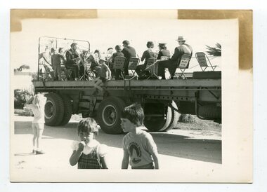 Orbost & District Historical Society
black and white photograph, October 4 1978
From the Snowy River Mail October 4 1978 page 9 - " A MOBILE BAND - Although Orbost Municipal Band participated in Saturday's Primary School workathon, members feet didn't touch the ground. They idi it bthe easywayon the trailer of a truck. The band encouraged walkers with stirring music along the road to Marlo." The first Orbost Brass Band was formed in 1889. Around 1908 the town band split and the Orbost Workers' Band was formed. Eventually the two bands merged in 1913 to reform as the Orbost Municipal Band under conductorship of Charles Spink. The band continued for many years but was later disbanded and again reformed. This was to happen a number of times, the last time being in 1961 and continuing through to the late 1970's. Further info and Ref: In Times Gone By - Deborah Hall This is a pictorial record of the Orbost Municipal Band. The various Orbost bands over the years played a major role in community activities providing entertainment and musical experiences for the many members.A black / white photograph showing a group of uniformed band members sitting on folding chair s on the tray of a large flat bed truck. They are holding musical instruments. A young boy is sitting on the edge of the tray and three other children are standing on the road nearby.on back - information from S.R.M.music orbost-municipal-band entertainment recreation -
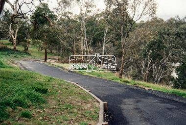
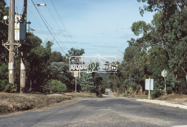
 Eltham District Historical Society Inc
Slide - Photograph, Near the old Lower Plenty Bridge (present day Edward Willis Court), c.Aug. 1990
Part of a presentation, "Roads and Byways of the Shire of Eltham", by Russell Yeoman to the 12 September 1990 Society meeting. Slides shown included copies of old photos and recent images ranging from the suburban streets of Eltham and Montmorency to the mountain roads of Kinglake. In the byways category are views of some iof the Shire's bicycle paths including then recently completed sections of the Main Yarra Trail at Lower Plenty.35mm colour positive transparency (1 of 37) Mount - Agfachrome Agfa CS System black 8 dotsinfrastructure, roads, edward willis court, lower plenty, lower plenty bridge -
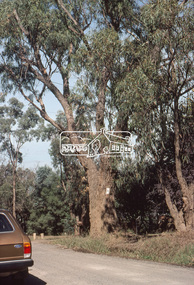
 Eltham District Historical Society Inc
Slide - Photograph, Aerial Photo (c.1987): Main Road, Fitzsimons Lane, Lower Plenty, c.Aug. 1990
Part of a presentation, "Roads and Byways of the Shire of Eltham", by Russell Yeoman to the 12 September 1990 Society meeting. Slides shown included copies of old photos and recent images ranging from the suburban streets of Eltham and Montmorency to the mountain roads of Kinglake. In the byways category are views of some iof the Shire's bicycle paths including then recently completed sections of the Main Yarra Trail at Lower Plenty.35mm colour positive transparency (1 of 37) Mount - Agfachrome Agfa CS System black 8 dotsinfrastructure, roads, aerial photographs, roundabout, bolton steet, bolton steet shops, eltham, fitzsimons lane, lower plenty, main road -
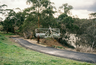
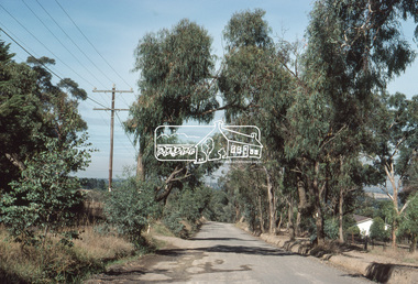
 Eltham District Historical Society Inc
Slide - Photograph, Main Yarra Trail, Lower Plenty, c.Aug. 1990
Part of a presentation, "Roads and Byways of the Shire of Eltham", by Russell Yeoman to the 12 September 1990 Society meeting. Slides shown included copies of old photos and recent images ranging from the suburban streets of Eltham and Montmorency to the mountain roads of Kinglake. In the byways category are views of some iof the Shire's bicycle paths including then recently completed sections of the Main Yarra Trail at Lower Plenty.35mm colour positive transparency (1 of 37) Mount - Agfachrome Agfa CS System black 8 dotsinfrastructure, bonds road, lower plenty, main yarra trail, roads, significant trees -
 Eltham District Historical Society Inc
Slide - Photograph, Main Yarra Trail, Lower Plenty, c.Aug. 1990
Part of a presentation, "Roads and Byways of the Shire of Eltham", by Russell Yeoman to the 12 September 1990 Society meeting. Slides shown included copies of old photos and recent images ranging from the suburban streets of Eltham and Montmorency to the mountain roads of Kinglake. In the byways category are views of some iof the Shire's bicycle paths including then recently completed sections of the Main Yarra Trail at Lower Plenty.35mm colour positive transparency (1 of 37) Mount - Agfachrome Agfa CS System black 8 dotsinfrastructure, bonds road, lower plenty, main yarra trail, roads, yarra river -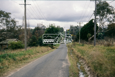
 Eltham District Historical Society Inc
Slide - Photograph, Main Yarra Trail, Lower Plenty, c.Aug. 1990
Part of a presentation, "Roads and Byways of the Shire of Eltham", by Russell Yeoman to the 12 September 1990 Society meeting. Slides shown included copies of old photos and recent images ranging from the suburban streets of Eltham and Montmorency to the mountain roads of Kinglake. In the byways category are views of some iof the Shire's bicycle paths including then recently completed sections of the Main Yarra Trail at Lower Plenty.35mm colour positive transparency (1 of 37) Mount - Agfachrome Agfa CS System black 8 dotsinfrastructure, bonds road, lower plenty, roads -
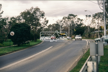 Eltham District Historical Society Inc
Slide - Photograph, Main Road, Lower Plenty, c.Aug. 1990
Part of a presentation, "Roads and Byways of the Shire of Eltham", by Russell Yeoman to the 12 September 1990 Society meeting. Slides shown included copies of old photos and recent images ranging from the suburban streets of Eltham and Montmorency to the mountain roads of Kinglake. In the byways category are views of some iof the Shire's bicycle paths including then recently completed sections of the Main Yarra Trail at Lower Plenty.35mm colour positive transparency (1 of 37) Mount - Agfachrome Agfa CS System black 8 dotsinfrastructure, lower plenty, roads, edward willis court, main road -
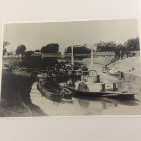 Port of Echuca
Black and white copy of a photograph of steam boats on the Darling River in 1902, Paddle steamers on the Darling River at Wilcannia in 1902, 19/09/1984
Original photograph held by Helen Coulson. A copy is also held by the National Library. 1902 was a drought year. Compare the water levels with that of the same view in P000012. 'P. S Wandering Jew' was built in Victoria in 1866. ( Ref; "The Register of Australian and N.Z Shipping." By C.Earnshaw. Page 136.This photo is significant because it shows the extent of the 1902 drought. It also shows the type of cargo carried in barges, and also the techniques used to unload the cargo. It also show the difference between stern wheelers and side wheeler paddle steamers. It also shows the length nod the height of the bridge at Wilcannia to cope with high and low water levels.A copy of a black and white photograph taken in 1902. It shows 8 paddle steamers and 4 barges under a bridge over the Darling River near Wilcannia in N.S.W. Cargo is being unloaded onto the left bank. Two barges are also tied up on the right bank.Written on the back in pencil " see photo P000012 and P000014.1drought, 1902, darling river, paddle steamers, barges, cargo, river trade, murray darling river basin, irrigation, wilcannia -
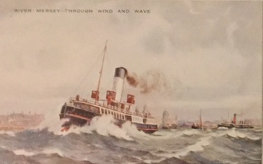 Kew Historical Society Inc
Postcard, Valentine's Series, River Mersey - Through Wind and Wave, c.1928
Collection of thirty-nine postcards donated by Jillian Rigby which had been owned by her grandparents, George and Edith Weir, who from c.1917 lived at 84 Princess Street, Kew. The mostly 'mint' postcards were purchased in Victoria and while travelling overseas. The sole dated postcard is dated from 1929. The postcards are numbered sequentially from 2017.0058.01-39. The remainder of the collection donated by Jill Rigby which was once owned by the Weirs of Broken Hill and Kew consist of costumes, costume accessories, photographs, and documents.The postcards in the Weir collection, especially those purchased on a trip or trips to the mother country, i.e. United Kingdom, represent a representative sample of sites that were considered significant to those Australians undertaking a reverse grand tour by member of the erstwhile colonies. Those postcards which are early views of Melbourne must have been produced commercially for some decades from the early part of the 20th century.River Mersey - Through Wind and Wave. One of a set of three [originally six] 'High Class Postcards of Memories of the Mersey, Beautifully Reproduced in Nature Colours', in their original brown envelope.The postcard was probably purchased by George and Edith Weir on a trip to England and Scotland, circa 1928. postcards, george and edith weir, river mersey, postcards -- england (uk), weir collection -
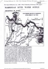 Greensborough Historical Society
Article - Newspaper Clipping (copy), The Argus, Maroondah River water supply 1891, 18/02/1891
An historical account of the development of Melbourne's Maroondah River water supply, including a description of works undertaken in the 1890s.3 p., photocopy of article, downloaded from Trove. Includes transcript in Word document.melbourne water, mmbw, maroondah aqueduct, yan yean reservoir, greensborough, plenty river -
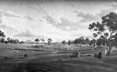 Stawell Historical Society Inc
Photograph, "Woodlands" Homestead near Crowlands on Wimmera River by Johann von Guerard 1869 -- Photo of an Oil Painting
Photograph of Oil on Canvass of Woodlands Homestead near Crowlands on Wimmera River 1869 by Johann von Guerardstawell -
 Stawell Historical Society Inc
Photograph, Bridge over Wimmera River at Glenorchy
Bridge over Wimmera River at Glenorchy. Church in background on right is the former Presbyterian now united church.water -
Lakes Entrance Regional Historical Society (operating as Lakes Entrance History Centre & Museum)
Postcard, Bulmer H D, 1920 c
Postcard lightly tinted of Mitchell River depicting the river at Eagle Point bluff with two men seated on bank, farm house in background Eagle Point VictoriaEagle Point, Mitchell Riverbridges, waterways -
Vision Australia
Audio - Sound recording, Tony Porter, 25th Annual River Run/Walk radio advertisement, 1996
The River Run/Walk event was held by the Association for the Blind (later Vision Australia Foundation) along the banks of the Yarra River. Contestants were invited to run or walk courses of 5 or 10 km, with all funds raised going to AFB. In 1996, the event comprised of 2500 entrants and was sponsored by Priceline. This audio advertisement for the event was made for the 25th anniversary.1 audio file (30 seconds) in CD-DA formatassociation for the blind, fundraising, vision australia foundation -
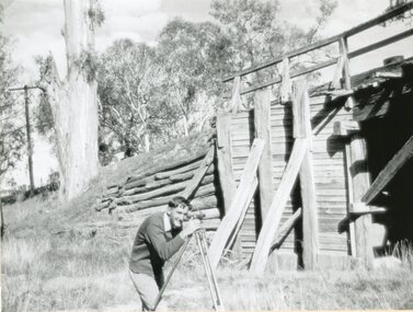 Stawell Historical Society Inc
Photograph, Old Wooden Bridge - over the Wimmera River at Joel Joel being surveyed by Allan Rowe for a new bridge 1951
Old Wooden Bridge - Joel Joel (Wimmera River) 1951 being surveyed by Allan Rowe for new bridgestawell shire -
 Stawell Historical Society Inc
Photograph, Dunmunkle Creek where it originally connected to Wimmera River 2017 -- Coloured
Colour Photo of Dunmunkle Creek originally connected to Wimmera River at this point. Just before the Glenorchy Weir. 2017water -
 Orbost & District Historical Society
black and white photographs, Snowy River Mail, 1960s
These photographs were taken at the annual Orbost Agricultural Show at the Newmerella Showground. They were probably published in the Snowy River Mail newspaper. Some of the Orbost identities pictured include : Russell Crofts, Kevin McDonald, Brian McDonald, Gail & Lee Winchester, Julie & Lisa Drummond, Marion Russell, Sylvia MurrayRod Kleinitz, Rober Morgan, Trevor Perry, Brian Woodlands, anna light, Louella Brunt, Colin Weir, Wendy Pinnock, Raeleen Reed, Margaret Joiner and Jo-anne Mundy. The first meeting to form an Agricultural society in Orbost was convened by the then Orbost Progress Association and held in the Mechanics Hall on Saturday, 10th October 1891. Its first show was held on 3rd March 1904...on a site alongside the Bonang Road where the present Golf Club stands. It is currently held at the Recreation Reserve at Newmerella. (Ref: In Times Gone By-Deborah Hall)These photographs are associated with the Orbost Agricultural Society 's Annual Show which has been a major event in Orbost for over a century. Agricultural shows are an important part of cultural life in small country towns and the Orbost Show is an integral part of Orbost 's agricultural history. Seventeen black / white phootgraphs which were taken at the Orbost Agricultural Show.orbost-agricultural-show -
 Eltham District Historical Society Inc
Slide, Bonds Road, Lower Plenty, Mar. 1981
One of a series of images of road infrastructure focussed on Bonds Road, Lower Plenty, the section connecting Old Eltham Road with Rosehill Road, taken by Eltham Shire Council Planning and Engineering officers. They provide perspective of the changes in housing styles and road development that began sweeping in from the mid 1970s with increasing urbanisation of what was once more outlying suburbs and regions. All images have been identified with GPS35 mm colour positive transparency (1 of 13) Mount - Kodak Kodachrome CardProcessed Mar 1981infrastructure, roads, bonds road, lower plenty, old eltham road -
 Eltham District Historical Society Inc
Slide, Bonds Road, Lower Plenty, Mar. 1981
One of a series of images of road infrastructure focussed on Bonds Road, Lower Plenty, the section connecting Old Eltham Road with Rosehill Road, taken by Eltham Shire Council Planning and Engineering officers. They provide perspective of the changes in housing styles and road development that began sweeping in from the mid 1970s with increasing urbanisation of what was once more outlying suburbs and regions. All images have been identified with GPS35 mm colour positive transparency (1 of 13) Mount - Kodak Kodachrome CardProcessed Mar 1981infrastructure, roads, bonds road, lower plenty -
 Eltham District Historical Society Inc
Slide, Bonds Road, Lower Plenty, Mar. 1981
One of a series of images of road infrastructure focussed on Bonds Road, Lower Plenty, the section connecting Old Eltham Road with Rosehill Road, taken by Eltham Shire Council Planning and Engineering officers. They provide perspective of the changes in housing styles and road development that began sweeping in from the mid 1970s with increasing urbanisation of what was once more outlying suburbs and regions. All images have been identified with GPS35 mm colour positive transparency (1 of 13) Mount - Kodak Kodachrome CardProcessed Mar 1981infrastructure, roads, bonds road, lower plenty