Showing 11716 items matching "r "
-
 Clunes Museum
Book, W R Chambers, Chamber's Encyclopaedia A Dictionary of Universal Knowledge for the People - Volume 3, CHI-ELE, 1874
Illustrated with maps and numerous wood engravingsSticker on front cover "Clunes Mechanic's Institute"encyclopaedia, education -
Clunes Museum
Book, W R Chambers, Chamber's Encyclopaedia A Dictionary of Universal Knowledge for the People - Volume 5 GOO-LAB, 1874
Illustrated with maps and numerous wood engravings Sticker inside cover "Clunes Mechanic's Institute"encyclopaedia, reference material -
Clunes Museum
Book, W R Chambers, Chamber's Encyclopaedia A Dictionary of Universal Knowledge for the People - Volume 6, LAB-NUM, 1874
Illustrated with maps and numerous wood engravingsSticker on front cover "Clunes Mechanic's Institute"encyclopaedia, education -
Clunes Museum
Book, W R Chambers, Chamber's Encyclopaedia A Dictionary of Universal Knowledge for the People - Volume 7, NUM-PUE, 1874
Illustrated with maps and numerous wood engravingsSticker on inside cover "Clunes Mechanic's Institute"encyclopaedia, education -
Clunes Museum
Book, W R Chambers, Chamber's Encyclopaedia A Dictionary of Universal Knowledge for the People - Volume 9, SOU-VIT, 1874
Illustrated with maps and numerous wood engravingsSticker on inside cover "Clunes Mechanic's Institute"encyclopaedia, education -
Clunes Museum
Book, W R Chambers, Chamber's Encyclopaedia A Dictionary of Universal Knowledge for the People - Volume 10, VIT-Z, 1874
Illustrated with maps and numerous wood engravingsSticker on inside cover "Clunes Mechanic's Institute"encyclopaedia, education -
Clunes Museum
Map - CLUNES MAP SHOWING STREETS AND LOT NUMBERS, CHARLES FENTON, 1987
FORMERLY USED FOR DISPLAY IN CLUNES MUSEUM BEFORE RENOVATIONWOOD LOOK FRAMED MAP OF CLUNES, UNDER GLASS. COMPILED BY CHARLES FENTON 1987. CLUNES SHOWING HOUSES, MINES, STREETS AND SURROUNDING ESTATES. LEGEND BOTTOM LEFT.clunes, map -
 Wangaratta RSL Sub Branch
Presentation Box and Medal
Object said to be Macedonian Civil Defence MedalMaroon coloured presentation box containing maroon and blue striped ribbon with three metal bars attached above white stone medal.White stone is engraved front and back with black letters in a circle.macedonia, medal -
Tatura Irrigation & Wartime Camps Museum
Book, Deep Down
Tatura Presbyterian Sunday School 3rd prize awarded to Edgar Mitchell, December 1917. Teacher Mrs Officer.Green hard cover book, decorative scrolling in blue around edge of front cover and spine. Title in gold letters. Sketch of mining scene. 416 pagespresbyterian sunday school prize, tatura presbyterian church, edgar mitchell, mrs officer -
Tatura Irrigation & Wartime Camps Museum
Document, Royal Commission on Water Supply - Minutes of Evidence, 1896
34 Pages of evidence taken at the 1896 Royal Commission on Water Supply. Some of the hearing was held at Tatura. A4 Photocopy -
Tatura Irrigation & Wartime Camps Museum
Photograph, N. R. McGeehan photographer, Catholic Ball 1933, 1933
Original photograph on post card, of Catholic Ball, Tatura, 1933. Debs and partners presented to Mr and Mrs T. Hastie. Many local identities. Misses A. Hunter, C. Mulchay, two unknown.Black and white photograph of Catholic Ball, Tatura, 1933. Note Victory Hall very gaily decorated with streamers. Interior.on back: Catholic Ball Tatura 1933. Names of Debs and partnerscatholic ball 1933 -
Tatura Irrigation & Wartime Camps Museum
Photograph, N. R. McGeehan photographer, Byrneside Hall, 1934
Original photograph of plain and fancy dress held in Byrneside Hall, 1934. Belonging to Teresa Bradley (Mrs M. Hogan). Many Tatura present and former residents pictured.black and white photograph of ball in Byrneside Hall 1934.plain and fancy ball. Burnside 1934. on back: Burnside 1934 Teresa Bradleybyrneside hall -
Tatura Irrigation & Wartime Camps Museum
Photograph - original, N. R. McGeehan photographer, Tatura Coursing Club 1933, 1933
Original photograph of Committee and stewards of Tatura Coursing Club 1933. There has been a Coursing Club in Tatura since early 1900's.Original photograph of members of Tatura Coursing Club 1933.on back: Committee and stewards Tatura Coursing Club 1933 -
Tatura Irrigation & Wartime Camps Museum
Photograph - original, N. R. McGeehan photographer, Plumpton Tatura Coursing Club 1933, 1933
Original photograph of crowd at opening of Plumpton Tatura Coursing Club 1930.Original photograph of members of crowd of men, women and children at opening of Plumpton Coursing Club at Tatura 1933. Copy L0601on back: Opening of the Plumpton Tatura 1933. Shire of Rodney -
Tatura Irrigation & Wartime Camps Museum
Book, Father R Burton-Clay, Solving the mystery, 1978
The birth of Catholicism in TaturaCardboard cover, yellow, with green printing. 48 pages. Pages stapled togetherInside cover - "Presented to Tatura and District Historical Society by Mrs J Forster, 22/08/84" -
Tatura Irrigation & Wartime Camps Museum
Photograph - original, N. R. McGeehan photographer, Cross Silver Wedding 1933, 1933 original
Original photograph of group of people celebrating the Cross silver wedding. 5 August 1933. Jack Welpdale (bottom right hand corner), Bertha (wife) next in coat with fur on collar and cuffs. Former residents of "Reserve" Tatura.Black and white photograph of the Cross silver wedding 1933.on back: Jack and Bertha Whelpdale, identified. -
Tatura Irrigation & Wartime Camps Museum
Book, The Australian Countryside in Pictures
Hard cover book. Red covers - embossed illustration of man with rural products on front. "The Australian countryside in pictures" in silver on spine. 240 pages. Coloured and B/W pictures.."The Australian countryside in pictures" on spine.e mitchell -
 Tatura Irrigation & Wartime Camps Museum
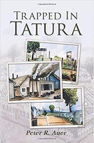
Book, Trapped in Tatura, 2016
Historical fiction based on the Auer family's experiences during W.W 2 at Tatura camp 3. Dominance of Nazism and deprivation of freedom imposed on all internees.Rectangle shaped, Cover has three water coloured sketches of Camp 3 Tatura. Book also has B/W sketches of camp. 164 pages Book dedicated to author's grandfather, Rudolf Auer Sr. tatura camp -
Tatura Irrigation & Wartime Camps Museum
Book, Into History, 1989
Follow up to first edition. Published in April 1988. Contains data collected December 1988 to April 1989.Glossy yellow, soft cardboard cover. Green lettering. second editioninto history -
 Anglesea and District Historical Society
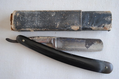
Razor & Case, Estimated pre 1965 (probably early 20th Century)
Straight razor in case. (00955/1). Blade of razor made by Cadman & Sons, Sheffield. Blade folds away into plastic handle. Case carries Crown & Sword branding [note: this is a different company altogeher] (00955/2).[on case] Crown & Sword Razor / Guaranteed [on blade] Made in England expressly foir G Peart / Tobacconist / Mildura [on blade handle] Cadman & Sons, Sheffield, England / logo BENGALL. crown & sword - g peart, mildura, cadman & sons, sheffield -
 Wheen Bee Foundation
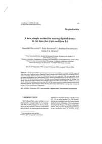
Publication, Polaczek, B., Neumann, P., Schricker, B. & Moritz, R. F. A, A new, simple method for rearing diploid drones in the honeybee (Apis mellifera L.) (Polaczek, B. et al), Les Ulis Cedex, 2000, 2000
-
![Publication, Greco, M., Spooner-Hart, R., Beattie, A. & Holford, P, Application and management of Australian stingless bees (Greco, M. et al.), Sydney, [nd]](/media/collectors/52ae888f2162ef0b08d63076/items/5339f7cd2162ef13b81b6636/item-media/533a0d962162ef13b81c7217/item-fit-380x285.jpg) Wheen Bee Foundation
Wheen Bee FoundationPublication, Greco, M., Spooner-Hart, R., Beattie, A. & Holford, P, Application and management of Australian stingless bees (Greco, M. et al.), Sydney, [nd]
-
 Wheen Bee Foundation
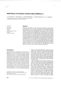
Publication, Kraus, F. B., Neumann, P., Scharpenberg, H., van Praagh, J. & Moritz, R. F. A, Male fitness of honeybee colonies (Apis mellifera L.) (Kraus, F. B. et al.), New York, 2003, 2003
-
 Wheen Bee Foundation
Publication, Schlüns, H., Schlüns, E. A., van Praagh, J. & Moritz, R. F. A, Sperm numbers in drone honeybees (Apis mellifera) depend on body size (Schlüns, H. et al.), Les Ulis Cedex, 2003, 2003
-
 Chelsea & District Historical Society Inc
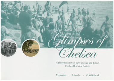
Book, G.Whitehead, Glimpses of Chelsea, 2007
Photos and descriptions of historical buildings Chelsea District Historical Society is fortunate to have many photos that have been donated and collated over the last fifty years. In the early years our beachside suburb was popular with groups and families. Camping & holidaying in guest houses or privately rented houses. This book includes photographs of local people, beaches, churches, clubs, sports, hotels, railways, industry, hospitals and halls, and many other pictures of local scenes. A unique history of the District of Chelsea. Photographs show the beginnings and how the Chelsea district was developed. Various Sporting clubs and groups, businesses, buildings, streets and early European settlers and others. Large soft cover book A pictorial history of early Chelsea & District first printed 2007aspendale, carrum, bonbeach, edithvale, chelsea -
 Wangaratta RSL Sub Branch
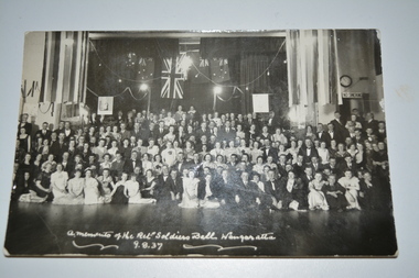
Photograph, Ret. Soldiers Ball Wangaratta 9.8.37, 1937
Returned Soldier's Ball held in Wangaratta on 9th August 1937 Captain Mulder and Jim Boyd were floor stewards. A special set of four couples in full regimental dress danced the Quadrilles and other set dances.First Military Ball held in Wangaratta and due to its success it was decided to make it an annual event. Black and white unframed photograph of large group of men and women in front of stage with flags in background mounted on brown cardboardA momento of the Ret. Soldiers Ball Wangaratta 9.8.371937, wangaratta, returned soldier's ball -
 Uniting Church Archives - Synod of Victoria
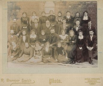
Photograph, R. Dermer Smith, California Gully, Eaglehawk Methodist Church. Sunday School Teachers and Officers c1900, c1900
Sepia photograph with a card mount of a group in front of the exterior of the Sunday School.California Gully, Eaglehawk Methodist Church. Sunday School Teachers and Officerseaglehawk methodist church sunday school -
 Uniting Church Archives - Synod of Victoria
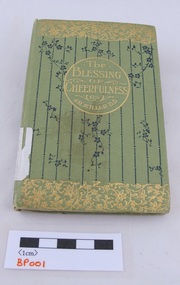
Book, Miller, J. R., D.D, The blessing of cheerfulness, n.d
“We are set in this world to be happy. We should not falter in our great task of happiness, nor move ever among our fellows with shadows on our face when we ought to have sunlight. “We have a mission to others — to add to their cheer. This we cannot do unless we have first learned the lesson of cheerfulness ourselves. We cannot teach what we do not know. We cannot give what we do not have. “In this little book a lesson is set for you, my reader. It may seem a hard lesson to learn; nevertheless, it is one you want to learn, and one you can learn, if you will surrender your life wholly to the great Teacher. – From the Preface by James Russell MillerPale green cover with gold embossed text and floral borders. Black floral decoration on the front cover. 62 pages. The book has a dedication inside and is signed by the members of the band.non-fiction“We are set in this world to be happy. We should not falter in our great task of happiness, nor move ever among our fellows with shadows on our face when we ought to have sunlight. “We have a mission to others — to add to their cheer. This we cannot do unless we have first learned the lesson of cheerfulness ourselves. We cannot teach what we do not know. We cannot give what we do not have. “In this little book a lesson is set for you, my reader. It may seem a hard lesson to learn; nevertheless, it is one you want to learn, and one you can learn, if you will surrender your life wholly to the great Teacher. – From the Preface by James Russell Millere. sprott, sydney road brunswick methodist church -
 Uniting Church Archives - Synod of Victoria
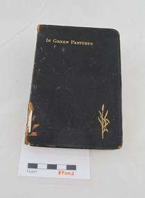
Book, Miller, J. R, In green pastures: daily readings for every day of the year, c1904
Soft covered black leather book leather book with gilt embossing on the cover and spine edges. 243 pages. Inscription on the title page. non-fictione. sprott, methodist sabbath school sydney road brunswick -
 Robin Boyd Foundation
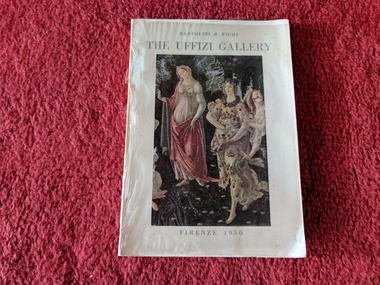
Book, R. Bartolini and E. Fiumi, The Uffizi Gallery, 1950
Softcover w/ clear plastic coverwalsh st library