Showing 176628 items
matching streets
-
 Linton and District Historical Society Inc
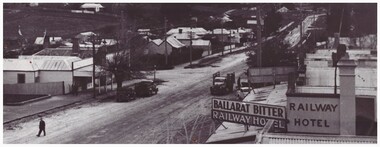
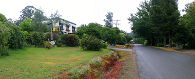
Photograph, Sussex Street, Linton, circa 1940, circa 1940
Date photograph taken is unknown, presence of electricity poles in street suggests it was taken after 1939.Black and white photograph of Sussex Street, Linton. View from above, roof of Railway Hotel on right in foreground, then view of shops and houses along west of street, looking to the north-west.On back of photograph: "Linton - probably c1930s".sussex street linton, railway hotel linton, "ballarat bitter" -
 Ringwood and District Historical Society
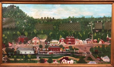
Painting, Olive Vass, "Ringwood Scene 1920" - oil on canvas by Olive Vass, 1920
Framed oil painting on canvas panel depicting railway station and view looking north across main street of Ringwood 1920.Bottom of frame marked "Ringwood 1920". Written on back - "Early Ringwood about 1920" and "Mrs. Olive Vass 27 James Street Ringwood 8701528". -
 Victorian Interpretive Projects Inc.
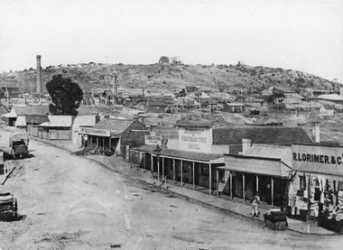
Photograph - Black and White, Ballarat, c1854
The town you see had over 50,000 people. Bridge Street on the left is well established. The crude pans and cradles of the early “diggers’ were already giving way to steam power and the deep shafts of the “miners”. Money and machinery were needed to get to the deeper leads, and the smoke stacks of the great company mines can be seen across the photo.Four black and white photographs placed together to make a panorama of Ballarat looking towards Mt Warrenheip. On the left the chimney and gasometer indicate the corner of Dana Street and Albert Street. This is now the Ballarat Law Courts. The photograph is behind glass in a black frame. These four photographs were taken from the slope of the Ballarat School of Mines where the Uniting Church now stands. When joined they give a panoramic view of one of the world’s richest alluvial goldfields. The Waterloo Mine was one of the first deep shafts and was sunk at the foot of the Dana Street hill. Its tailings are seen in the second photo from left. The following was typed and placed with the framed image. Ballarat Circa 1858 This is the most significant of the photographs of early Ballarat. The photographer stood on the slope near S.M.B. where the Wesley Church now stands and took four pictures. When joined them have this panoramic view of one of the world's richest alluvial goldfields. Seven years earlier this landscape was empty. The town you see had over 50,000 people. Bridge Street on the left is well established the Ballarat gas Company stands on the same place as today. The crude pans and cradles of the early "diggers" were already giving way to steam power and the deep shafts of the :"miners". Money and machinery were needed to get to the deeper leads, and the smoke stacks of the great company mines can be seen across the photo. The Waterloo mines was one of the first deep shafts and was sunk at the foot of the Dana Street hill. Its tailings are seen in the second photo from the left. ballarat, ballarat townscape, panorama, waterloo mine -
Lakes Entrance Regional Historical Society (operating as Lakes Entrance History Centre & Museum)
Photograph, Lakes Post Newspaper, 7/10/1991 12:00:00 AM
Another black and white photograph taken of final stages of Porters Lakes cycling tour looking toward Mourlyan Street corner number 04027.1 size 18 x 22.5 cmBlack and white photograph taken at the final stage of Patties Lakes Cycling Tour organised by Frank Daly, shows cyclists approaching and crossing the finish line with many bystanders at Stock Street and Maurilyan Street intersections, Roadknight Street Lakes Entrance Victoriasports -
Glenelg Shire Council Cultural Collection
Photograph - Sheet of 12 contact prints - Various historic Portland buildings and Landmarks, c. 1970
Sheet of 12 contact prints of rephotographed photographs. Measurements (a) (e)-(h) (j-i)(b) 3.7 x 55 x 3.7 Framed 5.2 x 44.5 x 4 (a) Looking south across beach at Dutton Way (b) S.S. 'Eumeralla' (c) Construction of railway pier (d) Jackass Fern Gully (e) 'Kingsley' (f) Portland Show (g) North side Julia Street looking west Bank of Australiasia (h) Henty Street looking east from Percy Street (i) Old Post Office (j) All Saints Catholic Church (k) View from Henty Street - old Town Hall (l) Opening 3rd BathsFront: (a) 'Dutton Way 1900 (b) 'S.S. Eumeralla' (c) Construction of Railway Pier (f) Portland Show (h) Henty Street, Portland (i) (B) -
 Marysville & District Historical Society
Photograph (Item) - Colour photograph, Travel Victoria, 2006
A colour photograph of Murchison Street in Marysville in Victoria.A colour photograph of Murchison Street in Marysville in Victoria. Photograph shows a view of The Corner Cupboard Cafe which, along with most of the buildings along Murchison Street, was destroyed in the 2009 Black Saturday bushfires.murchison street, the corner cupboard cafe, marysville, victoria, photograph, 2009 black saturday bushfires -
 Marysville & District Historical Society
Photograph (Item) - Colour photograph, Unknown
A colour photograph of Darwin Street in Marysville in Victoria.A colour photograph of Darwin Street in Marysville in Victoria. Darwin Street was named after Charles Robert Darwin. Charles Robert Darwin was an English naturalist, geologist, and biologist, widely known for his contributions to evolutionary biology. His theory that all species of life have descended from a common ancestor is now generally accepted and considered a fundamental concept in science. In a joint publication with Alfred Russel Wallace, he introduced his scientific theory that this branching pattern of evolution resulted from a process he called natural selection, in which the struggle for existence has a similar effect to the artificial selection involved in selective breeding. Charles Darwin has been described as one of the most influential figures in human history and is buried in Westminster Abbey. charles robert darwin, darwin street, marysville, victoria, the country cupboard cafe, the marysville museum, photograph -
 Marysville & District Historical Society
Photograph (Item) - Colour photograph, Unknown
A colour photograph of Darwin Street in Marysville in Victoria.A colour photograph of the Scenic Bed and Breakfast in Darwin Street in Marysville in Victoria. The Scenic Bed and Breakfast, along with all the guest houses in Marysville, was destroyed in the 2009 Black Saturday bushfires. Darwin Street was named after Charles Robert Darwin. Charles Robert Darwin was an English naturalist, geologist, and biologist, widely known for his contributions to evolutionary biology. His theory that all species of life have descended from a common ancestor is now generally accepted and considered a fundamental concept in science. In a joint publication with Alfred Russel Wallace, he introduced his scientific theory that this branching pattern of evolution resulted from a process he called natural selection, in which the struggle for existence has a similar effect to the artificial selection involved in selective breeding. Charles Darwin has been described as one of the most influential figures in human history and is buried in Westminster Abbey. charles robert darwin, darwin street, marysville, victoria, scenic b&b, 2009 black saturday bushfires, photograph -
Stawell Historical Society Inc
Photograph, Commonwealth Federation Monument in Main Street Stawell 1904, 27 December 1904
Commonwealth Memorial Lower Main Street StawellErected in Honor of First ParlimentPostcard with Stamp of Commonwealth Monument Main Street. Boys Sitting around BaseFront- Souvenir From Stawell (Victoria) A Picard - Stawell) Commonwealth Monument. Rear - Miss K A Simpson Young House Parkside S.A.stawell -
 Hume City Civic Collection
Manual - Street Directory, Morgan's Official Street Directory of Melbourne and Suburbs, 1980's
This street directory of Melbourne and Suburbs was the 52nd edition published by Val Morgan. It is printed with a new map format.A Morgan's street directory of Melbourne and Suburbs without a front cover.morgan, val and co., melbourne, directories, street directories, george evans collection -
 Stawell Historical Society Inc
Photograph, Streetscape of South side of Upper Main Street Reefs Stawell looking East from around Patrick Street corner with Big Hill Mining in background c 1867
Upper Main Street east of Patrick street, looking East c 1867 with Big Hill Mining in Background. J McGee's Shamrock Hotel. Jennings Western Turf Hotel. R Lorimer & Co. Photo c 1867 McGees Shamrock Hotel centre. R. Williams Dining Rooms, Jennings's Western Turf Hotel. Situated in upper Main Street (Opposite Monaghan's Estate Office) Mr. George Jennings was proprietor until the late 1860's when he went to live at "Mayo Park" Lubek. The Hotel had Various owners until it was delicensed in 1909 and became a boarding house. It was demolished in 1921. R. Lorimer & Co general Store near corner of Patrick Street.Streetscape of South Side of Main Street East of Patrick Street. Two wagons in street. Showing J. McGees Shamrock Hotel, R Williams Dining Rooms, Jennings's Western Turf Hotel and R. Lorimer & Co. Mine Engine Chimney is on left of photo. Big Hill in Background with Waterloo Reef Company Whim at centre.stawell streetscape -
 Uniting Church Archives - Synod of Victoria
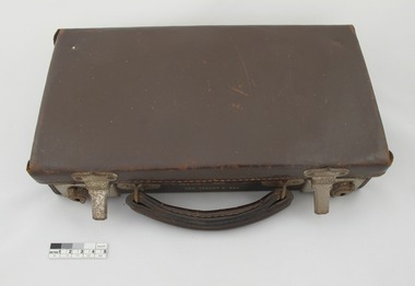
Travelling Communion Set
Rev Stuart Rea was at Central Mission, Lygon Street, Carlton from 1938-1942.G073.1 Small brown leather suitcase-style case with two lock catches and a handle. The case has a stained wood insert containing G073.2 - G073.9 eight glass communion glasses. The case is lined with navy blue grosgrain fabric and has a small leather label in the lid. Secured in the lid with leather straps is a round silver box, G073.10, with an etched lid, G073.11. G073.12 Silver cylindrical flask with an etched design on the front with G073.13 silver screw top, cork lined, lid. G073.14 Circular white lace mat in a separate section of the box. G073.15 Stained and varnished wooden stand to hold 12 glasses. G073.1 has a name stamped between the handles and a dedication inside."REV STUART G. REA" "THE GIFT OF LYGON STREET METHODIST CHURCH"lygon street methodist church, rev stuart g rea -
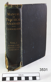 Flagstaff Hill Maritime Museum and Village
Book, Young J. Pentland, Manual of Practical Anatomy, Vol. I. Upper Limb, Lower Limb, Abdomen, 1893
This book was used by Dr Angus when studying at Adelaide University. It was donated to Flagstaff Hill Maritime Village by the family of Doctor William Roy Angus, Surgeon and Oculist. It is part of the “W.R. Angus Collection” that includes historical medical equipment, surgical instruments and material once belonging to Dr Edward Ryan and Dr Thomas Francis Ryan, (both of Nhill, Victoria) as well as Dr Angus’ own belongings. The Collection’s history spans the medical practices of the two Doctors Ryan, from 1885-1926 plus that of Dr Angus, up until 1969. ABOUT THE “W.R.ANGUS COLLECTION” Doctor William Roy Angus M.B., B.S., Adel., 1923, F.R.C.S. Edin.,1928 (also known as Dr Roy Angus) was born in Murrumbeena, Victoria in 1901 and lived until 1970. He qualified as a doctor in 1923 at University of Adelaide, was Resident Medical Officer at the Royal Adelaide Hospital in 1924 and for a period was house surgeon to Sir (then Mr.) Henry Simpson Newland. Dr Angus was briefly an Assistant to Dr Riddell of Kapunda, then commenced private practice at Curramulka, Yorke Peninsula, SA, where he was physician, surgeon and chemist. In 1926, he was appointed as new Medical Assistant to Dr Thomas Francis Ryan (T.F. Ryan, or Tom), in Nhill, Victoria, where his experiences included radiology and pharmacy. In 1927 he was Acting House Surgeon in Dr Tom Ryan’s absence. Dr Angus had become engaged to Gladys Forsyth and they decided he would take time to further his studies overseas in the UK in 1927. He studied at London University College Hospital and at Edinburgh Royal Infirmary and in 1928, was awarded FRCS (Fellow from the Royal College of Surgeons), Edinburgh. He worked his passage back to Australia as a Ship’s Surgeon on the on the Australian Commonwealth Line’s SS Largs Bay. Dr Angus married Gladys in 1929, in Ballarat. (They went on to have one son (Graham 1932, born in SA) and two daughters (Helen (died 12/07/1996) and Berenice (Berry), both born at Mira, Nhill ) Dr Angus was a ‘flying doctor’ for the A.I.M. (Australian Inland Ministry) Aerial Medical Service in 1928 . The organisation began in South Australia through the Presbyterian Church in that year, with its first station being in the remote town of Oodnadatta, where Dr Angus was stationed. He was locum tenens there on North-South Railway at 21 Mile Camp. He took up this ‘flying doctor’ position in response to a call from Dr John Flynn; the organisation was later known as the Flying Doctor Service, then the Royal Flying Doctor Service. A lot of his work during this time involved dental surgery also. Between 1928-1932 he was surgeon at the Curramulka Hospital, Yorke Peninsula, South Australia. In 1933 Dr Angus returned to Nhill where he’d previously worked as Medical Assistant and purchased a share of the Nelson Street practice and Mira hospital from Dr Les Middleton one of the Middleton Brothers, the current owners of what was once Dr Tom Ryan’s practice. Dr L Middleton was House Surgeon to the Nhill Hospital 1926-1933, when he resigned. [Dr Tom Ryan’s practice had originally belonged to his older brother Dr Edward Ryan, who came to Nhill in 1885. Dr Edward saw patients at his rooms, firstly in Victoria Street and in 1886 in Nelson Street, until 1901. The Nelson Street practice also had a 2 bed ward, called Mira Private Hospital ). Dr Edward Ryan was House Surgeon at the Nhill Hospital 1884-1902 . He also had occasions where he successfully performed veterinary surgery for the local farmers too. Dr Tom Ryan then purchased the practice from his brother in 1901. Both Dr Edward and Dr Tom Ryan work as surgeons included eye surgery. Dr Tom Ryan performed many of his operations in the Mira private hospital on his premises. He too was House Surgeon at the Nhill Hospital 1902-1926. Dr Tom Ryan had one of the only two pieces of radiology equipment in Victoria during his practicing years – The Royal Melbourne Hospital had the other one. Over the years Dr Tom Ryan gradually set up what was effectively a training school for country general-practitioner-surgeons. Each patient was carefully examined, including using the X-ray machine, and any surgery was discussed and planned with Dr Ryan’s assistants several days in advance. Dr Angus gained experience in using the X-ray machine there during his time as assistant to Dr Ryan. Dr Tom Ryan moved from Nhill in 1926. He became a Fellow of the Royal Australasian College of Surgeons in 1927, soon after its formation, a rare accolade for a doctor outside any of the major cities. He remained a bachelor and died suddenly on 7th Dec 1955, aged 91, at his home in Ararat. Scholarships and prizes are still awarded to medical students in the honour of Dr T.F. Ryan and his father, Dr Michael Ryan, and brother, John Patrick Ryan. ] When Dr Angus bought into the Nelson Street premises in Nhill he was also appointed as the Nhill Hospital’s Honorary House Surgeon 1933-1938. His practitioner’s plate from his Nhill surgery states “HOURS Daily, except Tuesdays, Fridays and Saturday afternoons, 9-10am, 2-4pm, 7-8pm. Sundays by appointment”. This plate is now mounted on the doorway to the Port Medical Office at Flagstaff Hill Maritime Village, Warrnambool. Dr Edward Ryan and Dr Tom Ryan had an extensive collection of historical medical equipment and materials spanning 1884-1926 and when Dr Angus took up practice in their old premises he obtained this collection, a large part of which is now on display at the Port Medical Office at Flagstaff Hill Maritime Village in Warrnambool. During his time in Nhill Dr Angus was involved in the merging of the Mira Hospital and Nhill Public Hospital into one public hospital and the property titles passed on to Nhill Hospital in 1939. In 1939 Dr Angus and his family moved to Warrnambool where he purchased “Birchwood,” the 1852 home and medical practice of Dr John Hunter Henderson, at 214 Koroit Street. (This property was sold in1965 to the State Government and is now the site of the Warrnambool Police Station. ). The Angus family was able to afford gardeners, cooks and maids; their home was a popular place for visiting dignitaries to stay whilst visiting Warrnambool. Dr Angus had his own silk worm farm at home in a Mulberry tree. His young daughter used his centrifuge for spinning the silk. Dr Angus was appointed on a part-time basis as Port Medical Officer (Health Officer) in Warrnambool and held this position until the 1940’s when the government no longer required the service of a Port Medical Officer in Warrnambool; he was thus Warrnambool’s last serving Port Medical Officer. (The duties of a Port Medical Officer were outlined by the Colonial Secretary on 21st June, 1839 under the terms of the Quarantine Act. Masters of immigrant ships arriving in port reported incidents of diseases, illness and death and the Port Medical Officer made a decision on whether the ship required Quarantine and for how long, in this way preventing contagious illness from spreading from new immigrants to the residents already in the colony.) Dr Angus was a member of the Australian Medical Association, for 35 years and surgeon at the Warrnambool Base Hospital 1939-1942, He served as a Surgeon Captain during WWII1942-45, in Ballarat, Victoria, and in Bonegilla, N.S.W., completing his service just before the end of the war due to suffering from a heart attack. During his convalescence he carved an intricate and ‘most artistic’ chess set from the material that dentures were made from. He then studied ophthalmology at the Royal Melbourne Eye and Ear Hospital and created cosmetically superior artificial eyes by pioneering using the intrascleral cartilage. Angus received accolades from the Ophthalmological Society of Australasia for this work. He returned to Warrnambool to commence practice as an ophthalmologist, pioneering in artificial eye improvements. He was Honorary Consultant Ophthalmologist to Warrnambool Base Hospital for 31 years. He made monthly visits to Portland as a visiting surgeon, to perform eye surgery. He represented the Victorian South-West subdivision of the Australian Medical Association as its secretary between 1949 and 1956 and as chairman from 1956 to 1958. In 1968 Dr Angus was elected member of Spain’s Barraquer Institute of Barcelona after his research work in Intrasclearal cartilage grafting, becoming one of the few Australian ophthalmologists to receive this honour, and in the following year presented his final paper on Living Intrasclearal Cartilage Implants at the Inaugural Meeting of the Australian College of Ophthalmologists in Melbourne In his personal life Dr Angus was a Presbyterian and treated Sunday as a Sabbath, a day of rest. He would visit 3 or 4 country patients on a Sunday, taking his children along ‘for the ride’ and to visit with him. Sunday evenings he would play the pianola and sing Scottish songs to his family. One of Dr Angus’ patients was Margaret MacKenzie, author of a book on local shipwrecks that she’d seen as an eye witness from the late 1880’s in Peterborough, Victoria. In the early 1950’s Dr Angus, painted a picture of a shipwreck for the cover jacket of Margaret’s book, Shipwrecks and More Shipwrecks. She was blind in later life and her daughter wrote the actual book for her. Dr Angus and his wife Gladys were very involved in Warrnambool’s society with a strong interest in civic affairs. Their interests included organisations such as Red Cross, Rostrum, Warrnambool and District Historical Society (founding members), Wine and Food Society, Steering Committee for Tertiary Education in Warrnambool, Local National Trust, Good Neighbour Council, Housing Commission Advisory Board, United Services Institute, Legion of Ex-Servicemen, Olympic Pool Committee, Food for Britain Organisation, Warrnambool Hospital, Anti-Cancer Council, Boys’ Club, Charitable Council, National Fitness Council and Air Raid Precautions Group. He was also a member of the Steam Preservation Society and derived much pleasure from a steam traction engine on his farm. He had an interest in people and the community He and his wife Gladys were both involved in the creation of Flagstaff Hill, including the layout of the gardens. After his death (28th March 1970) his family requested his practitioner’s plate, medical instruments and some personal belongings be displayed in the Port Medical Office surgery at Flagstaff Hill Maritime Village, and be called the “W. R. Angus Collection”. The W.R. Angus Collection is significant for still being located at the site it is connected with, Doctor Angus being the last Port Medical Officer in Warrnambool. The collection of medical instruments and other equipment is culturally significant, being an historical example of medicine from late 19th to mid-20th century. Dr Angus assisted Dr Tom Ryan, a pioneer in the use of X-rays and in ocular surgery. Manual of Practical Anatomy, Vol. I. Upper Limb, Lower Limb, Abdomen, D.J. Cunningham, Pub 1893,Young J. Pentland, Edingurgh and London. Label "W.R. Angus/309 Koroit Street, Warrnambool, Victoria, 3280". Name in pencil looks like “A S Cobbledick” (W.R. Angus Collection)Label "W.R. Angus/309 Koroit Street, Warrnambool, Victoria, 3280". Name in pencil looks like “A S Cobbledick” flagstaff hill, warrnambool, shipwrecked-coast, flagstaff-hill, flagstaff-hill-maritime-museum, maritime-museum, shipwreck-coast, flagstaff-hill-maritime-village, book, medical book, manual of practical anatomy, published 1883, medical text book, dr w r angus, dr t.f. ryan, medical history, medical treatment, medical education, young j. pentland -
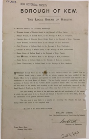 Kew Historical Society Inc
Document, Holland Loxton, Notification to the Residents of Derrick Street by the Local Board of Health, 1885, 1885
Streets and drains were the basic infrastructure problems for Kew in the 1880s. Decent streets and drains were fundamental to the quality of life of the residents. Without drainage, streets became muddy, boggy and sometimes impassable. Pools and puddles of stagnant water became smelly. The run off water, mixed with human and animal wastes, because there was no sewerage, became a health hazard. Streets and drains then became what were known as 'a nuisance'. Kew suffered from bouts of typhoid fever during the 1880s. Derrick Street was a private street on the margin of the business district of Kew and a well-used thoroughfare. We hear first about Derrick Street when the ratepayers applied to Council to have the street 'taken over' in January 1881. The Council agreed, after much debate, but ratepayers had to pay half the costs. The argument of the majority of the Council was that there was an established policy that ratepayers of private streets either had to hand over the street fully-formed or pay half the costs if Council did the work. It was felt that to make an exception for Derrick Street would create a precedent for ratepayers of other private streets. On the other hand the ratepayers, and a minority of Council, believed that there were extenuating circumstances in the case of Derrick Street. They believed that the costing by the Borough Surveyor was excessive. They felt the Council was partly responsible for the state of the street due to a channel on Bulleen Road, which deposited sand in the street. The Council had also put in some kerbing at the entrance to the street. Finally, the ratepayers believed that the street had become an important and convenient thoroughfare in Kew, and thus should be an exception to the policy on private streets. In the end a decision was delayed to allow the ratepayers to drain and form the street themselves. And there the matter stood till September 1882, when Miss Reilly complained about rubbish on a block of land in Derrick Street. So, in October 1882 the Council agreed to take over and form the street with the ratepayers paying half the costs. The ratepayers did not want to pay, so the argument continued in Council into 1883. There was a standoff for a further 18 months, until the problem could no longer be ignored. In October 1884 the Inspector of Nuisances and the Health Officer reported that Derrick Street was a health hazard as there was no drainage outlet for waste water. These reports changed the status of the problem of Derrick Street. It became an issue of public health, and thus the Council, acting as the Local Board of Health, had power to prepare plans and order the ratepayers to drain the street and pay all the costs, or let the Council do the work and charge ratepayers half the costs of the works. By April 1885, the time for ratepayers to complete the works themselves had expired, so the Council proceeded with the work and required ratepayers to pay for their share of the costs. All ratepayers had paid by the end of April except Mr Whiddycombe, who refused to pay. Mr Whiddycombe was warned to pay in October 1885. Legal action was taken against him in November. The Council lost the case on technical grounds. The Council, acting as the Local Board of Health, relaunched the legal action and won. The last we hear of Derrick Street is that seven day’s notice was given to Derrick Street ratepayers to pay for the drainage works in May 1887. We presume that Mr Whiddycombe paid. (Research: Andrew Frost)Rare and historic publication issued by the Board of Health in the Borough of Kew in 1885 to residents of Derrick street regarding the need for proper drainage for the purpose of improving public health.Printed formal notice sent by the Board of Health of the Borough of Kew to landowners in Derrick Street, Kew. The notice advised the owners that they were required to form and drain the street according to the levels and specifications approved by the Board. The letter was sent on January 23rd 1885, and signed by the Inspector of Nuisances.borough of kew -- greater melbourne (vic.), council notices -- public health, derrick street -- kew (vic.) -
Port Melbourne Historical & Preservation Society
Plan, B A Carter, Land Plan Primary School 1427 Port Melb, c. 1975
The design for extensive planting and landscaping of Nott Street Primary School, Port MelbournePlan of Landscape design for Nott Street Primary School, Port Melbourne.education - primary schools, nott street primary school -
Stawell Historical Society Inc
Photograph, Stawell Police Station in Patrick Street 1991-92
New Stawell Police Station Building commenced March 1991 Patrick StreetColour photograph of New Police Station in Patrick Street March 1991stawell -
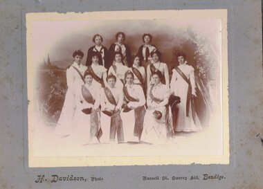 Bendigo Historical Society Inc.
Photograph - GROUP OF WOMEN, EMPIRE DAY DRESS, 1910?
Sepia photograph on grey board. Ten females in long white dresses with long fringed sashes embossed with 'cead mile failte'. All have small Irish harps in hair and carry small black bags. Back row - three young girls with white tops and dark capes. Inscriptions: in image - on sashes 'cead mille failte'. Printed on board at bottom 'H Davidson, Photo, Russell Street, Quarry Hill, Bendigo'. On back - hand written in pencil. 'Empire Fair', 'Ireland', 'Mechanic's Institute'.H Davidson, Russell Street, Quarry Hillperson, group, women -
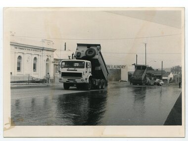 Orbost & District Historical Society
black and white photographs, 1984
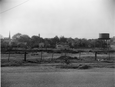
These photographs were taken in the main street of Orbost looking south along Nicholson Street. Nicholson Street was remade in 1984 with new kerb alignments, the introduction of red brick paving and the planting of oak trees. This has since been changed.These photographs are pictorial records of construction in the main street of Orbost.Two black / white photographs of roadworks. 3278.1 is of two tip trucks on a newly sealed road. The commonwealth Bank is on the left and in the background is a sign to "COIN LAUNDRY'. 3278.2 is of three men at the edge of the road, backs to the camera.3278.1 - on back - "Resealing of Nicholson Street, Orbost, 1984" 3278.2 - on back - "Peter Dreverman in middle"orbost-nicholson-street construction-nicholson-street roadworks streetscape -
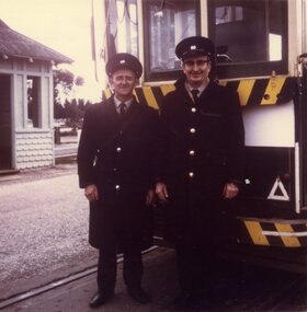 Ballarat Tramway Museum
Photograph - Colour Print, Lilian Butler, 10/08/1971 12:00:00 AM
Possibly has a strong association with SEC Ballarat tram crews.Colour print of driver or motorman - M Cahil (48) and J. Maher standing in front of a tram at Lydiard Street North terminus, 10th August 1971. Photo printed on Kodak Paper. Photograph by Lilian Butler?in ink on rear "10th August 1971, Lydiard Street Nth terminus. With my compliments Lilian Butler".trams, tramways, crews, motormen, conductors, lydiard st nth -
Port Melbourne Historical & Preservation Society
Clothing - Nott Street State School T Shirt, Arthur Reed Photos, c.1980
T shirt made for Nott Street State School.Navy blue short sleeved T shirt with Nott Street printed on fronteducation - primary schools, nott street state school -
![Schoolmaster's house, Pakington Street [Kew]](/media/collectors/550653872162f11fb04854aa/items/658f92059239cf6fd4375312/item-media/658f92439239cf6fd43754a9/item-fit-380x285.jpg) Kew Historical Society Inc
Kew Historical Society IncPhotograph - Schoolmaster's house, Pakington Street [Kew], c. 1965
This work forms part of the collection assembled by the historian Dorothy Rogers (1905-1973), donated to the Kew Historical Society by her son in 2015. The manuscripts, photographs, maps, and documents were sourced by her from both family and local collections or produced as references for her print publications. Many were directly used by Rogers in writing ‘Lovely Old Homes of Kew’ (1961) and 'A History of Kew' (1973), or the numerous articles on local history that she produced for suburban newspapers. Most of the photographs in the collection include detailed annotations in her hand. The Rogers Collection provides a comprehensive insight into the working habits of a historian from the 1960s to the 1970s. Original monochrome photograph of the exterior of a polychrome brick Victorian villa in Pakington Street, Kew. The villa has a slate roof, two bay windows and a verandah.Inscribed verso: "ca. 1860 home of the 1st state school master (back of house only seen from Peel Street now)".dorothy rogers, houses -- pakington street (kew) -
 Stawell Historical Society Inc
Photograph, Railway Yards looking towards Napier Street
Railway Yards Stawell looking towards Napier Street from Wakeham Street. Water tank at right of photo.Looking towards Napier Street, across the railway yards, a water tank is on the right, this was used for steam engines.stawell railways transport -
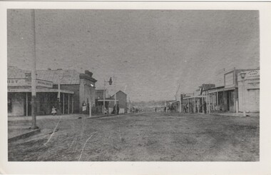 Rutherglen Historical Society
Image, c1870
Very early photograph of Main Street, Rutherglen, probably toward the end of the gold rush. The Oriental Bank shown on the right of the photo closed around 1870.Black and white photograph of Main Street looking east.main street, rutherglen, oriental bank -
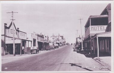 Rutherglen Historical Society
Image, c1940-1950
At the centre of the photo, on the left hand side of the road, is the Star Hotel. On the right hand side of the road, in the foreground is the Cumberland Hotel. Further along on the right of the road is the Rutherglen Hotel (now Poachers Paradise Hotel).One of three black and white photographs mounted on orange paper. This one of Main Street looking west.Printed at the bottom of the photo: "V5 Main Street, Rutherglen" Written on mount: "Main St. Looking east from western end. Circa late 40's early 50's"main street, star hotel, rutherglen hotel, poachers paradise hotel, hotels, shops, cumberland hotel -
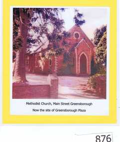 Greensborough Historical Society
Photograph, Unknown, Methodist Church Main Street Greensborough, 1940c
The Greensborough Methodist Church stood in Main Street Greensborough and was central to the social life of the suburb in the early 20th century. This original site is now part of the Greensborough Plaza shopping complex. The Church moved to the new building in Grimshaw Street circa 1970s. This photograph shows the red brick church, now demolished.Copy of colour photograph of red brick church, mounted on yellow card and laminated.Caption: 'Methodist Church, Main Street Greensborough. Now the site of Greensborough Plaza'methodist church greensborough -
 Eltham District Historical Society Inc
Photograph, Margaret Ball, 32 Pryor Street, Eltham, June 1999, 1999
... streets ...Owner: Mr and Mrs Warren Snr, parents of H.E. Warren of 30 Pryor Street. Sold 17 March 2001The Margaret Ball (Pre 1960s Houses) Collection was a personal project initiated to mark the year 2000 and arose as a result of the disappearance of many pre-1960s parts of Eltham due to development. Approximately 200 pre-1960s style houses that were left in Eltham between Main Road and east to Bible Street, between Cecil Street to the north and south to Dalton Street were photographed in late 1999. Not all of the houses could be photographed; some because the garden or trees blocked the view of the house, others because of rubbish or cars were in the way, some because people were working on the house or in the gardens at the time.Roll of 35mm colour negative film, 10 stripsFuji 200eltham, houses, streets, margaret ball (pre 1960s houses) collection, pryor street -
Port Melbourne Historical & Preservation Society
Functional object - Shopping Bag, Bay Street Traders Association, 2001
Produced by and for the Bay Street Traders Association. .01 was produced first and printed on clear plastic, which made the images unreadable. Hence .02 was produced and printed on white plastic. Note that the 2000 scene is a computer generated image of what Bay Street may look like in the future, not as actually was in 2001. Similarly, the scene portrayed for 1800 does not reflect any reality as Liardet only landed at Sandridge in 1839. It may be an 1890s view.Black and white plastic promotional bag produced by the Bay Street Traders Association, purporting to show scenes of Bay Street in 1800 (sic) and 2000. Bears the Association logo.advertising, business and traders, bay street traders association, bay street -
Port Melbourne Historical & Preservation Society
Functional object - Shopping Bag, Bay Street Traders Association, 2001
Produced by and for the Bay Street Traders Association . .01 was produced first and printed on clear plastic, which made the images unreadable. Hence .02 was produced and printed on white plastic. Note that the 2000 scene is a computer generated image of what Bay Street may look like in the future, not as actually was in 2001. Similarly, the scene portrayed for 1800 does not reflect any reality as Liardet only landed at Sandridge in 1839. It may be an 1890s view.Black on clear plastic promotional bag produced by the Bay Street Traders Association, purporting to show scenes of Bay Street in 1800 (sic) and 2001. Bears the Association logo.advertising, business and traders, bay street traders association, bay street -
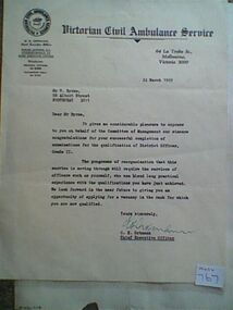 Ambulance Victoria Museum
Letter, Victorian Civil Ambulance Service to Walter Byrne, 24 March 1969
When he died in 2007, Wally Byrne, left a legacy of public service that many would be proud to emulate. Having served in the Royal Australian Navy in the Pacific during the Second War World War, Wally later joined the Victorian Civil Ambulance as an ambulance officer. In a career that spanned more than 35 years, Wally was based at Lonsdale Street, Latrobe Street and Fairfield. He became Station Officer at the busy Latrobe Street before moving into the Mobile Intensive Care Ambulance (MICA) system. Promoted to District Officer he became officer in charge of communications and served in this role until his retirement. Chas Martin, one of Wally’s communications staff at Latrobe Street, recalled that Wally was an efficient and well liked manager. He was also a very social person. Having purchased a block of land at Christmas Hills, Wally and his family hosted regular weekend BBQ’s there for his communications staff, other ambulance officers, and their families. Wally’s son Jon, later joined Ambulance Victoria, became a paramedic and now holds a senior role in the organisation. White paper with Victorian Civil Ambulance Service logo top left corner and letterhead at topMR W. BYRNE, 88 ALBERT STREET FOOTSCRAY 3011 -
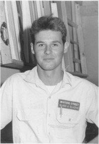 Lakes Entrance Regional Historical Society (operating as Lakes Entrance History Centre & Museum)
Photograph, Lakes Post Newspaper, 1995
Also photo of Glass and Glazing Shop in Whiters StreetBlack and white photograph of Andrew Wheeler apprentice with Whiter Street Glass and Glazing, awarded best in entire Housing Industrial TAFE course Lakes Entrance Victoria. Also photo of Glass and Glazing Shop in Whiters Street.businesses, people