Showing 123774 items matching "main-road"
-
 Warrnambool and District Historical Society Inc.
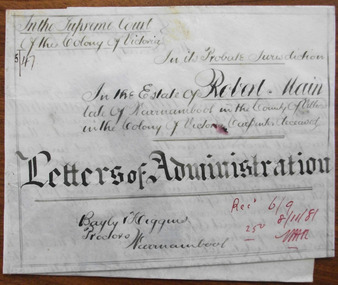
Document - Robert Main Letters of Administration 1881, 1881
Nothing is known of Robert Main except that he was a Warrnambool carpenter who had a wife named Jane and he died on 9th August 1880. He left an estate to the value of £35. The Warrnambool lawyers, Bayley and Higgins operated in Warrnambool in the 1880s. Mr Bayley came from Port Fairy and Jabez Higgins, well-known in Warrnambool for his sporting and community interests, purchased the legal practice of Bayley and Higgins with his brother in 1875. Jabez Higgins built the residence, ‘Corio’ in Warrnambool and died in 1886. Tait collection: item 6 of 62This document is of significance only in that it is an example of probate papers drawn up by Warrnambool solicitors for a deceased Warrnambool resident in the 1880s. This is a piece of white parchment with ruled black lines and folded and sealed at the bottom with a seal of the Supreme Court of the Colony of Victoria. The seal is attached to the document by a blue ribbon. There is also a red stamp of the Master in Equity of the Supreme Court. The document is dated 1881. Apart from some minor staining the document is in good condition. The material is handwritten in black and red ink‘In the Supreme Court of the Colony of Victoria, in its Probate Jurisdiction, in the Estate of Robert Main, late of Warrnambool, in the County of Villiers in the Colony of Victoria, carpenter, deceased, Letters of Administration, Bayly and Higgins, Proctors, Warrnambool, Recd. 6/9, 25o, 8/11/81, W.A.R.’robert main, bayley and higgins, solicitors -
 Eltham District Historical Society Inc
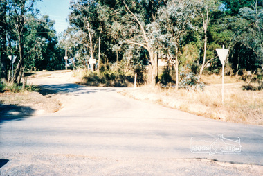
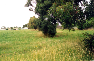
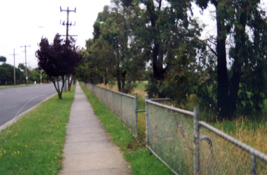
Photograph, Thompson Crescent area, Research
Three colour photographs of roads in the Thompson Crescent area, Research 1. Norman Road/Keith Court 2. Reynolds Road/Thompson Crescent North and Nicholson Street 3. Thompson Crescent, Researchthompson crescent, norman road, keith court, reynolds road, nicholson street, research -
 Ringwood and District Historical Society
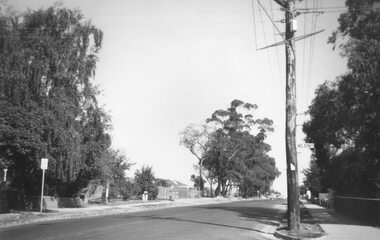
Photograph, Ringwood Street at Nelson Street Ringwood, looking south, early 1960s prior to Eastland development
Black and white photograph showing made road. Telegraph pole on right of picture. Tall trees to left of photograph. Houses either side of road. Road sign on telegraph pole reads, "Nelson St."Typed below photograph, "Ringwood St. looking south. Ringwood Reserve to left of row of trees in centre." -
 Whitehorse Historical Society Inc.
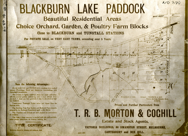
Document, Blackburn Lake Paddock
Brochure of Blackburn Lake Paddock consisting of 23 residential areas,Brochure of Blackburn Lake Paddock consisting of 23 residential areas, orchard, garden and poultry farm. Bounded by railway to Lilydale, Central Road, Lake Road, Springvale Road and close to Blackburn and Tunstall Stations.Brochure of Blackburn Lake Paddock consisting of 23 residential areas,t. r. b. morton & coghill, johnstone & tait, mccarron bird & co., blackburn lake paddock, central road, blackburn, lake road, springvale road, nunawading -
 Whitehorse Historical Society Inc.
Photograph, Narmara Primary School, 13/01/1994 12:00:00 AM
Coloured photo of Narmara Primary School looking North along East boundary. School on North side of Highbury Road between Middleborough Road and Blackburn Road. Since demolished and site developed for housing.narmara primary school, warner, philip -
 Whitehorse Historical Society Inc.
Photograph, Narmara Primary School, 13/01/1994 12:00:00 AM
Coloured photo of Narmara Primary School site looking West along Highbury Road. School on North side of Highbury Road between Middleborough and Blackburn Roads. Since demolished and site developed for housing.narmara primary school, warner, philip -
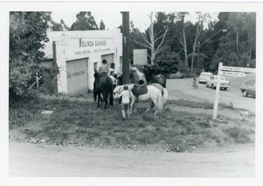 Mt Dandenong & District Historical Society Inc.
Photograph, Pony Club Outside Olinda Garage 1960s, c1960
Olinda garage on corner of Range Road and Mt Dandenong Tourist Road. Pony Club with 4 horses on grass. ralph Jones was garage owner at this time. Dragster bike on road indicates early 1960s.pony club, olinda garage, garage, olinda, range road, mt dandenong tourist road, ralph jones -
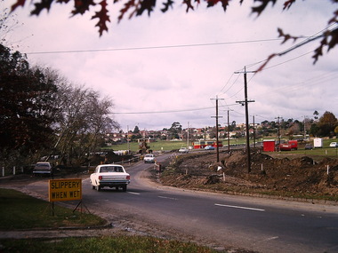
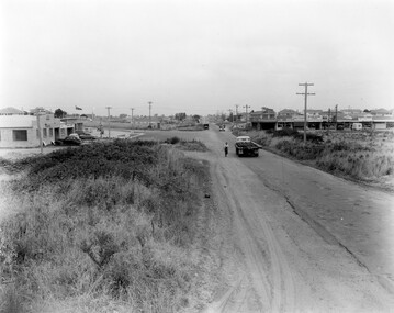 City of Kingston
Photograph - Black and white, 1957
This image shows the increasing urbanisation of the formerly rural area of Moorabbin.Black and white photograph of the intersection of South Road and Chesterville Road, Moorabbin. A service station is visible on the left hand side, a truck is travelling along the road and shops are under construction on the right hand side.Handwritten in blue ink on reverse: 57-523B Handwritten in red ink on reverse: 100%moorabbin, shopping strip, paddocks, roads, cars -
 Whitehorse Historical Society Inc.
Photograph - ColouredPhotograph, Narmara Primary School, 13/01/1994 12:00:00 AM
Coloured photo of Narmara Primary School, looking North from south boundary. School on North side of Highbury Road between Middleborough Road and Blackburn Road. Since demolished and site developed for housing.narmara primary school, warner, philip -
 Glen Eira Historical Society
Letter - EMMAUS REST HOME
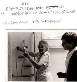
This file contains two items pertaining to Emmaus Rest Home: 1/A series of emails exchanged between local resident Mark Upton and John O’Callaghan of the Glen Eira Historical Society, dated 30/01/2008 and 31/01/2008, regarding the history of a derelict property situated at 41 Murrumbeena Road. In the first email, Upton refers to the property of ‘Oakdene’ Aged Care Facility and inquires as to whether the Society possesses any information on it. The next day, O’Callaghan replies that he will investigate. Later that day, Upton recommends O’Callaghan some information on the property he unearthed via Joanne (Jo) Antoni, Executive Assistant at Churches of Christ Community Care. The property turns out to have originally been a private residence owned by the Birtchnell family, sold on 24/01/1945, eventually acquired by the Church and converted into an aged care facility which closed on 16/07/1999 2/Three black-and-white photographs. Two of the photographs portray a resident of the Home, Mrs. Armstrong, and a staff member of the Home, Sr. Johnston, in a bathroom operating a shower. These photographs contain writing on the back identifying the persons. The remaining one portrays Mrs. Armstrong and another, unidentified resident of the Home seated in a bedroom. This one also contains writing on the back, but specifying the name only of the facility. None of the photographs are dated.emmaus, emmaus rest home, emmaus home for the aged, churches of christ community care, antoni joanne (jo), new cumloden grammar school, atkin william t., betheden, waghoo road, ‘oakdene’ aged care facility, carnegie, murrumbeena, upton mark, o’callaghan john, murrumbeena road, neerim road, dandenong road, birtchnell family, birtchnell james, birtchnell elizabeth, birtchnell harold, birtchnell olive, birtchnell kingsley, oakdene crescent, clay will h., johnson sr., armstrong mrs., anglican church, nursing homes, retirement homes, mansions, clocks, fires -
 Ringwood and District Historical Society
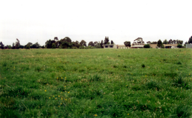
Photograph, Last post of stockyard, Blood's paddock, corner Wonga and Warrandyte Roads, Ringwood 1910 (4 views)
4 small sepia photographs Written on reverse 2434-1 & -2: "Part of old stockyard, Blood's Paddock, Wonga Road. Arnott's, 1910." 2334-4: "Last post of stockyard in Blood's Paddock, corner Wonga Road and Warrandyte Roads" -
 Geelong Cycling Club
Pennant Flags, 1948
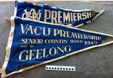
Amateur pennant- Russell Mockridge was a magnet for the Club and just after he had ridden in 1948 Olympic Games, good riders were attracted to the Club.How does a Club grow? We note the effect if a very good rider in Russell Mockridge to inspire others.Two felt pennant flags in blue with white trims."VACU Premiership/Snr Country Road/Won by Geelong/1949" "VACU Premiership: Runners Up/Senior Country Road/ 1951"vacu; premiership; senior country road; won by geelong; 1949;, vacu; premiership; runners up; senior country road; 1951; -
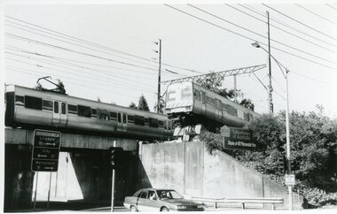 Ringwood and District Historical Society
Photograph, Train Accident - Wantirna Rd Railway Bridge, Ringwood 1992
B&W photograph taken by Ringwood Historical Research Group:8.12.92 Train mishap Wantirna Road Bridge -
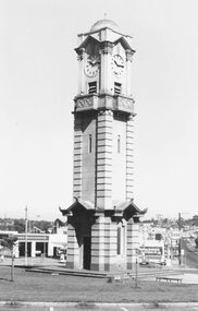 Ringwood and District Historical Society
Photograph, Maroondah Highway West, Ringwood- 1974. Clocktower on new site
Black and white photographClocktower on corner of Maroondah Highway and Wantirna Road. -
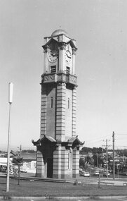 Ringwood and District Historical Society
Photograph, Maroondah Highway West, Ringwood- 1974. Clocktower on new site
Black and white photographClocktower on corner of Maroondah Highway and Wantirna Road. -
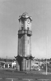 Ringwood and District Historical Society
Photograph, Maroondah Highway West, Ringwood- 1974. Clocktower on new site
Black and white photographClocktower on corner of Maroondah Highway and Wantirna Road. -
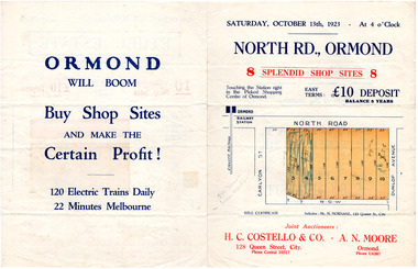 City of Moorabbin Historical Society (Operating the Box Cottage Museum)
Flyer - North Road, Ormond - H. C. Costello & Co A. N. Moore, 1923
The train line from the city to Frankston was electrified which intensified the sale in the municipality of Moorabbin, particularly land which was in the vicinity of the railway stations.Example of the progress of the Municipality of MoorabbinAdvertising flyer for auction of real estate sales - plan of building blocks for shops for saleNorth Road, Ormond - 8 shop sitesnorth road, ormond, real estate, auctions -
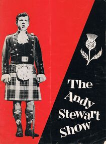 Bendigo Historical Society Inc.
Document - PROGRAMME BOOKLET: ''THE ANDY STEWART SHOW'', 1960's
Programme booklet - ''The Andy Stewart Show'' - Stadiums Pty Ltd production - Festival Hall (for Melbourne performance - on Australian Tour ca. 1962/63.Freelance Press, City Road, South Melbourneentertainment, theatre, the andy stewart show -
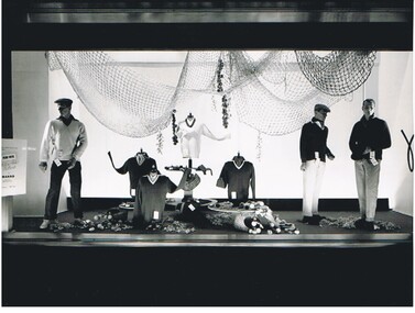 Bendigo Historical Society Inc.
Photograph - HANRO COLLECTION: SHOP DISPLAY
Black and white photograph of a shop window display of Hanro Products, location unknown. Possibly Melbourne somewhereLloyd Hull, 27 Canterbury Road , Blackburnorganization, business, hanro, hanro products, shop window display, lloyd hull, canterbury road blackburn -
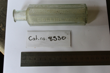 Coal Creek Community Park & Museum
Glass Bottle
Small clear octagon bottleJoseph Cabriel. 69, Simpson's Road Collingwood -
 Whitehorse Historical Society Inc.
Pamphlet, Hoechst, c1969
Hoechst - leaders in chemistryHoechst - leaders in chemistryHoechst - leaders in chemistryhoechst, chemistry -
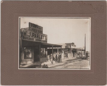 Rutherglen Historical Society
Photograph - Image, 1920 (Approximate)
Parlett's store was situated in Audley Street opposite the wheat silos. Ada Parlett, W. T. Parlett's neice is a concert pianistPhotograph of Parlett's Store, Rutherglen with Mr W.J. Parlett and Mr Bob Ready standing outside store, black and white, mounted on a thick beige card.On reverse of mount: "Brown Plains Road / Rutherglen"parletts store, w j parlett, bob ready, audley street, brown plains road -
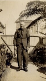 Linton and District Historical Society Inc
Photograph, Tom Jones, c1940
Thomas Jones, the son of Matthew Jones and Ann Jones, nee Parker, was born at Banongill Station near Skipton in 1859. He died at Linton in 1942. The photograph was probably taken in the garden at Murrell's newsagency in Sussex Street, Linton - Tom and Bill Murrell were good friends.Black and white photograph of a man wearing a suit, standing on a garden path.On back: "Thomas Jones, Geelong Road, Linton".thomas jones, old lintonian collection, tom jones -
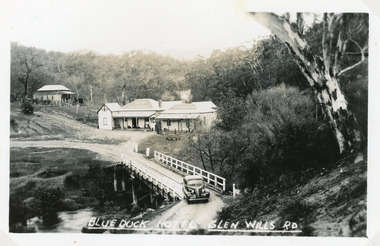 Lakes Entrance Historical Society
Postcard - Blue Duck Hotel, 1940
Hotel buildings moved from Omeo to present site, 1928 by William O'ConnellBlack and white postcard showing Blue Duck Hotel, Glen Wills Rd, East Gippsland, Victoria. Bridge over Mitta Mitta River, house at back, sedan car leaving bridge, dense forest surrounding.Blue Duck Hotel Glen Wills Roadbridges, hotels -
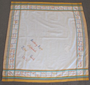 Uniting Church Archives - Synod of Victoria
Textile - Tablecloth
Square tablecloth with text embroidered in squares around edges. The cloth has a yellow, blue, green and red border."Darling Road Methodist Ladies Guild 1939"methodist ladies guild, darling road east malvern methodist church -
 Kew Historical Society Inc
Photograph - Construction of the Eastern Freeway (F19), Ron Setford, March 1972
Ron Setford and his wife Grace Setford lived in Tanner Avenue, East Kew, from c.1946 to c.1995. A keen photographer, he recorded the changing face of Kew over a 20 year period. Apart from 30 photographs of built structures and places in Kew dating from 1960 and 1961, 145 of his 35mm colour slides chronicle the development of the F19 (later renamed Eastern) Freeway through the Yarra Valley in Kew over a five year period from c.1972 to c.1977. This important collection was donated to the Society by his granddaughter in 2025.This collection of 175 35mm slides is of local and statewide significance, owing to its subject matter, particularly the major development of road transport infrastructure during the 1970s with the construction of the Eastern Freeway. The photographer also took care to annotate and date most of his slides which enable the researcher to pinpoint temporal and spatial locations.Kilby Rd, Willsmere Park on left"Eastern Freeway / Kilby Road / Nov 72"ron setford, eastern freeway, f19 freeway, willsmere park, kilby road -
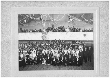 Chelsea & District Historical Society Inc
Photograph - Ball for opening of Mason's Theatre, Station Street, Chelsea, 1923
The theatre was built by Mr William James Mason in 1922/23.Black and white photo on a backing sheet. A large group of people, formally dressed, some standing on the floor of the theatre and others in the balcony area of the theatre.F. Cumming Studio, Frankston Road, Chelsea.theatre, chelsa picture theatre, mason's theatre, celebrations, chelsea, plaza theatre -
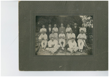 Chelsea & District Historical Society Inc
Photograph - Cricket team and officials, c 1910
Black and white photo on mounting board of a cricket team and the officials, with the names of the peopleF. Cummings Studio Frankston Road, Chelseacricket, sport, chelsea -
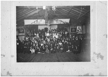 Chelsea & District Historical Society Inc
Photograph - Fancy Dress Ball, Edithvale Boat Club, c 1923
Fancy Dress Ball held at Edithvale Boat Club.A photograph of men, women and children attending a fancy dress bal at Edithvale Boat Club. On the rear of the photo ten people have been identified: 1 - Mr Case; 2 - Mr and Mrs Plain (owner of the Unity Theatre); 3 - Mr Rowe; 4 - Mrs Bert Smith; 5 - Alf Case; 6 - Sid Munro; 7 - Bert Richardson; 8 - Marg Upton; 9 - Nellie Cameron; 10 - Arthur Upton. F. Cumming Studio. Frankston Road, Chelseacarrum, chelsea, carrum mechanics hall, fancy dress ball, social function, clothing -
 Kew Historical Society Inc
Plan - Subdivision Plan, Balwyn Theatre and Shop Sites, circa 1927-28, c.1927-28
The Kew Historical Society's map collection includes a substantial number of real estate subdivision plans, mainly of Kew but also of surrounding suburbs in Melbourne. Most of the subdivision plans date from the 1920s and 1930s when the districts old homes and local farmland were being split up to accommodate residential growth in the postwar period. These early plans were assembled by a local firm, Jas R Mather & McMillan, which had an office in Cotham Road. Many of the plans, and sometimes photos, were annotated by the agents. The ‘new’ Balwyn Picture Theatre was built and owned by Balwyn Theatres Pty Ltd in ca. 1928. By 1930, this first Balwyn Theatre was destroyed by fire after a break-in. Following the fire, a new cinema was constructed. This plan for a Cinema and eleven shops presumably dates from 1927/28 when the Company announced that this location in Whitehorse Road ‘was the most central and best suited [area] for their Theatre and shops’.Subdivision plans are historically important documents used as evidence for the growth of suburbs in Australia. They frequently provide information about when the land was sold as well as evidence relating to surveyors and real estate and financial agents. The numerous subdivision plans in the Kew Historical Society's collection represent working documents, ranging from the initial sketches made in planning a subdivision to printed plans on which auctioneers or agents listed the prices for which individual lots were sold. In a number of cases, the reverse of a subdivision plan in the collection includes a photograph of a house that was also for sale by the agent. These photographs provide significant heritage information relating house design and decoration, fencing and household gardens.The photograph may also be aesthetically significant depending on the importance of the photographic atelier.Subdivision plan showing the Balwyn Theatre and its adjoining shop sites in Whitehorse Road Balwyn. The 11 shop sites were noted for their depth (133 ft - 145 ft. [Map.0041]balwyn theatre -- balwyn (vic.), subdivisions -- balwyn (vic), subdivision plans