Showing 123773 items matching "main-road"
-
 Whitehorse Historical Society Inc.
Article, Up and over to school
The Country Roads Board has released details of the overpass to be built over Whitehorse Road outside Blackburn Primary School.The Country Roads Board has released details of the overpass to be built over Whitehorse Road outside Blackburn Primary School.The Country Roads Board has released details of the overpass to be built over Whitehorse Road outside Blackburn Primary School.victoria. country roads board, whitehorse road, blackburn, blackburn primary school, no. 2923 -
 Whitehorse Historical Society Inc.
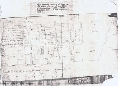
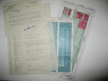
Document, South Riding
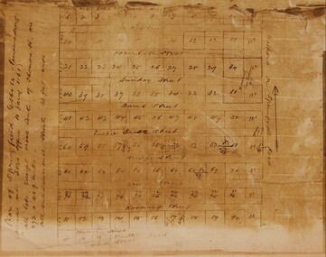
Plan showing owners of land in the South Riding of the Shire of NunawadingPlan showing owners of land in the South Riding of the Shire of Nunawading 1888. South Boundary Road is now Highbury RoadPlan showing owners of land in the South Riding of the Shire of Nunawading land subdivision, shire of nunawading. centre riding, dandenong creek, fulton, dr, shire of nunawading. south riding, arundale, w, h. arnold & co. -
Whitehorse Historical Society Inc.
Pamphlet, Information Bulletin, 1/12/1993
Freeway Extension between Doncaster Road and Springvale Road to go ahead.Freeway Extension between Doncaster Road and Springvale Road to go ahead. Map showing location and history of project given.Freeway Extension between Doncaster Road and Springvale Road to go ahead. freeways, doncaster road, doncaster, springvale road, nunawading, vicroads, city of nunawading, city of camberwell, city of box hill, city of ringwood -
 Whitehorse Historical Society Inc.
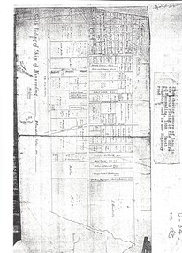
Map, Shire of Nunawading 1888
Plan showing owners of land in the South Riding of the Shire of Nunawading, 1888. South Boundary Road is now Highbury Road.shire of nunawading. south riding, south boundary road, burwood east, highbury road, springvale road, mahoneys road, forest hill, holland road, blackburn south, burwood highway -
 Whitehorse Historical Society Inc.
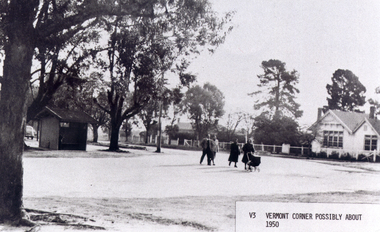
Photograph, Vermont Corner
Black/white - Vermont - Corner of Canterbury Road and Mitcham-Boronia Roads with Vermont Primary School, possibly about 1950vermont primary school no. 1022, canterbury road, vermont, mitcham road, boronia road, mitcham, armstrong, ian -
 Whitehorse Historical Society Inc.
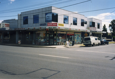
Photograph, Rangeview Shopping Centre, 1998
Coloured photograph showing newsagent at Rangeview Shopping Centre. Corner of Mitcham Road and Carween Avenue. Mitcham Road in forefront.rangeview shopping centre, shopping centre, shops -
 Whitehorse Historical Society Inc.
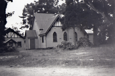
Photograph, St Lukes Church - Vermont, c. 1951
Black and white photograph of original St Lukes Church corner of Mitcham Road and Canterbury Road, Vermont. c 1951st lukes anglican church, canterbury road, vermont, mitcham road, tresider, dot -
 Whitehorse Historical Society Inc.
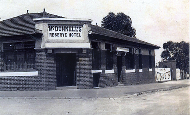
Photograph, McDonnell's Reserve Hotel 2
Black and white photograph of McDonnell's Reserve Hotel, south-east corner Whitehorse Road and Mitcham Road Original on CDROMreserve hotel, mitcham, mcdonnells, whitehorse road mitcham, mitcham road -
 Whitehorse Historical Society Inc.
Photograph - Coloured photograph, Forest Hill Intersection| Canterbury and Springvale Roads
Coloured photograph of the intersection. Springvale Road in the foreground. Canterbury Road heading toward Forest Hill Chase Shopping Centre.canterbury road, springvale road forest hill -
Canterbury History Group
Photograph - G. Robinson's butcher shop, [1900]
Display in the window of G. Robinson, s butcher shop in Canterbury Road, opposite Highfield Road. Black and white photographcanterbury, butcher shops, canterbury road, robinson> george, window displays, food -
Canterbury History Group
Photograph - Bowling at the Canterbury Bowling Club c.1917, c.1917
Sepia photograph of bowling at the Cantebury Bowling Club .c 1917. Canterbury Buildings, Canterbury Road and Balwyn Road in backgroundcanterbury, canterbury bowling club, lawn bowls, canterbury buildings, canterbury road, balwyn road -
Canterbury History Group
Document - Balwyn Road Canterbury, c1990
Handwritten notes about early Balwyn Road between Canterbury Road and Erica Street, supplied by Eileen Fisher [1900?]canterbury, balwyn road, erica street, canterbury road, fisher> eileen -
 Whitehorse Historical Society Inc.
Map - Civic Map, Subdivision of Village of Springfield, 1861
Map of the subdivision of the Springfield Estate, Nunawading, 1861. The Springfield Estate was located in the Northwest corner of Whitehorse Road and Springvale Road.Map of the subdivision of the Springfield Estate, Nunawading, 1861. Springfield Estate was located in the Northwest corner of Whitehorse Road and Springvale Road.non-fictionMap of the subdivision of the Springfield Estate, Nunawading, 1861. The Springfield Estate was located in the Northwest corner of Whitehorse Road and Springvale Road.springfield estate, whitehorse road nunawading, springvale road nunawading -
Canterbury History Group
Photograph - Several Maling Road traders in period costume standing the the laneway of Maling Road waiting for a photograph to be taken, Jan Pigot, 27/03/1993 12:00:00 AM
Coloured photograph of several Maling Road traders in period costume standing the the laneway of Maling Road waiting for a photograph to be takencanterbury, maling road, shops, fashion, laneways -
Canterbury History Group
Photograph - Group of Maling Road traders in period costume having their photograph taken in Maling Road, Jan Pigot, 27/03/1993 12:00:00 AM
Coloured photograph of a group of Maling Road traders in period costume having their photograph taken in Maling Road. The Block is in the backgroundcanterbury, maling road, shops, fashion -
Canterbury History Group
Photograph - Street view of the enamel picture plaque for Maling Road in the 1920s, Jan Pigot, 2004
Coloured photograph of the enamel picture plaque for Maling Road in the 1920s on the red brick wall of No. 80 Maling Road, Canterburycanterbury, maling road, shops, signs, plaques -
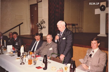 Bendigo Military Museum
Photograph - BENDIGO RSL ANNUAL DINNER, Aug 1988
Bendigo RSL Annual Dinner held in the Soldiers Memorial Institute Main Hall in 1988. The white Cross was placed on the stage for such each Dinner. .1) Standing is Bruce Ruxton Guest speaker, State President of the Victorian RSL, seated to his left is Max O'Haloran Bendigo RSL President, others are unknown. .2) On the right of the photo at end of the table is possibly Col Mc Murray Rats of Tobruk Association, 2nd from right is Harold Trahair Eaglehawk RSL.. .3) Standing from the left is Max O'Haloran, refer Cat No 8129P, Bruce Ruxton, Frank ................, seated is Jack Plant, refer Cat No 8129PThree photographs, colour re an Annual Dinner Bendigo RSL Sub Branch. .1) Shows the head table at the stage end of the Soldiers Memorial Institute Main Hall, Standing is the guest speaker Bruce Ruxton, seated are 6 others. .2) Further out view of .1) showing one standing and 8 seated. .3) Shows 3 standing and 1 sitting.brsl, smirsl, annual, dinner -
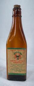 City of Moorabbin Historical Society (Operating the Box Cottage Museum)
Domestic object - MY-T-FINE Methylated Spirits, 1945-1970
Lucknow Manufacturing Company was located at 103 Brunswick Road, Brunswick in the mid 1930s. In 1937, Lucknow Manufacturing Company was fined for selling methylated spirit which was adulterated (The Age, 19 August, p. 4.) In the early 1940's the company moved to a larger premises in Mount Alexander Road, Flemington, where this particular bottle was produced. Amber bottle with cork stop. White paper label printed in green and red.Poisonous - Not to be taken - MY-T-FINE Methylated Spirits Guaranteed full strength 65-68 O.P. Highly Inflammable Keep away from Fire Contents Approx. 10 ozs Lucknow Manufacturing Co. 96-100 Mt. Alexander Road, Flemington Phone: FF 2094lucknow manufacturing company, methylated spirits -
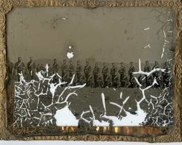 Flagstaff Hill Maritime Museum and Village
Photograph - Glass plate, circa 1866
This glass plate photograph shows good detail of members of the Warrnambool Garrison posing for their photograph in front of a young township. There are other well-dressed citizens behind them. The three men with frogging on their sleeves were commanders were likely to be commanders. The men are facing north with Cannon Hill and the fortification area in the background. It dates from the 1860s. The firearms held appear to be 1853 pattern Lee Enfield muskets used by the British army in Crimea at this time and in Australia, rather than the later Martini Henry cartridge rifles. The uniforms match other photos of the Warrnambool Garrison Militia and Band in our Collection, taken up until the 1880s. The three storey building in the photograph is likely to be the Manifold & Bostock flour mill, built in 1854 near the ‘cutting’ in Merri Street, which was one of the main streets at the time; if one faced the building’s front from a vantage point and looked south to south-east, the hills around Flagstaff Hill and Cannon Hill would be behind that mill, and the Harbour behind the hills. This is the area of the Fortifications. The glass plate method of photography was widely used during the mid-19th to early-20th century. The donor and maker of the photograph are unknown. Around this time the citizens of Victoria were prospering from the gold rush but felt isolated and uneasy about their security in the colony. In 1854 the Volunteer Act was passed to provide some military defence. In 1858 the Warrnambool Volunteer Rifle Corps was established, disbanded in 1863, then a new Warrnambool Detachment was formed in September 1866. Legislation was passed in 1884 that replaced the volunteers’ corps with a partly paid, permanent Militia Defence Force. The batteries manning the coastal forts of Victoria were termed Garrison Artillery Companies. When the Army was federated in 1901 there were eight Militia Companies in Victoria. Warrnambool and Port Fairy together were known as 8 Coy AGA (Australian Garrison Artillery). Changes to formation and name continued into the 20th century.This photograph is a record of the very early local defence force, circa 1866. The photograph signifies the connection of the colony in Victoria to the growing need for security due to the unrest in Europe at that time. The photograph is also locally significant to the industry of the young township of Warrnambool, showing what is likely to be one of the first flour mills in the town. The photograph is also the only example of the early methods of glass plate photography in our collection. Photograph, rectangular glass plate, positive sepia image. Photograph has brass framed edges that fold over to the back, with mitred corners. The front edges are pressed with a decorative floral pattern. The photograph shows a group of thirty military men, standing or kneeling, in dark uniforms with pillbox forage caps, round-collared jackets with light buttons, light sashes worn from top left shoulder to bottom right side of waist belt, and long, straight-legged trousers. Three of these men have light braid around the buttons on the front of their jackets, light frogging on their sleeve cuffs and stripes on the outside seams of their trousers. The other twenty-seven men have plain uniforms and are holding firearms in their right hands, steadied with their left hands. Other figures are standing behind this group of soldiers, including three or four men wearing top hats, jackets and ties. In the background is a row of buildings. The central building is three stories high. Bare hills are in the far background. The foreground is uneven ground with patches of short grass. Photographer looking towards the south east and Cannon Hill, with the Warrnambool Garrison facing north, ca.1860s.flagstaff hill, warrnambool, shipwrecked coast, flagstaff hill maritime museum, maritime museum, shipwreck coast, flagstaff hill maritime village, great ocean road, glass plate, photography 19th century, colonial forces, military defence, volunteer act 1854, volunteer rifle, garrison artillery, volunteer corps, militia, militia garrison band, pillbox forage caps, helpmann, manifold and bostock, 1853 lee enfield musket, tintype, warrnambool garrison, 1860s, cannon hill, manifold & bostock, flour mill, 3-storey building -
Whitehorse Historical Society Inc.
Document, Monier Wunderlich Tile Factory, 1989-96
Papers concerning sub-division of the former Monier-Wunderlich Tile Factory site.Papers concerning sub-division of the former Monier-Wunderlich Tile Factory site between Rooks and Mitcham Roads Vermont. Includes City of Nunawading planning documents and correspondence with residents; Wunderlich Residents' Action Group circulars; correspondence and drafts by W & B Gray relating to the proposals.Papers concerning sub-division of the former Monier-Wunderlich Tile Factory site. wunderlich limited, monier-redlands pty ltd, mitcham road, mitcham, rooks road, vermont, nos. 147-157, wunderlich residents' action group, rosstrevor crescent, mitcham, redlands properties, gray, william, gray, beryl -
 Kew Historical Society Inc
Photograph - Verandah of 'Wimba', 235 Cotham Road, John T Collins, 1979
Although probably built some time earlier, the first mention in the Rate Books of the property later known as 'Wimba Lodge' appears in the entry for 1870 when the property, owned by John Sharpe Denbigh, a civil servant, was given an N.A.V. of £72. Denbigh did however occupy a house in Cotham Road in 1863, and it is possible that was the same premises'. The house was occupied by Sharp until at least May 1876 when the 'family residence ... was auctioned' to Carlington George Edmund Marston, a chemist of Smith Street, Collingwood. At the time of the auction the house was described thus: The residence and grounds of the late J.S. Dendigh, situate in the most elevated part of Cotham Road Kew. The grounds comprise an area of 4a Or 29p or thereabouts, and have a frontage to Cotham-road of 4 chains. The house has two large rooms in front, with 6ft hall built of brick, bay and side windows (plate glass), four rooms of wood behind with slate roofs, bathroom and closets, detached kitchen and servant's room, large shed with washing boiler, pantry and cellar under, brick and cement tank, and the Yan Yean laid onto house and grounds, cowshed, pigstye, &c, the whole securely fenced. First class orchard and flower garden. The paddocks laid with English grasses and drained... .' (Sanderson P. Kew Conservation Study Vol 2)'Wimba' is a single storeyed rendered house. The front entrance is flanked by two polygonal bay windows, and a verandah with a concave corrugated iron roof returns around three facades, and accentuates the projections of the windows. The solid render parapet is very ornate and tall for the date of construction. It has panels of decoration along it and is surmounted by a number of render urns. (Sanderson P. Kew Conservation Study Vol 2)Reverse: "JOHN COLLINS / 11 Anderson Road / Hawthorn East, 3123 / Film 395 Exposure 15A / Kew / Wimba / Front verandah from east / 7-4-79wimba lodge, 235 cotham road -- kew (vic.), john s denbigh, carlington george edmund marston -
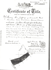 Whitehorse Historical Society Inc.
Land Title, Certificate of Title, 5/11/1910 12:00:00 AM
Photocopy of Certificate of Title issued to Mary Ann Jeffery of Sevenoaks Park, Blackburn Road, Blackburn for land between Blackburn Road and Lake Road dated 5 November 1910. Incomplete note refers to 'Railway'.sevenoaks park, blackburn road, blackburn, lake road, jeffery, mary ann -
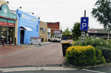 Whitehorse Historical Society Inc.
Photograph, Enterprise Way Mitcham
Mitcham - Commercial Area behind Coles etcColoured photograph of Enterprise Way, Mitcham which is a pedestrian and service road between the shops on Whitehorse Road and Coles Supermarket and vicinity shops on Victoria Avenue.This photograph is looking west from Mitcham Road - 2012enterprise way mitcham, shops -
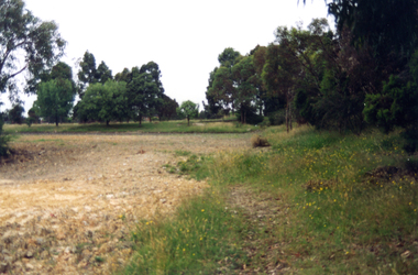
 Whitehorse Historical Society Inc.
Photograph - Coloured photograph, Narmara Primary School, 13/01/1994 12:00:00 AM
Coloured photo of Narmara Primary School Site, looking East from South East corner. North side of Highbury Road between Middleborough Road and Blackburn Road. Since demolished and site developed for housing.narmara primary school, warner, philip -
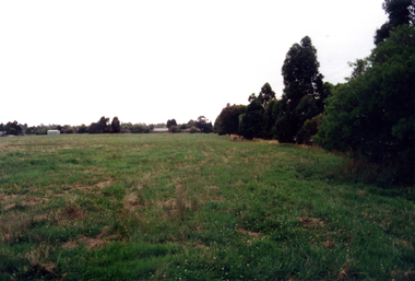
 Whitehorse Historical Society Inc.
Photograph - Coloured photograph, Narmara Primary School, 13/01/1994 12:00:00 AM
Coloured photo of Narmara Primary School, looking South from North West corner. School on North side of Highbury Road between Middleborough Road and Blackburn Road. Since demolished and site developed for housing.narmara primary school, warner, philip -
 Eltham District Historical Society Inc
Photograph - Aerial Photograph, Landata, Eltham, Vic, Apr. 1963
Centred on present day Zig Zag Road and Main Road, Eltham bounded by Maroondah Aqueduct to north, Thompson Crescent and Arthur Street to south, Parsons Road to east and Glen Park Road and Banks Road to west. Historic Aerial Imagery Source: Landata.vic.gov.au Aerial Photo Details: Project No :486 Project : MELBOURNE (1963) PROJECT Run : 5 Frame : 59 Date : 04/1963 Film Type : B/W Camera : RC8 Flying Height : 5100 Scale : 9600 Film Number : 1805 GDA2020 : 37°42'24"S, 145°08'52"E MGA2020 : 336716, 5825114 (55) Melways : 21 J3 (ed. 42)aerial photo, neil webster collection, eltham, 1963-04, arthur street, banks road, glen park road, maroondah aqueduct, melway 21j3, parsons road -
 City of Whittlesea
Document - Correspondence, Station Entrance and Railway Platform Estate, 1937
Letter from Ellison, Hewison & O'Collins Solicitors, Melbourne to the Shire of Whittlesea in reponse to a request for the names and addresses of the purchasers of blocks of land on the Station Entrance Estate and Railway Platform Estate, Thomastown. Both estates where originally subdived and sold in the mid 1920s. The collection includes a letter, a list of owners and their address details and the lot they own, and plans of both estates, which have been cut out of the original estate sale posters. Streets include High Street (Epping Road), Mount View Road, Pleasant Road, Central Avenue, Highlands Road and Main Street, ThomastownLetter, paper 3 pages, 2 plans. Letter from Ellison, Hewison & O'Collins Solicitors, Melbourne to the Shire of Whittlesea in reponse to a request for the names and addresses of the purchasers of blocks of land on the Station Entrance Estate and Railway Platform Estate, Thomastown. -
 Ringwood and District Historical Society
Flyer, Land Sale Advertisement - East Ringwood Township Estates, East Ringwood, Victoria - circa 1920
The date of the flyer as circa 1920 can be estimated from the references to the (decision on) "electrification of the Croydon Railway Line" which eventually occurred in 1923, letting of tenders for the state school building which opened in 1924, and the "proposed new railway station" (East Ringwood) which opened in 1925, Advertisement for three retail and residential allotment land sales in East Ringwood Township including maps showing layout of subdivisions. Township Estate, State School Estate, and East Ringwood Station Estate.Subdivision plans include Mount Dandenong Road, Grey Street, Eastfield Road, King Street, Everard Road, Holland Road, Purser Avenue, and Charles Street. (Agents) Spencer Jackson, Subdivider & Homebuilder, 341 Collins Street, Melbourne, Phones: M2327 (3 lines), also at Dromana, Phone 65. -
Whitehorse Historical Society Inc.
Map, Parish of Nunawading, 1927
Map of the Parish together with part of the Borough of Box Hill.Map of the Parish together with part of the Borough of Box Hill. Includes names of lease or license holders, sizes of leases and in some areas dates of leases. Roads, railway and stations marked. Original survey by W.J.Busocon, 1915. Manuscript note: 15.2.1927 Verified Dept. Lands and Survey.Map of the Parish together with part of the Borough of Box Hill. maps, parish of nunawading, borough of box hill -
 City of Kingston
Pamphlet - Colour, J. F. Brady, Matthiesson's Estate, Highett, c. 1905
Sales plan for land in the suburb of Highett, bounded by Tennyson Street, James Street and Point Nepean Road and including Maher Street, Connors Street, Enright Street, Edward Street, James Street and Matthieson Street.The developing urban area of Highett within the City of Kingston. This land sale pamphlet illustrates the subdivision of land within the municipality and the changing demographic of the district as new houses are constructed close to infrastructure.Colour pamphlet advertising for private sale subdivisions in the Matthiesson's Estate, Highett. Incorporates a map of the estate bordered by Tennyson Street, James Street and Point Nepean Road and including Maher Street, Connors Street, Enright Street, Edward Street, James Street and Matthieson Street.Handwritten in blue pencil: x marked on every subdivision on the map Handwritten in grey pencil at the end of the Price List: x not sold Handwritten in grey pencil adjacent to subdivisions 58, 167 and 166: JP. Turner Handwritten in grey pencil adjacent to subdivision 164: [indecipherable] Markings in grey pencil around the edges of the subdivision map Handwritten in grey pencil on reverse: Matthiesson / Matthiesson Estate / Matthiesson Estateland sales, estate, highett