Showing 26742 items matching "image"
-
 Wodonga & District Historical Society Inc
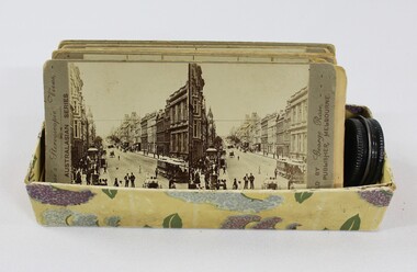
Card - Stereoscope Cards c. late 1800s - early 1900s
In the 1800s, the stereoscope was the only way to view with world in 3-D. A viewer would look through the lenses of the stereoscope's eyepiece to a card called a stereograph. On the stereograph, two of the same image were printed side by side, which when viewed through the stereograph transformed the one dimensional images into relatively life-like representations. A popular form of entertainment among the middle classes in Europe and America, people could use a stereoscope to view images of real faraway places, or fantastical magic scenes. The first patented stereo viewer was invented by Sir Charles Wheatstone in 1838, and remained a favoured leisure activity until the advent of cinema in the 1930s. This object contributes to our understanding of social life, leisure and entertainment in early twentieth century Wodonga, as well as providing interpretative capacity for themes including local history and social history. A cardboard box full of stereoscope cards showing street views and landscape scenery. stereoscope, stereographs, entertainment, fun, leisure -
 Flagstaff Hill Maritime Museum and Village
Container - Trinket Box, Johann A. Landmann, 1853
This trinket box was made by Johann Landmann during his journey on the sailing ship Wilhelmsburg and was donated to Flagstaff Hill by the wife of Landmann's great-grandson. Landmann (or Landman, also known as August Landmann) was born in 1826 in Ganhor, Silesia, Prussia. At the age of 20, he travelled through Europe, working from town to town as a cabinet maker. At 26 years old he returned to Germany, married Anna Rosina in Wahlstatt, Prussia, and on the same day sailed for Australia on the Wilhelmsburg in 1853, the year the ship was registered. The Wilhelmsburg was a three-masted, square-rigged sailing ship built at Reiherstieg, Hamburg, and registered in Hamburg on 27th April 1853. On her maiden voyage in 1853, the ship sailed from Hamburg, Germany, to Australia with 510 passengers on board, including emigrants under the Bounty Scheme. Johan Landmann was one of the passengers. The Wilhelmsburg arrived in Hobson’s Bay, Melbourne after sailing for 100 days. Johann spent a week in Melbourne then travelled to Warrnambool aboard the Merry Kitty, arriving fourteen days later. Johann had landed in Melbourne with only 16 shillings in his pocket and by the time he arrived in Warrnambool, he only had one shilling and sixpence left. He also had very limited ability to speak English. He settled in the Allansford area, near Warrnambool, together with other families from Germany and went on to play a significant role in the history of Warrnambool. Johann worked as a cabinet maker in Warrnambool, making the first coffin in the Warrnambool cemetery. He also worked as a general merchant. He built many of the earliest shops in Warrnambool, and the first paddle boat used on the local Hopkins River. He made models of Warrnambool’s Ozone Hotel and Presbyterian Church; the model of the Hotel is now in the Warrnambool Art Gallery, and the model of the Presbyterian Church has been in the care of the Warrnambool & District Historical Society since around 2017. One of Landmann's residences was a two-storey building in Henna Street Warrnambool where he, lived upstairs and operated his business downstairs. After he retired Landmann built a ‘handsome stone residence’ at 30 Mickle Street, Warrnambool, where he lived until his death in June 1920; he was aged ninety-five. “Landmann Street” in Warrnambool has been named after Johann and appears on a map in 1872. He has also been honoured on Warrnambool’s Pioneer Memorial Board which is displayed at the Warrnambool and District Historical Society. Landmann's son Adolph Fritz Landmann (Fritz Landmann) born in 1861, was a Councillor from 1905 to 1915, and Mayor of Warrnambool from 1912 to 1915. The Wilhelmsburg sailed from Hamburg in 1863 heading for Queensland, Australia, but in December the vessel was wrecked off the coast of Holland during storms, with the loss of 247 lives.The trinket box is significant as an early Warrnambool historical artefact with a connection to the maiden voyage of the ship Wilhelmsburg a vessel that holds the record for the number of passengers carried in one journey on a small vessel. Johann Landmann is regarded as a significant and historical figure in the development of Warrnambool as one of the earliest pioneers, not only as a businessman but the civic duties he undertook. First as a councilman and later the mayor of Warrnambool. Trinket box, wooden, with inlaid timber patterns and images. The design includes a mirror with a hidden compartment inside the hinged lid, a removable inner tray divided into compartments, and a fitted brass lock. The trim around the base is angled to widen the base. Images on the lid and three sides represent sailing vessels and a building. The lid and corners have a rope-edge design. Panels of the top and three sides have an intricate inlaid pattern featuring various wood grains. Images are framed by lines etched into the wood. The inside corners of the frames have inlaid quarter-circles of contrasting woods, resembling photograph corners.shipwrecked coast, flagstaff hill, flagstaff hill maritime museum, maritime museum, shipwrecked artefact, warrnambool, trinket box, inlaid woodwork box, wilhelmsburg, landmann, johann landmann, augustus landmann, landman, fritz landmann (warrnambool mayor), presbyterian church warrnambool, 30 mickle st warrnambool, ozone hotel warrnambool, johann carl augustus landmann, jewellery box -
 Ballarat Tramway Museum
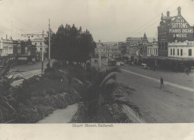
Photograph - Black and White photograph/s - mounted, late 1920's, early 1930's?
Yields information about Sturt Street east end in the late 1920's or early 1930's with motor cars and people.Black and White photograph mounted on heavy cardboard backing. Image titled "Sturt Street Ballarat", with a view from the median strip looking east with an ESCo tram at the bottom of the street. Has a number of motor vehicles in the photo, probably late 1920's early 1930's. Prominent in the photo is the store, Suttons store along with and "Indian Store", Alf Dawson - ironmonger, The Courier , and Seidel Bros shoes and boots. Has 7 Velcro dots on rear and marks where mounting devices have been removed on the rear. Note image scanned in two runs through a scanner, resulting in the shading in the image file. trams, tramways, sturt st, suttons, esco -
 Ballarat Tramway Museum
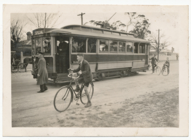
Photograph - Digital image, 28/08/1937 12:00:00 AM
Yields information about the opening of the tram line to Lydiard St North and the people who attended it.Digital image from the Wal Jack Ballarat Album of No. 32, the Official opening tram for the extension to Lydiard St North at Gregory St. Tram has been decorated for the event. Dated of photo 28-8-1937. Photographer not given, assumed the same as the other four on the album sheet. Note the boys with bicycles, school uniforms etc and the horse and buggy in the background. Wal's album notes say "No. 32 near Gregory St "Up" trip" See image i2 for rear of photograph. See image i3 for high res scan of original print and i4 for hi res scan of original negative.Has in ink on rear "(140)"trams, tramways, opening, lydiard st north, bicycles, gregory st, sec, tram 32 -
 Ballarat Tramway Museum
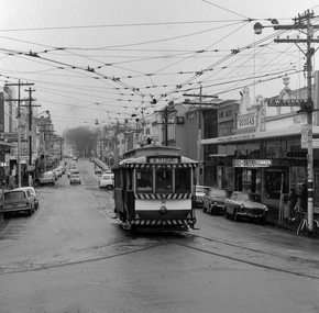
Photograph - Digital image Set of 2, Peter Bruce, "No.30 Bridge and Main", 1970s
Yields information about Bridge St Ballarat and its associated shopping strip.Digital image, black and white, two images, of No. 30 in Bridge St. 4605.1 - at Stones Corner, enroute to Mt Pleasant with Rodda's, Gill & O'Keffe, C.W. Pennan, ANZ Bank and other shops in the background. Note the signal lamps on the right hand side of the photo above the tram stop sign and how the overhead was arranged at this junction. 4605.2 - at Grenville St end, with Faulls Shoes, Suttons HMV and other shops in the background. Photo taken by Peter Bruce 1970's and 1971, prior to the closure of the Ballarat tramway system. Peter's Title of image: "No.30 Bridge and Main" and "No. 30 Bridge St up end".trams, tramways, bridge st, mt pleasant, tram 30 -
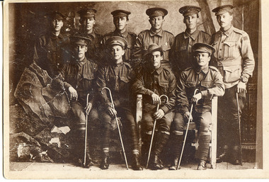 Tarnagulla History Archive
Photographic postcard - Soldiers from Tarnagulla and district, Soldiers from Tarnagulla and district, Exact date unknown, circa 1914-1918
Murray Comrie Collection.Sepia photographic postcard, with image of soldiers in uniform posed in a makeshift studio setting, with a prop boulder at left. Subjects are residents of Tarnagulla and other towns in surrounding district who served in First World War, dating the image to circa 1914-1918. Reverse is printed with postcard template. Handwritten note on reverse gives the following names: (From Left to Right) Back Row: Luther Stone, George Corrie, Cash Fitzgerald, Harry Biggs, Geo. Williamson Front Row: Bert Runting, Claude Whimpey, Bill (WIlliam) James, Bert Gray Same image as THA-2019.0026 (slight difference in names) Handwritten on reverse '1914-19 War' and 'Tarnagulla Boys' plus names.tarnagulla, waanyarra, war, military, service, soldiers, veterans, ww1, first world war, stone, corrie, fitzgerald, langan, runting, whimpey, james -
 Warrnambool and District Historical Society Inc.
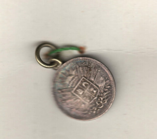
Medals, Stokes Melbourne, Industrial & Art Exhibition 1886-7, 1896
These are souvenir medals of the Warrnambool Industrial and Art Exhibition of 1896-7. This exhibition organised by a local committee under the chairmanship of the Mayor, Walter Hickford was one of the most important events in Warrnambool's history. It ran for three months and was said to have attracted 70000 visitors. It was held in Liebig Street and utilised both the civic centre buildings and temporary buildings erected for the event. It had several exhibition courts featuring art worksand business exhibition stands, competitions,entertainments and visiting experts in various fields. These medals were made at the exhibition at the stand of Stokes and Son. Visitors to the exhibition were able to get a gold silver or bronze medal made while they watched and the medal was then perforated ready to put on a watch chain or pendant. Thomas Stokes came to Australia in the 1850's and established a successful business in Melbourne manufacturing buttons, medals and tokens. The business was called Stokes and Son following a fire in 1893.These medals are of great significance as a memento of an important event in Warrnambool -The Warrnambool Industrial and Art Exhibition of 1896-7. Medals such as these would have been in the homes of many residents of Warrnambool and district and beyond after 1896..1 This silver circular medal has text around the outer rim and an image of Queen Victoria on the reverse. On the obverse is text and an image of the Warrnambool Exhibition building erected for the occasion. The medal is secured by a red thread , button and clear tape to a piece of card. On the card is a hand drawn sketch the Warrnambool Exhibition building and a hand drawn sketch of a profile of Queen Victoria . .2This silver circular medal has text around the rim and an image Warrnambool Exhibition building on the reverse and on the obverse a stylised coat of arms topped by the rising sun . Inside the field is a sailing ship, a pick and shovel , a sheep and sheaf of wheat .1 on the Reverse : around the rim, Struck at the Exhibition mint. On the obverse : Industrial exhibition 1896 Warrnambool. .2 On the obverse : Industrial exhibition 1896 Warrnambool.warrnambool, great exhibition of warrnambool, 1896 exhibition warrnambool, warrnambool exhibition medal -
 Bendigo Military Museum
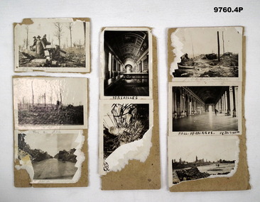
Photograph - PHOTOGRAPHS WW1
Photos from "Frederick James Baxter MC & Bar". Refer Cat No. 4219 for details.Series of small black and white photos stuck to cards relating to WW1 France Battlefield. 1. Picture of 3 ANZAC soldiers in field with 9.2 and 5.9 German shell casing. 2A. Picture of two ANZAC Soldiers in field with 9.2 shell casings and equipment. 2B. Picture of soldier on a road with ruins on either side in France. 3A. Picture of a Hall of Mirrors Versailles. 3B. Picture of unidentified ruins of a building with bomb damage. 4A. Image of bombed out battlefield with 9.2 Suzi Equip destroyed. 4B. Image of Hall of Mirrors Versailles. 4C. Image of bombed out village in France.Words unclear. 1P 9.2 and S9. 2A 9.2 Misc Ballen B. Aillea. 3A Versailles 4A. 9.2 Suzi Ballere 4B. Hall of Mirrors, Versailles.photographs, frederick james baxter, ww1, france -
 Federation University Historical Collection
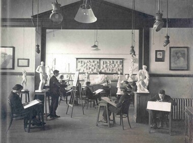
Photograph - Art class photograph, Drawing from the Antique, 1920, c1920
The large plaster Illisos depicted in the back of this image is still held by Federation University Australia. The Ballarat Technical Art School (No. 10) was part of the Ballarat School of Mines and was established in 1907. After conducting classes in various locations around Ballarat a custom built art school was erected on the site of the former Ballarat Circuit Court House, previously used as the initial building of the Ballarat School of Mines. Examples of drawings undertaken by students, as well as some plaster castes are held in the University of Ballarat Historical Collection. The Ballarat Technical art School is the oldest continuous Tertiary Art School in Australia. Sir Alexander Peacock opened the new Ballarat Technical Art School building in July 1915. It cost 10,000 pounds and was constructed by the Public Works Department from plans drawn by the then Art School Principal, Herbert H. Smith. The building contractors were Messrs Gower and Eddards. According to the SMB Annual Report of 1914 'the internal upholstering and fittings have all been carried out in Australian timbers, with Queensland maple largely used throughout.' The building could be described as federation-art deco in style. It features sandstone insertion with sandstone string coursing. The base of the building is rusticated sandstone. The building is functional in design with large metal windows in the south wall to ensure good light into the studios. The northern wall has standard double hung windows. The interior of the building features a carved wooden staircase and cast iron ceiling vents. The rear drawing studios could be made into one large studio by opening panelled timber doors. This opening features classical plaster pilasters with a pediment above. (http://guerin.ballarat.edu.au/curator/buildings/technical_art_school.shtml) Black and white mounted photograph showing eleven students of the Ballarat School of Mines Technical Art School drawing from plaster models of human bodies in various poses and of various scales. The students are in a room of the Ballarat Technical Art School which was custom built for teaching art. The image was reproduced in the 1920 Ballarat School of Mines Students' Magazine. drawing, ballarat school of mines, ballarat technical art school, art studio, plaster caste, gribble building, illisos, hercules, drawing from the antique, visual arts -
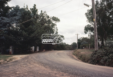
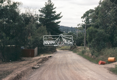 Eltham District Historical Society Inc
Slide, Adam Crescent, Montmorency, c. Feb. 1981
One of a series of images of road infrastructure focussed on Adam Crescent in Montmorency taken by Eltham Shire Council Planning and Engineering officers. They provide perspective of the changes in housing styles and road development that began sweeping in from the mid 1970s with increasing urbanisation of what was once more outlying suburbs and regions. All images have been identified with GPS though house numbers have changed35 mm colour positive transparency (1 of 21) Mount - Kodak Kodachrome CardProcessed Feb 1981adam crescent, infrastructure, montmorency, roads -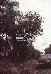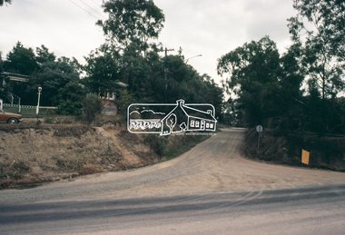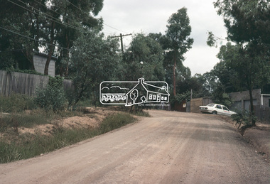
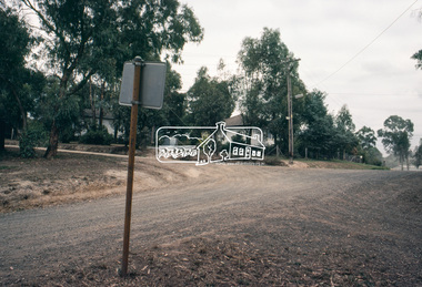
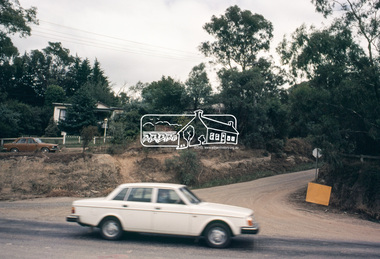
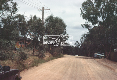 Eltham District Historical Society Inc
Slide, Adam Crescent, Montmorency, c. Feb. 1981
One of a series of images of road infrastructure focussed on Adam Crescent in Montmorency taken by Eltham Shire Council Planning and Engineering officers. They provide perspective of the changes in housing styles and road development that began sweeping in from the mid 1970s with increasing urbanisation of what was once more outlying suburbs and regions. All images have been identified with GPS though house numbers have changed35 mm colour positive transparency (1 of 21) Mount - Kodak Kodachrome CardProcessed Feb 1981adam crescent, infrastructure, montmorency, roads, gordon grove -
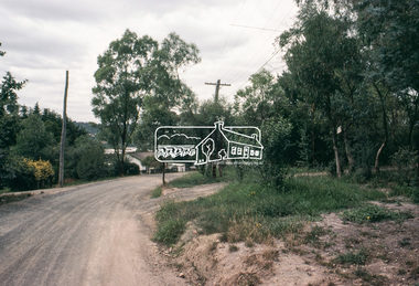
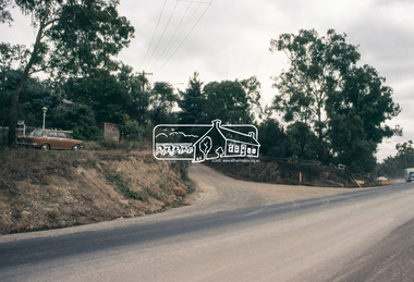
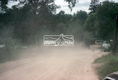 Eltham District Historical Society Inc
Slide, Adam Crescent, Montmorency, c. Feb. 1981
One of a series of images of road infrastructure focussed on Adam Crescent in Montmorency taken by Eltham Shire Council Planning and Engineering officers. They provide perspective of the changes in housing styles and road development that began sweeping in from the mid 1970s with increasing urbanisation of what was once more outlying suburbs and regions. All images have been identified with GPS though house numbers have changed35 mm colour positive transparency (1 of 21) Mount - Kodak Kodachrome CardProcessed Feb 1981adam crescent, infrastructure, montmorency, roads -
 Eltham District Historical Society Inc
Slide, Adam Crescent, Montmorency, c. Feb. 1981
One of a series of images of road infrastructure focussed on Adam Crescent in Montmorency taken by Eltham Shire Council Planning and Engineering officers. They provide perspective of the changes in housing styles and road development that began sweeping in from the mid 1970s with increasing urbanisation of what was once more outlying suburbs and regions. All images have been identified with GPS though house numbers have changed35 mm colour positive transparency (1 of 21) Mount - Kodak Kodachrome CardProcessed Feb 1981adam crescent, infrastructure, montmorency, roads, gordon grove -
 Eltham District Historical Society Inc
Slide, Adam Crescent, Montmorency, c. Feb. 1981
One of a series of images of road infrastructure focussed on Adam Crescent in Montmorency taken by Eltham Shire Council Planning and Engineering officers. They provide perspective of the changes in housing styles and road development that began sweeping in from the mid 1970s with increasing urbanisation of what was once more outlying suburbs and regions. All images have been identified with GPS though house numbers have changed35 mm colour positive transparency (1 of 21) Mount - Kodak Kodachrome CardProcessed Feb 1981adam crescent, infrastructure, montmorency, roads -
 Eltham District Historical Society Inc
Slide, Adam Crescent, Montmorency, c. Feb. 1981
One of a series of images of road infrastructure focussed on Adam Crescent in Montmorency taken by Eltham Shire Council Planning and Engineering officers. They provide perspective of the changes in housing styles and road development that began sweeping in from the mid 1970s with increasing urbanisation of what was once more outlying suburbs and regions. All images have been identified with GPS though house numbers have changed35 mm colour positive transparency (1 of 21) Mount - Kodak Kodachrome CardProcessed Feb 1981adam crescent, infrastructure, montmorency, roads, gordon grove -
 Eltham District Historical Society Inc
Slide, Adam Crescent, Montmorency, c. Feb. 1981
One of a series of images of road infrastructure focussed on Adam Crescent in Montmorency taken by Eltham Shire Council Planning and Engineering officers. They provide perspective of the changes in housing styles and road development that began sweeping in from the mid 1970s with increasing urbanisation of what was once more outlying suburbs and regions. All images have been identified with GPS though house numbers have changed35 mm colour positive transparency (1 of 21) Mount - Kodak Kodachrome CardProcessed Feb 1981adam crescent, infrastructure, montmorency, roads -
 Eltham District Historical Society Inc
Slide, Adam Crescent, Montmorency, c. Feb. 1981
One of a series of images of road infrastructure focussed on Adam Crescent in Montmorency taken by Eltham Shire Council Planning and Engineering officers. They provide perspective of the changes in housing styles and road development that began sweeping in from the mid 1970s with increasing urbanisation of what was once more outlying suburbs and regions. All images have been identified with GPS though house numbers have changed35 mm colour positive transparency (1 of 21) Mount - Kodak Kodachrome CardProcessed Feb 1981adam crescent, infrastructure, montmorency, roads, gordon grove -
 Eltham District Historical Society Inc
Slide, Adam Crescent, Montmorency, c. Feb. 1981
One of a series of images of road infrastructure focussed on Adam Crescent in Montmorency taken by Eltham Shire Council Planning and Engineering officers. They provide perspective of the changes in housing styles and road development that began sweeping in from the mid 1970s with increasing urbanisation of what was once more outlying suburbs and regions. All images have been identified with GPS though house numbers have changed35 mm colour positive transparency (1 of 21) Mount - Kodak Kodachrome CardProcessed Feb 1981adam crescent, infrastructure, montmorency, roads, sherbourne road -
 Eltham District Historical Society Inc
Slide, Adam Crescent, Montmorency, c. Feb. 1981
One of a series of images of road infrastructure focussed on Adam Crescent in Montmorency taken by Eltham Shire Council Planning and Engineering officers. They provide perspective of the changes in housing styles and road development that began sweeping in from the mid 1970s with increasing urbanisation of what was once more outlying suburbs and regions. All images have been identified with GPS though house numbers have changed35 mm colour positive transparency (1 of 21) Mount - Kodak Kodachrome CardProcessed Feb 1981adam crescent, infrastructure, montmorency, roads, sherbourne road