Showing 8584 items
matching melbourne trams
-
 Greensborough Historical Society
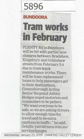
Newspaper Clipping, Diamond Valley Leader, Tram works in February, 23/01/2019
Plenty Road in Bundoora will be hit with partial lane closure between Bradshaw, Kingsbury and Grimshaw Streets from February 2-4 (2019) due to tram track maintenance works.News article 1 page, black text.plenty road bundoora, closure, tram track maintenance works, public transport -
 Greensborough Historical Society
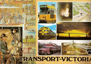
Book, Transport in Victoria, 1980s
Each of these booklets details the history, changes and upgrades to transport in Victoria in the early 1980s and explains the role af government authorities such as the Country Roads Board. Item 707c describes the Melbourne Freight Terminal between Spencer Street and Footscray Road.An historical look at the development of transport in Victoria.A collection of 3 booklets on transport in Victoria. Item 707a: 16 pages, colour illustrations. Item 707b: 20 pages, colour illustrations.Item 707c: 8 pages, black and white illustrations (20 x 14.5 cm). railways, transport, victoria, trams, roads -
 Greensborough Historical Society
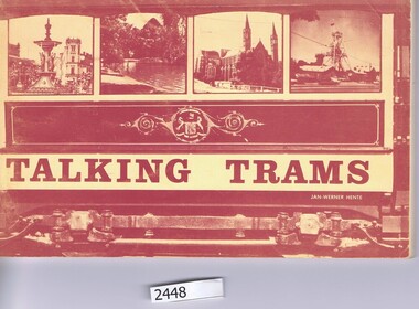
Book, Bendigo Trust Ltd, Bendigo's talking trams, present past and future, 1973_
A guide and history of the 'talking' trams of Bendigo, Victoria.Description of Bendigo's tram fleet and commentary on the "Talking Tram " route.96 p., illus.trams, bendigo -
 Greensborough Historical Society
Photograph - Digital image, Charles Marshall et al, Port Said Tramway 2, 1917-1918
This photograph shows the tramway at Port Said. This photo was sent to Charles' brother Gillie.Digital copy of black and white photograph. "For Gillie, Port Said Tram service"charles marshall, world war 1 -
 Greensborough Historical Society
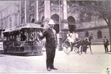
Photograph - Digital Image, Victorian Policeman on Point duty in Swanston Street 1930s, 1930s
Digital copy of one of 7 slides depicting photographs of police from 1858 to 1930s. This image is of an officer on traffic duty at the Melbourne Town Hall, Swanston Street, with the Toorak tram in background.Digital copy of black and white slide.victoria police, melbourne town hall -
 Victoria Police Museum
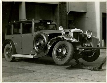
Photograph (police car), Kodak
Daimler registration number 2-690 on hoist with damage to front right hand side mudguard and wheel, circa 1935No 140. No. 2 Daimler. Reg No. 2-690. Accident 23.5.35. Driver - H.V. Casey 8770. Struck a trampolice vehicles; transport; motor police branch; daimler car; wireless patrol -
 Victoria Police Museum
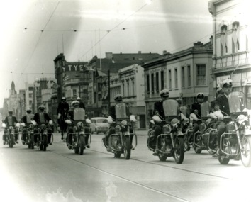
Photograph (police motorcycle)
Motorcycle police riding Ariels along tram tracks with two mounted police to the rear of the photographpolice vehicles; wireless patrol; motor transport branch; motor transport section; motor cycle patrol; police motorcycles; ariel motorcycle -
 Eltham District Historical Society Inc
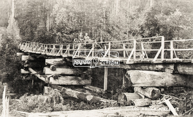
Negative - Photograph, Log bridge over Pheasant Creek, Kinglake, c.1920
Reproduced on p74 of 'Pioneers & Painters' Driver is Mr. F. Thomson, brother of Mrs McMinn. The timber tramway bridge was built by Mr. Munro, owner of the saw mill. The wooden tram rail ran from the timber logging site to saw mill to Whittlesea.Roll of medium format 120 6x6 black and white negative film, 4 framesAgfa APX 100shire of eltham pioneers photograph collection, bridge, f. thomson, kinglake, log bridge, mr. munro, pheasant creek, pioneers and painters, timber tramway -
 Glen Eira Historical Society
Album - Album page, Grimwade House, Orrong Road, Circa 1972
This photograph is part of the Caulfield Historical Album 1972. This album was created in approximately 1972 as part of a project by the Caulfield Historical Society to assist in identifying buildings worthy of preservation. The album is related to a Survey the Caulfield Historical Society developed in collaboration with the National Trust of Australia (Victoria) and Caulfield City Council to identify historic buildings within the City of Caulfield that warranted the protection of a National Trust Classification. Principal photographer thought to be Trevor Hart, member of Caulfield Historical Society. Most photographs were taken between 1966-1972 with a small number of photographs being older and from unknown sources. All photographs are black and white except where stated, with 386 photographs over 198 pages. From Victorian Heritage Database citation HO54 Grimwade House, former Harleston stables, outbuilding, garden, gate and Picconia excelsa tree. https://vhd.heritagecouncil.vic.gov.au/places/35573 as at (28/10/2020) ''Harleston'', now "Grimwade House", is situated at no. 67 Balaclava Road, Caulfield North, at the Orrong Road corner. It was built for Frederick, later Sir Frederick, Grimwade, to the design of architect Thomas Watts in 1875. Today the complex has been incorporated in the Melbourne Grammar Junior School campus. It retains not only the main house but also the stables and mature garden setting with driveway and gates. It is historically, aesthetically and socially significant.From Victorian Heritage Database citation HO54 Grimwade House, former Harleston stables, outbuilding, garden, gate and Picconia excelsa tree. https://vhd.heritagecouncil.vic.gov.au/places/35573 as at (28/10/2020) It is historically significant (Criterion A) as the former home of prominent business man, speculator and benefactor, Sir Frederick Grimwade. Both Grimwade and his house are exemplars of the commercial enterprise of the Boom period and the amassing of personal fortunes with which it is associated. It is aesthetically significant (Criterion E) as an imposing yet stately large house of its time, the classic Italian form with comer verandah terminated by projecting wings being most distinctively seen in this instance. It is enhanced not only by the garden setting but also by the delicate cast iron verandah spandrels, stained glass work and stencilled ceiling in the music room. It is socially significant (Criterion G) on account of the value placed on it by the community associated with the Melbourne Grammar Junior School since its inception on this site in 1911.Page 154 of Photograph Album with five photographs (4 landscape and one portrait) including Grimwade House, gates and a tram shelter.Handwritten: Grimwade House (Melbourne Grammar Prep School) / incorporating "Harleston" Orrong Rd. S.E cnr Balaclava Rd [top right] / 154 [bottom right]trevor hart, verandah, porch, slate roof, garden, grimwade house, grimwade, harleston, sir frederick grimwade, thomas watts, orrong road, balaclava road, melbourne grammar, melbourne grammar junior school, italianate, cast iron verandah spandrels, stained glass, stencilled ceiling, mgs, m.g.s, school, grimwade family, jessie grimwade, gates, palisade style fence, cast iron spears, stone plinths, melbourne grammar prep school, victorian style, cast iron work, caulfield north, gardens, cars, tram services, outbuildings, stables, trees, picconia excelsa tree -
 Glen Eira Historical Society
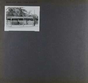
Album - Album page, Balaclava Road Tram Shelter, Circa 1972
... and is one of only three remaining tram shelters in Melbourne... and is one of only three remaining tram shelters in Melbourne ...This photograph is part of the Caulfield Historical Album 1972. This album was created in approximately 1972 as part of a project by the Caulfield Historical Society to assist in identifying buildings worthy of preservation. The album is related to a Survey the Caulfield Historical Society developed in collaboration with the National Trust of Australia (Victoria) and Caulfield City Council to identify historic buildings within the City of Caulfield that warranted the protection of a National Trust Classification. Principal photographer thought to be Trevor Hart, member of Caulfield Historical Society. Most photographs were taken between 1966-1972 with a small number of photographs being older and from unknown sources. All photographs are black and white except where stated, with 386 photographs over 198 pages. From Victorian Heritage Database citation H0174 TRAM VERANDAH SHELTER CORNER BALACLAVA AND ORRONG ROADS CAULFIELD NORTH - Vic Heritage Register https://vhd.heritagecouncil.vic.gov.au/places/2721 (as at 28/10/2020) The waiting shelter at the corner of Balaclava Road and Orrong Road, Caulfield was constructed in 1916/17 for the Prahran and Malvern Tramways Trust and is one of only three remaining tram shelters in Melbourne designed in the form of a verandah. The shelter has a corrugated iron roof fixed to an angle iron roof frame. The roof, which extends in the form of a skillion over the pavement, is supported on three squared, chamfered timber posts at the rear and three cast iron reeded columns with round bases and Corinthian capitals at the front. (The columns are hollow and function as downpipes, with rainwater discharging from the verandah roof, through the columns and under the ground). The shelter has a rinceau pattern frieze along the road frontage with centrally placed shield motif (which does not contain a coat of arms). The side and rear panels are lined with ripple iron and the upper panel at the rear is lattice work. The shelter has two timber slatted bench seats.From Victorian Heritage Database citation for H0174 TRAM VERANDAH SHELTER CORNER BALACLAVA AND ORRONG ROADS CAULFIELD NORTH - Vic Heritage Register https://vhd.heritagecouncil.vic.gov.au/places/2721 (as at 28/10/2020) How is it significant? The waiting shelter at the corner of Balaclava Road and Orrong Road, Caulfield is of historical and architectural significance to the State of Victoria. Why is it significant? The waiting shelter is of historical significance for its association with the development of the suburban (electric) tram network which assisted the expansion of Melbourne as a suburban metropolis. It is also of historical significance for its connection with the Prahran & Malvern Tramways Trust. The Prahran & Malvern Tramways Trust (1907-1920) was the first municipal electric tramway in Melbourne, becoming the largest and most successful of all the municipal tramway trusts. Its services played a key role in facilitating suburban expansion and the development of the southern and eastern suburbs. The growth of tramways was one of the greatest municipal developments in Victoria during the first decade of the twentieth century. The waiting shelter is an important remnant of this period of Melbourne's transport history and a tangible reminder of the Prahran & Malvern Tramways Trust. The shelter indicates the extent of the Prahran & Malvern tram network. The waiting shelter at corner of Balaclava Road and Orrong Road, Caulfield is one of only three remaining tram shelters in Melbourne designed in the form of a verandah. The waiting shelter is of architectural significance for the distinctive design and construction which is unique to the Prahran & Malvern Tramway Trust tram network. The shelter was designed by notable Melbourne architect Leonard J. Flannagan (1864-1946). Flannagan was responsible for a number of buildings for the Prahran and Malvern Tramways Trust including the early waiting shelter at the junction of Dandenong Road and Hawthorn Road, Caulfield, and sections of the tram depot at Malvern, and also designed a depot for the Hawthorn Tramways Trust. The waiting shelter, a conservative design influenced by Victorian architecture, is based on the Melbourne City Council late 19th century standard cast iron verandah. It is of significance as an intact example of the cast iron type shelter and for its detail, including Corinthian columns and a 'rinceau' pattern cast-iron frieze. The shelter is largely in keeping with the original design and retains its integrity. The cast iron waiting shelter is also of significance as an unusual example of early twentieth century street architecture. Page 155 of Photograph Album with one landscape photograph of a tram shelter on Balaclava Road.Handwritten: BALACLAVA ROAD TRAM SHELTER [top] / 155 [bottom left]trevor hart, verandah, garden, grimwade house, grimwade, orrong road, balaclava road, melbourne grammar, melbourne grammar junior school, mgs, m.g.s, school, tram shelter, waiting shelter, prahran & malvern tramway trust, leonard j. flannagan, cast iron verandah, cast iron type shelter, corinthian columns, 'rinceau' pattern cast-iron frieze, rinceau, cast iron frieze, victorian style, caulfield north, leonard flanagan, cast iron work, prahran and malvern tramways trust, trams -
 Glen Eira Historical Society
Document - PRAHRAN AND MALVERN TRAMWAYS TRUST
This file has 3 items. 1/Photocopy of Caulfield Conservation Study Report by Andrew Ward dated January 1995 of 6-8 Rusden Street, Elsternwick being former Prahran and Malvern Tramways Trust substation. Report includes image, existing registrations, description of substation building and condition. 2/Original photograph (black and white) of tram shelter at corner of Balaclava Road and Orrong Road, Caulfield North, outside Grimwade House (school), description written on back of photo. 3/Original copy of magazine of the Tramway Museum Society of Victoria Ltd. ‘Running Journal’ Vol 7 No. 3 dated June 1970. Article (pages 3-7) entitled ‘Feeding & Filling, The Story of the Prahran & Malvern Tramways Trust’ written by Graeme Breydon. Article written for the 60th anniversary of the trust which opened for business on 30/05/1910 and describes the establishment and development of Tramways between suburbs of Malvern & Prahran including Elsternwick, Caulfield & Glen Huntly. Article includes 4 images plus map and diagram. Included: Photograph 3: Opening ceremony of tramway extension from Balaclava junction to Elsternwick railway station on Glen Huntly Road dated 13/11/1913. Diagram of various tramway routes including Prahran & Malvern Tramways Trust routes.prahran and malvern tramways trust, p+mtt, tram companies, land transport, public transport, substation, tram shelter, powerhouse, parapet, brick, stuccoed, roof lanterns, historic buildings register, national estate register, national trust register, rusden street, balaclava road, orrong road, hawthorn road, dandenong road, glen huntly road, grange road, elsternwick, elsternwick railway station, caulfield, caulfield north, caulfield railway station, point ormond, grimwade house, breydon graeme, tramcar, edwardian, transport, trams, tram depot -
 Glen Eira Historical Society
Article - TRAMWAYS IN GLEN EIRA
... , 16 June 1928’, listing by tram depot (2 pages); ‘Melbourne... VIC 3162 melbourne Contains 9 items: 1/Typed statements from ...Contains 9 items: 1/Typed statements from Keith Stodden, dated 03/09/2004, contributing his list of tram routes in Glen Eira from 1920-1970 and 1970-2004. 2/’Trams in Glen Eira (Caulfield) – A Time Line History’, by Keith Stodden, dated 03/09/2004, listing opening and conversion dates and a detailed time-line from 1888 through 1995, of tram lines in Glen Eira (7 typed pages). Included is Mr Stodden’s handwritten draft of this time-line (13+2 pages). 3/’Trams in Glen Eira, notes prepared by Keith Stodden’, dated 27/05/2004, briefly describing tram routes in Glen Eira (2 pages). 4/Page from unnamed Melbourne newspaper (dated December 1895 in pen) with advertisement for tendering for lease of property for Caulfield Tramway. 5/’Our Tramways’, photocopy of cutting from unnamed newspaper, hand dated 1913, about recent developments on Melbourne tramways. 6/’Melbourne and Metropolitan Tramways Board, location of cars at end of 28 day period, 16 June 1928’, listing by tram depot (2 pages); ‘Melbourne and Metropolitan Tramways Board, location of cars at end of 28 day period, 9 June 1934’, listing by tram depot (2 pages); ‘Melbourne and Metropolitan Tramways Board, location of cards at end of financial year, 30 June 1938’, listing by depot (2 pages). 7/’Glenhuntly Road’, cutting from Southern Cross newspaper, dated 14/05 but without the year (perhaps 1980), with brief history of Glenhuntly Road and photograph of first electric tram there, April 1913. 8/Flyer (2 pages) for ‘The Tramway Society of Victoria Ltd’, about the history of the Society (undated). 9/’Caulfield Conservation Study-Tramways Reservation-Dandenong Road’, photocopied description (5 pages) of reservations in the centre of Dandenong Road, with photographs. Assessment and one photograph dated March 1994.tram services, tram depots, trams, glen eira, caulfield, transport, glen huntly road, leslie street, elsternwick, hawthorn road, grange road, dandenong road, derby road, carnegie, balaclava road, stodden keith, glen huntly depot, caulfield tramway, elsternwick, watts thomas, elstercreek, architectural features, flannagan leonard j., ward andrew, tram companies, land transport, tram shelter -
Glen Eira Historical Society
Photograph - TRAMWAYS IN GLEN EIRA
Three downloaded photographs of trams in Glen Eira: 1/Photocopy of photograph of ‘New Electric Cars (ie trams), Elsternwick Victoria 1913’, reproduced from Howard Bruce, Romance of Australia Trams Photograph Collection c.1870-1976. 2/Untitle photocopy of photograph of trams and crowd, taken on 13/11/1913 (handwritten date) – presumedly of the new electric trams in No.3, above. No specific source mentioned. (National Library of Australia? (dated 27/11/2011) 3/Photocopy of postcard of ‘Glen Huntly Road, Elsternwick’ handwritten ‘c.1913’, from State Library of Victoria (dated 13/01/2012).trams, elsternwick, glen huntly road -
Glen Eira Historical Society
Document - LAND SUBDIVISIONS 1880-1938
This file contains various subdivisions’ advertising flyers and cards. 1/Advertising announcement for auction sale of land (15 lots) at Glenhuntly Tram Terminus, to be held on 29/03/1924. Verso is map of the area (21.5cm x 29cm) 2/Advertising announcement for Trustees’ Auction sale of corner shop sites at Caulfield South near Glenhuntly Road and Hawthorn Roads, 15/11/1927 (21cm x 31cm) 3/Advertising pamphlet (A3) for auction of Cantala Estate, East St. Kilda (32 allotments), between Dandenong, Waiora, and Alma Roads, 21/05/1938 (15.5cm x 28.5cm) 4/Seven advertising postcards relating to auctions of land in Caulfield and Elsternwick. Only one (10 December 1881) with a year on it. (Each 13.5cm x 9cm) 5/Four more advertising postcards relating to auctions of land in Caulfield. One is dated 31/11/1880(?); another 09/02/1905. A third has no date. A fourth postcard is a map of allotments between Orrong, Kooyong, Seymour and Alison Roads, Caulfield, no date (each 13.5cm x 9cm) 6/Large advertising poster (41cm x 52.5cm) for ‘Carnegie Land Sale’ auction of the Egan Estate (near Carnegie Railway Station) on 12 April, no year given, but appears to be circa1900 7/‘Riddell Estate – Plan of Subdivision – Parish of Prahran’ mounted map, no date, probably c. 1900 (16cm x 21cm)auctions, house auctions, land subdivision, land development, subdivisions, caulfield, land subdivisions, east st. kilda, glenhuntly, carnegie, map, ‘new glenhuntly tram terminus estate’, ‘cantala estate’, ‘strathnaver estate’, ‘range estate’, ‘egan estate’, ‘riddell estate’ -
Glen Eira Historical Society
Document - TOURS
There are two copies of the Discover Caulfield guide produced by the Caulfield Historical Society. One from 1982 which contains twelve pages, seven of which are typed and the last five a continuation of the guide added later, hand-written. The other is a modern typed version of the same document. They both detail a pictorial tour of the mansions and gardens in the City of Caulfieldcaulfield, mansions, gardens, homes, ‘lirrewa’, lirrewa grove, caulfield city hall, smith sydney, ‘halstead’, bambra road, halstead road, caulfield historical society, messrs. upton and smith, civic establishments, dickson james dr., houses, national trust, st. stephen’s church, balaclava road, gothic (revival) architecture, messrs. haddon and henderson, st. aloysius, archbishop of melbourne mannix dr., caulfield park, hawthorn road, inkerman road, kambrook road, paddy’s swamp, cannizzo philip, caulfield city council, trams, orrong road, grimwade house, ‘harleston’, grimwade frederick sheppard, primary schools, caulfield art centre, ‘stanmark’, art galleries, ‘craigellachie’, person william, pearson eliza, francis newton mr., greenmeadows gardens, milburn grove, greenmeadows house, lempriere john, mayors, ‘glenfern’, boyd john captain, boyd martin, ‘myoora’, alma road, ‘bagatelle’, christian thomas, henderson anketell, flats, building construction, ‘burreel’, kooyong road, burreel avenue, francis john, stephen sidney, allan george l., ‘royston’, renwick s. mrs., sargood frederick sir., ‘glen eira’, ricketson henry, caulfield hospital, royal southern memorial hospital, caulfield general medical centre, ‘ripponlea’, reed and barnes, architects, towers, rippon emma, rippon thomas, guilfoyle william, employees, ‘the village houses’, regent street, st. george’s road, cottages, bent thomas sir., jones louisa mrs., nathan benjamin, ‘anselm’, glenferrie street, queen anne style, haddon robert, historical buildings, princes’ park, ‘glenmore’, watts thomas, more hugh, glenhuntly road, gates, villas, ‘hopetoun’, hopetoun street, webb charles, hopetoun hospital, harleston park, allison street, langdon montague, langdon harry joseph, ‘tarqua’, ‘labassa’, manor grove, koch john, robertson a. w., wagner john, ‘ontario’, trinity congregational church, grange road, glen huntly, churches, greek orthodox church, ‘fairfield hall’, north road, younger james, glenhuntly post office, smith alfred, smith anne, methodist church, ‘lambros the cobbler’, railways, ballantyne r., snowball betty, kahlyn private hospital, ‘kynaston’, st. mary’s jubilee school, festivals and celebrations, st. mary’s anglican church, church of england, bishop moorhouse, joynt donoman, elsternwick post office, elsternwick, elsternwick bowling club, elsternwick rsl, caulfield grammar school, davis henry rev., selwyn street, elsternwick railway station, glen eira road, barnett r. j. rev., tudor court, world war 1914-1918, ‘fairhaven’, hope george, caulfield library, plaques, cannons, ‘janvec joinery’, parkside street, ‘parkside court’, clarence street, ‘streetscene’, grange road, greenhouses, vallati gladys -
Glen Eira Historical Society
Letter - Whittaker, G, Mrs
File contains 2 items: 1/ A handwritten letter by Mrs G. Whittaker on her personal memories/recollections of South Caulfield, which includes neighbours’ transport, homes, businesses and properties, some of which may have been included in ‘Sand, Swamp and Heath’ by Murray and Wells. 2/ Handwritten research note dated 27/09/2013 by Peta Darke concerning Mrs Whittaker’s parents’ house.whittaker g mrs, caulfield, flowers street, council employees, caulfield council, chinese community, market gardens, quong sing, bealiba road, trams, bambra road, glenhuntly road, glen huntly road, pearce’s nursery, nurseries, pearce mr, prisoners, pearce street, chloris street, benbow family, griffiths brothers teas, griffiths street, longs bull paddock, long mr, methodist church, hawthorn road, camden town methodist, mcconchie harry, mcconchie cricket ii, glenhuntly road, camden court, freeman street, lomax frederick, chloris park -
Glen Eira Historical Society
Document - Glenhuntly Park Estate
This file contains three items: 1/Photocopy (2 pages) of plan for Glenhuntly Park Estate, showing Lyons and Morgan Streets. Includes photocopied photos of Glenhuntly shopping strip in Glenhuntly Road. 2/Photocopy (2 pages) of advertisement for Glenhuntly Park Estate. Includes photocopied photos of Carnegie and Glenhuntly shopping strips. 19/03/1988. 3/Photcopy (2 pages) of plan for Glenhuntly Park Estate; includes Miller and Morgan Streets. Also photocopied photo of Miller Street.glenhuntly park estate, glenhuntly road, lyons street, morgan street, moira avenue, koornang road, miller street, neville street, caulfield, glenhuntly, carnegie, elsternwick, land subdivision auctions, villas, trams, plans, estate, messrs robert best & hooper solicitors -
 Glen Eira Historical Society
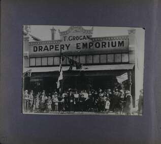
Album - Album page, Glen Huntly Road, Circa 1972
This photograph is part of the Caulfield Historical Album 1972, showing a crowd gathered in front of T Grogan's Drapery Emporium, entitled "6: Opening Day Glen Huntly Road Electric Trams 13.11.12". This album was created in approximately 1972 as part of a project by the Caulfield Historical Society to assist in identifying buildings worthy of preservation. The album is related to a Survey the Caulfield Historical Society developed in collaboration with the National Trust of Australia (Victoria) and Caulfield City Council to identify historic buildings within the City of Caulfield that warranted the protection of a National Trust Classification. Principal photographer thought to be Trevor Hart, member of Caulfield Historical Society. Most photographs were taken between 1966-1972 with a small number of photographs being older and from unknown sources. All photographs are black and white except where stated, with 386 photographs over 198 pages.Page 71 of Photograph Album with one photograph (in portrait) from Glen Huntly Road taken circa 1912. Hand written: 71 [bottom left] // title on photograph " 6: OPENING DAY GLEN HUNTLY ROAD ELECTRIC TRAMS 13.11.12"trevor hart, glen huntly road, elsternwick, shops, electric trams, crowds, buildings, flags, victorian, opening day, celebrations, glenhuntly road, t grogan's drapery emporium, clothing shops, openings (events), t grogan -
 Federation University Historical Collection
Photograph - Photograph - Black and White, Photographs of Ballarat Buildings by Geoff Biddington, 1967, 1967
... and Bridge 40. Hepburn Graveyard, Smeaton 41-45 - Ballarat Tram Ride.... Taking up the Ballarat Tram Tracks, 1967 .49. Melbourne House ...Geoff Biddington took numerous photos around Ballarat and District. He was an active member of the Ballarat Branch of the National Trust. 48 black and white photographs of Ballarat buildings. 1. National Bank, Buninyong 2. Gas Light Standard, Geelong Road, Mount Clear 3. Water Hydrant 4. Former Police Station, Camp Street 5. Cast Iron Drinking Fountain, Eureka Stockade 6. Buninyong Gold Discovery Monument 7. Ballarat Old Cemetery Gates 8. Ballarat East Post office 9. Carriers Arms, Doveton Street North 10. North Star Hotel, Lydiard Street North 11.Lake View Hotel 12. Former Ballarat Gaol, Gate Two 13. Beaufort House 14. Smythesdale Post Office 15. Ballan Timber Building 16. National Mutual Building, Sturt Street 17. Craig's Hotel Doors 18. Her Majesty's Theatre Stage 19 & 20. Ballarat Botanical Gardens Statuary House 21 & 22. Stonemason at work 23. Methodist Church School (1867) Humffray Street 24 & 25. Methodist Church, Brown Hill 26. Queen St Statue,Sturt Street 27-29. Sturt Street Fountain 30. Moore Statue, Sturt Street 31. Hede Statue, Sturt Street 32. George V Statue (Victor Greenhalgh), Sturt Street 33-35. Peter Lalor Statue, Sturt Street 36. Art Deco Statue, Sturt Street 37. Beaufort Bandstand 38. Ranger Barracks, Curtis Street, Ballarat 39. Smeaton Mill and Bridge 40. Hepburn Graveyard, Smeaton 41-45 - Ballarat Tram Ride (possibly last) 46-48. Taking up the Ballarat Tram Tracks, 1967 .49. Melbourne House, Sebastopolgeoff biddington, biddington, buninyong, mount clear, police, gold, cemetery, hotels, ballarat gaol, beaufort house, smythesdale, ballan, theatre, statue, statues, statuary, peter lalor, ranger barracks, smeaton mill, smeaton bridge, hepburn, tram, sebastopol, craig's, her majesty's theatre, smeaton, hepburn graveyard, gold monument, queen victoria statue, ballarat, foodland, ballarat, ballarat buildings, former eagle hotel, former ballarat police station, gold discovery, craig's hotel, buninyong gold discovery obelisk -
 Federation University Historical Collection
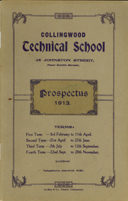
Booklet, Collingwood Technical School Prospectus, 1913, 1913
In the early years of the 20th century adequate technical education was lacking and became a focus in the Victorian Parliament. After much debate and discussion among politicians and educationalists, the 1910 Education Act No 2301 was passed, making possible the establishment of new technical schools to address the dearth of skilled trades people. In July 1912 Collingwood Technical School opened in the modified bluestone buildings at 35 Johnston St, originally built in 1853 as the Collingwood Town Hall and Court House. Within three weeks, there were 57 boys enrolled - studying preliminary carpentry and pattern-making, plumbing, engineering, sheet iron work and bricklaying. They attended two hours a night on three evenings a week. In 1913, the school opened its doors to juniors and took residence in new permanent buildings erected on the site. It was classified as a trades school by the State Education Department. Two years later courses in electrical wiring and electrical and mechanical engineering were introduced. In 1988 Preston College of TAFE and Collingwood College of TAFE merged to become Northern Metropolitan Institute of TAFE (NMIT). (http://victoriancollections.net.au/organisations/northern-melbourne-institute-of-tafe)Brown soft covered booklet of 40 pages. The contents include information relating to the Collingwood Technical School on 1913, including: Council members, constitution, standing orders, aim of the school, scholarships, advice to parents, Railway Fares, tram fares, General Rules to Students, Syllabus, English, Geography, Civics, Mathematics, Elementary Science, Woodwork, |Sheetmetalwork, evening course, carpentry, plumbing, joinery, and a list of students for 1912 Evening courses. collingwood technical school, collingwood, tafe, nmit, northern metropolitan institute of tafe -
 Federation University Historical Collection
Booklet, Collingwood Technical School Prospectus, 1914, 1914
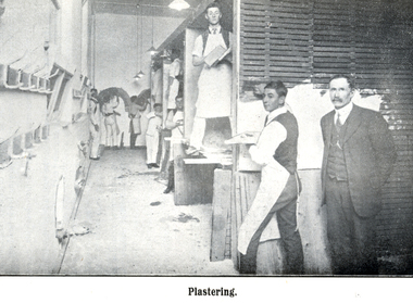
In the early years of the 20th century adequate technical education was lacking and became a focus in the Victorian Parliament. After much debate and discussion among politicians and educationalists, the 1910 Education Act No 2301 was passed, making possible the establishment of new technical schools to address the dearth of skilled trades people. In July 1912 Collingwood Technical School opened in the modified bluestone buildings at 35 Johnston St, originally built in 1853 as the Collingwood Town Hall and Court House. Within three weeks, there were 57 boys enrolled - studying preliminary carpentry and pattern-making, plumbing, engineering, sheet iron work and bricklaying. They attended two hours a night on three evenings a week. In 1913, the school opened its doors to juniors and took residence in new permanent buildings erected on the site. It was classified as a trades school by the State Education Department. Two years later courses in electrical wiring and electrical and mechanical engineering were introduced. In 1988 Preston College of TAFE and Collingwood College of TAFE merged to become Northern Metropolitan Institute of TAFE (NMIT). (http://victoriancollections.net.au/organisations/northern-melbourne-institute-of-tafe)Red soft covered book of 60 pages. Contents include: List of President, Council and staff, constitution, aim of the school, scholarships, evening classes, advice to parents, Railway fares, tram fares, free travel, general rules for students. syllabus of work, evening work. Images include carpentry class, Bricklaying, plastering and Turning & Fitting classcollingwood technical school, collingwood, tafe, nmit, northern metropolitan institute of tafe, carpentry, bricklaying, plastering, turning and fitting -
Federation University Historical Collection
Booklet - Booklet - Prospectus, J. Kemp, Melbourne Junior Technical School, Prospectus, 1912, 1912
Used at Ballarat School of Mines and Industries. The Melbourne Junior Technical School opened in 1912. It was a School for Junior Technical Work in Science, Art and Trade. This Prospectus gives information about the aim of school, courses of study, scholarships, standards of admission, holidays, evening classes, regulations, rules, sports, staff, advice to students and parents, railway and tram fares and syllabuses of work. As this was the first year of the School, Staff were introduced and their previous positions were detailed. Head Master was Mr P McCormick who had been head of the Junior Technical School at the Working Men's College. The Senior Master was Mr Bruce who had also been at the Working Men's College. Mr Hauser was selected for his position at the Education Department and would be the English Master. Mr Gilmore was the Art Master and had been at the Working Men's College. Mr Lewis was appointed Mathematical Master. He was a graduate from Melbourne University. The Science Master was Mr R A White and was an instructor at the Junior Technical School, Bendigo School of Mines and Industries. As well as these members of staff there was a competent staff of assistants.Grey soft covered booklet with information about admissions, aim of the school, courses of study, enrolment, fees, scholarships, staff, syllabuses and subjectsmelbourne, melbourne junior technical school, prospectus, 1912, science, art, trades, scholarships, evening classes, syllabuses, working men's college, bendigo school of mines and industries, head master, p mccormick, senior master, mr bruce, english master, mr hauser, education department, art master, mr gilmore, mathematical master, mr lewis, melbourne university, r a white, bendigo junior technical school -
 Federation University Historical Collection
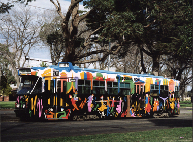
Photograph, "Melbourne Now" Art Tram, c1991
... "Melbourne Now" Art Tram ...melbourne tram...Photograph of an art tram with the words "Melbourne Now" on it. ... design art tram melbourne tram transport Photograph of an art ...Photograph of an art tram with the words "Melbourne Now" on it. graphic design, art tram, melbourne tram, transport -
 Federation University Historical Collection
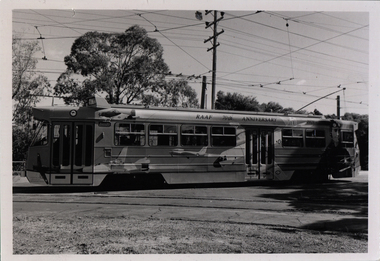
Photograph - Colour, "RAAF 70th Anniversary" Art Tram, 1991, 1991
... melbourne tram... design art tram melbourne tram royal australian air force ...Black and white photograph of an art tram with the words "RAAF 70th Anniversary" on it. graphic design, art tram, melbourne tram, royal australian air force, anniversary -
 Federation University Historical Collection
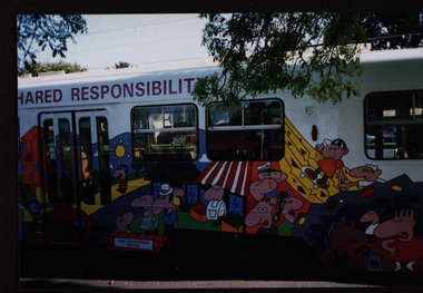
Photograph - Colour, Art Tram by Ballarat University College Student, 1991, 1991
... melbourne tram... design art tram melbourne tram royal australian air force ...Colour photographs of an art tram by Mark Lycette, a Graphic Design Student at Ballarat University College. The tram includes the words "Crime Prevention - A Shared Responsibilty"graphic design, art tram, melbourne tram, royal australian air force, anniversary, mark lycette, alumni, police, crime prevention, crime stoppers -
 City of Moorabbin Historical Society (Operating the Box Cottage Museum)
Newsletter, City of Moorabbin Historical Society Jun 2008, June 2008
The City of Moorabbin Historical Society was formed c 1960 by a group of Moorabbin residents who were concerned that the history of the area should be preserved. A good response to a call for items related to the historical area of Moorabbin Shire brought donations of a wide variety of artefacts which are now preserved by the current members of CMHS at Box Cottage Museum . Helen Stanley, Secretary of CMHS, began producing a Newsletter for members in April 2007 to provide current information and well researched items of historical interest.Helen Stanley has produced a bi-monthly Newsletter, 2007 - 2013, for the members of the City of Moorabbin Historical Society that contains well researched interesting historical items, notification of upcoming events, current advice from Royal Australian Historical Society , Museums Australia Victoria and activities of Local Historical Societies. The Newsletter is an important record of the activities of the CMHS. Tom Sheehy, past President of CMHS, was an Historian and Author of ‘Battlers Tamed the Sandbelt’. A4 paper printed both sides x1. Issue 7 of the bi-monthly, City of Moorabbin Historical Society Newsletter produced by Society member and Secretary, Mrs Helen Stanley in June 2008. Notice for meeting June 29th and August 31st at which Ms Dorothy Booth’s topic will be ‘The Historical Mentone Railway Gardens’. Another excerpt from the CMHS Newsletter November 1965, by Tom Sheehy, President, called ‘Memories of Old Cheltenham’ This is the story ‘as told’ to Tom Sheehy by Jack McCarthy b 1890, a member of CMHS, and includes a photocopied photograph of passengers on SS Hygeia c 1900 on a trip across the Bay to the Geelong area. CITY of MOORABBIN HISTORICAL SOCIETY / JUNE 2008 NEWSLETTERcity of moorabbin historical society, stanley helen, melbourne, moorabbin, brighton, chelsea, cheltenham, ormond, bentleigh, market gardeners, pioneers, early settlers, moorabbin shire, sheehy tom, box cottage museum, highett, cheltenham railway station victoria, mccarthy jack, power maurice j., charman road state school, standard certificate education, cheltenham post office, point nepean road, sports, moorabbin show, processions, parades, mentone ice skating rink, sheperd’s café, bourke street, horse tram, sandringham, beach road, ss hygeia, ss courier, ss edina, mechanics hall, memorial hall, magic lantern shows, crooks mr., engine drivers strike 1903, park road cheltenham, booth dorothy, mentone railway station gardens -
 City of Moorabbin Historical Society (Operating the Box Cottage Museum)
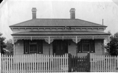
Photograph - Photograph, 4 Vickery Street Bentleigh c 1950, 1950
Mr John Herron and his wife Isa Mary Herron purchased the house at 4 Vickery Street Bentleigh in 1950 from Miss M Marriott. Isa May (nee Kennedy) was the granddaughter of James Jones a very early settler in Moorabbin Shire and Miss M Marriott was a descendant of the early settler market gardeners Marriott family. Mr Herron lived there until 1989 and the house was demolished and turned into a carpark for the busy Shopping precinct of Centre Road, Bentleigh. The Marriott family were early settler market gardeners from 1878 in the area of Dendy’s 1841 Special Survey. Isa May Jones, the grand daughter of James Jones married John Herron in 1940. James was the son of Philip Jones , a chair-maker, who settled in the area of East Brighton, now Bentleigh, in 1852. John Herron immigrated to Australia in 1926.A black and white photograph of the house at 4 Vickery Street, Bentleigh purchased by Mr John Herron and his wife Isa May (nee Jones) in 1950 from Miss M. Marriott. * pioneers, early settlers, brighton, moorabbin, bentleigh, market gardeners, dairyman, dairy farmer, jones james, jones mary ann, jones martha, jones elizabeth ann, dendy henry, dendys special survey 1841, elster creek, melbourne, jones ethel may, herron isa mary, herron john, tram conductor, marriott m -
 City of Moorabbin Historical Society (Operating the Box Cottage Museum)
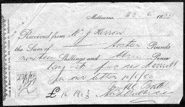
Document - Document, Receipt 1950, c1950
Mr John Herron and his wife Isa Mary Herron purchased the house at 4 Vickery Street Bentleigh in 1950 from Miss M Marriott. He was a descendant of John James an early settler dairyman in Moorabbin Shire and Miss M Marriott was a descendant of the early settler market gardeners Marriott family. Mr Herron lived there until 1989 and the house was then demolished and turned into a carpark for the busy Shopping precinct of Centre Road, Bentleigh.The Marriott family were early settler market gardeners from 1878 in the area of Dendy’s 1841 Special Survey and John Herron was a descendant of Philip Jones , a chair-maker, who settled in the area of East Brighton, now Bentleigh, in 1852 An original paper receipt, dated 25/6/1950, for solicitors fees regarding the purchase of the house a 4 Vickery Street Bentleigh by Mr John Herron from Miss M Marriott. Melbourne 23-6- 1950/ Received from Mr. J. Herron / the Sum of – Sixteen Pounds / nineteen Shillings and three Pence / being costs & fees re Marriott / per letter 10/5/50 / £16.19.3 signed N Boothby Boothby / stamp in left corner dated 23/6/50 / along left side Cook & Heathcote Pty. Ltd., 404 Collins St., Melbournepioneers, early settlers, brighton, moorabbin, bentleigh, market gardeners, dairyman, dairy farmer, jones james, jones mary ann, jones martha, jones elizabeth ann, dendy henry, dendys special survey 1841, elster creek, melbourne, jones ethel may, herron isa mary, herron john, tram conductor, marriott m, cook and heathcote pty ltd -
 City of Moorabbin Historical Society (Operating the Box Cottage Museum)
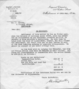
Document - Document, letter of costs 1950, c1950
Mr John Herron and his wife Isa Mary Herron purchased the house at 4 Vickery Street Bentleigh in 1950 from Miss M Marriott. He was a descendant of John James an early settler dairyman in Moorabbin Shire and Miss M Marriott was a descendant of the early settler market gardeners Marriott family. Mr Herron lived there until 1989 and the house was then demolished and turned into a carpark for the busy Shopping precinct of Centre Road, Bentleigh.The Marriott family were early settler market gardeners from 1878 in the area of Dendy’s 1841 Special Survey and John Herron was a descendant of Philip Jones , a chair-maker, who settled in the area of East Brighton, now Bentleigh, in 1852 An original letter, dated 10th May 1950, from solicitors Boothby and Boothby requesting settlement of costs involved with purchase of house at 4 Vickery Street Bentleigh by Mr John Herron from Miss M Marriott Attached is a Statement of Adjustments cat 00053.4 * Boothby & Boothby Imperial Chambers / Solicitors etc. 408 Collins Street/ B>B Boothby / N.B Boothby / - BBB/VP Melbourne C 10th May, 1950/ and at / Korumburra / Loch and / Poowong/ Telephone M 1275 ( 2 Lines )/ Mr. J. Herron, / 4 Vickery Street, / Bentleigh / re Marriott signed N Boothby solicitors, pioneers, early settlers, brighton, moorabbin, bentleigh, market gardeners, dairyman, dairy farmer, jones james, jones mary ann, jones martha, jones elizabeth ann, dendy henry, dendys special survey 1841, elster creek, melbourne, jones ethel may, herron isa mary, herron john, tram conductor, marriott m, boothby and boothby -
 City of Moorabbin Historical Society (Operating the Box Cottage Museum)
Document - Document, statement of fees 1950, c1950
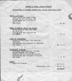
Mr John Herron and his wife Isa Mary Herron purchased the house at 4 Vickery Street Bentleigh in 1950 from Miss M Marriott. He was a descendant of John James an early settler dairyman in Moorabbin Shire and Miss M Marriott was a descendant of the early settler market gardeners Marriott family. Mr Herron lived there until 1989 and the house was then demolished and turned into a carpark for the busy Shopping precinct of Centre Road, Bentleigh.The Marriott family were early settler market gardeners from 1878 in the area of Dendy’s 1841 Special Survey and John Herron was a descendant of Philip Jones , a chair-maker, who settled in the area of East Brighton, now Bentleigh, in 1852 An original, paper, Statement of Adjustments attached to previous item 00053.3 for purchase of the house at 4 Vickery Street, Bentleigh by Mr John Herron from Miss M Marriott in 1950 Heading - HERRON & ANOR. From MARRIOTT / Adjustment of Rates, Taxes, etc., as at 12th May 1950 / list of costs/ typed in left hand bottom corner – E. & O.E, / Melbourne, / 10th May 1950 pioneers, early settlers, brighton, moorabbin, bentleigh, market gardeners, dairyman, dairy farmer, jones james, jones mary ann, jones martha, jones elizabeth ann, dendy henry, dendys special survey 1841, elster creek, melbourne, jones ethel may, herron isa mary, herron john, tram conductor, marriott m, boothby b b, boothby n b, solicitors, land sales, house sales 1950, real estate