Showing 2607 items matching "aerial"
-
 Tatura Irrigation & Wartime Camps Museum
Document, Institute for Irrigation and Salinity Research, 1987
Visitors' guide to activities on display for 50th Anniversary 1937-1987. October 23-24, 1987 days of display.Cream card cover. Blue printing, aerial vies of Institute. Map of areas affected by work of local Institute group. Pages joined by staples and not attached to coverfruit, salinity, soils, rural, industries, agriculture -
 Whitehorse Historical Society Inc.
Map, Photo-map Ringwood A4A, 1945
Aerial photo covering approximately from Box Hill to Mitcham (West to East) and Springfield Road to Hawthorn Road (North to south).Aerial photo covering approximately from Box Hill to Mitcham (West to East) and Springfield Road to Hawthorn Road (North to south). Names of main roads inscribed.Aerial photo covering approximately from Box Hill to Mitcham (West to East) and Springfield Road to Hawthorn Road (North to south).aerial photographs, box hill, blackburn, nunawading, forest hill, mitcham -
 Rutherglen Historical Society
Newspaper - Image
One of a group of photographs of Rutherglen collected from magazines (Pix or People or Post), then pasted onto orange paper, date unknown. This one is an aerial view of Rutherglenrutherglen -
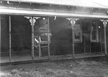
 St Patrick's Old Collegians Association (SPOCA)
Photograph - Buildings, Aerial, c.1930
-
Port Melbourne Historical & Preservation Society
Financial record, Pat Grainger, Port Melbourne Historical & Preservation Society Annual Report 2012, Aug 2012
PMH&PS was incorporated in 1994, and from 1995 was required to hold an AGM and present an Annual Report. These were compiled, designed, printed on photocopier and bound by the Secretary, except for the Tenth anniversary edition and most recent edition, commercially photocopied.Annual Report of the PMH&PS, 2012 A5 Pale grey with aerial photograph of Port Melbourne, including Lagoon. Contains financial reports, list of members and photossocieties clubs unions and other organisations, port melbourne historical & preservation society, pmhps, annual report -
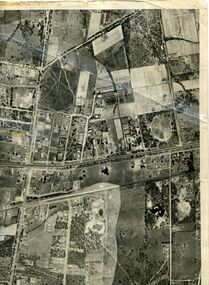
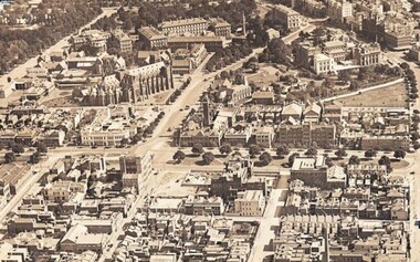
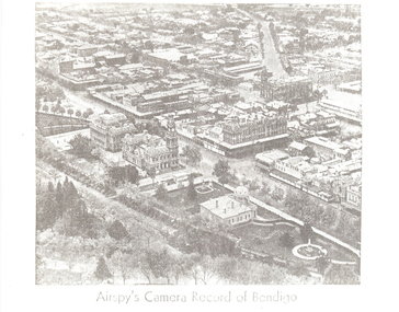 Bendigo Historical Society Inc.
Photograph - AERIAL VIEW: BENDIGO, Approx. 1935
BHS Collectionblack and white photo ( from newspaper /): aerial view of Bendigo City Centre, Post Office and Shamrock Hotel. Rosalind Park in foreground, looking north east.Airspy ?place, aerial view of bendigo -
 Tatura Irrigation & Wartime Camps Museum
Photograph, Tatura Research Station
First office of the Tatura Research Station.|Aerial photo of Research Institute 2000. -
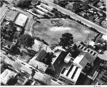 Stawell Historical Society Inc
Photograph, Stawell Technical School -- Aeriel View 1967, 5/6/1967
Five black and white photographs - Aerial view showing Stawell Technical School students on oval form initials sts -
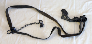 Orbost & District Historical Society
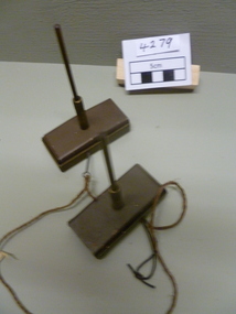
PMG telephone line strainer
This was used by PMG technicians in Orbost from 1957. These strainers were used until the end of open aerial routes which were phased out over many years at a guess right into the 1980’s. They were a standard and necessary issue device for any linesman working on open aerial routes. A leather strap with metal fittings. It consists of two flat steel surfaces operated by a lever action to grip the wire without causing damage.pmg telephone communication wire-strainer wire-tensioner telecommunications -
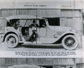 Victoria Police Museum
Photograph (police car), 04/03/1923
Wireless patrol car which is a Lancia Trikappa Tourer. The 7-stage amplifier with the tuning condenser can be seen through the open door of the car. Police dog on the running board. Photograph appeared in Popular Radio Weekly, March 4, 1923. The transmitter aerial was strung between the front and rear mudguards and lenghened by the driver raising the pole in order to improve reception. The receiver aerial is tied to the underneath of the roof.police vehicles; lancia trikappa tourer; motor police branch; wireless patrol; transport -
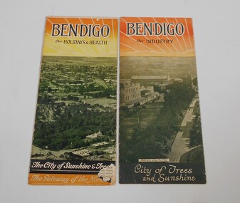 Bendigo Historical Society Inc.
Pamphlet - Two small pamphlets. One titled Bendigo for holidays and health, the other Bendigo for industry
Advertising material promoting the City of BendigoOne pamphlet as at the top Bendigo for industry, Bendigo the northern capital of Victoria, with a drawing of a rising sun. Under a black and white aerial photo of Pall Mall with the soldier's memorial in the foreground and the words: City of trees and sunshine, distributing centre to the golden north at the bottom. The other Bendigo for holidays and health, Bendigo the northern capital of Victoria. An aerial view of the City and the words The city of sunshine and trees, the gateway of the north.advertising, bendigo -
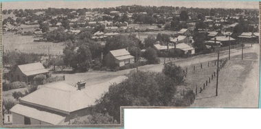
City of Kingston
Photograph - Black and white, 5 January 1984
Cheltenham and Heatherton are suburbs in the City of Kingston that were originally established as a rural market gardening community. The market gardens, farms and paddocks have gradually been sub-divided into housing and industrial estates and associated infrastructure such as schools and shopping facilities. This aerial image covers a diverse section of the City of Kingston, taking in the suburbs of Cheltenham, Heatherton, Mentone and Parkdale. By 1984, the market gardens of the district have been replaced by housing and factories. The Nylex factory is visible and now closed. Mentone Bowl on the corner of Warrigal Road and Nepean Highway has now been replaced by high rise apartments, another feature of the changing landscape in the City of Kingston. The vacant land now occupied by the Moorabbin Airport Direct factory Outlet (DFO) is also depicted.Aerial photograph of Cheltenham, Heatherton, Mentone and Parkdale within the City of Kingston. The area depicted in the 1984 aerial view includes Centre Dandenong Road and Cheltenham East Primary School (top left), Kingston Heath Reserve (top right), intersection of Lower Dandenong Road, Warrigal Road, Balcombe Road and Nepean Highway (bottom left), Balmoral Drive/McSwain Street Parkdale (bottom right).White text: 3831-179 Lens information [indecipherable] RINGWOOD M/S 7922-3 RUN 16 [Clockface image] 5,300' ASL VIC DLS© 5-1-84cheltenham, heatherton, mentone, parkdale, market gardens, urbanisation -
 Eltham District Historical Society Inc
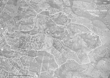
Work on paper (Sub-Item) - Photograph, Research Creek
Black and White aerial photograph of Research witht the Research Creek and Main Road highlighted.eltham, research, aerial view, research creek -
 St Kilda Historical Society
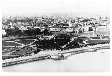
Photograph - Photograph - aerial view, 1920s
Aerial view of St Kilda from Port Phillip Bay, with Catani Gardens in the foregroundblack and white, photograph arial original catani gardens, fitzroy street -
 Bendigo Military Museum
Booklet - COLLECTION OF PHOTOS AFTER PEARL HARBOUR BOMBING, 1941
Item is part of the BCOF Association collection, refer Cat No 7625.This is a compendium of ground level and aerial photos of bomb damaged Pearl Harbour. Each photo, black and white, size about 14.5 x 18.5. They are contained in a plastic folder.Typed on top of first photo is:- "Received these photos from an old shipmate on the USS QUAPAW ATF-110. Interesting as I have never seen them anywhere else. I think they are spectacular." Pearl Harbour December 7th 1941.ww2, pearl harbour, copes of photographs -
 Phillip Island and District Historical Society Inc.
Photograph, 1969
One of 16 photographs and postcards donated by Mary KarneyBlack & White Aerial photograph of the two bridges linking San Remo with Newhaven, Phillip Island. San Remo Jetty and township bottom left foreground. Newhaven on the top.On back: "Two bridges San Remo 1969."the two bridges san remo, san remo to newhaven, phillip island bridges, mary karney -
 Phillip Island and District Historical Society Inc.
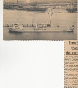
Newspaper clippings, 22/02/1967
Collection of newspaper clippers in scrap book dated 1960 - 1973Article re the tanker, "Esyra" arriving at Crib Point refinery with Persian Gulf oil. The largest tanker to arrive at that time. Aerial photo of the tanker at Crib Point Jetty.local history, newspapers, westernport oil installation, arrival of tanker "esyra", crib point, jean jamieson -
Glenelg Shire Council Cultural Collection
Photograph - Photograph - View of port and facilities, c. 1974
Port of Portland Authority archives.Front: (no inscriptions) Back: (no inscriptions)port of portland archives -
Glenelg Shire Council Cultural Collection
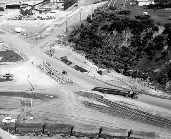
Photograph - Photograph - Aerial view from the N.W. of Portland Harbour under construction, c. 1950
Port of Portland Authority archives.Front: (no inscriptions) Back: (no inscriptions)port of portland archives -
Glenelg Shire Council Cultural Collection
Photograph - Photograph - Portland abattoir & Portland drive-in theatre, 1970s
Donated by abattoir staff during clean-up prior to demolition in 1996. Company was then owned by Australian Meat HoldingsBlack and white photograph, framed. Frame: stained wooden moulding c. 1970s. Image: Portland abattoirs, aerial view from N.E. Portland Drive-in theatre in backgroundFront: Photocopy - legend of key functions of the abattoir buildingsaerial photography, drive-in cinema, abattoir, industry, recreation -
Glenelg Shire Council Cultural Collection
Photograph - Photograph - aerial view of Portland coast, c. 1954
Black and white aerial photograph of coastline around Portland. Black border, scale all sides, 5 rows of 3 't' at regular intervals. Ocean, land with lakesFront: '820 -8' - handwritten, white, lower border 'RUN 5' 'PORTLAND', printed, white, lower borderaerial photography, central portland, portland harbour, south west coastline -
 Glenelg Shire Council Cultural Collection
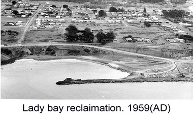
Photograph - Photograph - Lady Bay Reclamation: Aerial view looking West showing dumping of quarry overburden, 1959
Port of Portland Authority archivesFront: (no inscriptions) Back: Lady Bay Reclamation 1959 (black pen, upper left)port of portland archives, lady bay, reclamation, 1960s -
 Glenelg Shire Council Cultural Collection
Photograph - Photograph - Lady Bay Reclamation: Aerial view looking West showing dumping of quarry overburden, 1959
Port of Portland Authority archivesFront: (no inscriptions) Back: Lady Bay Reclamation 1959 (black pen, upper left)port of portland archives, lady bay, reclamation -
 Glenelg Shire Council Cultural Collection
Photograph - Photograph - Lady Bay Reclamation: Aerial view looking West showing dumping of quarry overburden, 1959
Port of Portland Authority archivesFront: (no inscriptions) Back: Lady Bay Reclamation 1959 (black pen, upper left)port of portland archives, lady bay, reclamation, 1959 -
Glenelg Shire Council Cultural Collection
Photograph - Photograph - View of Portland and foreshore, 21/03/1972
Port of Portland Authority archives.Front: (no inscriptions) Back: (no inscriptions)port of portland archives, portland harbour -
 Glenelg Shire Council Cultural Collection
Photograph - Photograph - Portland Harbour, 1960-1966
Port of Portland Authority archivesFront: (no inscriptions) Back: (no inscriptions)port of portland archives -
Port Melbourne Historical & Preservation Society
Photograph - Aerial view Maribyrnong and Yarra rivers and Coode Island, c. 1976
Donated to City of Port Melbourne by Councillor Russell GRIFFITHS.Aerial photograph taken from above junction of Yarra and Maribyrnong rivers showing oil and chemical storage farm at Coode Island and four container vessels at Swanson Dock.transport - shipping, piers and wharves - miscellaneous, swanson dock -
 National Vietnam Veterans Museum (NVVM)
Weapon, Detonator
Two metal trip fuse/etonators. Rectangular metal bow that opens and has an attachment that stands like an aerial on its lid. Line attached to a pin at its side.detonator, fuse /detonator. -
Port Melbourne Historical & Preservation Society
Postcard, South Melbourne Gasworks, c. 1928
One from a set of six postcards related to the Gasworks and produced from early images by the Cty of Port Phillip: South Melbourne Gasworks aerial photographic view, '1928'Cards have three logos: Gasworks Arts, City of Port Phillip, Gas and Fuel Corporationindustry, utilities - gas, built environment - industrial, sandridge lagoon, gasworks, south melbourne gasworks -
Port Melbourne Historical & Preservation Society
Plan - Map and aerial photo of Port Melbourne, c. 1990
Notations made as a result of conversations Anne had in the early 1990s with an elderly male resident of Port Melbourne.Map and Aerial photo of Port Melbourne with handwritten annotations detailing the location of various buildings, trotting tracks, etc which previously existed in Port Melbourne (recollections only).fishermans bend