Showing 1438 items matching "allotment"
-
 Wodonga & District Historical Society Inc
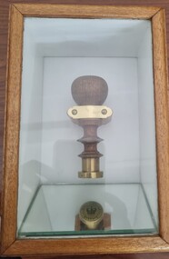
Functional object - Seal - Police Office, Belvoir
This seal was used for official police and court documents by the Belvoir Police Office.The initial land survey for the city now known as Wodonga was first undertaken in 1852 by Thomas Wedge - Assistant Surveyor. The new township was called "Belvoir" and was proclaimed by that name in 1852 and again in 1861. The first sale of land in Belvoir was held at Wangaratta on April 28, 1854, when all the allotments surveyed by Thomas Wedge (excepting those set apart for reserves, government and public areas) were offered at auction. Following representations by the Postmaster General on June 23, 1869, the Governor in Council, on July 12, 1869, approved of its Aboriginal name "Wodonga" being restored. The seal was found at the Yackandandah Courthouse by the Circuit Judge, the late Mr. Jim Humphrey. As the Wodonga Historical Society was in recess at that time, the seal was held in trust by the North-East Historical Society in Wangaratta. It was donated to the Wodonga Historical Society in 1987.This item was the official seal of the Belvoir Police office from the beginning of the European settlement of the modern day city of Wodonga, then know as Belvoir. It is one of the earliest relics of that period of history, until its name was changed in 1869.Wood and metal seal bearing the official emblem of the Police Office Belvoir. It would have been used to apply a wax seal to official documents. The seal is mounted in a timber and glass case so that the imprint of the seal can be seen reflected in a mirror mounted in the base of the box.Around the edges of the seal "POLICE OFFICE / BELVOIR"belvoir police, official seal, history wodonga -
 Ringwood and District Historical Society
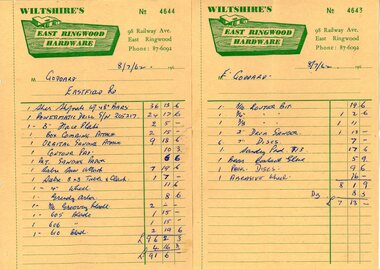
Document - Manila Folder, Collection of personal documents for Mr Emil Goddard, 15 Eastfield Road, Ringwood East, Victoria, 1947-1953
Correspondence between Mr Goddard and Repatriation Department regarding War Pension entitlements. Specifications of work to be done and materials to be used in the erection of a timber residence at 15 Eastfield Road, Ringwood East, for E.K. Goddard. Contract of Sale of Land at Lots 55 & 56 on P/S No.10492, part of Crown allotments 27 and 28,B, Parish of Ringwood, County of Mornington. Miscellaneous receipts from 1947-1953 including Hire Purchase Agreement for Hillman Minx car. Also includes letter from Presbyterian Ladies' College referring to 1953 term 1 fee of £18.0.3 for Margaret Goddard Receipts from Wiltshire's East Ringwood Hardware, 98 Railway Avenue, East Ringwood, Phone 87-6092, 8/7/1962. -
 Bendigo Historical Society Inc.
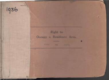
Book - RIGHT TO OCCUPY RESIDENCE AREA COLLECTION: REGISTER 1936
COLLECTION OF RIGHT TO OCCUPY A RESIDENCE AREA -LAND (RESIDENCE AREAS ) Act 1935 / thick cardboard book -cloth and string binding / written on front in texter '1936' / numbers 5001 to 5100 / inside - stubs of documents showing Granted to , of, period, Date of Right , Description of Land , Allotment, Section, City, Town , Borough , Township of , Parish of , Authorised Person . Rubber stamps show The interest of this Right has been transferred to /one stub shows Department of Lands and Survey note on Bendigo Historical Society Catalogue Sheet dated 12.6.2008 All buts completed and original application forms removed. Note -forms were originally in triplicate on one page with serrations for removal of two parts; butts remain .Residence areas in Central Goldfields.Bendigo City Council - Acquisition 1990organization, government, official -
 Bendigo Historical Society Inc.
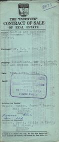
Document - H.A. & S.R. WILKINSON COLLECTION: CONTRACT OF SALE
Contract of sale of real estate dated 12th April, 1961 between Bendigo and Eaglehawk Star Permanent Building Society (vendor) and Mr.E.A. & Mrs. L.M. Spence (purchaser). Solicitor for vendor: Messrs. Watson, James & Rogers, Bull Street, Bendigo. Solicitor for purchaser: Messrs. Hyett, Willis & Hyett, Bull Street, Bendigo. Property: vacant land corner Holdsworth Road and Britton Street, Bendigo being lot 3 on plan of subdivision No. 52449, having a frontage of 56 feet 7 inches with a width at the rear of 58 feet 5 inches with a depth of 97 feet 5.5 inches being part of crown allotment 31 section F at Bendigo described in Crown volume 8242 folio 057. Price 410 pounds.organization, business, h.a. & s.r wilkinson real estate -
 Bendigo Historical Society Inc.
Document - H.A. & S.R. WILKINSON COLLECTION: CONTRACT OF SALE
Contract of sale of real estate dated 22nd December, 1960 between Mr. W. B. Nicholls (vendor) and Mr. C. W. & Mrs. F. L. Silk (purchaser). Solicitor for vendor: Messrs Hyett, Willis & Hyett, Bull Street, Bendigo. Solicitor for purchaser: Messrs. Tatchell, Dunlop, Smalloy & Balmer, Williamson Street, Bendigo. Property: vacant land corner Derna Court and Poplar Street, Golden Square, being lots 20,21,22,23,24, 25, 26 and 27 fronting Derna Courton plan of subdivision no. B80611 and lot 1 on plan of subdivision no. 51583 lodged in the office of titles and being part of Crown allotment 11 section 24A at Bendigo described in Crown grant volume 8217 folio 121. Price 4,900 pounds .organization, business, h.a. & s.r wilkinson real estate -
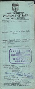
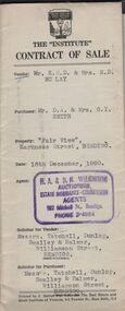 Bendigo Historical Society Inc.
Document - H. A. & S. R. WILKINSON COLLECTION: CONTRACT OF SALE
Contract of sale dated 16th December, 1960 between Mr. K. E. D. & Mrs. E. D. Mc Lay (vendor) and Mr. D. A. & Mrs. G. I. Smith (purchaser). Solicitor for vendor: Messrs. Tatchell, Dunlop, Smalley & Balmer, Williamson Street, Bendigo. Solicitor for purchaser: Messrs. Tatchell, Dunlop, Smalley & Balmer. Solicitor for purchaser: Messrs. Tatchell, Dunlop, Smalley & Balmer, Williamson Street, Bendigo. Property: "Fair View" Harkness Street, Bendigo being part of Crown allotment 15 section 108C being the balance of land now comprised in certificate of title volume 7383 folio 509 together with all floor coverings, blinds, curtains and electric light fittings and shades as inspected. Price 2,600 pounds.organization, business, h.a. & s.r wilkinson real estate -
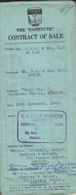 Bendigo Historical Society Inc.
Document - H.A & S. R. WILKINSON COLLECTION: CONTRACT OF SALE
Contract of sale dated 16th December, 1960 between Mr. K. E. D. & Mrs. E. D. Mc Lay (vendor) and Mr. D. A. & Mrs. G. I. Smith (purchaser). Solicitor for vendor: Messrs. Tatchell, Dunlop, Smalley & Balmer, Williamson Street, Bendigo. Solicitor for purchaser: Messrs. Tatchell, Dunlop, Smalley & Balmer. Solicitor for purchaser: Messrs. Tatchell, Dunlop, Smalley & Balmer, Williamson Street, Bendigo. Property: "Fair View" Harkness Street, Bendigo being part of Crown allotment 15 section 108C being the balance of land now comprised in certificate of title volume 7383 folio 509 together with all floor coverings, blinds, curtains and electric light fittings and shades as inspected. Price 2,600 pounds.organization, business, h.a. & s.r wilkinson real estate -
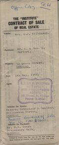 Bendigo Historical Society Inc.
Document - H.A & S. R. WILKINSON COLLECTION: CONTRACT OF SALE
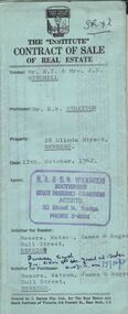
Contract of sale of real estate dated 5th May, 1966 between Mrs. G. J. Wilkinson (vendor) and Mr. C. & Mrs. L. Sartori (purchaser). Solicitor for vendor: Messrs. Schleiger & Smalley, Williamson Street, Bendigo. Solicitor for purchaser: Mr. H. E. Every, Dispensary Walk, Bendigo. Property 52 Queen Street, Bendigo being Crown allotment 16 section 29C land described in certificate of title volume 2585 folio 307 together with all floor coverings, blinds, curtains & electric light fittings and shades. Price 11,800 dollars. Attached plans of inside, Insurance cover note, engagement or appointment in writing pursuant to section 33 of the estate agents act and statement pursuant to section 34 of the estate agents act.organization, business, h.a. & s.r wilkinson real estate -
 Bendigo Historical Society Inc.
Document - H. A. & S. R. WILKINSON COLLECTION: CONTRACT OF SALE
Contract of sale of land dated 28th April, 1956 between Mr. L. F. Bright (vendor) and Mrs. E. Tyack (purchaser). Property: land having a frontage of 125 links to McKenzie street West by a depth of 392 links to Mistletoe Street being Crown allotment 10 section 578 Parish of Sandhurst City of Bendigo being land described in certificate of title volume 5975 folio 905 and situate corner McKenzie Street West and Mistletoe Street, Golden Square, together with weatherboard dwelling and all sundry outbuilding, also all inside and outside blinds, lino in backroom, all curtains, except those in the front bedroom and all electric light fittings and shades escept shade in lounge room. Price 1,100 pounds.organization, business, h.a. & s.r wilkinson real estate -
 Kew Historical Society Inc
Plan - Subdivision Plan, Corsewall Estate, Hawthorn, 1938
The Kew Historical Society collection includes almost 100 subdivision plans pertaining to suburbs of the City of Melbourne. Most of these are of Kew, Kew East or Studley Park, although a smaller number are plans of Camberwell, Deepdene, Balwyn and Hawthorn. It is believed that the majority of the plans were gifted to the Society by persons connected with the real estate firm - J. R. Mathers and McMillan, 136 Cotham Road, Kew. The Plans in the collection are rarely in pristine form, being working plans on which the agent would write notes and record lots sold and the prices of these. The subdivision plans are historically significant examples of the growth of urban Melbourne from the beginning of the 20th Century up until the 1980s. A number of the plans are double-sided and often include a photograph on the reverse. A number of the latter are by noted photographers such as J.E. Barnes.This is a second, more complete version of the Corsewall Estate subdivision that is held by the Society. The Coreswall Estate was a subdivision, bordering on Barkers Road and Auburn Road, which created Corsewall Close. This relatively late subdivision included 29 allotments. The subdivision plan includes the dimensions of each lot as well as the width of the existing and projected roads and turning circles. The Corsewall Close Precinct is now listed on the Victorian Heritage Database (HO147) and is noted for its ‘consistent flat-type development over the entire street, which has been cleverly designed to make multi-unit dwellings appear as single buildings’. In this second version of the plan, the rarity of this late subdivision is emphasised by the auctioneers. The original plan must have contained a photograph, which is unfortunately truncated here.subdivision plans - hawthorn, corsewall estate -
 Kew Historical Society Inc
Plan - Subdivision Plan, Erin Heights Estate, East kew, 1917
Pru Sanderson, in her groundbreaking ‘City of Kew Urban Conservation Study : Volume 2 - Development History’ (1988), summarised the periods of urban development and subdivisions of land in Kew. The periods that she identified included 1845-1880, 1880-1893, 1893-1921, 1921-1933, 1933-1943, and Post-War Development. These periods were selected as they represented periods of rapid growth or decline in urban development. An obvious starting point for Sanderson’s groupings involved population growth and the associated economic cycles. These cycles also highlighted urban expansion onto land that was predominantly rural, although in other cases it represented the decline and breakup of large estates. A number of the plans in the Kew Historical Society’s collection can also be found in other collections, such as those of the State Library of Victoria and the Boroondara Library Service. A number are however unique to the collection.The Kew Historical Society collection includes almost 100 subdivision plans pertaining to suburbs of the City of Melbourne. Most of these are of Kew, Kew East or Studley Park, although a smaller number are plans of Camberwell, Deepdene, Balwyn and Hawthorn. It is believed that the majority of the plans were gifted to the Society by persons connected with the real estate firm - J. R. Mathers and McMillan, 136 Cotham Road, Kew. The Plans in the collection are rarely in pristine form, being working plans on which the agent would write notes and record lots sold and the prices of these. The subdivision plans are historically significant examples of the growth of urban Melbourne from the beginning of the 20th Century up until the 1980s. A number of the plans are double-sided and often include a photograph on the reverse. A number of the latter are by noted photographers such as J.E. Barnes.The Erin Heights Estate in Kew included just seven lots in in Valerie Street. These were all that remained of this wartime subdivision, the other 11 allotments on Balfour and Belford Roads having already been sold. Balfour Road was to be only a temporary name as the street is currently called Windella Avenue. Now, the parkland opposite the subdivision is the reserve created from the route of the Outer Circle Railway. This Railway reached Kew East in 1925, but had been planned as far back as 1873. The development focuses on the benefits of living in Kew: being at the highest of Kew’s ‘suburbs’; being a good residential area; its rapid growth; and the proximity of the Kew East tram in High Street. In 1917, the electric tramline only extended to a terminus at the Harp of Erin hotel. The terminus is clearly represented on the plan.subdivision plans - east kew, erin heights estate -
 Bendigo Historical Society Inc.
Document - H.A. & S.R. WILKINSON COLLECTION: CONTRACT OF SALE
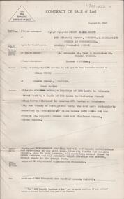
This business was owned by father and son, Henry Archibald Wilkinson and Samuel Ronald "Ron" Wilkinson. Henry (1882-1954) was born in Shepparton and died in Bendigo. He was married to Grace Hovendon in 1908. Samuel Ronald "Ron" (1914-1995), Henry's son, was married to Florence Jean McKerlie in 1937.Contract of sale of real estate between Mr. R.T. & Mrs J.V. Mitchell (Vendor) and Mr. R.W. Stretton (purchaser) for property at 28 Olinda Street, Bendigo dated 12th October, 1962. Solicitor for vendor: Messrs Watson, James & Rogers - Bull Street Bendigo. Solicitor for purchaser: Messrs. Watson, James & Rogers of Bull Street, Bendigo. Sale of piece of land part of Crown allotment 6, section 68c land described in Certificate of title volume 4472, folio 399, together with a right of carriageway over the road coloured brown on the map drawn on the said certificate of title, together with all floor coverings, blinds, curtains, electric light fittings and shades, gas fire and gas copper. Price 1,850 pounds.organization, business, h.a. & s.r wilkinson real estate -
 Bendigo Historical Society Inc.
Document - H.A. & S.R. WILKINSON COLLECTION: CONTRACT OF SALE
This business was owned by father and son, Henry Archibald Wilkinson and Samuel Ronald "Ron" Wilkinson. Henry (1882-1954) was born in Shepparton and died in Bendigo. He was married to Grace Hovendon in 1908. Samuel Ronald "Ron" (1914-1995), Henry's son, was married to Florence Jean McKerlie in 1937.Contract of sale of land dated 28th November, 1958 between Mrs. V. Hunt (seller) and Mrs. L.M. Salis (buyer). Solicitor for vendor: Messrs. Hyett, Willis & Hyett, Bull Street, Bendigo. Solicitor for purchaser: Messrs. Watson, James & Rogers, Bull Street, Bendigo. For so much and such parts as lie above the depth of fifty feet below the surface of land being lot 1 on the vendor plan of subdivision situate at the corner of Victoria and Prout Streets, Bendigo part of allotment 420A section K land being delineated and colored red, blue and brown on the map in the margin hereof, together with all buildings thereon and with all floor coverings, internal and external blinds, curtains and electric light fittings and shades. Price 2,000 pounds.organization, business, h.a. & s.r wilkinson real estate -
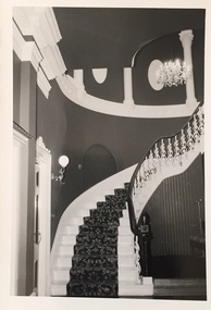
 Kew Historical Society Inc
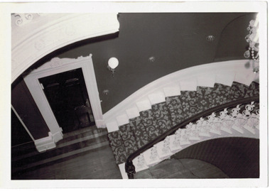
Photograph - 'Butleigh Wooton', 867 Glenferrie Road, John T Collins, 1979
in 1882 Thomas Maidment paid the Society of Jesus £5,750 for nine allotments along Barkly Road (now Glenferrie Road). Maidment, who had arrived in Australia from the Glastonbury district in England in 1858, owned and managed a number of sheep stations in Victoria and subsequently became an '... eminently respectable ...' member of District society. In 1883 the Rate Books list Maidment's land in Barkly Road as the 'Buxton Hill Estate' and it was given an N.A.V. of £90, while in the following year his property attracted an N.A.V. of £160, suggesting that substantial improvements were taking place. Maidment's two-storey mansion, named 'Butleigh Wooton' after his birth-place in England, was completed in 1885 and was given an initial N.A.V. of £420. While Maidrnent is recorded as the owner of the building until at least 1896, Jane Maidment, his wife, continued the family ownership of the twenty-six roomed house with its extensive grounds until at least 1910. (Sanderson P. City of Kew Urban Conservation Study Vol 2)Butleigh Wooton is a substantial two storeyed house built in the Italianate style common in the 1880s. Its walls are rendered and it has limited applied decoration that includes brackets to the eaves line and engaged ionic columns under a broken pediment over the front entrance. The bowed window unit is of particular distinction and is not at all typical of this type of building. This interior by John T Collins is a view of the staircase from the first floor landing. (Sanderson P. City of Kew Urban Conservation Study Vol 2)Reverse: "JOHN COLLINS / 11 Anderson Road / Hawthorn East, 3123 / Film 395 Exposure 27A / Kew / Butleigh Wooton / Looking down on stairs / 8-4-79thomas maidment, butleigh wooton, 867 glenferrie road -- kew (vic.) -
 Kew Historical Society Inc
Photograph - 'Butleigh Wooton', 867 Glenferrie Road, John T Collins, 1979
in 1882 Thomas Maidment paid the Society of Jesus £5,750 for nine allotments along Barkly Road (now Glenferrie Road). Maidment, who had arrived in Australia from the Glastonbury district in England in 1858, owned and managed a number of sheep stations in Victoria and subsequently became an '... eminently respectable ...' member of District society. In 1883 the Rate Books list Maidment's land in Barkly Road as the 'Buxton Hill Estate' and it was given an N.A.V. of £90, while in the following year his property attracted an N.A.V. of £160, suggesting that substantial improvements were taking place. Maidment's two-storey mansion, named 'Butleigh Wooton' after his birth-place in England, was completed in 1885 and was given an initial N.A.V. of £420. While Maidrnent is recorded as the owner of the building until at least 1896, Jane Maidment, his wife, continued the family ownership of the twenty-six roomed house with its extensive grounds until at least 1910. (Sanderson P. City of Kew Urban Conservation Study Vol 2)Butleigh Wooton is a substantial two storeyed house built in the Italianate style common in the 1880s. Its walls are rendered and it has limited applied decoration that includes brackets to the eaves line and engaged ionic columns under a broken pediment over the front entrance. The bowed window unit is of particular distinction and is not at all typical of this type of building. This interior by John T Collins is a view of the staircase from the first floor landing. (Sanderson P. City of Kew Urban Conservation Study Vol 2)Reverse: "JOHN COLLINS / 11 Anderson Road / Hawthorn East, 3123 / Film 395 Exposure 21A / Kew / Butleigh Wooton / Staircase / 8-4-79thomas maidment, butleigh wooton, 867 glenferrie road -- kew (vic.), john t collins -
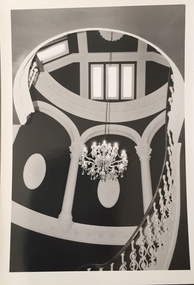 Kew Historical Society Inc
Photograph - 'Butleigh Wooton', 867 Glenferrie Road, John T Collins, 1979
in 1882 Thomas Maidment paid the Society of Jesus £5,750 for nine allotments along Barkly Road (now Glenferrie Road). Maidment, who had arrived in Australia from the Glastonbury district in England in 1858, owned and managed a number of sheep stations in Victoria and subsequently became an '... eminently respectable ...' member of District society. In 1883 the Rate Books list Maidment's land in Barkly Road as the 'Buxton Hill Estate' and it was given an N.A.V. of £90, while in the following year his property attracted an N.A.V. of £160, suggesting that substantial improvements were taking place. Maidment's two-storey mansion, named 'Butleigh Wooton' after his birth-place in England, was completed in 1885 and was given an initial N.A.V. of £420. While Maidrnent is recorded as the owner of the building until at least 1896, Jane Maidment, his wife, continued the family ownership of the twenty-six roomed house with its extensive grounds until at least 1910. (Sanderson P. City of Kew Urban Conservation Study Vol 2)Butleigh Wooton is a substantial two storeyed house built in the Italianate style common in the 1880s. Its walls are rendered and it has limited applied decoration that includes brackets to the eaves line and engaged ionic columns under a broken pediment over the front entrance. The bowed window unit is of particular distinction and is not at all typical of this type of building. This interior by John T Collins is a view of the staircase from the first floor landing. (Sanderson P. City of Kew Urban Conservation Study Vol 2)Reverse: "JOHN COLLINS / 11 Anderson Road / Hawthorn East, 3123 / Film 395 Exposure 21A / Kew / Butleigh Wooton / Staircase looking up to dome / 8-4-79thomas maidment, butleigh wooton, 867 glenferrie road -- kew (vic.), john t collins -
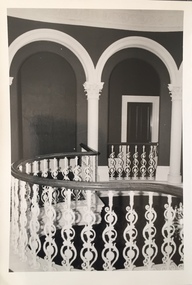 Kew Historical Society Inc
Photograph - 'Butleigh Wooton', 867 Glenferrie Road, John T Collins, 1979
in 1882 Thomas Maidment paid the Society of Jesus £5,750 for nine allotments along Barkly Road (now Glenferrie Road). Maidment, who had arrived in Australia from the Glastonbury district in England in 1858, owned and managed a number of sheep stations in Victoria and subsequently became an '... eminently respectable ...' member of District society. In 1883 the Rate Books list Maidment's land in Barkly Road as the 'Buxton Hill Estate' and it was given an N.A.V. of £90, while in the following year his property attracted an N.A.V. of £160, suggesting that substantial improvements were taking place. Maidment's two-storey mansion, named 'Butleigh Wooton' after his birth-place in England, was completed in 1885 and was given an initial N.A.V. of £420. While Maidrnent is recorded as the owner of the building until at least 1896, Jane Maidment, his wife, continued the family ownership of the twenty-six roomed house with its extensive grounds until at least 1910. (Sanderson P. City of Kew Urban Conservation Study Vol 2)Butleigh Wooton is a substantial two storeyed house built in the Italianate style common in the 1880s. Its walls are rendered and it has limited applied decoration that includes brackets to the eaves line and engaged ionic columns under a broken pediment over the front entrance. The bowed window unit is of particular distinction and is not at all typical of this type of building. This interior by John T Collins is a view of the staircase from the first floor landing. (Sanderson P. City of Kew Urban Conservation Study Vol 2)Reverse: "JOHN COLLINS / 11 Anderson Road / Hawthorn East, 3123 / Film 395 Exposure 21A / Kew / Butleigh Wooton / Railing at head of stairs / 8-4-79thomas maidment, butleigh wooton, 867 glenferrie road -- kew (vic.), john t collins -
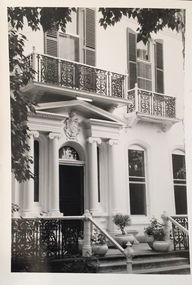 Kew Historical Society Inc
Photograph - 'Butleigh Wooton', 867 Glenferrie Road, John T Collins, 1979
in 1882 Thomas Maidment paid the Society of Jesus £5,750 for nine allotments along Barkly Road (now Glenferrie Road). Maidment, who had arrived in Australia from the Glastonbury district in England in 1858, owned and managed a number of sheep stations in Victoria and subsequently became an '... eminently respectable ...' member of District society. In 1883 the Rate Books list Maidment's land in Barkly Road as the 'Buxton Hill Estate' and it was given an N.A.V. of £90, while in the following year his property attracted an N.A.V. of £160, suggesting that substantial improvements were taking place. Maidment's two-storey mansion, named 'Butleigh Wooton' after his birth-place in England, was completed in 1885 and was given an initial N.A.V. of £420. While Maidrnent is recorded as the owner of the building until at least 1896, Jane Maidment, his wife, continued the family ownership of the twenty-six roomed house with its extensive grounds until at least 1910. (Sanderson P. City of Kew Urban Conservation Study Vol 2)Butleigh Wooton is a substantial two storeyed house built in the Italianate style common in the 1880s. Its walls are rendered and it has limited applied decoration that includes brackets to the eaves line and engaged ionic columns under a broken pediment over the front entrance. The bowed window unit is of particular distinction and is not at all typical of this type of building. This interior by John T Collins is a view of the staircase from the first floor landing. (Sanderson P. City of Kew Urban Conservation Study Vol 2)Reverse: "JOHN COLLINS / 11 Anderson Road / Hawthorn East, 3123 / Film 395 Exposure 21A / Kew / Butleigh Wooton / Entrance / 8-4-79thomas maidment, butleigh wooton, 867 glenferrie road -- kew (vic.), john t collins -
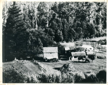 Mt Dandenong & District Historical Society Inc.
Photograph, Isaac Jeeves First Home On Running Creek 1917, 1917
Enlargement of photograph taken by Norman Rowse in 1917 that shows the first home of Isaac Jeeves built at the Running (Olinda) Creek. This photograph has a detailed inscription on the back handwritten by John Lundy-Clarke in 1974.Enlargement of photo taken by Norman Rowse in 1917 of the group of buildings erected as his first home by Isaac Jeeves at the 800° contour on the Running (Olinda) Creek on Crown Allotment 925A. The small building on the right behind the pony and the fowls was Isaac’s first substantial home and was occupied in 1858 he having lived in camp on the creek as a miner since 1855. The tall building on left was barn built in the sixties and the large roof behind was the five roomed house with a tree fern floor. This last building was of blackwood entirely above the floor and was built in the early sixties. The two old homes were pulled down by the Rowses in 1918 and the tree fern floor was pulled up by Len Childs in 1933.norman rowse, isaac jeeves, len childs, running creek -
 Federation University Historical Collection
Document - Document - Syllabus, Education Department, Victoria, Syllabus No. J1 (Girls), Junior Technical Schools
This syllabus for Girls provides the suggested time-allotment for subjects in Year 1, Year 2 and Year 3. The total hours for each year is 40 hours. Years 1 & 2 have classes in English - 5 hours; Social Studies which covers History and Civics and Geography - 4 hours; Art which covers Model Drawing, Plant Forms, Lettering and Geometrical Drawing - 6 hours; Needlecrafts which covers Plain and Decorative Needlework, Dressmaking, Millinery - 6 hours; Homecrafts which covers Cookery, Laundry, Housewifery - 4 hours; Horticulture or Special approved subjects - 2 hours; Sports, Physical Drill and Singing - 4 hours. Year 3 have English - 5 hours; Civics - 2 hours; Arithmetic and Elementary Bookkeeping - 4 hours; Science - 4 hours; Special approved subjects - 1 hour; Sports, Physical Drill and Singing - 4 hours giving a total of 20 hours. The remaining 20 hours will be for one of the following groups - (a) Dressmaking, (b) Millinery, (c) Art and Craft, (d) Cookery, (e) Homecrafts.21cm x 27.2cm sheet folded to 21cm x 13.7 education department, victoria, syllabus, girls, junior technical schools, time-allotment, hours per subject, english, social studies, history and civics, geography, hygiene and elementary physiology, arithmetic, science, art, model drawing, plant form, lettering, geometrical drawing, needlecrafts, plain and decorative needlework, dressmaking, millinery, homecrafts, cookery, laundry, housewifery, horticulture, sports, physical drill, singing, art and applied design, drafting, history and appreciation of art -
 Eltham District Historical Society Inc
Photograph, Liz Pidgeon, Heritage Excursion; East of Eltham, 6 Sep 2014, 20 May 2017
Newsletter No. 218, September 2014 September Excursion - East of Eltham Walk In Newsletter No. 197, March 2011, there was a brief history of Crown Allotment 15 Section 5 Parish of Nillumbik (CA 15) a parcel of land of a quarter of a square mile extending from Eucalyptus Road to Reynolds Road at the eastern extremity of Eltham. From the 1940s it was known as Stokes orchard. In later years it has been subdivided for residential purposes but leaving significant areas as power line and water supply reserves and bushland reserves that are habitat for the threatened For our excursion on 6th September we intend to walk through CA 15 to a bushland reserve east of Reynolds Road. The walk will traverse the boundary between suburban Eltham and the non-urban areas to the south and east. This is a pleasant walk through residential areas and bushland. Along the way we will discuss the early and more recent history of CA 15 as well as local natural history and geology. This walk is about 3.5 km in length and will take 2 to 2.5 hours. It will start at 2pm at the corner of Eucalyptus Road, Pitt Street and Nyora Road.Born Digitaleltham east, eltham district historical society, heritage excursion, activities, nyora road, reynolds road, gum tree road reserve, diosma road, stokes orchard, eucalyptus road -
 Eltham District Historical Society Inc
Photograph, Liz Pidgeon, Heritage Excursion; East of Eltham, 6 Sep 2014, 20 May 2017
Newsletter No. 218, September 2014 September Excursion - East of Eltham Walk In Newsletter No. 197, March 2011, there was a brief history of Crown Allotment 15 Section 5 Parish of Nillumbik (CA 15) a parcel of land of a quarter of a square mile extending from Eucalyptus Road to Reynolds Road at the eastern extremity of Eltham. From the 1940s it was known as Stokes orchard. In later years it has been subdivided for residential purposes but leaving significant areas as power line and water supply reserves and bushland reserves that are habitat for the threatened For our excursion on 6th September we intend to walk through CA 15 to a bushland reserve east of Reynolds Road. The walk will traverse the boundary between suburban Eltham and the non-urban areas to the south and east. This is a pleasant walk through residential areas and bushland. Along the way we will discuss the early and more recent history of CA 15 as well as local natural history and geology. This walk is about 3.5 km in length and will take 2 to 2.5 hours. It will start at 2pm at the corner of Eucalyptus Road, Pitt Street and Nyora Road.Born Digitaleltham east, eltham district historical society, heritage excursion, activities, nyora road, reynolds road, gum tree road reserve, diosma road, stokes orchard, eucalyptus road