Showing 1203 items matching "bourke street"
-
 Melbourne Tram Museum
Photograph - Set of 3 Black & White Photograph/s, Public Transport Corporation (PTC), early 1950's
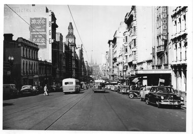
Set of three black and white prints of Bourke St, early 1950's with extensive traffic photographed in the afternoon. Photos have the cable tram track, GEC Australia (General Electric), BGE, Coles and Garrard, Myer, Post Office, Berger Paint, London Stores, Foys .1 - Looking east from about Queen St at 4pm, with two Mk 3 buses. - PTC H188 .2 - ditto with a double deck bus east bound at 215pm, PTC H189 .3 - ditto at 3pm, nearer to Elizabeth St with multiple double deck buses in the block between Elizabeth and Swanston St and extensive motor vehicle traffic. This print has been photographed from an image - has a screen. Photos maybe MMTB origin to show traffic levels in the streets. Photographed prior to the removal of double deck buses in Bourke St by January 1954. All have PTC Copyright Stamp on rear.trams, tramways, bourke st, elizabeth st, buses, double deck buses, post office, traffic control -
 Melbourne Tram Museum
Negative, Wal Jack, 13/10/1940 12:00:00 AM
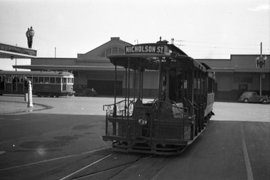
Black and white negative, by Wal Jack, of a cable tram set at the Bourke St terminus. In the background is the Spencer St station buildings and W2 269? northbound in Spencer St. The cable tram has the destination of Nicholson St. See Reg item 5056 for a similar image. Note the street light stand built into the verandah of the hotel and possibly that of Spencer St station verandah.trams, tramways, cable trams, bourke st, spencer st, w2 class, tram 269 -
 Melbourne Tram Museum
Negative, Wal Jack, 19/01/1941 12:00:00 AM
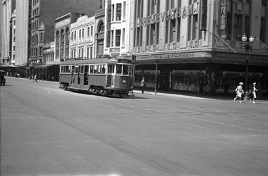
Black and white negative by Wal Jack of W3 658 (City, Route 8) in Swanston St at the corner with Bourke St, Sunday 19-1-1941. Has The Leviathan store, Ezy Walkin, Cafe Majestic. The Leviathan is holding a "Square Deal Sale". Note the two ladies crossing the street wearing gloves. Appears that a solider is standing under the verandah, with a slouch hat.trams, tramways, w3 class, swanston st, bourke st, route 8, tram 658 -
 Melbourne Tram Museum
Postcard - Set of 6 mounted cable tram postcards, 1910s
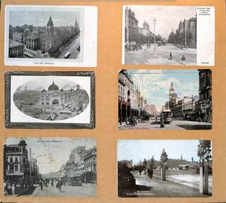
Postcards, all featuring the cable tram era, left to right, top to bottom: 1 - Town Hall Melbourne - damaged paper 2 - General view of Collins Street Melbourne - from Spring St looking west 3 - Central Railway Station, Melbourne - the principal building is complete though the roof along Swanston St over the other platforms is yet to be completed. 4 - Bourke St Melbourne - looking west from Swanston St - has the Wertheim and Roberts Stores in the view along with the post office. 5 - Bourke St Melbourne - looking east from Swanston St with Morells Orient Hotel and the Royal Mail Hotel on the two corners 6 - Melbourne from St Kilda Road.Demonstrates a set of 6 postcards featuring Melbourne cable trams.Set of 6 cable tram postcards mounted on to light weight boardtramways, flinders st station, swanston st, bourke st, collins st, st kilda road -
 Melbourne Tram Museum
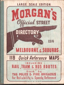
Book, The Met, "Morgan's Official Street Directory - Melbourne and Suburbs", c1951
Book - 5 sections, sewn with green cloth spine binding, card covers, 188 pages, 118 maps, titled "Morgans Official Street Directory - Melbourne and Suburbs" Has many advertisements around edges of the maps. Shows the Latrobe St line (opened 1/1951), but not the Bourke St tram line. Price 12/6. Published by Val Morgan and Sons of 64 Elizabeth St Melbourne. A web search for similar directories - Museum of Victoria - https://collections.museumsvictoria.com.au/items/1217271 gives background to the directory.trams, tramways, maps, melbourne, street directory -
 Melbourne Tram Museum
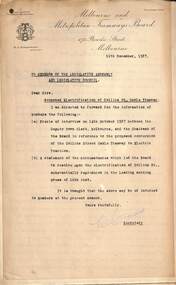
Letter, Melbourne & Metropolitan Tramways Board (MMTB), "Proposed Electrification of Collins St - cable Tramway", 12/1927
Provides information in the form of a letter to Parliamentary members about the reasons why the electrification of Collins St should proceed from the MMTB viewpoint, though it was not part of the 1923 General Scheme. The City of Melbourne initially wanted a conduit system, main issue was overhead wires, looks at other possibilities. Has a statement to the Press regarding the Board's decision to convert Collins St - options, Bourke St, Flinders St, traffic issues, and passenger / business development along Collins St. There was a lot of opposition to the proposal from the Doctors in the street.Yields information about the replacement of the Collins St cable tramways with electric trams and the reasons why.Set of six duplicated foolscap sheets secured by a foldable brass clip in top left hand corner.trams, tramways, parliament, mr strangward, collins st, cable trams, tram replacement, electrification -
 Melbourne Tram Museum
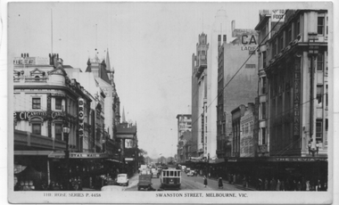
Postcard, Rose Stereograph Co, "Swanston St Melbourne Vic", early 1930s
Postcard of Swanston St Melbourne, looking south from Bourke St, Rose Series No. P4458. Has a W2 possibly No. 562 south bound showing route 2A ( ST KILDA BEACH VIA SOUTH MELBOURNE - CITY (via Swanston Street)) which dates from 1930. The Shrine of Remembrance is not visible. There are other trams in the view as well. In the background are the Royal Mail Hotel, Browns stores, Carlton Cigarettes, Robur Tea, Ezywalkin shoes and the Leviathan storeYields information about the view along Swanston St from Bourke St.Postcard - black and white, divided back, unused."$3" in pencil on the rear.trams, tramways, w2 class, swanston st, tram 562, route 2a -
 Melbourne Tram Museum
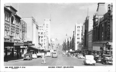
Postcard, Rose Stereograph Co, "Bourke St, Melbourne", late 1940s
Rose Series postcard No. P 2745, titled "Bourke St, Melbourne". Photo taken from between Exhibition and Russell Streets looking west, with two double deck buses and one single deck bus in the view. The cable tram track remains in position. Photo late 1940s.Yields information about the eastern end of Bourke St in the late 1940s.Postcard - printed real photograph with Rose Stereograph Co. name on the rear.tramways, trams, bourke st, buses, mmtb buses -
 Melbourne Tram Museum
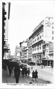
Postcard, Rose Stereograph Co, "Elizabeth Street Melbourne", c1930
Rose Series postcard No. P 1704 titled "Elizabeth Street Melbourne", looking south from the Post Office steps, just north of Bourke St. Has three cable trams in the view, along with the State Savings Bank Building, Flinders Street Railway Station building, adverts for Tintex Dye, Carlton draught beer and R W Rab.Yields information about Elizabeth St, c1930Postcard - printed real photograph with Rose Stereograph Co. name on the rear.On rear in pencil "KM-M-079" and a Ken Magor stamp.trams, tramways, flinders st station, cable trams, elizabeth st -
 Melbourne Tram Museum
Negative, Wal Jack, 25/06/1955 12:00:00 AM
Black and white negative, by Wal Jack, of W7 1011 (East Preston, route 88) in Bourke St crossing Russell St, 25-6-1955 In the background is A C Pearl Handbag and Travel goods specialist, Richardson Wine and Spirit store which appears to be closed, Normans, E Watkins? and Bank of NSW. Note the soft top Morris and the men on the street corner squatting.trams, tramways, bourke st, route 88, russell st, w7 class, east preston, tram 1011 -
 Northern District School of Nursing. Managed by Bendigo Historical Society Inc.
Document - Correspondence emails from Fay Bourke
The Northern District School of Nursing opened in 1950 in to address the issues around nurse recruitment, training and education that had previously been hospital based. The residential school was to provide theoretical and in-house education and practical training over three years. The students would also receive practical hands-on training in the wards of associated hospitals. The Northern District School of Nursing operated from Lister House, Rowan Street, Bendigo. It was the first independent school of nursing in Victoria and continued until it closed in 1989. The book "The First of its Kind" was published in 2015. Printed in Bendigo, by Bendigo Modern Press. Three pages of emailed correspondence from Fay Bourke.Three A4 pages of personal stories and one page of correspondence from Erica Lightbody. All for information from Fay Bourke for the NDSNGA Inc. publication - "The First of its Kind".all documents were regarding the compilation of the ndsnga inc. book "the first of its kind"., four a4 pages of personal anecdotes, one page of correspondence and a photocopy of a photo -
 Melbourne Tram Museum
Map, Melbourne & Metropolitan Tramways Board (MMTB), MMTB Route Maps, 1979
Series of colour maps for various tram and bus routes, dated 1979. Also contained, not scanned are letters, reports, and specifications for printing these maps for use in shelters etc. Some have the Transport Information Centre telephone printed on them. Some are finished with a plastic laminate finish on either one or both sides. Show the major cross streets, parks, schools, other tram routes, major stop numbers, and railway lines. See also item 3909 for another example of these. Trams 1 - City route guide - R9/77 - showing all route numbers and destinations that passed through the CBD. 2 - Bourke St tram routes - R4/77 - East Brunswick Blyth St and East Preston Tyler St and intermediate routes, routes 95, 96, 97, 90, 89 and 88. 3 - Malvern, East Malvern, Carnegie, and East Brighton Tram Routes (from St Kilda Junction) - R1/79 - shows routes 5, 3, 67, 66, 61, 62, and 64. 4 - Elizabeth St tram routes - R12/77 - Essendon Airport, West Maribyrnong, North Coburg lines, routes 50, 58, 60, 54, 57, 52. 49, 59, 18, 20 and 19 5 - Flinders St tram routes - R5/78 - North Balwyn, East Burwood, routes 48, 40, 41, Hartwell, 28, 74 and 75 6 - Kew - St Kilda Beach - R1/79 - Route 69. 7 - Mont - Albert City - R11/77, shows routes 43. 47. 45. 44 8 - St Kilda Rd Tram Routes R12/77 - details South Melbourne Beach, route 1 and route 2 and St Kilda Beach routes 15, 16, and 55 otherwise shows where the various routes branch off St Kilda Road 9 - Batman Ave tram routes - R9/77 - Wattle Park, North Richmond and Prahran - routes 70, 71, 78 and 79. 10 - Footscray - Moonee Ponds - R3/81 - Route 82 11 - Swanston St tram guide - R1/79 - lists all routes and route numbers that branch or cross Swanston St between Grattan St and St Kilda Junction. 12 - Toorak Camberwell and Glen Iris tram route with Camberwell Junction and Malvern Town Hall, R1/79, routes 8, 7, 6, 72, and 73 shown. 13 - West Preston - Beach tram routes - R12/77 - routes 10, 11, 9 and 12, 14 - William St tram routes - R12/77 - Route 55, 56, and 63 - South Melbourne Depot and Domain. Buses 1 - Footscray, Sunshine, Deer Park, Nth Altona & Fishermans Bend - R2/79 2 - Box Hill bus routes to Templestowe, Heidelberg & East Kew - R6/78 - notes superseded by R3/82 3 - Plan of Russell St Melbourne bus departure bays. 4 - Box Hill, Mitcham & Ringwood bus routes to East Doncaster & Warrandyte - R3/82 5 - City - Warrandyte & East Doncaster bus routes - R3/82 & R6/78 6 - Bulleen - City - Port Melbourne - Garden City Bus route - R6/78 7 - North Altona - City bus route - 11/78 8 - Clifton Hill - Elsternwick - R2/79 9 - La Trobe - Northland - West Heidelberg - City Bus Service via East Freeway - 11/79 and R3/81 10 - Box Hill, Mitcham & Ringwood Bus Routes to East Doncaster & Warrandyte - R10/84 - with the Metropolitan Transit logo.Yields information about tram and bus routes in late 1970s early 1980s.Book - brown comb binding, card and clear plastic covers containing both bound and unbound maps and documents.K C Painter on front cover in ink.tramways, mmtb, tram routes, maps, bus routes, route numbers, routes, route guide -
 Melbourne Tram Museum
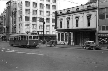
Photograph - Black & White Photograph/s, Melbourne & Metropolitan Tramways Board (MMTB), mid 1970's
Black and white photograph of Z1 in bound to Spencer St in Bourke St Melbourne mid to late 1970's, prior to the implementation of the Bourke St Mall in Feb. 1978 (See also Reg Item 281). Has a W class tram in the background. In the background are buildings for Prouds, the State Savings Bank of Victoria and McEwans. Note the Street Seller of tickets on the tram stop and the "No Centre Turn" sign on a pole at the back of the tram. Photo source unknown.trams, tramways, z class, mmtb, bourke st, tram z 1 -
 Bacchus Marsh & District Historical Society
Map, Plan of Survey of Part of Crown Allotment 9, Parish of Korkuperrimul, 1890
This map documents a transfer of an allotment of land in Clarke Street Bacchus Marsh in 1890. Clarke Street is located on the eastern side of Bacchus Marsh not far from Main Street and Crook Street. It is now known as Candeloro Street. The map indicates J. Booth as the owner of the land and H. Simpson as the occupier. Next to this allotment is a an allotment of land owned by J. Elmore,Single page map showing Crown allotment 9, Parish of Korkuperrimul, County of Bourke. Scale 100 feet to inch. Part of a set of maps which are pasted into a bound volume containing 76 maps or plans in total. High resolution digital image stored on BMDHS computer network. At bottom of map: I hereby certify that I have made this survey expressly for the purpose of an application under the Transfer of Land Statute that this plan is correct. Barry B???, Lic. Surveyor, 16.10.90bacchus marsh victoria maps, clarke street bacchus marsh maps -
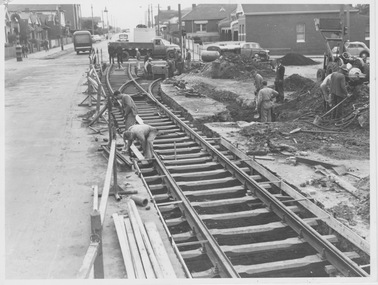 Melbourne Tram Museum
Photograph - Track laying Nicholson St and Holden St, 1956
Photograph shows construction of new track including a turnout to the right. While no notes are attached, landmarks indicate the photograph is of Nicholson St, North Fitzroy looking northward over Holden St/Brunswick Rd with a track connection to the remaining single track in those streets. This line was constructed in 1956 to replace the bus service.Yields information about construction of Bourke st electric line Black and white photograph with blue biro measurements on rearHandwritten notes read: '16, 8 2/16 x 6 1/8'm&mtb, track laying, nicholson st, east brunswick, holden st -
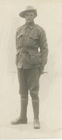 Bendigo Historical Society Inc.
Postcard - BLANCHE SLY POSTCARD COLLECTION, 1900 - 1920
Postcard Album of Blanche Sly. Postcards stored in Folder 81 (49 postcards). 1403.1 - 1403.28 Grey linen look cover with picture of a small sailing boat pasted centre front pf cover. Partly torn sticker on lower LH corner. Blanche Victoria SLY Born: 11 Oct 1890, daughter of William and Hannah Sly Address: 1913; Loddon Vale Address: 1980; 100 Barnard Street Bendigo Died: Bendigo 12 June 1982, buried Bendigo G3 William Sly: Born: 1856 at Smythesdale, Victoria Married in Victoria in 1887; Hannah Theilman Died: Bendigo 1937, buried Bendigo G1 Hannah Sly Nee Theilman Born: 1866 Married in Victoria in 1887; William Sly Died: Bendigo 1948, buried Bendigo G3 See additional Research .Postcard Album of Blanche Sly containing 49 postcards. See 1403 B&W studio photo of Alex McPherson in soldier's uniform Swiss Studios, Bourke St, Melbourne . Addressee -None Sender -Alex McPherson Dated June 26th, 1916 postcard, collector, blanche sly -
 Greensborough Historical Society
Poster - Planning Document, Shire of Diamond Valley et al, Subdivision Plan # 1018 - Parish of Nillumbik, County Bourke, Crown Allotment 4 Section 15, and Crown Allotment B Section 12, Eltham North, 1981-1982
Subdivision Plan # 1018 - Parish of Nillumbik, County Bourke, Crown Allotment 4 Section 15, and Crown Allotment B Section 12, Eltham North. This subdivision plan includes Ryans Road (also known as Government Road) and St Clems Street. The developer for this subdivision is Taunton Developments and the Surveyors are Fisher Cleeland Turner & Dwyer Vic, Surveyors and Engineers.An example of hard copy subdivision plans from the Greensborough area. Mainly from the Shire of Diamond Valley era (1964-1994).Plan (single sided) mounted on heavy card. Stamped and handwritten Council permissions, dates and other details. subdivision plans, shire of diamond valley, taunton developments -
 Greensborough Historical Society
Poster - Planning Document, Shire of Diamond Valley et al, Subdivision Plan # 1026 - Parish of Nillumbik, County Bourke, Crown Allotment B Section 12, Eltham North, 1981-1984
Subdivision Plan # 1026 - Parish of Nillumbik, County Bourke, Crown Allotment B Section 12, Eltham North. This subdivision plan includes Ryans Road (also known as Government Road) and St Clems Street. The developer for this subdivision is Taunton Developments and the Surveyors are Fisher Cleeland Turner & Dwyer Vic, Surveyors and Engineers.An example of hard copy subdivision plans from the Greensborough area. Mainly from the Shire of Diamond Valley era (1964-1994).Plan (single sided) mounted on heavy card. Stamped and handwritten Council permissions, dates and other details. subdivision plans, shire of diamond valley, taunton developments -
 Greensborough Historical Society
Poster - Planning Document, Shire of Diamond Valley et al, Subdivision Plan # 1044 - Parish of Nillumbik, County Bourke, Crown Allotment B Section 12, Eltham North, 1981-1987
Subdivision Plan # 1044 - Parish of Nillumbik, County Bourke, Crown Allotment B Section 12, Eltham North. This subdivision plan includes Weidlich Road and St Clems Street. The developer for this subdivision is Taunton Developments and the Surveyors are Fisher Cleeland Turner & Dwyer Vic, Surveyors and Engineers.An example of hard copy subdivision plans from the Greensborough area. Mainly from the Shire of Diamond Valley era (1964-1994).Plan (single sided) mounted on heavy card. Stamped and handwritten Council permissions, dates and other details. subdivision plans, shire of diamond valley, taunton developments -
 Canterbury History Group
Photograph - Maling Road shops and environs, Stuart Warmington, 1993
Photographs recording interiors and exteriors of Canterbury shops, shopkeepers and Federation details of architecture. Section A -Maling Road shops, south side - 87 coloured photographs taken by Jan Pigot in 1993.|Section B- Maling Road shops, north side - 88 coloured photographs taken by Jan Pigot in 1993.|Section C- Bryson Street shops - car park - 4 coloured photographs taken by Jan Pigot in 1993-4.|Section D- Canterbury shops and streetscapes - 76 coloured photographs taken by Stuart Warmington c.1995.|Section E- Maling Road shops, north side - 27 coloured photographs taken by Stuart Warmington c. 1995.|Section F- Maling Road shops, north and south side - 24 coloured photographs taken by Stuart Warmington 1995.|Section G- Plaques and Signs in Canterbury - 14 coloured photographs taken by Jan Pigot c. 1994.maling road, canterbury, shops, shopkeepers, hel> f, petroro> tony, bourke> francis, d'annibale> grace, buckley> june, buckley> ken, godfrey, greengrocers, newsagents, gift shops, furniture restorers, florists, nurseries (plants), cake shops, cafes, butchers -
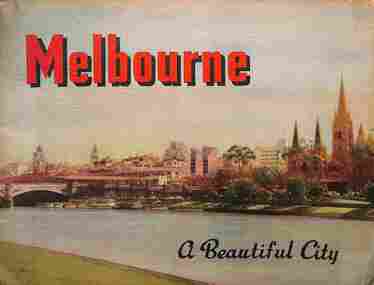 Melbourne Tram Museum
Book, Nucolorvue Publishing, "Melbourne - a Beautiful City", c1953
Published by Nucolorvue Productions of Mentone Melbourne, c1953 featuring colour photos of many locations in Melbourne, including an introduction. Has photos of Melburne landmarks, Collins St, Flinders St, Bourke St (with cable tram track), Flinders St Station, trams in streets, (W2 389, W5 777) St Kilda Road, the various parks, Royal Melbourne Hospital, St Kilda Beach, Yarra River, and Elizabeth St.Demonstrates a Nucolorvue production about Melbourne in the early 1950s.Book - 36 pages, colour printed, centre stapled. Printed on stippled paper.Has the stamp of "Queensland Book Depot, 61 Adelaide St Brisbane" on the inside front cover and pencil notes.mmtb, trams, tramways, souvenirs, melbourne, travel books -
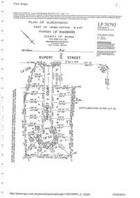 Ringwood and District Historical Society
Document - Subdivision Plan, LP76792 Part of Crown Portions 19 & 20A, Parish of Ringwood, County of Bourke, Vol 8382 Fol 140 - 1967
LANDATA Land Victoria plan printout dated 2010Map includes Rupert Street and Prospect Court, Ringwood. -
 Melbourne Tram Museum
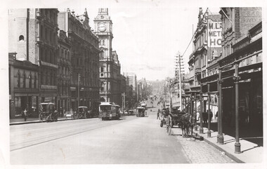
Photograph - Bourke St looking east from near Queen Street, c1900
Photograph shows a scene looking east along Bourke St from near Queen St. Has a number of cable trams in the view, one sign written Clifton Hill, along with several horse-drawn carts. Has signs for T Warburton, W T Henley's Telegraph works, Bryants Hotel, and the Metropolitan Hotel. The GPO is in the background.Yields information about cable trams in Bourke St and the buildings near Elizabeth St c1900.Black and white photograph with notes on the rear. Has the number "64" in pencil in top right-hand corner and "H2172".tramways, cable trams, bourke st -
 Ithacan Historical Society
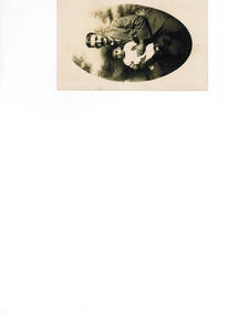
Photograph, Whitney Bros. Electric Studios, Studio photograph of a man and a child, C1920s
Many studio photographs such as this would have been taken to send back to family and friends left behind in Ithaca and other parts of the world.A sepia photograph in an oval outline of a man holding a little child on his knee. The photograph is in post card format.Printed on the back: WHITNEY BROS/ELECTRIC STUDIOS/118 BOURKE ST/MELBOURNE AUSTRALIA/CORRESPONDENCE/ADDRESS.whitney bros, electric studios, unknown -
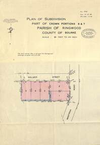 Ringwood and District Historical Society
Map - Plan of Subdivision, Part of Crown Portions 6 & 7, Parish of Ringwood, County of Bourke - 1960
Copy of land title map on light cardboard backing showing layout and size of 5 residential allotments in Walmer Street and Wantirna Road, Ringwood, Victoria.Ref. 3725 Date 15-8-1960 Amended 7-9-1960. Little & Brosnan, Licensed Surveyors & Engineers, 422 Little Collins Street, Melbourne. Telephone MU 5111. -
![Document - Photocopy, Survey Field Notes of Part of Crown Portion 13, Section 4 at Eltham, Parish of Nillumbik, County of Evelyn [Bourke sic], 30 September 1949](/media/collectors/4f729f7b97f83e03086018a5/items/6869da03f3688aa02254c5c2/item-media/6869da22f3688aa02254c6da/item-fit-380x285.jpg) Eltham District Historical Society Inc
Eltham District Historical Society IncDocument - Photocopy, Survey Field Notes of Part of Crown Portion 13, Section 4 at Eltham, Parish of Nillumbik, County of Evelyn [Bourke sic], 30 September 1949
Portion of land bounded by: Main Road, Arthur Street, Dudley Street Application 21718 Erwin Dillon, Licensed Surveyor, 30 September 1949map, neil webster collection, survey plan, surveyor field notes, 1949, application 21718, arthur street, dudley street, main road eltham -
 Melbourne Tram Museum
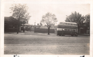
Photograph - Clifton Hill depot - double deck bus, Frank Shennen, 26/2/1941
Photograph shows a view from the street of Clifton Hill depot with cable trailers and a double deck No. 225 passing the depot in Queens Parade Clifton Hill. Photo by Frank Shennen 26/2/1941. Photo taken after the closure of the Bourke St lines in Oct. 1940.Yields information about Clifton Hill cable tram depot or car house and the use of double deck buses. Black and white photograph with notes on the rear and Negative.On rear in pencil "Clifton Hill cable car depot showing trams in yard and new bus in foreground 26/2/1941. 3399 Truck Bus FS. Has measurements and number "169" in pencil in top right hand corner.tramways, cable trams, clifton hill, double deck buses, bus 225 -
Glen Eira Historical Society
Document - Grange Road, 77, Glen Huntly
This file contains 4 items about the purchase and construction of this property: 1/ The original contract of sale of land dated 25/09/1936 for Gertrude & Hulbert Gorrie situated on the corner of Grange and Neerim Road. 2/ The original typed building agreement dated 25/09/1936 between the contractor Ernest F Barnard and the purchasers Mr & Mrs Hulbert Gorrie. 3/ The original blueprint plan of a brick villa at the corner of Grange & Neerim Road for Mr & Mrs Hulbert Gorrie. Dated 25/09/1936. 4/ The original specification for the dwelling on the corner of Grange & Neerim Road, Glen Huntly for Mrs Gertrude Gorrie & Mr Hulbert Hopetoun Gorrie by builder Ernest F Barnard.barnard ernest f, gorrie gertrude, gorrie hulbert hopetoun, hobart john bertram, coorigil road, carnegie, holloway st, ormond, chemists, parish of prahran, caulfield county of bourke, building agreement, brick houses, builders, plans, architectural drawings, grange road, glen huntly, holloway street, ormond, emma street, grange road, neerim road, gorrie h.h, gorrie gertrude, gorrie hulbert h, legal documents, barnard ernest franklin, e. j. & h. amos, hintons nursery, real estate agents, murrumbeena, caulfield -
 Ringwood and District Historical Society
Document, Plan of Subdivision - Part of Crown Portion 5, Parish of Ringwood, County of Bourke - (Undated)
Map showing layout of 4 numbered allotments coloured red and land coloured blue appropriated or set aside for drainage and sewerage puposes.Map includes Nelson Street and Ringwood Street, Ringwood, Vic. -
 Bendigo Historical Society Inc.
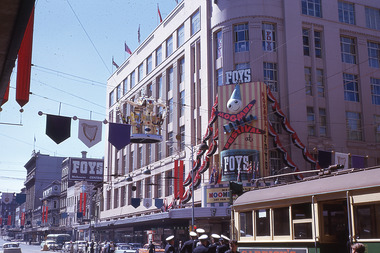
Slide - Mouat Crawford Collection: Farming Life in the Wimmera, c1963
... mouat crawford collection wimmera melbourne bourke ...Flags and banners adorn the street and pennants on the roofs, there is also a large crown above the road. Markings Decorations Bourke & Swanston Sts. Melb. for Moomba and Royal Visit 1963. Used as a teaching aid.Kodakmouat crawford collection, wimmera, melbourne bourke and swanson streets, royal visit, foys