Showing 23059 items matching "creek"
-
 Stawell Historical Society Inc
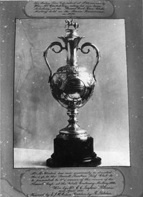
Photograph, Stawell Turf Club a Silver Cup won at Pleasant Creek race club meeting held at Stawell race course 1878
Stawell Turf Club a Silver Cup won at Pleasant Creek race club meeting held at Stawell race course 1878. Valued 40 pounds. Won by Wm McClinock Esq riding his own horse "Salisbury"stawell sport -
 Falls Creek Historical Society
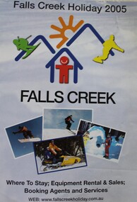
Booklet - Falls Creek Holiday 2005
Part of an annual marketing campaign, this booklet was designed to provide information for planning a holiday at Falls Creek for the winter of 2005. It includes details about activities, facilities and accommodation in the Village as well as maps and contact information to make necessary bookings.This item is important as it documents seasonal activities at Falls Creek Alpine Resort An A4 sized marketing booklet, including images and advertising information printed in colour and black and white.falls creek marketing, falls creek 2005, falls creek accommodation -
 Eltham District Historical Society Inc
Photograph, Tess Justine (Nillumbik Shire Council), Construction work on replacement of Murray's Bridge over the Diamond Creek, Eltham North, 31 Mar 2022
Construction work on replacement of Murray's Bridge over the Diamond Creek on the Diamond Creek Trail Mary (Sweeney) Murray and John Wright Murray selected 80 acres, Lot C Section 16 and Lot 5 Section 17 Parish of Nillumbik, under an occupation license in 1866. John died in 1867 and freehold was granted to his son John in 1873. The farm was known as ‘Laurel Hill’. John Junior was an Eltham Shire councillor and sometime president from 1887 up until 1897. He added Lot A Section 16 to the farm in ca1888. John and his younger brother James arranged to rent/purchase Lot B Section 17, across Diamond Creek to the west, in ca1900. It appears that John and James farmed separately for a few years, with a new homestead built for James ad family on the high point of Lot B Section 17 in ca1910. John sold off Lot 5 Section 17 in 1912. When John died in 1912 James took over the land on both sides of the Diamond Creek. The old homestead on the west side of the Creek disappeared. A farm bridge over Diamond Creek from this period may have been located close to the northern boundary of the farm. John Langlands, owner of the farm known as ‘Ihurst’ on the west side of Diamond Creek to the south of the Murray’s land, died in 1907. In 1909 his land was then subdivided into 100 lots to become the ‘Glen Park Estate’. Other similar subdivisions of nineteenth century farms around Eltham in this period included the ‘Franktonia (or Beard’s) Estate’ to the northeast and ‘Bonsack’s Estate’ between Eltham and Greensborough. Soon after the opening of the railway extension line from Eltham to Hurstbridge in 1912, Glen Park and nearby residents including James Murray agitated for a railway station or siding to be located half-way between Eltham and Hurstbridge, so that the Glen Park residents who used the railway daily did not have to walk into the Eltham or Hurstbridge stations. Some believed Coleman’s Corner (opposite Edendale Farm) was an appropriate spot for the platform. James Murray was among those who thought the railway should be located on his land, closer to half-way between Eltham and Hurstbridge stations. The Railways Commissioners warned that the locals would have to fund these works themselves. The Glen Park Estate residents initially had difficulty accessing Eltham by road, with only an old low-level bridge over Diamond Creek at the south end of their estate. A new timber trestle bridge across the creek, now on Wattletree Road, was opened in 1915. Road access to the north was gained in 1927 when the new Murray’s Road, which crossed the Murray’s land, was built. Residents continued to agitate for a Glen Park station. By 1926 the Railways Commissioners’ preferred site was on the Murray’s land. They arranged an estimate of cost of a full-length platform. The estimate was too much for the locals, who in 1928 argued unsuccessfully for a shorter and hence cheaper platform. By 1929 Murray had agreed to donate the land, but the locals would still have to fund the works. Murray decided, unilaterally it would appear, to commence work on a timber trestle road bridge over Diamond Creek to link the new Murray Road to the proposed station. Late in 1929 he stopped work on the bridge, for reasons unknown, but started work again and completed the bridge in 1931. There is no further newspaper evidence of the campaign for the Glen Park station until 1939, when Murray and another local, Mr Maxwell, met the Railways Commissioner. The Glen Park locale now included 45 homes on the west side of the creek and 20 on the Eltham side. Most of the residents used the train every day. The Commissioner remained adamant that only a full-length platform could be built for safety reasons. It appears the campaign dissolved at this point. The increasing move to cars may have had an impact. There is no evidence of Murray’s bridge ever being connected to Murray’s Road, or of it having wide use for any purpose by locals. James Murray died in 1947 and the farm was taken over by his son James (Jim). Jim started to sell off parts of the farm in the 1980s, retaining a few acres around the ca1910 homestead and building a new house there. Recreation reserves were established along the creek. In ca1990 Murray’s bridge was renovated with steel girders as part of a bike/pedestrian path in the reserve. The old farmhouse was demolished in ca2014. Born digital image (5)diamond creek (creek), diamond creek trail, murrays bridge, ‘laurel hill’, john wright murray, mary (sweeney) murra, john murray jnr, james murray, john langlands, ‘ihurst’, ‘glen park estate’, beard's estate, franktonia, bonsack's estate, glen park estate, glen park railway station -
 Eltham District Historical Society Inc
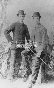
Photograph, Possibly William and Harold Sinclair of Diamond Creek
Twin sons of Harry Sinclair who came to the district from Scotland in 1860. William and Harry were born 25 Feb 1869 in Diamond Creek. William died 12 Sep 1943 at Heidelberg and Harry died 1947 at GreensboroughBlack and white copy of photo printed on glossy photographic paper 30.5 x 40.5 cm (12 x 16 inch); image size approx. 18.5 x 28 cmdiamond creek, harold sinclair, henry colling sinclair, henry sinclair, william alexander sinclair, william sinclair -
 Lorne Historical Society
Domestic object - Whisky Bottle, Moggs Creek Whisky bottle
The Moggs Creek Moving Clickers Society wee responsible for perpetuating the hoax that Sir Samuel Moggs discovered Aireys Inlet before the arrival of the First Fleet. In 1959 they erected a statue to Sir Samual Moggs and also made this whisky bottle.Brown glass whisky bottle sealed with cork and red wax. The black and white printed label identifies it as Moggs Lighthouse , Very Old Matured Whisky dated 1763. Distilled by United Moggs Distillery Unlimited, Aireys Inlet Australia. moggs creek, sir samuel moggs -
 Clunes Museum
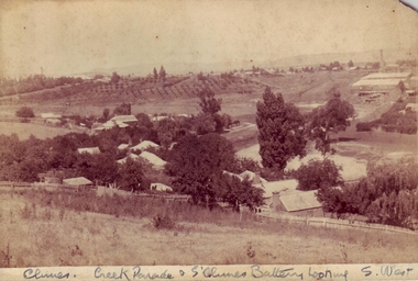
Photograph, BAWDEN PHOTOGRAPHER
SEPIA PHOTOGRAPH OF CREEK PARADE, CLUNES, AND SOUTH CLUNES BATTERYCLUNES CREEK & CLUNES BATTERY LOOKING SOUTH WESTlocal history, photography, photographs, clunes landscape -
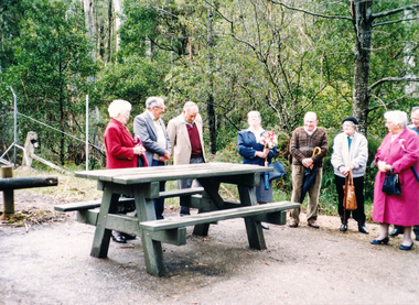 Eltham District Historical Society Inc
Photograph, Dedication of picnic table at Wilks Creek Bridge, Marysville by Marysville Historical Society, 13 October 1993, 13/10/1993
Wilks Creek Bridge was built in 1870. It was last used for heavy vehicle traffic in 1980 and left to decay until it was demolished in 2008. The last remnants of the timber structure were destroyed in the Black Saturday bushfire of 7 February 2009. [from EDHS Newsletter No. 93, November 1993:] OTHER NEWS A small group of members represented the Society at the opening of the picnic ground at the historic Wilks Creek Bridge at Marysville. The event included the launching of a booklet by our friend Ann Thomas on the history of the bridge which was located on the old Yarra Track coaching route between Eltham and Woods Point. Ann has donated a copy of the booklet to our Society.Two colour photographsactivities, marysville, wilks creek bridge -
![Photograph - Digital image, House corner Diamond Creek and St Helena Roads [Greensborough], 02/05/2013](/media/collectors/4f729f5697f83e03086015b8/items/5729b8962162f108e8de2d43/item-media/5729b8f42162f108e8de30fe/item-fit-380x285.jpg) Greensborough Historical Society
Greensborough Historical SocietyPhotograph - Digital image, House corner Diamond Creek and St Helena Roads [Greensborough], 02/05/2013
This photograph of the corner Diamond Creek and St Helena Roads was taken in 2013 to show changes over 40 years, based on Ron Reynold’s sketches in the 1973 publication 'Greensborough and Greenhills' published by Cypress Books. The house on the corner is the subject of one sketch in the book.Digital copy of colour photograph.greensborough and greenhills, st helena road greensborough, diamond creek road greensborough, ron reynolds -
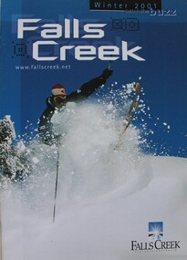 Falls Creek Historical Society
Booklet - Falls Creek Winter 2001 - Catch the Buzz
Part of an annual marketing campaign, this booklet was designed to provide information for planning a holiday at Falls Creek for the winter of 2001. It includes details about activities, facilities and accommodation in the Village as well as contact information to make necessary bookings. The slogan for 2001 was "Catch the Buzz".This item is important as it documents seasonal activities at Falls Creek Alpine Resort An A4 sized marketing booklet, including images and advertising information printed on glossy paper.skiing, ski, falls creek, victoria, school holidays, winter, snow, winter sport, 1990s, marketing, graphic design -
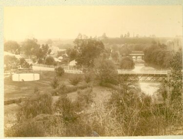
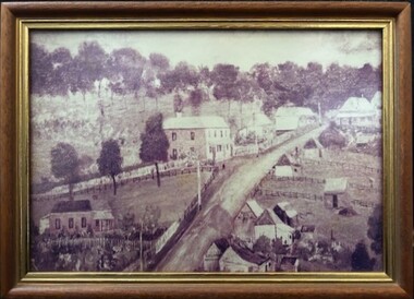 Greensborough Historical Society
Photograph - Photograph (Framed), St Helena and Diamond Creek Roads Greensborough 1889, 1889
A view of Greensborough township 1889, painted from the corner of St Helena Road and Diamond Creek Roads. This copy has been cropped from the original to show lower Main Street and Marble hall. The original of this painting is owned by Greensborough Primary School.From the John Mackey collection. this item was displayed at the offices of Ryan, Mackey and Kelly, solicitors, Main Street Greensborough.Small timber-framed photograph of road and houses, sepia.greensborough, main street greensborough, marble hall greensborough, arthur elliott, john mackey -
 Falls Creek Historical Society
Booklet - 1991 Falls Creek Ski School
An information booklet promoting programs at the Falls Creek Ski School for 1991. It emphasises the "Triple S" way of conducting lessons - Safe, Simple and Stylish". The different kinds of lessons and programs are clearly explained as well as the Ski School class levels. The booklet is endorsed by Qantas.This item is important because it documents seasonal activities at Falls Creek Alpine ResortA small booklet combining information and images printed on glossy paper.falls creek marketing, falls creek ski school, ski lessons, winter in falls creek -
 Falls Creek Historical Society
Booklet - Falls Creek 2003 - Where Fun Falls
Part of an annual marketing campaign, this booklet was designed to provide information for planning a holiday at Falls Creek for the winter of 2003. It includes details about activities, facilities and accommodation in the Village as well as contact information to make necessary bookings. The slogan for 2003 was "Where Fun Falls".This item is important as it documents seasonal activities at Falls Creek Alpine Resort An A4 sized marketing booklet, including images and advertising information printed on glossy paper.ski, victoria, falls creek 2003, falls creek marketing -
 Eltham District Historical Society Inc
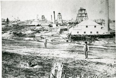
Photograph - Digital Photograph, Alan King, Site of the Diamond Creek Gold Mine, 28 December 2007
The largest gold mine in the area originated from a find in 1862. The mine was closed January 20, 1915 when a fire destroyed nearly all the above ground plant. Published: Nillumbik Now and Then / Marguerite Marshall 2008; photographs Alan King with Marguerite Marshall.; p75 Beneath Mine Hill, as locals call it, runs a network of tunnels once of central importance to the fledgling township of Diamond Creek. These are relics of gold mines, which transformed early Diamond Creek.1 The tiny settlement of about 20 families soared to more than 200 because of gold. For around 50 years, from 1862, gold mining was Diamond Creek’s major source of employment. On September 7, 1854 The Argus newspaper reported a find of a four pound (1.8kg) gold nugget in Nillumbik (an early name for Diamond Creek). Exactly where, is not known.2 The largest mine in the district, the Diamond Creek Gold Mine, apparently originated from a find in 1862. It is said Joe and Dave Wilson were visiting former tailor then cook, Charles Orme, at the southern end of Fraser Street. Sitting on a stump outside the front gate on land belonging to Dr A. E. Phipps the Wilsons found a vein of gold-bearing quartz, which led to the discovery of four quartz reefs varying in width to eight inches (20cm), running north and south. A reef found at the foot of the hill opposite Challenger Street became the Union Mine. This reef was traced south to Allendale Road where a small mine began operations.3 Other smaller mines later operated as well. Dr Phipps immediately began to mine and also built the Diamond Reef Hotel as a boarding house for miners. But Charles Orme, who owned the land alongside, leased his mine to Dr Phipps probably because of insufficient funds and business skills. By mid 1865 the mine had produced 2530 ounces of gold – a 100% profit on the original outlay. Of course there were problems. When the local dam dried up a Blake pump was installed to draw water from the creek. The Union Mine operated under the Diamond Creek Gold Mine management except when disputes sometimes resulted in separate management. However disagreements had to be resolved as the Union Mine depended on Diamond Creek Gold Mine pumps to remove underground water from common reefs. In 1912 the main shaft of about 380 yards (350m) employed 200 men recovering an average of 5000 ounces (141.7kg) of gold a year. But not everyone did well out of gold. Records of failed mining companies in the Victorian Public Record Office, reveal that owner Dr Phipps leased his Right to others. Companies came and went over the next 40 years, most sponsored by Melbourne businessmen who sold shares to gullible locals and then became insolvent. Although there were some good profits, financial returns were haphazard until 1905. Some local residents, who were share holders in short- term companies, became well-known names in modern Diamond Creek such as Scott, Haley, Butler, Alder, Ryan, Wadeson, Reeves, Alston, Paul and Edwards. Gold mining was brought to a disastrous end on January 20, 1915 at 3 pm, when fire destroyed nearly all the above-ground plant. Fortunately no lives were lost. But reopening the mine was almost impossible because of the increasing depth of water in the main shaft. The closed mine destroyed the livelihood of 200 families and the debris took many years to clear.4 In 1946 the Diamond Creek Gold Mine was reopened by the Golden Hind Mining Company, but money ran out before the 600 feet (182.8m) or so of water could be removed. Gold remains in the mine but enormous capital would be needed to buy the land, equipment and to remove the water. Today 12 known sealed shafts along the ridge of the hills on private property extend west for around one kilometre from the corner of Fraser and Haley Streets, crossing Norma and Fyffe to Dering Streets. As recently as 1987, heavy rains revealed a former Union Mine shaft in the Georgiadis family Fyffe Street back yard.5 Allendale Mine, south of Allendale Road, is still open and one of the Union Mine’s main drives (horizontal excavation) remains unsealed, on the Creek Reserve.This collection of almost 130 photos about places and people within the Shire of Nillumbik, an urban and rural municipality in Melbourne's north, contributes to an understanding of the history of the Shire. Published in 2008 immediately prior to the Black Saturday bushfires of February 7, 2009, it documents sites that were impacted, and in some cases destroyed by the fires. It includes photographs taken especially for the publication, creating a unique time capsule representing the Shire in the early 21st century. It remains the most recent comprehenesive publication devoted to the Shire's history connecting local residents to the past. nillumbik now and then (marshall-king) collection, diamond creek, diamond creek mine, fraser street, gold mining, james cook drive, mine hill -
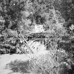
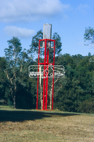 Eltham District Historical Society Inc
Slide - Photograph, Sensory Integration Invention A, Cathy Smith (1999), Fergusons Paddock, Arthurs Creek Road, Hurstbridge, c.Nov. 2001
Sensory Integration Invention A, by Cathy Smith public art sculpture, commissioned by Nillumbik Shire Council, in Fergusons Paddock,12 Arthurs Creek Road Hurstbridge was officially unveiled in 1999. Councillors Penny Mullinar and Margaret Jennings in attendance. "Smith's work has strong references to humans' sensory and practical relationship with the land through the built environment. Wind entering the structure's tubing operates like a flute, generating sounds such as bird calls that resonate into the surrounding wetland areas." Source: Highlights from the Nillumbik Public Art Collection, NSC, n.d. Part of a slide show presentation "A Trip Down the Diamond Creek" by Russell Yeoman to the Eltham District Historical Society meeting of 14 Nov. 200135mm colour positive transparency Mount - Black and Whiteart in public places, arthurs creek road, cathy smith, ferguson's paddock, hurstbridge, public art, sensory integration invention a -
 Eltham District Historical Society Inc
Book, Things You Didn't Know about the Railway: Eltham, Diamond Creek, Wattle Glen, Hurstbridge, 2017
Update of 1st editon by Jock Ryan published in March 2003. 2nd edition (Revised) Nillumbik Historical Society December 2017 Brief history of the agitation and eventual extension and opening of the Hurstbridge Railway line from Eltham to Diamond Creek, Wattle Glen to Hurstbridge, which was opened in June 1912. Includes details of events thereafter including Wattle Day and Railway accidents. Profusely illustrated with black and white photographs from the collection of the Nillumbik Historical Society (Diamond Creek). Agitation for a railway extension began in 1888 when a meeting was held at Arthurs Creek to press for the construction of a railway line from Heidelberg to Kinglake. The Chairman Mr Charles Draper said this was necessary because this was the best fruit growing district in Victoria. Mr Cameron M.P. pointed out that whatever route the line took it would have to follow the Diamond Valley from Eltham. At the same time another meeting was pressing for the line to be extended to Queenstown (St Andrews). However when detailed surveys were made it was discovered that the only possible route was to Hurstbridge because of the hills. In 1912 the railway was opened terminating at Hurstbridge. Bound with orange covers. Text with black and white illustrations. 30 pages.hurstbridge railway line,diamond creek,wattle glen,hurstbridge, nillumbik historical society -
Creswick Campus Historical Collection - University of Melbourne
Photograph - Photographs of VSF students from the play "Gold of Creswick's Creek", Gold of Creswick's Creek, 1952
Two black and White photographs featuring VSF students who played the 'Miners' in the Creswick Centenary Committee production of "Gold of Creswick's Creek". Eric Bachelard, John Opie, Phil Garth, Robert Orr, Stuart Murray, David Anderson, Leo Teller, Ross May.Photographs -
 Stawell Historical Society Inc
Photograph, Pleasant Creek Cross Reef Quartz Mining Company c1885
Pleasant Creek Cross Reef Quartz Mining Company c1885. In foreground of the photo is the North Cross No2 Shaft, in the centre is the North Cross No1 Shaft. In the background is the Oriental Mine and just behind that is the Extended Cross Reef Mine and on the horizon is the Crown Cross United Mine.B/W Mining Scene with two gentlemen in ridged poses.stawell mining -
 Stawell Historical Society Inc
Photograph, The Reef Hotel Pleasant Creek 1858 - 1861 -- note, no Bullock team as in Rees painting
The Reefs Hotel Pleasant Creek. 1858 - 1861 (note, no Bullock team as in Rees painting) Three windlasses over mineshafts can be seen, two on the left and one in front of the assembly hall. Some horse driven Whims can be seen in the background above the Assembly Hall.One of earliest known photographs of Pleasant CreekSeveral buildings in mining area with trees in background, one building labelled The Reefs Hotel. Spoil heaps in foreground with other mining activities . Number of people visible in street.stawell -
 Clunes Museum
Photograph, 1939
THIS PHOTOGRAPH WAS TAKEN DURING EASTER CENTENARY CELEBRATIONS 1939ORIGINAL PHOTOGRAPH OF BUTTER FACTORY & BRIDGE OVER CREEK.BRIDGE OVER CREEK, PHOTOGRAPH TAKEN FACING TOWARDS THE PARK.local history, photography, photographs, bridges -
 Ringwood and District Historical Society
Photograph, Ringwood Rifle Club. Rebuilding viaduct Jumping Creek Reserve after bushfires,1962
Typed on back of photograph, "Ringwood Rifle Club. Rebuilding viaduct Jumping Creek Reserve after bushfires 1962. Brian Pump, not knowing the sleepers had been burned away went to drive across and his truck went straight down. Club captain A. Williams wearing felt hat and smoking cigarette." -
 Clunes Museum
Photograph, APPROX. 1900
THE PHOTOGRAPH WAS TAKEN FROM CREEK PARADE GOVERNMENT BRIDGE CRESWICK ROAD AND BUTTER FACTORY BRIDGE ACROSS TULLAROOP CREEK. GASWORKS..1 ORIGINAL SEPIA LANDSCAPE OF CLUNES MOUNTED ON CARDBOARD. GOVERNMENT AND JUBILEE BRIDGES ACROSS CRESWICK CREEK. GASWORKS NEARBY. .2 BLACK AND WHITE COPY OF THE ABOVE PHOTOGRAPH PRINTED ON GLOSS PHOTOGRAPHIC PAPER .3 HAND COLOURED POSTCARD PHOTOGRAPH OF THE ABOVE PHOTOGRAPH .4 TWO POSTCARDS WITH SAME PICTURE .5 FOUR SMALL PHOTOGRAPH COPIES WITH SAME PICTURE.1 ON BACK OF PHOTOGRAPH GASWORKS, BRIDGES AND CREEK. 1900 .3 ON FRONT OF POSTCARD GOV. BRIDGE CLUNESlocal history, photography, photographs, bridges and buildings -
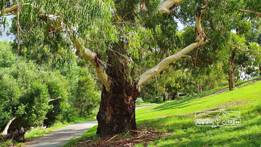 Eltham District Historical Society Inc
Photograph, Alison Delaney, Significant Eucalyptus tree, Diamond Creek Trail, Alistair Knox Park, Eltham, 21 Feb 2020
This tree is a significant tree located beside the Diamond Creek Trail in Alistair Knox Park. It was identified as the same tree in earlier photos from the 1980s. This images was taken just before the COVID-19 pandemic hit and the tree also has been tagged with grafitti on its trunk.alistair knox park, diamond creek trail, grafitti, significant tree -
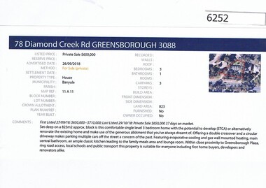 Greensborough Historical Society
Advertising Leaflet, Barry Plant Greensborough, 78 Diamond Creek Road Greensborough, 26/09/2018
Real estate advertisement for 78 Diamond Creek Road Greensborough, a 3 bedroom house. Originally listed by Barry Plant, this house was sold 03/11/2018 for $630,000 by Nelson Alexander. Previous sales: June 2007 for $290,250; April 1983 $49,500 and June 1979 for $34,000.Real estate advertisement black text and colour photographdiamond creek road greensborough -
 Sunbury Family History and Heritage Society Inc.
Photograph, Jacksons Creek
The photograph of the waterfall tumbling over rocks in the Jacksons Creek are a feature downstream from the Macedon Street bridge and Craiglee when the there has been high rainfall. The steep escarpment on the LHS leads to Jacksons Hill and the line of trees in the distance are growing along Macedon Street (Sunbury Road).After heavy rainfall, Jacksons Creek rises suddenly and small trickles over the rocky outcrops become fast flowing waterfalls.A non-digital sepia photograph backed onto thick cardboard of a waterfall tumbling over rocks in a river with a high escarpment rising up from the watercourse. There are rocky outcrops across the hillside with a pipe down the hillside. jacksons creek, jackson hill, waterfalls, rivers -
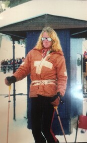 Falls Creek Historical Society
Photograph - Alex Warrender - Ski Patrol
Alexander Warrender was born in Melbourne and educated at Melbourne Grammar and Geelong Grammar School. He began skiing at an early age and spent many winters at Falls Creek. After leaving school in 1973, Alex decided to live at Falls Creek and went on to join the Falls Creek Ski Patrol. He was quickly promoted to second in charge of the Patrol aged 20 and was one of the first fulltime paid patrollers on the mountain. Alex also played in the band at the Frying Pan in the Bowl. Tragically he died in a car accident on the Oxley Road leaving the mountain on 23rd of August 1976. His funeral was a St John’s church in Toorak, and ashes were scattered on The Summit in a ski formation of the letter A by his young brother Simon and members of the Patrol. After Alex’s death, a small hut was constructed at the top of the Summit in 1980 which houses first-aid equipment used by Ski Patrol where a plaque was placed by Ski Patrol. Each year since Alex’s death, at 5pm on the 23rd of August, Falls Creek Ski Patrol gathers at this hut along with members of the Falls Creek community to remember Alex and other patrollers no longer here. This annual event is referred to as the Warrender Night, and celebrates the spirit of the Ski Patrol. Members of the Ski Patrol also raised funds and materials to build The Alexander Warrender Memorial Ski Patrol Base located on the ridge to the left at the top of Eagle Chair. It was officially opened by Alex’s mother Pamela on August 23rd 1990.This image is significant because they capture the image of one of Falls Creek's First Official Ski Patrollers whose memory is still honoured today.A colour photo of Alex Warrender Ski Patroller at Falls Creek and a framed photo of a group of Ski Patrollers and friends who attended Warrender Night in 2008Beneath framed image: Ski Patrol Evening 23 August 2008 - Summit Hut - Falls Creek Thank you from The Warrnedersalex warrender, falls creek ski patrol -
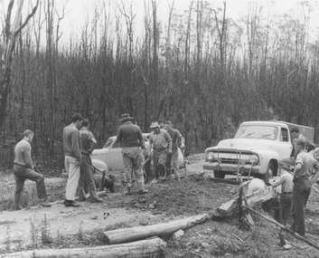
 Eltham District Historical Society Inc
Negative - Photograph, J.A. McDonald, Eltham-Diamond Creek Road, 21 Sep 1959
Bridge construction Eltham-Diamond Creek road over the Diamond Creek (Wattletree Road), Eltham, September 1959 After some delay in receiving funds, work started on the bridge approaches in early September 1959. Traffic was still using the old bridge upstream. On Sunday, 20 September 1959, heavy flooding occurred in the stream and at 3:53 pm the old bridge was washed out. This photo was taken the day after. The bridge was originally built as a replacement for an older private bridge built by a man named Foley around 1880. In 1911 Heidelberg and Eltham agreed to share the costs to build a new bridge. Construction began in June 1915 and it was officially opened by Cr. Taylor on Cup Day, November 1915.Record of various Shire of Eltham infrastructure works undertaken during the period of 1952-1962 involving bridge and road reconstruction projects, sometimes with Eltham Shire Council Project Reference numbers quoted. It was during this period that a number of significant improvements were made to roads and new bridges constructed within the shire that remain in place as of present day (2022). In many situations, the photos provide a tangible visible record of infrastructure that existed throughout the early days of the Shire. The album was put together by or under the direction of the Shire Engineer, J.A. McDonald.infrastructure, shire of eltham, bridge construction, bridge, diamond creek (creek), eltham, eltham north, glen park bridge, 1959-09-21, flood damage, wattletree road bridge -
Ballarat Heritage Services
Ceramic - Photograph - Colour, Ceramic Plate by Graham Masters of Sweenies Creek Pottery
Graham MASTERS Graham Masters is a potter based at Sweenies Creek, just outside Bendigo, Victoria. He specialises in a patented technique of low relief stoneware depicting Australian animals and landscapes. He obtained a Diploma of Art and Design in Ceramics from the Bendigo Institute of Technology in 1973, then operated a pottery for a year in Bendigo, before becoming an employee, then a partner at Maldon Pottery, Maldon, Victoria, with Neville Wilson and Thomas Metcalf. He left Maldon to set up his own pottery at Sweenies Creek in 1983 and has been there over 20 years. In 2000 Graham Masters started working at Bendigo pottery, and is one of five in the business, specialising in large works such as vases, platters and wine barrels, all handmade on the pottery wheel. graham masters, sweenies creek pottery, ceramics -
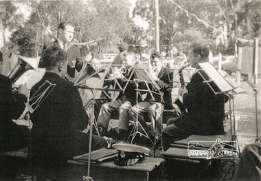 Eltham District Historical Society Inc
Photograph, Shire of Eltham Brass Band at Arthurs Creek, 1 Sep 1962, 1/9/62
Photocopies of three images of Shire of Eltham Brass Band at Arthurs Creek 1. View of players 2. View of players 3. Group shot - Names Back Row L to R: Jeff Mundy; Laurie Bulmer; Jock Malcolm; Stan Manhive; Ron Howell; Alan Meredith; Warren Ward (hidden) Front Row L to R: Frank Brook; Alf Mundy; Karl Michaelson; Ted Barnes;Alan Luscombebands, brass, music, arthurs creek, eltham brass band -
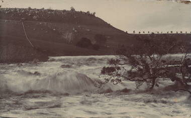
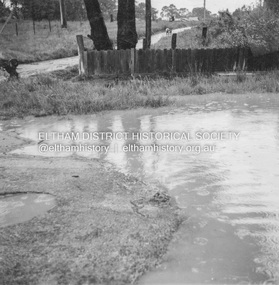 Eltham District Historical Society Inc
Album - Photograph, J.A. McDonald, Eltham-Diamond Creek Road, 21 Oct. 1953
18 October 1956 Flooding on Diamond Creek 17th October 1956 (not max.) This view is looking southwest along Railway Parade (now present-day Gastons Road) past Mrs Lucy Egan's house now owned by the Bakos family, purchased by Mrs Heather Bakos in 1960Record of various Shire of Eltham infrastructure works undertaken during the period of 1952-1962 involving bridge and road reconstruction projects, sometimes with Eltham Shire Council Project Reference numbers quoted. It was during this period that a number of significant improvements were made to roads and new bridges constructed within the shire that remain in place as of present day (2022). In many situations, the photos provide a tangible visible record of infrastructure that existed throughout the early days of the Shire. The album was put together by or under the direction of the Shire Engineer, J.A. McDonald.infrastructure, road construction, shire of eltham, bridge construction, eltham north, floods, floodwater, glen park bridge, 1956-10-18, diamond creek (creek), eltham, railway parade, wattletree road, wattletree road bridge, gastons road -
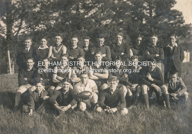 Eltham District Historical Society Inc
Photograph, Diamond Creek Football Club, c.1906
Thomas Edmund Fielding (1874-1957) was a significant member of the Diamond Creek Footbal Club during the early 1900s. Son of Robert Fielding (1820-1891) and Jemima Whatmough (1840-1926) and grandson of Plenty River pioneers Robert Whatmough (1815-1887) and Mary Hill (1813-1881)diamond creek football club, thomas edmund fielding, tom fielding collection, sports