Showing 3677 items
matching gold mininging
-
 Marysville & District Historical Society
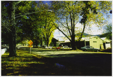
Photograph (Item) - Colour photograph, 1984
... gold mining... tried gold mining at Woods Point but found it too difficult. He ...A colour photograph of Barton Bros Store in Murchison Street in Marysville in Victoria.A colour photograph of Barton Bros Store in Murchison Street in Marysville in Victoria. Thomas John Barton was born in 1836 in Gloucestershire and after his father died in 1850 arrived in Melbourne in 1852 along with his mother, adult sisters, younger brothers, his uncle, his uncle's wife Suzanna and their family. Thomas tried gold mining at Woods Point but found it too difficult. He then partnered with Ewen Hugh Cameron to provide the miners with meat. In 1864 they purchased a plot of land in Marysville and set up a butchers/abattoirs and from there began their business of taking supplies to the miners at the nearby Woods Point and Jamieson goldfields. In 1865 the business was firmly established and Thomas married Selina Croker at Heidelberg and brought her back to Marysville. Their first home was 'The Chestnuts', which included the store, and was situated on the town side next to the Steavenson River. Sadly, in 1876 Selina died of complications after giving birth to their sixth child. Thomas was in need of a nanny to care for his six children, including the newborn baby, and so he employed Emily Ada Sparke, who is the eldest daughter of the local school teacher. Thomas and Emily subsequently marry in 1878 and they go on to have a further 10 children over the next several years. Thomas assisted in the establishment of the first school in Marysville in 1870 and remained a very active member of the community including as a Councillor for the Shire of Healesville, Shire President and he was also appointed as a Justice of the Peace. Thomas died in Carlton in 1911. After their father's death, his sons Fred and Frank took over the family business, which was then known as Barton Bros Store which continued to operate until sometime in the 1970's.marysville, victoria, barton's store, thomas john barton, ewen hugh cameron, woods point, jamieson, gold mining, goldfields, selina croker, the chestnuts, emily ada sparke, shire of healesville, fred barton, frank barton, barton bros store, francis adam barton, frederick john barton, photograph, barton's garage, barton bros stables -
 Marysville & District Historical Society
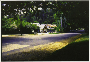
Photograph (Item) - Colour photograph, 1984
... gold mining... tried gold mining at Woods Point but found it too difficult. He ...A colour photograph of the Marysville Garage in Marysville in Victoria.A colour photograph of the Marysville Garage in Marysville in Victoria. This garage was once owned by the Barton Family who were one of Marysville's early pioneering families. Thomas John Barton was born in 1836 in Gloucestershire and after his father died in 1850 arrived in Melbourne in 1852 along with his mother, adult sisters, younger brothers, his uncle, his uncle's wife Suzanna and their family. Thomas tried gold mining at Woods Point but found it too difficult. He then partnered with Ewen Hugh Cameron to provide the miners with meat. In 1864 they purchased a plot of land in Marysville and set up a butchers/abattoirs and from there began their business of taking supplies to the miners at the nearby Woods Point and Jamieson goldfields. In 1865 the business was firmly established and Thomas married Selina Croker at Heidelberg and brought her back to Marysville. Their first home was 'The Chestnuts', which included the store, and was situated on the town side next to the Steavenson River. Sadly, in 1876 Selina died of complications after giving birth to their sixth child. Thomas was in need of a nanny to care for his six children, including the newborn baby, and so he employed Emily Ada Sparke, who is the eldest daughter of the local school teacher. Thomas and Emily subsequently marry in 1878 and they go on to have a further 10 children over the next several years. Thomas assisted in the establishment of the first school in Marysville in 1870 and remained a very active member of the community including as a Councillor for the Shire of Healesville, Shire President and he was also appointed as a Justice of the Peace. Thomas died in Carlton in 1911. After their father's death, his sons Fred and Frank took over the family business, which was then known as Barton Bros Store which continued to operate until sometime in the 1970's.marysville, victoria, barton's store, thomas john barton, ewen hugh cameron, woods point, jamieson, gold mining, goldfields, selina croker, the chestnuts, emily ada sparke, shire of healesville, fred barton, frank barton, barton bros store, francis adam barton, frederick john barton, photograph, barton's garage, barton bros stables, marysville garage -
 Marysville & District Historical Society
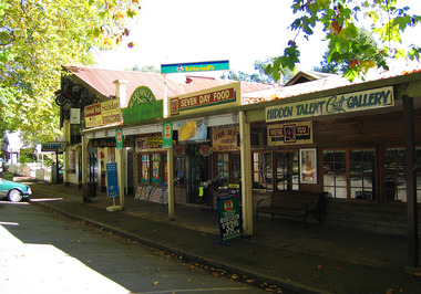
Photograph (Item) - Colour photograph, Unknown
... gold mining... and their family. Thomas tried gold mining at Woods Point but found it too ...A colour photograph of the former Barton Bros' Store in Marysville in Victoria.A colour photograph of the former Barton Bros' Store in Marysville in Victoria. This became the We're 4 You supermarket. Thomas John Barton was born in 1836 in Gloucestershire and after his father died in 1850 arrived in Melbourne in 1852 along with his mother, adult sisters, younger brothers, his uncle, his uncle's wife Suzanna and their family. Thomas tried gold mining at Woods Point but found it too difficult. He then partnered with Ewen Hugh Cameron to provide the miners with meat. In 1864 they purchased a plot of land in Marysville and set up a butchers/abattoirs and from there began their business of taking supplies to the miners at the nearby Woods Point and Jamieson goldfields. In 1865 the business was firmly established and Thomas married Selina Croker at Heidelberg and brought her back to Marysville. Their first home was 'The Chestnuts', which included the store, and was situated on the town side next to the Steavenson River. Sadly, in 1876 Selina died of complications after giving birth to their sixth child. Thomas was in need of a nanny to care for his six children, including the newborn baby, and so he employed Emily Ada Sparke, who is the eldest daughter of the local school teacher. Thomas and Emily subsequently marry in 1878 and they go on to have a further 10 children over the next several years. Thomas assisted in the establishment of the first school in Marysville in 1870 and remained a very active member of the community including as a Councillor for the Shire of Healesville, Shire President and he was also appointed as a Justice of the Peace. Thomas died in Carlton in 1911. After their father's death, his sons Fred and Frank took over the family business, which was then known as Barton Bros Store which continued to operate until sometime in the 1970's.marysville, victoria, barton's store, thomas john barton, ewen hugh cameron, woods point, jamieson, gold mining, goldfields, selina croker, the chestnuts, emily ada sparke, shire of healesville, fred barton, frank barton, barton bros store, francis adam barton, frederick john barton, photograph, barton's garage, barton bros stables, marysville garage, we're 4 you supermarket -
 Marysville & District Historical Society
Photograph (Item) - Colour photograph, Unknown
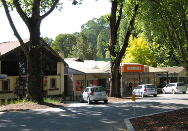
... gold mining... and their family. Thomas tried gold mining at Woods Point but found it too ...A colour photograph of the former Barton Bros' Store in Marysville in Victoria.A colour photograph of the former Barton Bros' Store in Marysville in Victoria. This changed hands several times over the years. It was a Foodworks supermarket when the building, along with most of Marysville, was destroyed in the 2009 Black Saturday bushfires. Thomas John Barton was born in 1836 in Gloucestershire and after his father died in 1850 arrived in Melbourne in 1852 along with his mother, adult sisters, younger brothers, his uncle, his uncle's wife Suzanna and their family. Thomas tried gold mining at Woods Point but found it too difficult. He then partnered with Ewen Hugh Cameron to provide the miners with meat. In 1864 they purchased a plot of land in Marysville and set up a butchers/abattoirs and from there began their business of taking supplies to the miners at the nearby Woods Point and Jamieson goldfields. In 1865 the business was firmly established and Thomas married Selina Croker at Heidelberg and brought her back to Marysville. Their first home was 'The Chestnuts', which included the store, and was situated on the town side next to the Steavenson River. Sadly, in 1876 Selina died of complications after giving birth to their sixth child. Thomas was in need of a nanny to care for his six children, including the newborn baby, and so he employed Emily Ada Sparke, who is the eldest daughter of the local school teacher. Thomas and Emily subsequently marry in 1878 and they go on to have a further 10 children over the next several years. Thomas assisted in the establishment of the first school in Marysville in 1870 and remained a very active member of the community including as a Councillor for the Shire of Healesville, Shire President and he was also appointed as a Justice of the Peace. Thomas died in Carlton in 1911. After their father's death, his sons Fred and Frank took over the family business, which was then known as Barton Bros Store which continued to operate until sometime in the 1970's.marysville, victoria, barton's store, thomas john barton, ewen hugh cameron, woods point, jamieson, gold mining, goldfields, selina croker, the chestnuts, emily ada sparke, shire of healesville, fred barton, frank barton, barton bros store, francis adam barton, frederick john barton, photograph, barton's garage, barton bros stables, marysville garage, we're 4 you supermarket, foodworks supermarket, 2009 black saturday bushfires -
 Marysville & District Historical Society
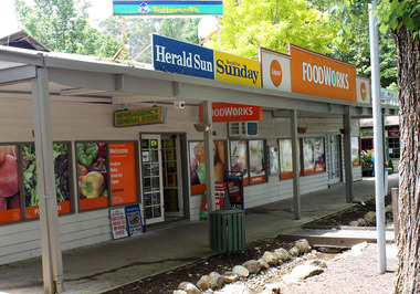
Photograph (Item) - Colour photograph, Unknown
... gold mining... uncle's wife Suzanna and their family. Thomas tried gold mining ...A colour photograph of the former Barton Bros' Store in Marysville in Victoria.A colour photograph of the former Barton Bros' Store in Marysville in Victoria. This eventually became a Foodworks supermarket. The building, along with most of Marysville, was destroyed in the 2009 Black Saturday bushfires. Thomas John Barton was born in 1836 in Gloucestershire and after his father died in 1850 arrived in Melbourne in 1852 along with his mother, adult sisters, younger brothers, his uncle, his uncle's wife Suzanna and their family. Thomas tried gold mining at Woods Point but found it too difficult. He then partnered with Ewen Hugh Cameron to provide the miners with meat. In 1864 they purchased a plot of land in Marysville and set up a butchers/abattoirs and from there began their business of taking supplies to the miners at the nearby Woods Point and Jamieson goldfields. In 1865 the business was firmly established and Thomas married Selina Croker at Heidelberg and brought her back to Marysville. Their first home was 'The Chestnuts', which included the store, and was situated on the town side next to the Steavenson River. Sadly, in 1876 Selina died of complications after giving birth to their sixth child. Thomas was in need of a nanny to care for his six children, including the newborn baby, and so he employed Emily Ada Sparke, who is the eldest daughter of the local school teacher. Thomas and Emily subsequently marry in 1878 and they go on to have a further 10 children over the next several years. Thomas assisted in the establishment of the first school in Marysville in 1870 and remained a very active member of the community including as a Councillor for the Shire of Healesville, Shire President and he was also appointed as a Justice of the Peace. Thomas died in Carlton in 1911. After their father's death, his sons Fred and Frank took over the family business, which was then known as Barton Bros Store which continued to operate until sometime in the 1970's.marysville, victoria, barton's store, thomas john barton, ewen hugh cameron, woods point, jamieson, gold mining, goldfields, selina croker, the chestnuts, emily ada sparke, shire of healesville, fred barton, frank barton, barton bros store, francis adam barton, frederick john barton, photograph, barton's garage, barton bros stables, marysville garage, we're 4 you supermarket, foodworks supermarket, 2009 black saturday bushfires, in neutral restaurant -
 Federation University Historical Collection
Booklet, Leigh River Tunnel Gold Mining Co. Syndicate Books
... Leigh River Tunnel Gold Mining Co. Syndicate Books...Leigh River Tunnel Gold Mining Co.... on this subject! Richard Squire Leigh River Tunnel Gold Mining Co ...Richard Squire was a student at the School of Mines Ballarat In 1905 Richard Squire was manager of the West Berry Consols at Allendale, and developed an improved system of mine ventilation, which was supported in "The Age." He was successful in combating and remedying the gas and ventilation troubles of the Deep Mines of Creswick and Allendale Districts after all had failed. MINE MANAGERS’ ASSOCIATION. Ballarat Branch. ... Mr R. B. Squire, manager of the West Berry Consols, at Allendale, submitted a paper detailing what he had done tor the betterment of ventilation in the alluvial mines of Smeaton and Mary borough districts- Members gave Mr Squire every credit for the results that he claimed to have effected; the adoption of his ideas had testified to their value to mine-owners. It was painted out, however, that for want of a thorough debate of the subject with experienced men the author had unwittingly included some general statements that required modifying in some points and extending in others, in justice to other workers among the earlier and the present day managers of mines. It was decided to invite the author to meet a sub-committee on this subject!Oblong booklets with green covers of syndicate share certificates .1 Dark Green cover 1923 all used .2 Light Green cover 1924 four pages used .3 Light Green cover 1924 all used .4 Light Green Cover 1924 all used .5 light Green Cover 1918 - 1919 four pages used .1 Front cover torn but has notes written on it. .2 Leigh River Tunnel G 21st Call written on front .3 Leigh River Tunnel G 22nd Call written on front .4 Leigh River Tunnel G 23rd Call and figures written on front .5 3 shares isued out of this book, Leigh River Share Book No. 16 A 30 written on front richard squire, leigh river tunnel gold mining co., syndicate book, hy peacock -
Federation University Historical Collection
Newspaper, Our Heroes (The Courier Special Edition, 25 April 2015)
... Australian Mining Corps Frank Golding Abert Coates Pompey Elliott ...A special edition of the Courier newspaper to commemorate the cententary of the ANZAC landing at Gallipoli.non-fictionanzac, courier, gallipoli, ballarat arch of victory, albert lambert, frank lambert, henry lambert, william lambert, ballarat ranger barracks, australian mining corps, frank golding, abert coates, pompey elliott, alick white, alexander henry white, thomas ellefsen, catherine mcwilliam, albert green -
Federation University Historical Collection
Book, Digging for Gold: A guide to researching family and local history in Victoria's Central Goldfields, 1988
... E.J. Barker Library (top floor) Mount Helen goldfields Gold ...Yellow covered book of 121 pagesnon-fictiongold, mining, genealogy, family history, local history, localities, historical societies -
 Flagstaff Hill Maritime Museum and Village
Book - Biography, Flynn of The Inland
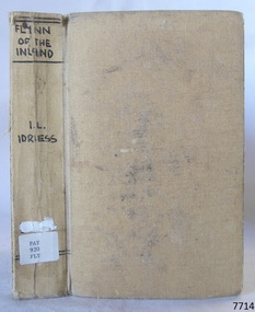
... then went gold mining in Papua New Guinea, buffalo shooting ...This item is from the ‘Pattison Collection’, a collection of books and records that was originally owned by the Warrnambool Mechanics’ Institute, which was founded in Warrnambool in 1853. By 1886 the Warrnambool Mechanics’ Institute (WMI) had grown to have a Library, Museum and Fine Arts Gallery, with a collection of “… choice productions of art, and valuable specimens in almost every branch and many wonderful national curiosities are now to be seen there, including historic relics of the town and district.” It later included a School of Design. Although it was very well patronised, the lack of financial support led the WMI in 1911 to ask the City Council to take it over. In 1935 Ralph Pattison was appointed as City Librarian to establish and organise the Warrnambool Library as it was then called. When the WMI building was pulled down in 1963 a new civic building was erected on the site and the new Warrnambool Library, on behalf of the City Council, took over all the holdings of the WMI. At this time some of the items were separated and identified as the ‘Pattison Collection’, named after Ralph Pattison. Eventually the components of the WMI were distributed from the Warrnambool Library to various places, including the Art Gallery, Historical Society and Flagstaff Hill. Later some were even distributed to other regional branches of Corangamite Regional Library and passed to and fro. It is difficult now to trace just where all of the items have ended up. The books at Flagstaff Hill Maritime Village generally display stamps and markings from Pattison as well as a variety of other institutions including the Mechanics’ Institute itself. RALPH ERIC PATTISON Ralph Eric Pattison was born in Rockhampton, Queensland, in 1891. He married Maude Swan from Warrnambool in 1920 and they set up home in Warrnambool. In 1935 Pattison accepted a position as City Librarian for the Warrnambool City Council. His huge challenge was to make a functional library within two rooms of the Mechanics’ Institute. He tirelessly cleaned, cleared and sorted a disarrayed collection of old books, jars of preserved specimens and other items reserved for exhibition in the city’s museum. He developed and updated the library with a wide variety of books for all tastes, including reference books for students; a difficult task to fulfil during the years following the Depression. He converted all of the lower area of the building into a library, reference room and reading room for members and the public. The books were sorted and stored using a cataloguing and card index system that he had developed himself. He also prepared the upper floor of the building and established the Art Gallery and later the Museum, a place to exhibit the many old relics that had been stored for years for this purpose. One of the treasures he found was a beautiful ancient clock, which he repaired, restored and enjoyed using in his office during the years of his service there. Ralph Pattison was described as “a meticulous gentleman whose punctuality, floorless courtesy and distinctive neat dress were hallmarks of his character, and ‘his’ clock controlled his daily routine, and his opening and closing of the library’s large heavy doors to the minute.” Pattison took leave during 1942 to 1945 to serve in the Royal Australian Navy, Volunteer Reserve as Lieutenant. A few years later he converted one of the Museum’s rooms into a Children’s Library, stocking it with suitable books for the younger generation. This was an instant success. In the 1950’s he had the honour of being appointed to the Victorian Library Board and received more inspiration from the monthly conferences in Melbourne. He was sadly retired in 1959 after over 23 years of service, due to the fact that he had gone over the working age of council officers. However he continued to take a very keen interest in the continual development of the Library until his death in 1969. WARRNAMBOOL PUBLIC LIBRARY The Warrnambool Mechanics’ Institute (WMI) was formed by a voluntary community group in 1863, within six years of Warrnambool’s beginnings, and its Reading Room opened in 1854. The WMI operated until 1963, at which time it was one of the oldest Mechanics’ Institutes in Victoria. Mechanics’ Institutes offered important services to the public including libraries, reading rooms and places to display and store collections of all sorts such as curiosities and local historical relics. In 1886 a Museum and Fine Arts Gallery were added to the WMI and by the beginning of the 20th century there was also a billiards room and a School of Art. By this time all Mechanics’ Institutes in country Victoria had museums attached. Over the years the Warrnambool Mechanics’ Institute Library was also known as the Warrnambool Public Library the Warrnambool Library and the Free Library. Early funding from the government was for the “Free Library”. The inscription in a book “Science of Man” was for the “Warrnambool Public Library”, donated by Joseph Archibald in 1899. Another inscription in the book “Catalogue of Plants Under Cultivation in the Melbourne Botanic Gardens 1 & 2, 1883” was presented to the “Warrnambool Library” and signed by the author W.R. Guilfoyle. In 1903 the Warrnambool Public Library decided to add a Juvenile Department to library and stock it with hundreds of books suitable for youth. In 1905 the Public Library committee decided to update the collection of books and added 100 new novels plus arrangements for the latest novels to be included as soon as they were available in Victoria. In July 1911 the Warrnambool Council took over the management of the Public Library, Art Gallery, Museum and Mechanics’ Institute and planned to double the size of the then-current building. In 1953, when Mr. R. Pattison was Public Librarian, the Warrnambool Public Library’s senior section 10,000 of the 13,000 books were fiction. The children’s section offered an additional 3,400 books. The library had the equivalent of one book per head of population and served around 33 percent of the reading population. The collection of books was made up of around 60 percent reference and 40 percent fiction. The library was lending 400 books per day. In 1963 the Warrnambool City Council allocated the site of the Mechanics’ Institute building, which included the Public Library, Museum and Art Gallery, for the new Municipal Offices and the Collections were dispersed until 1971. The Warrnambool Library took over the Mechanics’ Institute Library’s holdings on behalf of the Warrnambool City Council. Since the closure of the Warrnambool Mechanics’ Institute the exact location and composition of the original WMI books and items has become unclear. Other materials have been added to the collection, including items from Terang MI, Warrnambool Court House and Customs House. Many of the books have been identified as the Pattison Collection, named after the Librarian who catalogued and numbered the books during his time as Warrnambool Public Librarian in the time before the Mechanics’ Institute closed. It seems that when Warrnambool became part of the Corangamite Regional Library some of the books and materials went to its head office in Colac and then back to Warrnambool where they were stored at the Art Gallery for quite some time. Some then went to the Warrnambool Historical Society, some stayed at the Art Gallery and some were moved to Flagstaff Hill Maritime Village. The various stamps and labels on the books held at Flagstaff Hill show the variety of the collection’s distribution and origin. The books in the collection at Flagstaff Hill Maritime Village date from the 1850’s to the late 1950’s and include rare and valuable volumes. Many of the books are part of the “Pattison Collection” after the Warrnambool’s Public Librarian, Mr. R. Pattison. The Pattison Collection, along with other items at Flagstaff Hill Maritime Village, was originally part of the Warrnambool Mechanics' Institute’s collection. The Warrnambool Mechanics’ Institute Collection is primarily significant in its totality, rather than for the individual objects it contains. Its contents are highly representative of the development of Mechanics' Institute libraries across Australia, particularly Victoria. A diversity of publications and themes has been amassed, and these provide clues to our understanding of the nature of and changes in the reading habits of Victorians from the 1850s to the middle of the 20th century. The collection also highlights the Warrnambool community’s commitment to the Mechanics’ Institute, reading, literacy and learning in the regions, and proves that access to knowledge was not impeded by distance. These items help to provide a more complete picture of our community’s ideals and aspirations. The Warrnambool Mechanics Institute book collection has historical and social significance for its strong association with the Mechanics Institute movement and the important role it played in the intellectual, cultural and social development of people throughout the latter part of the nineteenth century and the early twentieth century. The collection of books is a rare example of an early lending library and its significance is enhanced by the survival of an original collection of many volumes. The Warrnambool Mechanics' Institute’s publication collection is of both local and state significance. About Ion L Idriess Ion Llewellyn Idriess was born in Waverley, Sydney, New South Wales on 20th September 1889 and passed away on 6th June 1979 in Mona Vale, Sydney, New South Wales at the age 89. After Idriess finished school he worked in the assay office of Broken Hill Proprietary mine. Both Idriess and his mother had typhoid fever when Ion was about 15 years old and it caused his mother’s death. After spending time with his Grandmother in Sydney he found work on a paddle-steamer and had a relapse of the fever. He then went into the western district of New South Wales where he worked in many different itinerant jobs, including rabbit poisoner, boundary rider, drover, sandalwood harvester, shearer, dingo shooter and opal miner. While opal mining at Lightning Ridge he wrote short stories, about life on the opal fields, for the Bulletin using the name “Gouger”. Idriess then moved to North Queensland in search of gold, tin and sandalwood. He travelled over a great deal of the Cape York Peninsula spending a lot of this travel time with local indigenous people; thus began his lifelong interest in their customs. He then spent time on cattle stations in the Gulf of Carpentaria. In 1914 Idriess travelled to Townsville and enlisted in the 5th Light Horse as a trooper. He became a specialist in sniping and was a spotter for the noted sniper Billy Sing. He saw service in Palestine, Sinai and Turkey. Idriess was wounded at Beersheba and after fighting the Battle of Gaza he was invalided home in March 1918. After recovering from his wounds Idriess again travelled to Cape York Peninsula where he worked with pearlers and missionaries in the Torres Strait Islands. He then went gold mining in Papua New Guinea, buffalo shooting in the Northern Territory of Australia and then exploring in Central and Western Australia. LITERARY WORKS OF IDRIESS In 1928 Idriess settled in Sydney and published the first of his 47 books. In 1931 - “Lasseter’s Last Ride”, became his first best seller. In the years 1932 and 1940 he published three books in each year. “The Cattle King” (1936) and “Flynn of the Inland” (1932) have gone through reprinting forty to fifty times. His last book was published in 1969. Idriess’ books where in general non-fiction and were written in a colourful and immediate story style, taken from life experiences gained during his travels. Idriess was appointed an Officer of the Most Excellent Order of the British Empire (OBE) for his service to literature in 1968. The Warrnambool Mechanics' Institute Collection is primarily significant in its totality, rather than for the individual objects it contains. Its contents are highly representative of the development of Mechanics' Institute libraries across Australia, particularly Victoria. A diversity of publications and themes has been amassed, and these provide clues to our understanding of the nature of and changes in the reading habits of Victorians from the 1850s to the middle of the 20th century. The collection also highlights the Warrnambool community’s commitment to the Mechanics’ Institute, and to reading, literacy and learning in the regions, and proves that access to knowledge was not impeded by distance. These items help to provide a more complete picture of our community’s ideals and aspirations. As with many Mechanics' Institutes in Australia, the one which operated in Warrnambool was established and overseen for many years by key individuals associated with the development of the city itself. The WMI publication collection is historically significant because of its association with local people, places and the key historical themes in the development of Warrnambool of rural development, industry, farming, education, and community. The collection documents and illustrates the changing interests, focus and tastes of Victorians, especially those in regional cities. Generally the individual items in the collection are not particularly rare, as examples of all probably exist in other public collections in Victoria. It is primarily because there are so very few surviving Mechanics' Institute collections in Victoria, which lends this overall collection its significance. Many items in the WMI Collection have the potential to support further research, both as individual objects and through the collection in its entirety. This material is significant for its ability to assist in the interpretation of the history of the area and adds to the general understanding of the development of the township. Many components of the WMI publication collection complement and reinforce the Flagstaff Hill Maritime Museum Collection, the Warrnambool Art Gallery Collection, and that in the Warrnambool Historical Society, and also contribute to a clearer understanding of the original Warrnambool Mechanics' Institute collections. This will greatly enhance the appreciation of the few surviving Mechanics' Institute collections across Victoria, and also in New South Wales. The similarities and differences between the small number of collections that have survived can provide further insights into how the people of Victoria in general, and Warrnambool in particular, constructed a civic culture of adult learning to foster an informed citizenry. The Warrnambool Mechanics' Institute publication collection is of both local and state significance. Flynn of The Inland Author: Ion Idriess Publisher: Angus & Robertson Date: 1932Label on spine cover with typed text PAT 920 FLY Pastedown front endpaper has sticker from Warrnambool Public Library Front loose endpaper has a sticker from Corangamite Regional Library Service warrnambool, shipwrecked-coast, flagstaff-hill, flagstaff-hill-maritime-museum, maritime-museum, shipwreck-coast, flagstaff-hill-maritime-village, shipwrecked-artefact, book, pattison collection, warrnambool library, warrnambool mechanics’ institute, ralph eric pattison, corangamite regional library service, warrnambool city librarian, mechanics’ institute library, victorian library board, warrnambool books and records, warrnambool children’s library, great ocean road, flynn of the inland, ion idriess -
 Flagstaff Hill Maritime Museum and Village
Book - Historical, The Great Boomerang
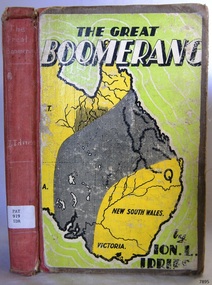
... then went gold mining in Papua New Guinea, buffalo shooting ...This item is from the ‘Pattison Collection’, a collection of books and records that was originally owned by the Warrnambool Mechanics’ Institute, which was founded in Warrnambool in 1853. By 1886 the Warrnambool Mechanics’ Institute (WMI) had grown to have a Library, Museum and Fine Arts Gallery, with a collection of “… choice productions of art, and valuable specimens in almost every branch and many wonderful national curiosities are now to be seen there, including historic relics of the town and district.” It later included a School of Design. Although it was very well patronised, the lack of financial support led the WMI in 1911 to ask the City Council to take it over. In 1935 Ralph Pattison was appointed as City Librarian to establish and organise the Warrnambool Library as it was then called. When the WMI building was pulled down in 1963 a new civic building was erected on the site and the new Warrnambool Library, on behalf of the City Council, took over all the holdings of the WMI. At this time some of the items were separated and identified as the ‘Pattison Collection’, named after Ralph Pattison. Eventually the components of the WMI were distributed from the Warrnambool Library to various places, including the Art Gallery, Historical Society and Flagstaff Hill. Later some were even distributed to other regional branches of Corangamite Regional Library and passed to and fro. It is difficult now to trace just where all of the items have ended up. The books at Flagstaff Hill Maritime Village generally display stamps and markings from Pattison as well as a variety of other institutions including the Mechanics’ Institute itself. RALPH ERIC PATTISON Ralph Eric Pattison was born in Rockhampton, Queensland, in 1891. He married Maude Swan from Warrnambool in 1920 and they set up home in Warrnambool. In 1935 Pattison accepted a position as City Librarian for the Warrnambool City Council. His huge challenge was to make a functional library within two rooms of the Mechanics’ Institute. He tirelessly cleaned, cleared and sorted a disarrayed collection of old books, jars of preserved specimens and other items reserved for exhibition in the city’s museum. He developed and updated the library with a wide variety of books for all tastes, including reference books for students; a difficult task to fulfil during the years following the Depression. He converted all of the lower area of the building into a library, reference room and reading room for members and the public. The books were sorted and stored using a cataloguing and card index system that he had developed himself. He also prepared the upper floor of the building and established the Art Gallery and later the Museum, a place to exhibit the many old relics that had been stored for years for this purpose. One of the treasures he found was a beautiful ancient clock, which he repaired, restored and enjoyed using in his office during the years of his service there. Ralph Pattison was described as “a meticulous gentleman whose punctuality, floorless courtesy and distinctive neat dress were hallmarks of his character, and ‘his’ clock controlled his daily routine, and his opening and closing of the library’s large heavy doors to the minute.” Pattison took leave during 1942 to 1945 to serve in the Royal Australian Navy, Volunteer Reserve as Lieutenant. A few years later he converted one of the Museum’s rooms into a Children’s Library, stocking it with suitable books for the younger generation. This was an instant success. In the 1950’s he had the honour of being appointed to the Victorian Library Board and received more inspiration from the monthly conferences in Melbourne. He was sadly retired in 1959 after over 23 years of service, due to the fact that he had gone over the working age of council officers. However he continued to take a very keen interest in the continual development of the Library until his death in 1969. The Pattison Collection, along with other items at Flagstaff Hill Maritime Village, was originally part of the Warrnambool Mechanics' Institute’s collection. The Warrnambool Mechanics’ Institute Collection is primarily significant in its totality, rather than for the individual objects it contains. Its contents are highly representative of the development of Mechanics' Institute libraries across Australia, particularly Victoria. A diversity of publications and themes has been amassed, and these provide clues to our understanding of the nature of and changes in the reading habits of Victorians from the 1850s to the middle of the 20th century. The collection also highlights the Warrnambool community’s commitment to the Mechanics’ Institute, reading, literacy and learning in the regions, and proves that access to knowledge was not impeded by distance. These items help to provide a more complete picture of our community’s ideals and aspirations. The Warrnambool Mechanics Institute book collection has historical and social significance for its strong association with the Mechanics Institute movement and the important role it played in the intellectual, cultural and social development of people throughout the latter part of the nineteenth century and the early twentieth century. The collection of books is a rare example of an early lending library and its significance is enhanced by the survival of an original collection of many volumes. The Warrnambool Mechanics' Institute’s publication collection is of both local and state significance. About Ion L Idriess Ion Llewellyn Idriess was born in Waverley, Sydney, New South Wales on 20th September 1889 and passed away on 6th June 1979 in Mona Vale, Sydney, New South Wales at the age 89. After Idriess finished school he worked in the assay office of Broken Hill Proprietary mine. Both Idriess and his mother had typhoid fever when Ion was about 15 years old and it caused his mother’s death. After spending time with his Grandmother in Sydney he found work on a paddle-steamer and had a relapse of the fever. He then went into the western district of New South Wales where he worked in many different itinerant jobs, including rabbit poisoner, boundary rider, drover, sandalwood harvester, shearer, dingo shooter and opal miner. While opal mining at Lightning Ridge he wrote short stories, about life on the opal fields, for the Bulletin using the name “Gouger”. Idriess then moved to North Queensland in search of gold, tin and sandalwood. He travelled over a great deal of the Cape York Peninsula spending a lot of this travel time with local indigenous people; thus began his lifelong interest in their customs. He then spent time on cattle stations in the Gulf of Carpentaria. In 1914 Idriess travelled to Townsville and enlisted in the 5th Light Horse as a trooper. He became a specialist in sniping and was a spotter for the noted sniper Billy Sing. He saw service in Palestine, Sinai and Turkey. Idriess was wounded at Beersheba and after fighting the Battle of Gaza he was invalided home in March 1918. After recovering from his wounds Idriess again travelled to Cape York Peninsula where he worked with pearlers and missionaries in the Torres Strait Islands. He then went gold mining in Papua New Guinea, buffalo shooting in the Northern Territory of Australia and then exploring in Central and Western Australia. LITERARY WORKS OF IDRIESS In 1928 Idriess settled in Sydney and published the first of his 47 books. In 1931 - “Lasseter’s Last Ride”, became his first best seller. In the years 1932 and 1940 he published three books in each year. “The Cattle King” (1936) and “Flynn of the Inland” (1932) have gone through reprinting forty to fifty times. His last book was published in 1969. Idriess’ books where in general non-fiction and were written in a colourful and immediate story style, taken from life experiences gained during his travels. Idriess was appointed an Officer of the Most Excellent Order of the British Empire (OBE) for his service to literature in 1968. The Great Boomerang Author: Ion L Idriess Publisher: Angus & Robertson Date: 1948Label on spine cover with typed text PAT 919 IDR Pastedown front endpaper has sticker from Corangamite Regional Library Service warrnambool, shipwrecked-coast, flagstaff-hill, flagstaff-hill-maritime-museum, maritime-museum, shipwreck-coast, flagstaff-hill-maritime-village, shipwrecked-artefact, book, pattison collection, warrnambool library, warrnambool mechanics’ institute, ralph eric pattison, corangamite regional library service, warrnambool city librarian, mechanics’ institute library, victorian library board, warrnambool books and records, warrnambool children’s library, great ocean road, the great boomerang, ion l idriess -
 Greensborough Historical Society
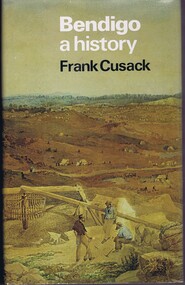
Book, Frank Cusack, Bendigo: a history, 1973
... gold mining... (Vic.) - history gold discoveries victoria gold mining ...A history of Bendigo from before the first gold discovery to the closure of the last mine in 1954.262 p., illus.non-fictionA history of Bendigo from before the first gold discovery to the closure of the last mine in 1954.bendigo (vic.) - history, gold discoveries victoria, gold mining -
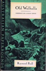 Greensborough Historical Society
Book, Raymond Paull, Old Walhalla: portrait of a gold town, 1963
... gold mining... gold mining The history of Walhalla from its early gold mining ...The history of Walhalla from its early gold mining days.147 p., black and white illustrationsnon-fictionThe history of Walhalla from its early gold mining days.walhalla, mining towns, gippsland, gold mining -
Glenelg Shire Council Cultural Collection
Functional object - Scales - gold weighing, c. 1854
... gold mining... and the scales belonged to him gold mining scales gold rush Brass scales ...Betty Vivian's maternal grandfather was a gold miner at Majorca, near Maryborough Vic and the scales belonged to himBrass scales for gold, in wooden box, with brass weights and gold ready-reckoner bookletgold mining, scales, gold rush -
 Halls Gap & Grampians Historical Society
Photograph - Sepia, C 1900
... Gold mining... William MINING Gold mining Mafeking 1 copy B/W 1 copy sepia 1 ...Mount William Gold Rush Photo taken from Spion Kop looking at western side of My WilliamView of township called Ladysmith George Mason's farmhouse in centre of picture with smoke rising from chimney Seven men in foreground carrying various items eg. shovel, gold pan, swag etc.1 copy B/W 1 copy sepia 1 on displaymining, gold mining, mafeking -
 Halls Gap & Grampians Historical Society
Photograph - Sepia, C 1900
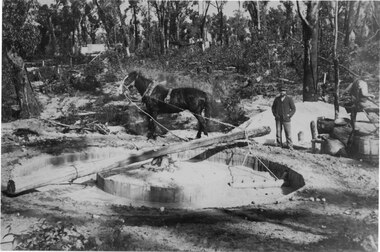
... Gold mining... 117-119 Grampians Road Halls Gap grampians MINING Gold mining ...Photo shows horse connected to gold crushing equipment A circular pit with log braced over centre Two men in foreground1 copy B/W 1 copy Sepiamining, gold mining, mafeking -
 Halls Gap & Grampians Historical Society
Photograph - B/W, C 1900
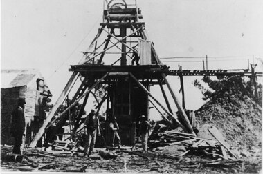
... Gold mining... 117-119 Grampians Road Halls Gap grampians MINING Gold mining ...Photo shows Poppet bead over mine shaft Five men picturedPaper shows 2 copies only 1 at this timemining, gold mining, mafeking -
 Halls Gap & Grampians Historical Society
Photograph - B/W, C 1900
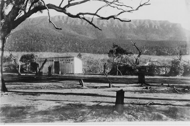
... Gold mining... MINING Gold mining ! copy B/W 1 copy sepia Photo shows tin shed ...Photo shows tin shed with name on front Spion Kop store and My William in background man in centre of photo! copy B/W 1 copy sepiabuildings, shops, mining, gold mining -
 Halls Gap & Grampians Historical Society
Photograph - B/W, C 1900
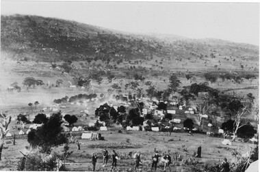
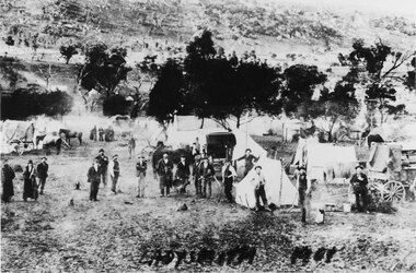
... Gold mining... 117-119 Grampians Road Halls Gap grampians MINING Gold mining ...Photo shows group of miners in front of a cluster of tents and wagons at LadysmithLadysmith 1900 written on frontmining, gold mining, mafeking -
 Halls Gap & Grampians Historical Society
Photograph - B/W, C 1887
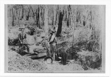
D'Alton's searching for alluvial gold. Photo shows Alfred and Charles D'Alton at Stony Creek Diggings. Charles is on the right and Alfred is on the left. Records 126 and 127 are enlargements from this photo showing each man separately.Photo shows two men working near a sluice. One man is shovelling into a sluice, on a creek and the other is holding an implement. A gold pan rests against a tree.people, d'alton, mining, stoney creek -
 Halls Gap & Grampians Historical Society
Photograph - B/W, C 1900
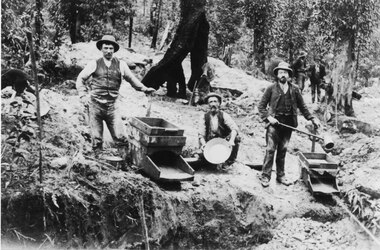
This claim was named Last Chance Unitedphoto shows 3 miners in foreground, 2 men in background. 2 miners are using sluices, 3rd miner is holding gold panmining, mafeking, people -
 Halls Gap & Grampians Historical Society
Photograph - B/W, C 1900
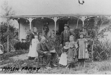
... ' community during Mount William gold rush. PEOPLE Mason MINING ...The Mason family offered their barn for the baking of bread for the 'Ladysmith' community during Mount William gold rush.Photo of the Mason Family outside their home (four adults and three children)people, mason, mining, ladysmith -
 Halls Gap & Grampians Historical Society
Photograph - B/W, C 1900
In early 1900, three Emmett brothers, with support from George Mason, set about following up a report of gold in the area. Confirmation of gold led to a gold rush in June 1900. Traffic from Ararat and Willaura passed Mason's Farm and it was on Mason's land that the first settlement, Ladysmith, sprang up.Road leading to Mt William goldfield 1900. George Mason's farmhouse on right hand side of road.access routes, roads, mining, ladysmith -
 Halls Gap & Grampians Historical Society
Photograph - B/W, C 1900
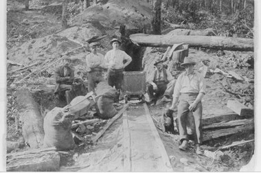
This claim was named "Kangaroo". It had a deep tunnel but produced little gold. The claim was later sold to an Ararat Syndicate which sluiced out the tunnel.Photo of five miners grouped about a trolley at the mouth of a tunnel.mining, mafeking -
 Halls Gap & Grampians Historical Society
Photograph - B/W, C 1887
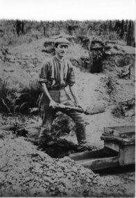
This is an extract/copy of an original photo that showed both Alfred and Charlie D'Alton together. (see Record # 127 for section with Alfred D'Alton and Record # 117 for the entire photo).Photo of Charles D'Alton looking for gold on Stoney Creek. people, d'alton, mining, stoney creek -
 Halls Gap & Grampians Historical Society
Photograph - B/W, C 1887
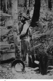
This is an extract/copy of an original photo that showed both Alfred and Charlie D'Alton together. (see Record # 126 for section with Charles D'Alton and Record # 117 for the entire photo).Photo of Alfred D'Alton looking for gold on Stoney Creek.people, d'alton, mining, stoney creek -
 Halls Gap & Grampians Historical Society
Map - Coloured
Background on Bridle Path up Stony Creek Gorge Pre 1840 C. B. Hall, squatter on Mokepilly Run 1841-1842, first European to discover the Fyans Creek valley, the entrance of which became known as Hall's Gap. He later recorded that he followed a number of tracks which he assumed had been made by the Aboriginies and described one as "leading up a wild romantic glen and over on to the source of the Glenelg River". This could well have been the route taken up Stony Creek gorge by the first timber-cutters in this part of the Grampians to the saddle between the Wonderland and Mt. Difficult ranges known as Valley Gap 1850s/60s Timber cutters and shingle splitters were reported to be moving into the eastern side of the Grampians and by the mid 1860s there were a number of families connected to the supplying of timber to Pleasant Creek living in the "Hall's Gap ranges". John Wakeham, the first store owner in Pleasant Creek in 1854, established a timer-mill in upper Stony Creek Gorge in the late 1850s. Wakeham is credited for the clearing and levelling of the first bridle-path up the gorge. 1870s By the mid 1870s the track had been extended over Valley Gap to the Victoria Forest (the upper region of the Victoria Valley). McKeon's bullock team was known to have hauled red gum from the Valley to Stawell in the late 1870s and the 1880s. 1880s In 1887 an article in the Pleasant Creek news describes the Stony Creek Gorge track as "being a ledge alongside the mountain range, formed in the early days with the aid of earth and timber, along which the bullock teams used to travel to Horsham and plains of the Wimmera beyond." 1890s Gold was discovered in the catchment area of Stony Creek and by the end of the 1890s a new track was built from "near the junction of Fyan's and Stony Creeks, up the gorge to the diggings settlement. The mining Department had paid L300 for its construction and, when completed, the track was "three miles and 30 chains in length, the side cuttings at the narrowest part being 10 feet between" and "the watercourses which cross the track at various points" having been "filled up with rocks rolled down the sides of the hills, and consequently there can be no damage caused by bushfires which destroyed the former wooden bridges erected on the old track to Wakeham's saw-mill, the remains of which are still to be seen at the side of the diggings" The article goes on to further describe the track as one which "can with ease travel with a two horse conveyance either up or down" and that the workmen engaged in the construction of the track would be attending "a ball that night at McKeon's farm near the mouth of the gap to celebrate the successful completion of the undertaking". 1900s At what time the bridle path was extended beyond Valley Gap to the Wartook basin on the Mt. Difficult Range has not yet been determined. However, it is known that, by the turn of the century, people were travelling between Halls Gap and the caretakers' residence at Wartook Reservoir along what was now known as the "Bluff Road. Wartook's embankment had been constructed in 1887 and at that time there was already a track from Rosebrook Station homestead (near the present day Wartook Pottery) to the reservoir. Philip Rose owned both Rosebrook and Wartook Stations from the mid 1840s to the late 1850s and had regularly leased the Wartook basin to Cobb & Co. to rest horses there. 1920s Following the war of 1914-1918, tourism really took off in the Grampians, and Halls Gap rapidly grew. People would travel as far as they could on the many tracks then hike to the many lookouts being discovered by local tour guides. This led to the need for access across the range so that horse riders and the increasing number of vehicles could travel between Horsham and Halls Gap. To this end, the Bluff Road was improved and extended on 1929 and at its opening in March, 1930, by Lady Somers it was renamed the Mt. Victory Road.Map of Mt Victory Road and othersaccess routes, mt victory rd, bridle path, roads -
 Halls Gap & Grampians Historical Society
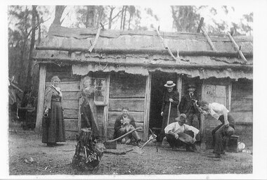
Photograph - B/W, C 1902
... Gold mining... Gold mining "Store at Stoney Creek diggings ?1902. Alice Maria ...The dwelling is said to be the store at the Stoney Creek diggings, with some members of the Langley family. From left Alice Maria Langley, Lucy, ?, ?, Charles Langley (old man) & three friends.Photo shows three women and three men standing and sitting outside a slab hut. The roof of the hut appears to be constructed of bark, held in place by saplings. One of the men is sitting against the side of the hut and is holding a dog. Another man is crouched over a gold pan while an onlooker appears happy with the contents of the pan."Store at Stoney Creek diggings ?1902. Alice Maria Langley, Lucy ? ? Charles Langley (old man) & three friends." written on back in blue pen.people, langley, mining, gold mining -
 Heathcote McIvor Historical Society
Printing Press
... It is significant to heathcote as it has provided the early gold mining ...Used by McIvor Times to print the local newspapters the Rodney Advertiser and McIvor News in Heathcote McIvor 1853-1941It is significant to heathcote as it has provided the early gold mining community of the McIvor District with the current news of the day. Large cast Iron print presshas maufactures details Hopkinson Cope and a badge with 1879 on front with a crest heathcote mcivor newspaper press -
 Eltham District Historical Society Inc
Photograph, Balaclava Open Cut Mine near Whroo Historic Reserve; 9 Oct 1994, 20/11/1994
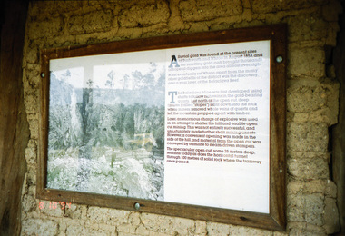
... gold mining... balaclava mine gold mining whroo historic reserve Kodak Gold 100-4 ...Whroo Historic Reserve contains a number of interesting features relating to the former township and gold workings.Record of the Society's history of activities - Spring 1994 excursionRoll of 35mm colour negative film, 4 stripsKodak Gold 100-4shire of eltham historical society, activities, whroo, balaclava hill, balaclava mine, gold mining, whroo historic reserve -
 Eltham District Historical Society Inc
Photograph, Balaclava Open Cut Mine near Whroo Historic Reserve; 9 Oct 1994, 20/11/1994
... gold mining... balaclava mine gold mining whroo historic reserve Kodak Gold 100-4 ...Whroo Historic Reserve contains a number of interesting features relating to the former township and gold workings.Record of the Society's history of activities - Spring 1994 excursionRoll of 35mm colour negative film, 4 stripsKodak Gold 100-4shire of eltham historical society, activities, whroo, balaclava hill, balaclava mine, gold mining, whroo historic reserve