Showing 4511 items
matching historical significance.
-
 Glen Eira Historical Society
Document - Elizabeth Street, 44, Elsternwick
A two page copy of a Caulfield Conservation Study by Andrew Ward, dated 09/1994, on Clifton at 44 Elizabeth Street, Elsternwick. The study includes a brief history of house occupancy, an architectural description, a statement of significance and a black and white photograph (100mm x 154mm) of the exterior of the house. The file also includes an undated and unattributed black and white photograph (90mm x 89mm) of the exterior of Clifton at 44 Elizabeth Street, Elsternwick.elizabeth street, elsternwick, clifton, clifton hill, bent street, davis street, federation style, architectural styles, architectural features, ring charles, bent thomas sir, rippon lea estate, house names, jones percy john, builders, belle vue, edwardian style, ward andrew, st georges road, english domestic revival, elsternwick urban conservation area -
Glen Eira Historical Society
Document - Eversley, Gladstone Parade, 36, Elsternwick
A two page photocopy from the Caulfield Conservation Study by Andrew Ward on the house Eversley at 36 Gladstone Parade. The study includes a brief description of the building, building history, a statement of significance and a black and white photograph (100mm x 155mm) of the exterior of the house. The file also includes a poor quality black and white photograph (88mm x 88mm) of the exterior of the house.architectural features, gladstone parade, nulmore, brampton, eversley, kooyong park estate, clarence street, jackson b thomas, architect, shoobra road, dalrymple william, barbeta augustine, langwill p, ainslie james, henriques frederick, hume c, jackson thomas b, ward andrew -
Glen Eira Historical Society
Document - Fairfield Hall, North Road, 225, Caulfield South
A three page photocopy from the Caulfield Conservation Study by Andrew Ward in 01/1995, on Fairfield Hall at 225 North Road, Caulfield South. The study provides a brief description of the building, its history, a statement of significance and includes two photographs (99mm x 152mm) of the exterior of the building.north road, manair, fairfield hall, caulfield south, caulfield, italianate style, victorian style, architectural styles, mccombie t, keys r, kooyong road, curwan frederick wallis, knight c, aitkin whiting and aitkin solicitors, wall henry, wragge and hearne, younger alexander, younger family, younger avenue, fairfield grove, mansions, ward andrew -
Glen Eira Historical Society
Document - Glenhuntly Road, Elsternwick
Three three page extracts from Andrew Ward’s 1994 Caulfield Conservation Study on commercial buildings in Glen Huntly Road, Elsternwick. The three studies concern Moore’s Buildings 1891 shops at 305-313 Glen Huntly Road, shops at 323-329 Glen Huntly Road and E J Buckeridge’s Buildings 1911 shops at 357-371 Glen Huntly Road. The studies describe the buildings’ architectural features, provide a historical overview and statements of the buildings’ significance, especially in relation to the Land Boom and commercial development between 1890 to the 19020s. All three studies include a black and white photograph (109mm x 152mm; 114mm x 150mm; 110mm x 151mm) of the shop fronts.glen huntly road, moore’s buildings 1891, italianate style, architectural styles, architectural features, verandahs, elsternwick, moore hugh, selwyn street, st georges road, glenmoore, glenmoore estate, corkill french and pugh, jamieson w w, thompson a g, eddy henrietta, valey frank, allen thomas, saddlers, dairy products, green w i, undertakers, delany edward, drapers, herbenstreit huldreich, butcher shops, sincock john, plumbers, allen t, greengrocers, coppel george, painters, dickinson f h, dickinson v, johnson thomas, cole constance, hairdressers, ortner frank, drycleaners, gaffney elodie, ward andrew, long mr, robinson mr, le page mr, byers robert, carter mary, millar c, smythe f c, crook thomas, stancy h, crook’s national stores pty ltd, e j buckeridge’s buildings 1911, kelly walter, staniland grove, buckeridge edward, hannon john, kellett frances, beck miss, armstrong miss, tuck mary, milliners, doherty john, adams herbert, bakeries, perry robert, picture framers, adams clifford, arches, windows, shops, land subdivision, retail trade, property developers, advertising signs -
Glen Eira Historical Society
Document - Athole, Poplar Grove, 18, Carnegie
3 page photocopy of an article on Athole, Poplar Grove, 18, Carnegie, from the Caulfield Conservation Study by Andrew Ward in 01/1995. Article includes a description, brief history, state of significance of Athole, poor quality photography and a bibliography.carnegie, poplar grove, athole, kelleher john thomas, rosstown swamp, market gardens, mackay richard, fish kareen, strathnaver estate, land subdivision, architects, brick houses, stables, greenhouses, architectural styles, architectural features -
Glen Eira Historical Society
Document - Alnwick, Railway Parade,|11-11A,|Murrumbeena
A Caulfield conservation study on ‘Alnwick’, 11 Railway Parade, Murrumbeena, including a description of the exterior of the house and a brief history of the life of its owner, Sir James Brown Patterson. Also includes a statement of significance for Alnwick. Assessment by Andrew Ward dated to March, 1995.railway parade, patterson james, architectural styles, patterson james sir, alnwick, victorian style, murrumbeena -
Glen Eira Historical Society
Document - Ascog (1900), Orrong Road, 10, Elsternwick
A photocopied assessment of Ascog by Andrew Ward as part of the Caulfield Conservation Study in 1994. Assessment includes a description of the house, its condition, integrity, history, including previous owners and a statement of its significance. It includes a poor quality photograph (150mm x 100mm).elsternwick, orrong road, ascog, muir j f, gardenvale estate, hamilton street, riddell parade, plante thomas, grant george, donaldson robert, murdoch thomas, ward andrew, mansions, architectural style, architectural features, victorian style, accountants, produce merchants, land subdivision, residential development -
Glen Eira Historical Society
Document - Balaclava Road, 34, St Kilda East
A photocopy, 3 pages, of the Caulfield Conservation Study report on house formerly known as Noris, Quethiock and also Koala, located at Balaclava Road, 34, Caulfield, by Andrew Ward, dated 04/1993. Includes a description of the house, its condition, integrity, history, a statement of its significance, two black and white photographs (100mm x 70mm, 95mm x 70mm) of the house from different perspectives and a street map (160mm x 90mm) of the surrounding area with handwritten annotations.east louisa, alexandra street, balmoral court, beckwith thomas w, noris, quethiock, koala, wertheimer adolph, taunton james colonel, rosenhain oscar, rosenhain louise, victorian style, mansions, cuming william, ward andrew, cuming smith and co, johnson alfred, architectural styles, architectural features, balaclava road, ward andrew, st kilda east -
Glen Eira Historical Society
Document - Caulfield City Rifle Club No. 119, 294 Glen Huntly Road, Elsternwick
A two page black and white photocopy of a report from the Caulfield Conservation Study on 294 Glen Huntly Road, Caulfield City Rifle Club by Andrew Ward, 09/1994. The report includes a description of the exterior of the property, a brief overview of the history of the building and a statement of its significance. It also includes a black and white photograph (150mm x 100mm) of the exterior of the building, dated 09/1994.caulfield conservation study, architectural features, glen huntly road, ward andrew, caulfield city rifle club, pavey p a -
 Eltham District Historical Society Inc
Photograph, Eltham Courthouse, 730 Main Road, Eltham, 1985, 1985
This building is a fine example of a very early small brick country court house which retains its furnishings and has important associations with the early history of the Eltham township. It was used for Eltham Road Board meetings in the 1860s and later to provide additional school accommodation. It is the oldest public building remaining in Eltham and forms an important group in historic and streetscape terms with the adjoining former police residence. The survival of the furnishings (of unknown origins) is of particular significance given the building's age. This building, and the former police residence beside it, were constructed as a result of a petition by five Eltham residents in 1857. The nearest police were at Heidelberg eight miles away or at the Caledonia Diggings 21 miles away. After the construction of the Court of Petty Sessions at Eltham in 1859-60 (which was designed by the Public Works Department and built by a Mr Duncan for a cost of 536 pounds), it was used for a variety of purposes. Eltham Road Board meetings were held there until 1868 when the board was transferred to Kangaroo Ground and as the Road Board Secretary's office, until this was transferred to Wingrove Cottage in 1867. It was used as an overflow for the Dalton Street School in 1875. According to National Trust records, the Eltham Court House is a relatively rare building type. There are only six other known examples of similar small brick country court houses in the state which have small projecting entry porches and a gabled form. Roll of 35mm colour negative film, 7 stripsFuji 100Neltham, eltham courthouse, main road -
 Eltham District Historical Society Inc
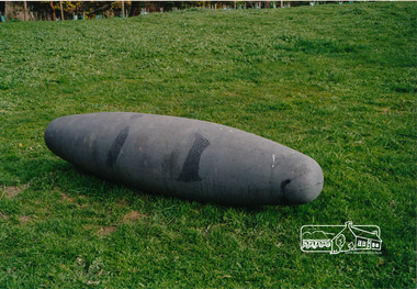
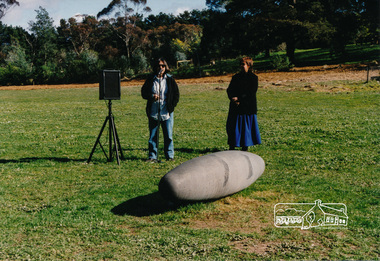
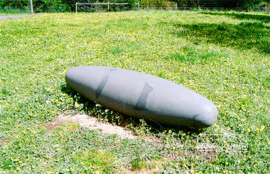
Photograph, Not Just a Pretty Place, Aleks Danko (2000), Lennister Farm, Eltham South, 2000c
Not Just a Pretty Place acknowledges the cultural significance of this site for the residents of Nillumbik Shire and for the Wurrundjeri community. Historically the confluence of rivers have particular importance as these were sites where rituals and ceremonies took place. The carved bluestone form presents an oversize river pebble that echoes the spirit of the water and draws attention to this location as a meeting place an landmark. Awarded the 2000 Nillumbik Art in Public Places Award and situated behind Lennister Farm near Yarra ParkColour photograph printaleks danko, eltham, lennister farm, yarra park -
 Eltham District Historical Society Inc
Photograph, Not Just a Pretty Place, Aleks Danko (2000), Lennister Farm, Eltham South, 2000c
The sculpture was launched on 9th August 2000 by Cr Diane Bullen and welcomed by Annette Xiberras of the Wurundjeri community. Not Just a Pretty Place acknowledges the cultural significance of this site for the residents of Nillumbik Shire and for the Wurrundjeri community. Historically the confluence of rivers have particular importance as these were sites where rituals and ceremonies took place. The carved bluestone form presents an oversize river pebble that echoes the spirit of the water and draws attention to this location as a meeting place an landmark. Awarded the 2000 Nillumbik Art in Public Places Award and situated behind Lennister Farm near Yarra ParkColour photograph printaleks danko, eltham, lennister farm, yarra park, cr. diane bullen -
 Eltham District Historical Society Inc
Photograph, Not Just a Pretty Place, Aleks Danko (2000), Lennister Farm, Eltham South, 2000c
Not Just a Pretty Place acknowledges the cultural significance of this site for the residents of Nillumbik Shire and for the Wurrundjeri community. Historically the confluence of rivers have particular importance as these were sites where rituals and ceremonies took place. The carved bluestone form presents an oversize river pebble that echoes the spirit of the water and draws attention to this location as a meeting place an landmark. Awarded the 2000 Nillumbik Art in Public Places Award and situated behind Lennister Farm near Yarra ParkColour photograph printaleks danko, eltham, lennister farm, yarra park -
 Eltham District Historical Society Inc
Photograph, Tess Justine (Nillumbik Shire Council), Murray's Bridge over the Diamond Creek, Eltham North, 19 Feb 2022
Murray's Bridge over the Diamond Creek on the Diamond Creek Trail just prior to demolition and replacement with a new steel bridge. Heritage advice obtained by Nillumbik Shire Council, following a suggestion by the Eltham District Historical Society (EDHS), is that the original bridge appears to have been a simplified version of the Country Roads Board’s (CRB) standard timber bridge design of the early-to-mid 1920s. In c1990 Murray’s bridge was renovated with three recycled steel girders as part of a bike/pedestrian path in the reserve. During these alterations many parts of the bridge were removed, and some were replaced. Heritage advice indicates the condition of Murray’s bridge is poor. The remaining original parts are all in poor condition, with severe weathering, splitting and rot, especially to the stringers retained on the bridge. Heritage advice is that Murray’s Bridge does not have sufficient significance in the cultural history of the Nillumbik area to warrant inclusion in the Nillumbik Shire Heritage Overlay and also does not have sufficient significance as a rare survivor to warrant inclusion in the Nillumbik Shire Heritage Overlay. There are no indications in the historical record that this site was individually important to the cultural history of this area. EDHS is comfortable with the heritage advice provided to Council and has worked closely on this project with Council. EDHS has suggested some of the removed timbers be used in the vicinity of the bridge for landscaping and possibly seating, so as to retain these remnants close to the site of the original bridge, which is the last old timber bridge along the lower reaches of the Diamond Creek. Mary (Sweeney) Murray and John Wright Murray selected 80 acres, Lot C Section 16 and Lot 5 Section 17 Parish of Nillumbik, under an occupation license in 1866. John died in 1867 and freehold was granted to his son John in 1873. The farm was known as ‘Laurel Hill’. John Junior was an Eltham Shire councillor and sometime president from 1887 up until 1897. He added Lot A Section 16 to the farm in ca1888. John and his younger brother James arranged to rent/purchase Lot B Section 17, across Diamond Creek to the west, in ca1900. It appears that John and James farmed separately for a few years, with a new homestead built for James ad family on the high point of Lot B Section 17 in ca1910. John sold off Lot 5 Section 17 in 1912. When John died in 1912 James took over the land on both sides of the Diamond Creek. The old homestead on the west side of the Creek disappeared. A farm bridge over Diamond Creek from this period may have been located close to the northern boundary of the farm. John Langlands, owner of the farm known as ‘Ihurst’ on the west side of Diamond Creek to the south of the Murray’s land, died in 1907. In 1909 his land was then subdivided into 100 lots to become the ‘Glen Park Estate’. Other similar subdivisions of nineteenth century farms around Eltham in this period included the ‘Franktonia (or Beard’s) Estate’ to the northeast and ‘Bonsack’s Estate’ between Eltham and Greensborough. Soon after the opening of the railway extension line from Eltham to Hurstbridge in 1912, Glen Park and nearby residents including James Murray agitated for a railway station or siding to be located half-way between Eltham and Hurstbridge, so that the Glen Park residents who used the railway daily did not have to walk into the Eltham or Hurstbridge stations. Some believed Coleman’s Corner (opposite Edendale Farm) was an appropriate spot for the platform. James Murray was among those who thought the railway should be located on his land, closer to half-way between Eltham and Hurstbridge stations. The Railways Commissioners warned that the locals would have to fund these works themselves. The Glen Park Estate residents initially had difficulty accessing Eltham by road, with only an old low-level bridge over Diamond Creek at the south end of their estate. A new timber trestle bridge across the creek, now on Wattletree Road, was opened in 1915. Road access to the north was gained in 1927 when the new Murray’s Road, which crossed the Murray’s land, was built. Residents continued to agitate for a Glen Park station. By 1926 the Railways Commissioners’ preferred site was on the Murray’s land. They arranged an estimate of cost of a full-length platform. The estimate was too much for the locals, who in 1928 argued unsuccessfully for a shorter and hence cheaper platform. By 1929 Murray had agreed to donate the land, but the locals would still have to fund the works. Murray decided, unilaterally it would appear, to commence work on a timber trestle road bridge over Diamond Creek to link the new Murray Road to the proposed station. Late in 1929 he stopped work on the bridge, for reasons unknown, but started work again and completed the bridge in 1931. There is no further newspaper evidence of the campaign for the Glen Park station until 1939, when Murray and another local, Mr Maxwell, met the Railways Commissioner. The Glen Park locale now included 45 homes on the west side of the creek and 20 on the Eltham side. Most of the residents used the train every day. The Commissioner remained adamant that only a full-length platform could be built for safety reasons. It appears the campaign dissolved at this point. The increasing move to cars may have had an impact. There is no evidence of Murray’s bridge ever being connected to Murray’s Road, or of it having wide use for any purpose by locals. James Murray died in 1947 and the farm was taken over by his son James (Jim). Jim started to sell off parts of the farm in the 1980s, retaining a few acres around the ca1910 homestead and building a new house there. Recreation reserves were established along the creek. In ca1990 Murray’s bridge was renovated with steel girders as part of a bike/pedestrian path in the reserve. The old farmhouse was demolished in ca2014. * * * A theory posted on local community Facebook groups was that the bridge was built in the 1860s and was built to be more robust than was necessary for the movement of cows from one side of the creek to the other. It was suggested the robustness was necessary to support the weight of gold ore being transferred from a mine on Murray’s land to a railway siding near Murrays Bridge (presumably for transfer and processing at Diamond Creek). Perhaps this may have been one of the motivators for Murray, who really knows? Knowing when mining operations ceased on his land and how that fits the overall timeline would be useful but at the time the bridge was built, local gold production was minimal at best. The known facts are: • The railway line came to Eltham in 1902. • The extension of the railway from Eltham to Hurstbridge was constructed in 1912 so no railway line even existed through Murray's property until 1912 and the Victorian Railways maps at the time show no such siding on Murray’s property. • In 1923 a new company was formed in anticipation of the old Diamond Creek Gold Mine being re-opened. The mine had been previously closed and flooded. It was noted in the press at the time that the mine was within a mile of the railway. Nothing really came of this. • Construction of Murrays Bridge was commenced by James Murray in early 1929 in anticipation of a proposed flag station being nominated on his land, but work ceased shortly afterwards. The proposed flag station was commonly referred to as Glen Park as the residents of the Glen Park Estate wanted Option 1, located near them with the platform adjacent to Colemans corner. This was probably never going to fly as it was virtually in eyesight of Eltham station. Allandale Road was the third option, but the Commissioners' preferred option was No. 2 - on Murray's property. • The Railway Commissioners were not going to finance any such station and the works had to be funded by private landowners and residents, hence Murray investing in this himself. • Murray recommenced work two years later and finished his bridge in 1931 but unfortunately for him, the proposed flag station never eventuated. The bluestone siding you reference may well have been built by Murray as part of the proposed station platform. • Up until then, apart from the Main Road bridge, which was washed away in 1924, virtually all local crossings over the Diamond Creek were low lying bridges – Kaylocks Bridge at Brougham Street, Diamond Street bridge, Glen Park Road bridge. It is expected that Murray also had a low-lying bridge to connect his land either side of the creek. These were all washed away or severely damaged multiple times in the 1920s. Lessons were learnt, and Murrays Bridge appears to have been built in accordance with Country Road Board standards of the time. Flood damage was ongoing, and even more recently constructed raised bridges kept getting washed away, e.g., the new Wattle Tree Road bridge in 1958 just months after completion. Murray’s bridge was reinforced with steel some 30 years ago presumably to provide additional floodwater resistance, given the history of bridges disappearing in floodwaters. • In March 1932 it was reported in the Advertiser that there were still some prospectors operating around Eltham North who apart from further scarring the face of the earth over the previous two years had gained significant experience but little gold - hardly a driving factor for constructing a dedicated railway siding and bridge to transfer gold ore. It is far more probable that James Murray was hoping to have the railway station located on his property and invested his money by building the bridge to lead to it as well as a station platform. Had the station eventuated, it may well have driven up the value of his land for subdivision and new housing estates like the Glen Park Estate. That did not eventuate. Whilst the bridge was indeed old (90 years), the core structure being completed in 1931, it had been modified substantially from original and hence had no significant historic value – i.e., it was not a representative example of its type, construction, and age. Given that the bridge was not worthy of saving, the Eltham District Historical Society with Council’s support, and the Eltham Woodworkers group endeavoured to see what suitable sized timbers were salvageable to fabricate a commemorative seat. Unfortunately, the experts at the Woodworkers group were unable to salvage any suitable length/width timbers to fabricate the seat due to the presence of rot. Last remaining wooden trestle bridge on the Diamond Creek Trail just prior to demolition and replacementBorn digital image (27)diamond creek (creek), diamond creek trail, murrays bridge, ‘laurel hill’, john wright murray, mary (sweeney) murra, john murray jnr, james murray, john langlands, ‘ihurst’, ‘glen park estate’, beard's estate, franktonia, bonsack's estate, glen park estate, glen park railway station -
 Eltham District Historical Society Inc
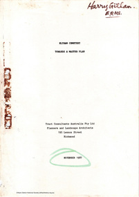
Document - Report, Tract Consultants Australia Pty Ltd, Eltham Cemetery: Towards a Master Plan, Nov 1987
BACKGROUND The Eltham Cemetery is of historic significance to the Eltham area. The Trust was established in 1858 and has administered and maintained the cemetery from that date right up to the present. Among the more noteworthy graves is that of Sir William Irvine, a former State Premier and Chief Justice of Victoria. Eltham Cemetery is surrounded on three sides by urban development. Montsalvat Artists Colony adjoins the remaining (eastern) side. A Joint Select Committee of Parliament called the “Mortuary Industry and Cemeteries Administration Committee" (MICA) enquired into the land requirements at the Eltham Cemetery in 1986. The MICA recommendations contained in its 1986 report are included in the Appendices attached to this report. Although the recommendations have not been adopted by the Government it is interesting to note that the MICA report recommended the use of the bulk of the land for cemetery purpose. In June of 1987, the Cemetery Trust was expanded to include additional members from the Eltham Community by the Minister for Health. At the same time, he instructed the Trust to resolve the land requirement issues. As a result of this Ministerial direction, Tract Consultants has been instructed by the Eltham Cemetery Trust to prepare a report addressing the issues raised in the Minister's letter (see Appendix 1) to the Trust. Principally, the study will examine options available for development of the Cemetery. These options will explore possible boundaries, cemetery design, vegetation, the overall environment, landscaping and financial planning for the Cemetery operations. Appendix 2 details the Cemetery Trusts Terms of Reference for the Study. Before commencing the study in detail, additional basic information was sought; viz: a) sub-soil and rock analysis; and b) feature survey by a Licensed Surveyor. The results from both exercises are included as appendices to this report. Section three includes a summary of the findings along with other analytical results. Also: Eltham Cemetery - planning bewteen 1859 to 1860; research by Alan Sheehan April 2015, collated by Harry Gilham, EDHS, April 2016 (2 pages) PROV Guide 5: Cemetery Records (8 pages), printed 7 May 2014Development of Eltham Cemeteryeltham cemetery trust, master plan, mica, montsalvat, mortuary industry and cemeteries administration committee, tract consultants -
 Eltham District Historical Society Inc
Photograph, Construction of new bridge over the Plenty River, Main Road, Lower Plenty, c.Aug. 1966
Construction of the Main Road bridge over the Plenty River. Includes structural members, construction personnel, vehicles and a Clarke mobile crane.Local significanceBlack and white printlower plenty, main road, plenty river, bridge, bridge construction, civil engineering, cranes, mobile cranes -
 Eltham District Historical Society Inc
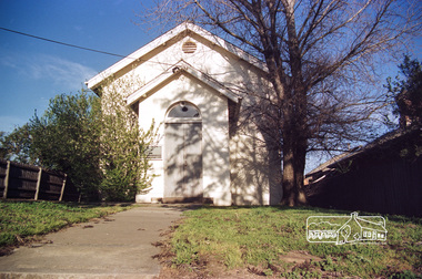
Slide - Photograph, Eltham Courthouse, 730 Main Road, Eltham, c.May 1988
Built in 1860, the Eltham Courthouse is the oldest public building remaining in Eltham. In its early days the building was used as the meeting place and office of the Eltham District Road Board and as an overflow classroom for the local school. The Eltham Courthouse ceased operational duties in 1984 and is now used by various community groups including Eltham District Historical Society. It was listed on the Victorian Heritage Register (Number H0784) in 1982. The building is of architectural significance because it retains intact early features. These include use of handmade bricks, simple decoration, roof trusses, timber ceiling boards, original windows, doors and associated hardware and a collection of court furniture. Additions to the court house have been done in a manner which did not interfere with the fabric of the original building. It is a fundamental asset in the Eltham Justice Precinct and is being fully restored in 2021 thanks to Nillumbik Shire Council.35mm colour positive transparency (1 of 23) Mount - Kodak EktachromeProcess Date MAY 88Meltham, eltham courthouse, main road -
 Eltham District Historical Society Inc
Document, Nillumbik Shire Heritage Study Stage Two, Significant Places, Graeme Butler & associates, 1997, 1997
Contents: Introduction Background Tage Two Team Significance Criteria Community Contacts Citation Structure List of Heritage Places Heritage Place Citations Appendices: Themes Criteria BibliographyProvide the foundation for future planning assessments in the shire106 A4 pages (single sided) pages (photocopied) no binding or covers. Appendices page 15 missing and Appendices page 16 a copy of a damaged pagenillumbik shire heritage study, graeme butler -
 Eltham District Historical Society Inc
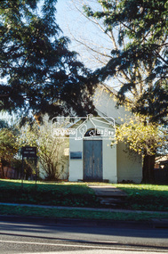
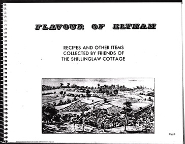
Booklet - Folder, Shillinglaw Cottage Preservation Committee, 2012
The Shillinglaw Cottage Preservation Committee, also known as The Shillinglaw Cottage Preservation Society, also known as the Friends of the Shillinglaw Cottage collated and published a community cookbook "Flavour of Eltham", first published in 1964 to raise funds for the preservation and re-location of this historical cottage in Eltham. This folders includes photocopies from the book, a letter requesting advertsing space and an article from The Australian Women's Weekly, December 23, 1964 (unable to locate via digitised AWW on Trove) Shillinglaw Cottage is of social significance as an important local landmark since the 1960s, once used as a handicraft and tourist centre, now a restaurant, and as an example of an early local community conservation project which led to the accurate reconstruction of the cottage close to its original site. - Victorian Heritage Database.6 photocopiesharry gilham collection, flavour of eltham, community cookbook, shillinglaw cottage preservation society, shillinglaw cottage preservation committee, friends of the shillinglaw cottage -
 Eltham District Historical Society Inc
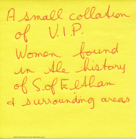
Booklet - Folder, Women of significance, 08/06/2004
Handwritten notes by H. G. listing names of women, with notes on family connections in some cases and brief list of their achievements including Nellie Ibbott, Charis Pelling, Beautrice Morrison, Ethel Osborne, Mavis Gill, Helen Knights/Harbeck, May Smart, Mrs A.M. Peake. Addressed to Journalist Helen Gillman and includes photocopy of article published about Charis Pelling (04966) Women as a group have frequently been excluded from official histories in the past. These research notes are an effort to compile a list of the contribution of local women, historically, to the development of the Shire of Eltham 2 pagesharry gilham collection, women, nellie ibbott, charis pelling, beautrice morrison, ethel osborne, mavis gill, helen knights, helen harbeck, may smart, a. m. peake -
 Eltham District Historical Society Inc
Document, Feedback to Nillumbik Shire Council by Eltham District Historical Society in response to September 2011 Draft Cultural Heritage Significance Assessment of the Eltham War Memorial Building Complex, 3 November 2011, 2011
... cultural heritage significance assessment, eltham district...Eltham District Historical Society Inc 728 Main Rd Eltham ...Report prepared for Nillumbik Shire Council by Samantha Westbrooke Pty Ltd in association with Peter Mills PhD, Architectural Historian5 A4 pages printed emailscultural heritage significance assessment, eltham district historical society, eltham war memorial, nillumbik shire council, peter mills, samantha westbrooke pty ltd -
 Eltham District Historical Society Inc
Audio Recording, Audio Recording; 2018-08-08 David and Jacqui Wagner and St Margaret's Church, Eltham, 8 Aug 2018
August Meeting (Newsletter No. 241, Aug. 2018) How do you consider designing an extension to a church that was built in 1861, just where do you start, especially when it is a church of local significance and listed by Heritage Victoria? The church in question was designed by architect Nathaniel Billings, built by well-known pioneer builder George Stebbing on land donated by Henry Dendy and is St Margaret’s Church in Pitt Street, Eltham. Adjoining this church is a large mud brick hall known to many of our Society members. It was also the venue for our 50th anniversary celebration dinner on 21st November 2017. At our Society meeting at 8.00pm on Wednesday 8th August 2018 architect David Wagner from Atelier Wagner will speak about the opportunities and challenges experienced in designing and constructing a contemporary style extension to this revered historical building, valued by the local congregation. Prior to becoming involved with St Margaret’s the Atelier Wagner architectural practice has, among an extensive range of projects, renovated and extended several churches. With this project there was also the challenge of incorporating, modifying and connecting the adjacent buildings that shared an entrance foyer.0:57:51 duration Digital MP3 File 20 MB audio recording, david wagner, eltham district historical society, jacqui wagner, meeting, society meeting, st margaret's church -
 Eltham District Historical Society Inc
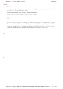
Document, War Memorial Building Complex, 903-907 Main Road, Eltham: Cultural Significance Assessment, November 2011, 2011
Prepared for Nillumbik Shire Council by Samantha Westbrooke Pty Ltd in association with Peter Mills PhD, Architectural Historian27 A4 pages plus two page summary of advice from Samantha Westbrooke regarding proposed landscaping around the cenotaph.cultural heritage significance assessment, eltham war memorial, peter mills, samantha westbrooke pty ltd, shire of nillumbik -
 Eltham District Historical Society Inc
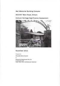
Document, Cultural Heritage Significance Assessment; Civic Building Complex, 903-907 Main Road, Eltham, September 2011 DRAFT, 2011
Prepared for Nillumbik Shire Council by Samantha Westbrooke Pty Ltd in association with Peter Mills PhD, Architectural Historian27 A4 pages color printcultural heritage significance assessment, eltham war memorial, peter mills, samantha westbrooke pty ltd, shire of nillumbik -
 Waverley RSL Sub Branch
Key
... Railway and the Sandakan airfield. this item is of historical ...During World War II, following the Fall of Singapore in February 1942, the Japanese military detained about 3,000 civilians in Changi Prison, which was built to house only 600 prisoners. The Japanese used the British Army's Selarang Barracks, near the prison, as a prisoner of war camp, holding some 50,000 Allied—predominantly British and Australian—soldiers.[1] Although POWs were rarely, if ever, held in the civilian prison, the name Changi became synonymous in the UK, Australia, and elsewhere with the POW camp. About 850 POWs died during their internment in Changi during the Japanese Occupation of Singapore,[2] a relatively low rate compared to the overall death rate of 27% for POWs in Japanese camps.[3] However, many more prisoners died after being transferred from Changi to various labour camps outside Singapore, including the Burma Railway and the Sandakan airfield.this item is of historical significance because it is supposedly one of the few surving keys to Changi Jail and donated by Mr.Robertson . Changi is significant as it was a major prison camp during WWII Changi Jail Key. Blackened metal key, Wooden tag attached with Japanese print on it. Kanji Characters read Middle Gatechangi, fall of singapore, key, p.o.w. -
 Ballarat Clarendon College
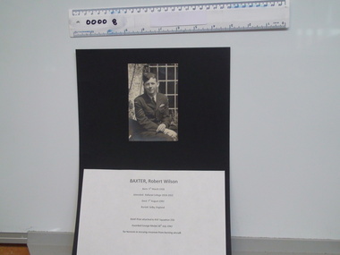
Robert Wilson Baxter (1935py) folder
... historical significance as they document the service and sacrifice ...This folder of text and photographic memorabilia relating to Robert Wilson Baxter (1935py) is a fascinating record of this former student's service and ultimate sacrifice for his country. Robert Baxter was awarded the George Medal on the 28th July 1942 for heroism in rescuing a fellow crewman from the burning wreck of their aircraft. The Medal was received by his family after Robert's death on 7th August 1942 as a result of an accident while taking off on operations. Robert Baxter's father, also Robert Wilson Baxter, was a Ballarat businessman who purchased the Ballarat Star Newspaper in 1897, selling it to the Courier in 1924. He was also part of Baxter and Stubbs Pty. Ltd. (Printers). Robert's mother attended Mrs Kennedy's School for Girls. Items in the folder have historical significance as they document the service and sacrifice of a RAAF sergeant during World War Two. Archival folder relating to Robert Wilson Baxter (05/03/1918 - 07/08/1942), including photographs of RWB in squadron uniform and receiving wings, visit of Robert Menzies to Squadron, gravestone at Selby, England; telegrams to parents re war injury and discharge from hospital; letters, newspaper clippings and extract from the London Gazette relating to his posthumous receipt of the George Medal; letters of condolence from his Wing Commander and His Majesty George VI; Obituaries and in memoriams; letter from his sister, Margaret Jamieson, re donation of items to BCC. raaf, royal australian air force, george medal, second world war, robert wilson baxter, world war two honour roll, margaret jamieson, robert menzies, 1935py -
 Ballarat Clarendon College
Medal, The 1914-15 Star, 12/1918
... archives. They have historical and social significance ...The 1914–15 Star was authorised in 1918 and was awarded for service in specified theatres of war between 5 August 1914 and 31 December 1915. A recipient of the 1914 Star could not also be awarded the 1914–15 Star. The medal is accompanied by its original box. The Holgate medals were the first war medals held by BCC archives. They have historical and social significance for the College.The 1914-15 Star is a four pointed star of bright bronze, ensigned with a crown. The obverse has crossed gladius, overlaid with an oak wreath that is ensigned with the cypher of King George V. A scroll bearing the legend 1914-15 is centrally placed across the crossed blades. The 1914-15 Star ribbon has the red white and blue colours of the Empire, in shaded and watered stripes. The medal is accompanied by its original box.Engraved on a scroll in the centre of the medal front: '1914-15' The oak wreath is ensigned with the cypher of King George V. The back of the medal is engraved: '3193 / Pte E. S. HOLGATE / 6/F AMB. A.I.F. The box lid is inscribed: 'AMC/13 / 3193 / Pte. E. S. Holgate / 6/F.Amb,A.I.F. / 9350/Decd.'world war one, medal, 1914, the 1914 15 star, w w 1, private e s holgate, holgate, a i f, australian imperial force, holgate medal -
Ballarat Clarendon College
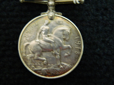
Medal, Victory Medal 1914-19, 01/09/1919
... archives. They have historical and social significance ...The Victory Medal (also called the Allied Victory Medal) is a campaign medal - of which the basic design and ribbon was adopted by Belgium, Brazil, Cuba, Czechoslovakia, France, Greece, Italy, Japan, Portugal, Romania, Siam, Union of South Africa and the USA. The medal was issued to all those who received the 1914 Star or the 1914-15 Star, and to most of those who were awarded the British War Medal - it was never awarded singly. These three medals were sometimes irreverently referred to as Pip, Squeak and Wilfred.The Holgate medals were the first war medals held by BCC archives. They have historical and social significance for the College.The Victory Medal is a 36mm diameter circular copper medal, lacquered in bronze. The obverse shows the winged, full-length, full-front, figure of Victory, with her left arm extended and holding a palm branch in her right hand. The reverse has the words ‘THE GREAT / WAR FOR / CIVILISATION / 1914-1919' in four lines, all surrounded by a laurel wreath. The 39mm wide ribbon has a ‘two rainbow' design, with the violet from each rainbow on the outside edges moving through to a central red stripe where both rainbows meet.The reverse has the words ‘THE GREAT / WAR FOR / CIVILISATION / 1914-1919' in four linesworld war one, ballarat college, victory medal, w w 1, e s holgate, allied victory medal -
 Ballarat Clarendon College
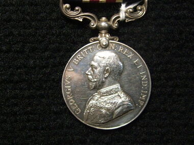
Medal, British War Medal, 1918
... war medals held by BCC archives. They have historical ...The British War Medal 1914-20 was iInstituted by King George V in 1919 to mark the end of World War I and record the service given. The qualification period was later extended to cover post-war mine clearance and service in Russia during 1919 and 1920. The British War Medal was awarded for service in a theatre of war between 5 August 1914 and 11 November 1918. Those eligible included members of women's organisations; persons on the staffs of military hospitals and members of recognised organisations who handled sick and wounded; and members of other duly recognised or other authorised organisations as specified in medal regulations. The qualification period was later extended to cover post-war mine clearance and service in Russia during 1919 and 1920. Lieut E. S. Holgate was mentioned in despatches for Gallantry in the Field 24/25 April 1918. He was killed in action at Villers-Bretonneux, 27 April, 1918. The British War Medal completes a trio of medals awarded to Lieut. E. S. Holgate, including the 1914-15 Star and the Victory Medal. The Holgate medals were the first war medals held by BCC archives. They have historical and social significance for the College.The British War Medal is round and made of cupro-nickel. It features the effigy of George V on the obverse. The reverse has an image of St George on horseback trampling underfoot the eagle shield of the Central Powers, and a skull and cross-bones, the emblems of death. Above this is the risen sun of victory. The British War Medal has a wide central watered stripe of orange, flanked by two narrow white stripes, which are in turn flanked by two black pin-stripes, further flanked by two outer stripes of purple. The colours have no particular significance. Impressed around edge are the recipient's details. Inscribed around outer edge of obverse: 'GEORGEIVS V BRITT. OMN:REX ET IND:IMP:' Impressed around edge of medal: 'LIEUT.E.S.HOLGATE. A.I.F.' Inscribed on the reverse '1914 1918'medal, 1918, world war 1, british war medal, w w 1, holgate, a i f, australian imperial force, holgate e s, holgate medal -
 Ballarat Clarendon College
Medal, Military Medal GV, Instituted 25th March 1916
... at Zonnebeke 11 October 1917. Historical and social significance ...Instituted in 1914, the Military Cross (MC) was issued for gallantry in presence of the enemy to warrant and junior officers of the Army who were ineligible (on account of their rank) for the Distinguished Service Order. During the First World War, it was also available to equivalent ranks in the Royal Naval Division and Royal Marines and it later became available to equivalent ranks in the RAF for acts of gallantry on land. The equivalent award for the other ranks for gallantry on land in presence of the enemy was the Military Medal (MM) which had been instituted in 1916 and, similarly to the MC, later became available to RAF other ranks serving on the ground. This medal was awared to Pte H. S Holgate for bravery in the field in 1917. Pte Holgate was killed in action at Zonnebeke 11 October 1917. Historical and social significance for schoolSilver medal with a swivelling suspension. features King George the V, uncrowned, in Field Marshal's uniform on the obverse. The medal reverse depicts the crowned royal cypher over the words "FOR BRAVERY IN THE FIELD" all within a laurel wreath. Impressed around edge are the recipient's details. The ribbon has a central stripe of thin red and white lines flanked by equally sized stripes of navy. Inscribed around obverse: 'GEORGIVS V BRITT: O[M]N: REX ET IND: IMP:' Inscribed in centre of reverse below royal insignia : 'FOR/BRAVERY/IN THE/FIELD' Impressed around OUTER edge of medal: '4303 PTE H. S. HOLGATE. 8/COY AUST. M.G.C.' Notation on original box A./Cpl H.S.Holgate 29Bn AIF 51531/Decd. 43031917, medals, military medal, world war i, w w 1, holgate, private h s holgate, zonnebeke, holgate medal