Showing 1969 items matching "tourists"
-
 Ballarat Tramway Museum
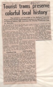
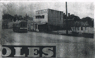
Newspaper, Tourist Trams preserve colourful local history - Ballarat - 1975
.1 - Newspaper clipping from The Sun or The Courier (all ?) 10/12/1974 and 3/2/1975, reporting on the planned and then the reopening of the BTPS. Not sure which newspaper and actual date. Has one photograph of No. 26 outside the depot. .2 - Newspaper from The Courier, titled "Just like the old days", Monday Feb. 3, 1975, following the formal re-opening for the BTPS. Has four trams in the photo with Bill Stephen MLA and Dudley Erwin MP standing alongside. Tram 27 is leading. .3 - Second copy of "Tourist Trams preserve colourful local history", adherred to a single sheet of faintly lined foolscap paper, dated 3/2/1975 Has a strong association with a Melbourne tram driver who assembled the scrap book and series of photos of Ballarat trams at the time of closure and the re-opening of the tram museum by the Ballarat Tramway Preservation SocietySet of newspaper cuttings contained with Reg item 5988, a Stamford Kiwi School Scrap Book - card covers, 23 sheets, spiral bound, titled "Ballarat", prepared by Ellen Butland of Auckland following the closure of the SEC Ballarat Tramway system.trams, tramways, ballarat, btps, opening, tram 26, tram 27, btps depot -
 Parks Victoria - Mount Buffalo Chalet
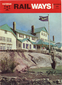
Magazine, "Victorian Railways November 1974"
'Over the years the VR Advertising Division published a number of booklets promoting Mount Buffalo's sports and restorative powers of its scenery in summer and winter...The collection (MBCC) comprises a good range of tourist writing published as promotional booklets, guidebooks, brochures, walking trails, maps and newspaper articles.' (Pg. 119. Historica) This Victorian Railways monthly publication and also the VR Newsletter, published by the Victorian Railways Printing Works in North Melbourne, is one of a number which featured iconic photos of the Chalet of the plateau on its cover, as an identifiable flagship for The Victorian Railways and it's employees from the Railways Refreshment and Services Branch. These publications also have stories regarding upgrades and on long serving staff of the Chalet.Listed in Draft Inventory of Significant Collection Items . Appendix A.3. Promotional material.. (Pg 168. Historica).Railways magazine featuring an image of the chalet on the front cover and an article about the Chalet.Yes -
 Parks Victoria - Mount Buffalo Chalet
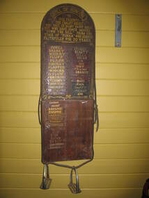
Honour Board
Was located in the stables at Mount Buffalo Chalet. It was used to record the names of horses that were ridden by Chalet guests when they were holidaying at the Chalet. 'Admiring the rugged beauty of the Buffalo Plateau and exploring its scenic attractions ...quickly became part of the Mount Buffalo Chalet tourist experience...The Chalet facilitated the experience by hosting guided tours, including trail rides on horseback...the horses remained at the Chalet for decades, and have been remembered with great affection, as demonstrated by the honour roll for Chalet horses and various commemorative plaques.' (Pg 98. Historica) Many of these horses are still remmbered by former guest of the Chalet. Granite and Punka were legendary and plaques in their honor are mounted on the large granite boulders in the stableyards.Listed in Draft Inventory of Significant Collection items. Appendix A.3, Snow sports equipment and other recreational items. (Pg 166 Historica).Wooden plaque with names painted onto strips of leather fixed to a board. The board is made of two sections of wood and is arched at the top and squared at the base. The piece at the top that appears to be earlier and has gold painted inscriptions with decorative scrolling around the edge. The board has leather strapping around the edge and two stirrups threaded onto leather at the base. The upper section of the board has all the names painted onto leather strips. The lower section of the board has some names painted onto strips but also some names are scratched directly onto the wood.At top of plaque, "ROLL OF HONOUR /TO / OUR FRIENDS - / THE CHALET HORSES, / WHO GAVE US MANY HAPPY HOURS / BUT WHO HAVE SINCE MOVED / "DOWN THE HILL". FROM THE / TIME OF "PUNKA" / WHO SERVED / FAITHFULLY FOR 20 YEARS" Underneat this are the names of the individual horses starting with , "PUNKA....." -
 Ballarat Tramway Museum
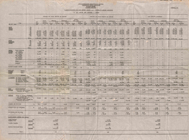
Administrative record - Ballarat, State Electricity Commission of Victoria (SECV), "Traffic Statistics for four months period", 2/1952
Set of four typed documents dated 23/2/1952: Appendix A - All routes and Sections - Adults Appendix B - City to Sebastopol and other routes Appendix C - One section on all routes and city sections Appendix D - Summary of comparisons with average for previous two years. Sets out tables for 1947/48, 1949/50 and 1951/52. Gives information on tickets and transfers issued, weekly tickets, tourist tickets issue, scholar's tickets issued, passengers, tram mileages, revenue, revenue per car miles, average fare per passengers, passengers per car miles, and misc. revenues - papers, parcel tickets and special chartered trams.Yields information about the type of traffic reports prepared by the SECV Ballarat to provide detail of passengers carried, tramcar mileages, and statistics.Set of four large format sheets, heavily creased, typed originals.tramways, ballarat, reports, traffic, weekly tickets, transfer tickets, secv, revenue, statistics -
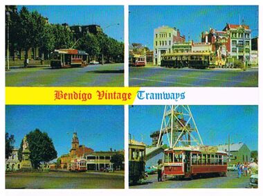 Bendigo Historical Society Inc.
Postcard - BENDIGO TRAMS - BENDIGO VINTAGE TRAMWAYS
coloured postcard. 4 separate images showing views of trams in Bendigo streets, Pall Mall, Charing Cross, Alexandra Fountain, Deborah Mine. On back of card 'Post Card, The Rose Series Deluxe. No. 19, in front of Post Office and Civic Buildings, Built Duncan & Fraser, Adelaide, 1920, came to Bendigo 1935. No. 5 at Alexandra Fountain - built 1913 Adelaide. No. 25 at the Gold Monument, one of the first trams to start the Bendigo Tourist Tram Service. No. 30 at the Central Deborah Mine, this Birney is probably the oldest of its type to come to Australia. Built USA.' ' The Bendigo Trust, PO, Box 333, Bendigo, Australia, 3550'Rose Seriesbendigo, tramways, trams in street views, bendigo, alexandra fountain, charing cross, central deborah, post office, duncan and fraser, birney, tourism -
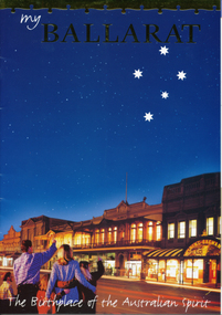 Ballarat Tramway Museum
Pamphlet, Ballarat Tourism, "My Ballarat, the Birthplace of the Australian Spirit", Nov/Dec. 1998
48 page, colour printed on glossy paper, Ballarat Tourism brochure designed for interstate and overseas tourist to make Ballarat, their destination. P13 associated with Steve Moneghetti's story of 'my Ballarat', including a photograph of tram 26, at Gardens Loop during a Begonia festival. Conductor in rear compartment of 26. Telephone box open, obscuring a BTM member standing by phone in uniform. P45 has City of Ballarat map, showing tramway and museum/depot. Track does not project beyond depot spur to Carlton St. Brochure features stories from Ballarat residents and visitors, including other district items, features and accommodation section.trams, tramways, ballarat tourism, city of ballarat, btm -
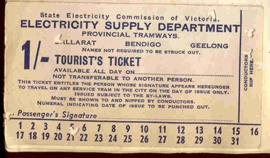 Ballarat Tramway Museum
Ephemera - Ticket, State Electricity Commission of Victoria (SECV), "Tourist Ticket SEC 1/", 1937
Ticket contained within Reg. Item 2526, page 58, SECV - Ballarat Tourist Ticket - 1/- on light weight card, white colour - punched for October 5, 1939, for use in Ballarat. Has three conductor's punches in the right hand margin of the ticket. Has numbers "1" to "31" on bottom section of the ticket. On rear has year and month of use. Has been glued in to the sheet in the bottom left hand corner - hiding the SEC form number. Item not formally numbered. Image btm2541i shows position on page relative to items 2541 to 2545. Handwritten notes, Reg. Item 2541, make reference to these items.trams, tramways, tourist tickets, tickets, sec -
 Bendigo Historical Society Inc.
Document - VICTORIA HILL - VISITOR PLANS FOR VICTORIA HILL
Handwritten carbon copy and typed copy of notes on 1st and 2nd stage plans for a tourist area on approx. 20 acres at Victoria Hill. First stage was to clean up the area, locate and sign post shafts, engine beds, etc and prepare a topographical map with these features on it. Second stage was to arrange for the purchase of typical miners homes and shops in the vicinity to be restored for inspection by visitors. Mining equipment to be placed in the area. Prepare brochures for sale. Set up a mining museum.Prepare an area near BCV 8 with direction finder to mining and general features, as this has the best natural ground level view in the City. Notes prepared by Albert Richardson.mine, gold, victoria hill, victoria hill, visitor plans for victoria hill, darrel mcclure, bendigo city council, bendigo historical society, central nell gwynne, caleb thomas, bcv 8, lazarus, old chum, new chum, victoria, repeater station (p. m. g.) -
 Bendigo Historical Society Inc.
Newspaper - LONG GULLY HISTORY GROUP COLLECTION: EAGLEHAWK ROAD
BHS CollectionPhotocopy of a newspaper article and photo of Eaglehawk Road with a tram outside a two story newsagency. On the right is a dilapidated timber fence. Written on the back is: approx 1966 ? One of the last trams No. 18 to run up Main Street of Long Gully (Bond Street) now known Eaglehawk Road. On Left Post Office - now Gents Hairdresser & Rose of No. 3 Australia Hotel. On right Les & Marie Norris Newsagency & Mixed Business. 2 story Building was Commercial Hotel. No. 26 Tram was the last To Run between Bendigo , Long Gully & Eaglehawk still running as a Tourist tram in Bendigo 1987. Donated by Alan Crossley 1985.bendigo, history, long gully history group, the long gully history group - eaglehawk road, mr l w norris, country roads board, mr g marshallsea, rose of australia hotel, les & marie norris, commercial hotel, alan crossley -
 Bendigo Historical Society Inc.
Postcard - Postcards x 12
Colored postcards of Bendigo x 12 - Chinese Gardens, part of the Golden Dragon museum complex; Tourist Information Centre and Law Courts, formerly the old Post Office built 1887; Sunrise over Rosalind Park and the city of Bendigo; City Town Hall, begun in 1859; historic kilns at Bendigo Pottery; Water Pavilion, part of the Chinese Gardens section of the Golden Dragon Museum; Shamrock Hotel, built in 1897; shores of Lake Eppalock; view of View Street; glasshouse conservatory, part of Rosalind Park, Pall Mall; iron-work entrance to Rosalind Park conservatory; and interior of Sacred Heart Roman Catholic Cathedral of 1897.bendigo, gardens, chinese, pottery -
 Ballarat Heritage Services
Digital Photograph, Ashbourne, UK
Ashbourne was the village of an historical event. At Ashbourne on 3 December 1745 Charles Edward Stuart declared his father James King of England, Wales and Scotland. Ashbourne is one of Derbyshire's fines and most vibrant market towns. It combines a wealth of historic buildings and shops. The Market Place is cobbles with hidden alleys and yards that lead to the carparks behind the main street. The wide and elegant Church Street is considered to be the finest street of Georgian buildings in Derbyshire. Tissington Hall and Village are in the nearby vicinity. Built by Francis Fitzherbert in 1609 Tissington Hall has been lived in by the Fitzherbert family ever since. The estate village has a number of micro businesses and a beautiful duck pond. Reference: Information from the Ashbourne Tourist pamphlet -
 Melbourne Tram Museum
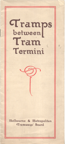
Booklet, Melbourne & Metropolitan Tramways Board (MMTB), "Tramps between tram termini", c1930
Booklet - promoting tram travel and walking trips or "tramps" between various tram terminus. Includes notes on the Board's services, its tourist tram with notes and fares on specific walks. Includes a map and some photos for each walk. 1 - Brighton Road to Hawthorn 2 - Burwood to Mont Albert 3 - Carnegie to Darling Road 4 - Whitehorse Road to East Kew 5 - Glen Iris to Darling Road 6 - Maribyrnong River to Mt Alexander Road 7 - Gardiner or Glen Iris to Burwood 8 - Wallen Road Bridge to Glenferrie Road 9 - Johnston St Bridge to Victoria Bridge At the time, some of these walks would have been through largely undeveloped land and parks.Demonstrates a promotion of the MMTB tram services and leisure activities.Booklet - 16 pages, two colours on light fawn paper, centre stapled.tramways, showgrounds, william st, mmtb -
 Sunbury Family History and Heritage Society Inc.
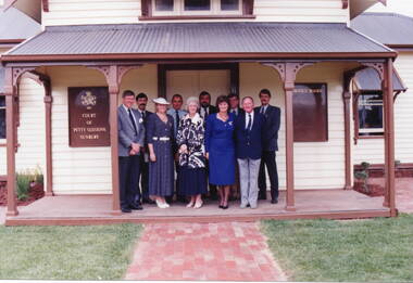
Photograph, Sunbury Courthouse, 1993
The group in the photograph at the opening of the former Sunbury Courthouse. The Courthouse was built in 1885 and functioned in that capacity until 1989 when it closed. In the 1992, Shire of Bulla council began to restore the building, which was completed in 1993. It functioned as a Tourist Information Centre until 2019, when that service was transferred into the new Global Learning Centre in Sunbury. The building is now occupied by the local Sunbury Aboriginal Corporation. Invited guests at the opening of the restoration in 1993 were from L- R: Back- Phil McMahon, Mayor, Sgt. Doug. McArthur, Sunbury police, John Munns, John Barnier, Jeff Cossum, Museum curator. L-R: Front - Peter Free, Cr. Kathy Duncan, Joy Munns and Cr. Veronica Burgess.The former Sunbury Courthouse was an important official building serving Sunbury and the surrounding area for over half a century. A non-digital coloured photograph of nine people at an official function are standing on the verandah of a weatherboard building. There is a timber notice board attached to the wall on either side of the group. phil mcmahon, doug. mcarthur, john munns, john barnier, jeff cossum, peter free, kathy duncan, joy munns, veronica burgess, sunbury courthouse, sunbury -
 The Beechworth Burke Museum
Photograph, 1960s
This photograph was taken in the 1960s at Lake Sambell and is a view across the lake from the east side, the photo was taken during a period of improvements to the lake and surrounding area. Lake Sambell is an artificial lake that was created on the site of the old Rocky Mountain Mining Company workings and was officially opened by Minister for Lands, Mr Baily, on October 5, 1928. The disused and unattractive remains of the mine were converted into a recreational area intended for swimming, boating, and fishing. The lake is named after Mr L.H. Sambell, shire engineer and secretary of the Forward Beechworth Committee, who advocated for the enhancement of Beechworth into a tourist destination and was central to the planning and establishment of the lake. Funding for the project was raised through both competition funds and donations. Since the construction in 1928 several engineering issues have arisen. In 1939 the water levels were low, and the lake was considered both an eyesore and ‘mudhole’, Beechworth Shire Council sort funding to raise the height of the lake six feet to improve the quality of water. Throughout the 1940s the Beechworth Swimming Club sort to address the structural engineering issues and improve swimming facilities at the lake. R.E. Carter, similar to L.H. Sambell, was a shire engineer who advocated the importance of positioning Beechworth as a tourist destination. Carter held the position of shire engineer from 1954-63 and organised many improvements to the Lake Sambell area including the caravan park in 1959, the lake swimming pool in 1961, water skiing and boating facilities, and increased the lake surface area in 1964. These improvements to the lake also reflect an increase in leisure time and access to travel during a period of post-war prosperity in Australia during the 1950s and 60s. This photograph is of historical significance as it documents Lake Sambell in the 1960s after a series of enhancements to the lake area to improve its appearance and usability for both the people of Beechworth and tourists. It is also of social significance in providing an insight into the increase in leisure time and access to travel during a period of post-war prosperity. Black and white rectangle photograph printed on photographic paper and unmounted.Reverse: 3534 C798lake sambell, l.h. sambell, r.e. carter, rocky mountain mining company, forward beechworth committee, beechworth swimming club, wallace park lake sambell development scheme, lake sambell caravan park, beechworth 1960s, lake sambell swimming pool, lake sambell boating, lake sambell fishing, swimming, boating, water skiing, fishing, post-war prosperity, minister of lands, artificial lake, open cut sluice mine, lake -
 The Beechworth Burke Museum
Photograph, 1960s
This photograph was taken in the 1960s at Lake Sambell Caravan Park and visible in the photograph are individual caravan sites with electricity outlets, a large single-story building with a caravan park banner, dirt roads, a freestanding message board, and a parked car. Lake Sambell Caravan Park opened in 1959 owing to the work of R.E. Carter, Beechworth Shire engineer from 1954-63. Carter advocated for improvements to the lake and surrounding area in order to encourage tourism in Beechworth. The opening of the caravan park was part of many improvements to Lake Sambell made in this period by Carter including: the swimming pool in 1961, water skiing and boating facilities, and increased lake surface in 1964. These improvements were financed mainly by grants from the Tourist Development Authority. The popularity of caravanning in Australia exploded during this post-war period of the late 1950s and 1960s. This popularity was driven by multiple factors, including: the stopping of fuel rations, the accessibility of car ownership through the manufacturing of affordable cars, technological developments in caravan design, and the increase in prosperity and leisure time for many Australians. Facilities such as electrical outlets to power caravans are present in this photograph of Lake Sambell Caravan Park. Lake Sambell is an artificial lake that was developed on the previous site of the Rocky Mountain Mining Company workings and was officially opened by Minister for Lands, Mr Baily, on October 5, 1928. The disused and unattractive remains of the mine were converted into a recreational area intended for swimming, boating, and fishing. The lake is named after Mr L.H. Sambell, shire engineer and secretary of the Forward Beechworth Committee, who advocated for the enhancement of Beechworth into a tourist destination and was central to the planning and establishment of the lake. This photograph is of historical and social significance in providing insight into caravanning during the 1960s in Australia. Caravanning was extremely popular during the 1960s in Australia due to multiple social and economic factors including the stopping of fuel rations, the accessibility of car ownership through the manufacturing of affordable cars, technological developments in caravan design, and the increase in prosperity and leisure time for many Australians.Black and white rectangle photograph printed on photographic paper and unmounted.Reverse: 3536/ [logo back printing: KODAK/ VELOX/ PAPER] / C798 lake sambell caravan park, lake sambell, caravanning 1960s, caravan park, rocky mountain mining company, kodak velox paper, r.e. carter, l.h. sambell, caravan electricity outlets, tourist development authority, post-war prosperity, forward beechworth committee, lake sambell boating, lake sambell swimming pool, lake sambell fishing, artificial lake, travel 1960s, recreation 1960s -
 The Beechworth Burke Museum
Photograph, 1960s
This photograph was taken in the 1960s at Lake Sambell Caravan Park, visible in the photograph are individual caravan sites with electricity outlets, a large single-story building, a parked car, and two caravans partially obstructed by trees. Lake Sambell Caravan Park opened in 1959 owing to the work of R.E. Carter, Beechworth Shire engineer from 1954-63. Carter advocated for improvements to the lake and surrounding area in order to encourage tourism in Beechworth. The opening of the caravan park was part of many improvements to Lake Sambell made in this period by Carter including: the swimming pool in 1961, water skiing and boating facilities, and increased lake surface in 1964. These improvements were financed mainly by grants from the Tourist Development Authority. The popularity of caravanning in Australia exploded during this post-war period of the late 1950s and 1960s. This popularity was driven by multiple factors, including: the stopping of fuel rations, the accessibility of car ownership through the manufacturing of affordable cars, technological developments in caravan design, and the increase in prosperity and leisure time for many Australians. Facilities such as electrical outlets to power caravans are present in this photograph of Lake Sambell Caravan Park. Lake Sambell is an artificial lake that was developed on the previous site of the Rocky Mountain Mining Company workings and was officially opened by Minister for Lands, Mr Baily, on October 5, 1928. The disused and unattractive remains of the mine were converted into a recreational area intended for swimming, boating, and fishing. The lake is named after Mr L.H. Sambell, shire engineer and secretary of the Forward Beechworth Committee, who advocated for the enhancement of Beechworth into a tourist destination and was central to the planning and establishment of the lake. This photograph is of historic and social significance in documenting the enhancement of the Lake Sambell area overseen by R.E. Carter and providing insight into caravanning during the 1960s in Australia. Caravanning was extremely popular in Australia during the late 1950s and 60s due to multiple social and economic factors including the stopping of fuel rations, the accessibility of car ownership through the manufacturing of affordable cars, technological developments in caravan design, and the increase in prosperity and leisure time for many Australians. Black and white rectangle photograph printed on photographic paper and unmounted.Reverse: 3538/ [logo back printing KODAK/ VELOX/ PAPER] / C798lake sambell caravan park, lake sambell, lake sambell 1960s, lake sambell fishing, lake sambell boating, lake sambell swimming pool, r.e. carter, l.h. sambell, tourist development authority, caravanning 1960s, caravan electricity outlets, caravan park, forward beechworth committee, rocky mountain mining company, lake caravan park, caravan mid 20th century, beechworth tourism, travel in the 1960s, holiday 1960s -
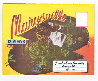 Marysville & District Historical Society
Postcard (item) - Colour photographs, Murray Views, Marysville 12 Views, 1950's
A fold out postcard of 12 colour photographs of scenes and landscapes in and around Marysville in Victoria.A fold out postcard 12 colour photographs of scenes and landscapes in and around Marysville in Victoria. These photographs were produced by Murray Views in Gympie, Queensland as a souvenir of Marysville.Marysville/ 12 VIEWS from Mrs Mary Keneally/ Marysville/ 28.11.91 PRODUCED BY MURRAY VIEWS./ GYMPIE./ Q COPYRIGHT SAMUEL LEE & CO., PRINTERS. STEAVENSON'S FALLS, MARYSVILLE, VIC. TOURISTS AT MARYSVILLE, VIC. "FRUIT SALAD FARM", MARYSVILLE MAIN STREET, MARYSVILLE, VIC. ROAD SCENE, MARYSVILLE, VIC. THE CROSSWAYS, MARYSVILLE, VIC ROAD TO CUMBERLAND VALLEY, MARYSVILLE PANORAMA FROM BLACK SPUR, MARYSVILLE ROAD, MARYSVILLE, VIC. NICHOLL'S LOOKOUT, MARYSVILLE, VIC. TREE FERNS, MARYSVILLE, VIC. THE BRIDGE, MARYSVILLE, VIC.steavenson falls (image 1), tourists in marysville (image 2), taggerty river (image 3), fruit salad farm (image 4), main street marysville (image 5), road scene marysville (image 6), the crossways (image 7), cumberland valley (image 8), black spur (image 9), nicholl's lookout (image 10), tree ferns (image 11), bridge (image 12), marysville, victoria, postcard, souvenir, murray views -
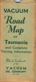 Bendigo Historical Society Inc.
Document - BILL ASHMAN COLLECTION: VACUUM MAP OF TASMANIA
Vacuum Road Map of Tasmania and Complete Touring Information with the Compliments of the Vacuum Oil Company Pty Ltd. Coloured map of Tasmania with trucks, aeroplane, oil bottles and petrol bowsers in the margins. Alphabetical Index of Towns, Lakes, Mountains, Bays, Capes, etc., with key and Licensed Public Aerodromes in Tasmania and Their Location. On the back is Outlets of Hobart, Outlets of Launceston, What to See in Hobart, Beauty Spots and Tourist Information, What to See in Launceston, Vacuum Products, Traffic Hints, Super Plume or Plume, Making Sure of a Trouble-Free Trip and the front cover picture of a lady, child and a man in their car at the petrol bowser. Map folds up and is kept in a light green folder.map, bill ashman collection - correspondence, vacuum road map of tasmania and complete touring information, vacuum oil company pty ltd -
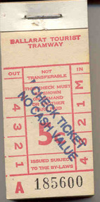 Ballarat Tramway Museum
Ephemera - Ticket/s, Ballarat Tramway Museum (BTM), BTPS 5d - over stamped No value, 1974
Demonstrates the Museum's ticketing systems and ongoing production of tickets.Block of 200 tickets - light red ink on off white paper, original denomination 5c, lettered A 185600 to A 185799, headed Ballarat Tourist Tramway and over stamped "CHECK TICKETS NO CASH VALUE". The 200 tickets have been stapled onto a heavy cardboard back with a heavy metal staple. See also Reg. Item 2306 for over stamped 5c tickets using a different stamp. The tickets are in the style of the former State Electricity Commission of Victoria tramway tickets. Tickets originally printed for general use on the trams 1974. Later over stamped for use on trams as check tickets for passengers travelling on special trams etc. See Fare structure of BTM/BTPStrams, tramways, btm, tickets -
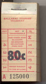 Ballarat Tramway Museum
Ephemera - Ticket/s, Ballarat Tramway Museum (BTM), BTPS 5c over stamped 80c, 1974
Demonstrates the Museum's ticketing systems and ongoing production of tickets.Block of 200 tickets - light red ink on off white paper, original denomination 5c, lettered A 125000 to A 125199, headed Ballarat Tourist Tramway and over stamped "80c" in black ink. The 200 tickets have been stapled onto a heavy cardboard back with a heavy metal staple. The tickets are in the style of the former State Electricity Commission of Victoria tramway tickets. Tickets originally printed for general use on the trams 1974. Later over stamped to act as 80c tickets to save printing new tickets. Tickets used as Adults and Children (return). See btm Fare Schedule.doc Collected a the time of first issue - 26/10/1985 Fare structure of BTM/BTPStrams, tramways, btm, tickets -
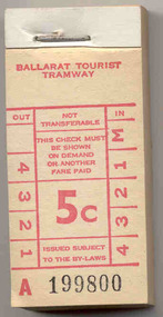 Ballarat Tramway Museum
Ephemera - Ticket/s, Ballarat Tramway Museum (BTM), BTPS - 5c, Oct. 1975
Demonstrates the Museum's ticketing systems and ongoing production of tickets.Block of 200 tickets - red ink on off white paper, denomination 5c, lettered A 199800 to A 199999, headed Ballarat Tourist Tramway. The 200 tickets have been stapled onto a heavy cardboard back with a heavy metal staple. The tickets are in the style of the former State Electricity Commission of Victoria tramway tickets. Tickets in use as Museum entry tickets from mid 1972 at the depot, then as child single tickets in 1974 to 1975. See BTM Fare Chart. Also used as tickets for other purposes such as check tickets and 50c tickets over stamped, cash received checks as donations for many years. Printed 1971? See Fare structure of BTM/BTPStrams, tramways, btm, tickets -
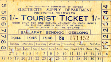 Ballarat Tramway Museum
Ephemera - Ticket/s, State Electricity Commission of Victoria (SECV), Tourist Ticket SEC 1/, c1944
SECV - Ballarat Tourist Ticket - 1/- on light card, light manilla colour - purchased for Ballarat, Jan 24, Friday - year not punched. Both punch marks 1 & 3, nipped as well. Ticket No. Ba171452. In 1944,45 or 46 Friday 24 Jan did not occur - see attached calendar sheet - a perpetual calendar of the Internet 1/97 but would have occurred during 1947. Possibly left over stock from previous three years being finished off? Front of ticket see btm499i1.jpg Rear of ticket see btm499i2.jpg See also Reg Item 2108 and 4129 for other examples of the ticket overprinted for 1947 to 1949.trams, tramways, sec, ballarat, tourist ticket -
 Ballarat Tramway Museum
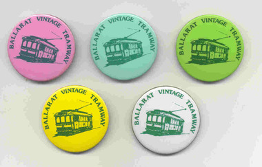
Badge - BTPS Button, Patrick Bros Melbourne, 2000?
Set of five button badges produced by the Ballarat Tramway Museum for sale. Badges made with various coloured images of tram 31, with the words "Ballarat Vintage Tramway" around the edge of the badge and then pressed onto a metal back with a pin. Made by Patrick with their name and phone number stamped in to the centre of the rear of the badge. Have been made in a similar fashion since the mid 1970's for the BTPS/BTM. .1 - light green back .2 - white back .3 - pink back .4 - light blue back .5 - yellow back with a larger pin on rear and Patrick name not stamped into the centre. See Reg Item 6381 for a "Ballarat Tourist Tramway" example.tramways, trams, btm, sales, badges, ballarat vintage tramway -
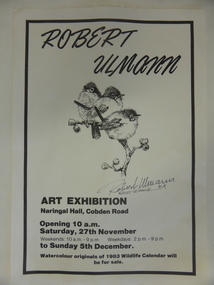 Warrnambool and District Historical Society Inc.
Poster, Poster for Robert Ulman exhibition, 1982
This is a poster advertising an art exhibition by the Warrnambool artist, Robert Ulmann. The exhibition was held in the Naringal Hall in November/December 1982. Robert Ulmann (1927-1999) was born in Zurich, Switzerland where he studied sculpture and painting. After living in Canada for some time he came to Australia in 1969. From 1970 to 1972 he was employed by the Northern Territory Administration as a manual arts instructor to the aboriginal people of Docker River west of Uluru. He exhibited extensively in city and regional galleries and won numerous awards for his artistic works. His love of wildlife extended to his interest in the Southern Right Whale and he was greatly responsible for publicizing the annual appearance of the whales at Logans Beach in Warrnambool and protecting their environment. His studio in Warrnambool is still visited by many tourists. This poster is of interest as it concerns an art exhibition of the work of Robert Ulmann, a well-known Warrnambool artist of the 20th century. This is a sheet of white paper with black edging. It is an advertisement for a Robert Ulmann Art Exhibition. The page has a sketch of three birds with Robert Ulmann’s signature underneath. robert ulmann, history of warrnambool -
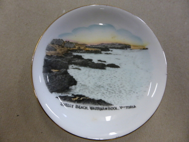 Warrnambool and District Historical Society Inc.
China, Saucer, Mid 20th century
This is a dish or pin tray sold in Warrnambool as a souvenir of the city. It features Shelly Beach, one of the popular picnic spots, especially in the first half of the 20th century. This dish was made by Royal Stafford China and was presumably produced with a plain centre so that an illustration of a tourist spot in Australia could be reproduced on the dish. There were many similar items produced by Royal Stafford China that featured Warrnambool scenes and were selling in Warrnambool in the 1930s, 40s and 50s. They were all good quality items and so many have survived today. They were useful as well as decorative – vases, plates, cups and saucers etc. Some business houses in Warrnambool also had Royal Stafford China souvenir items featuring the business name to sell or give away to customers. Tourism in Warrnambool has always been an important aspect of the city and this souvenir dish is a good example of the souvenir items on sale in the first five or six decades of the 20th century. It will be useful for display. This is a small white china dish or pin tray with a colour sketch (taken from a photograph?) of Shelly Beach in Warrnambool. The illustration covers most of the dish which has a gold edging. The bottom of the dish has the name and symbol of its maker. ‘Royal Stafford China Made in England’ tourism in warrnambool, royal stafford china -
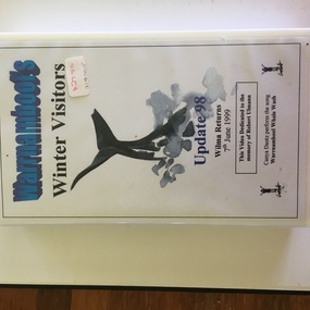 Warrnambool and District Historical Society Inc.
Audio Visual, Warrnambool Video Productions, Video - Winter Visitors, 1999
This videotape has material related to the annual arrival in Warrnambool’s coast (mainly at Logan’s Beach) of Southern Right Whales. These whales come annually to the Western District coastline about May and stay until about October. and some calve at Logan’s Beach – hence the name Logan’s Beach Whale Nursery. The whales have become an important tourist attraction in the area. Most of the whales return to the area regularly and have been named from their particular markings. Wilma the whale was a great favourite and was seen about every three years in Warrnambool but is now appearing in other parts of Australia. The tape is dedicated to Robert Ulmann who was a well-known artist and conservationist in the Warrnambool region. He did much to ensure the whales received protection and publicity in the Warrnambool environment. This tape is now in an outdated format and will be transferred to a more appropriate form as the material in it needs to be preserved. The whale migration to Warrnambool is a significant natural history event and material from the 1990s is important. This is a videotape in a black case with a white label with black printing pasted on. The outer box is white with a white label with blue and black printing. An image of a whale is on the outer label. ‘Warrnambool’s Winter Visitors’ ‘Update 98 Wilma Returns 7thJune 1999’ ‘This video dedicated to the memory of Robert Ulmann’ ‘Canya Dantz perform the song, Warrnambool Whale Wash’ whales in warrnambool, robert ulmann -
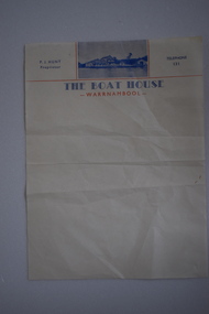 Warrnambool and District Historical Society Inc.
Letterhead, The Boat House Warrnambool, Mid 20th century
This is a letterhead from Proudfoot’s Boathouse in Warrnambool. Thomas Proudfoot built the boathouse near the mouth of the Hopkins River in 1885 and it was an accommodation and dining place for tourists, especially for those interested in fishing and other recreational pursuits and it was the base for the Hopkins Rowing Club. Proudfoot built additions in 1888 and 1893 and after he died in 1900 his wife Catherine continued on the business for over 30 years, transferring the licence to her son. In 1939 Thomas Proudfoot’s granddaughter, Ena Hunt gained the licence and operated the business with her husband Percy until 1979. It is Percy Hunt’s name on the letterhead described here. The business today is mainly centred around catering and dining. In the 1990s other buildings were added to the boathouse complex, with the original buildings now being heritage-listed. This item is of some interest as it is the only memento we have of the Hunt family’s 40 years proprietorship of Proudfoot’s Boathouse, a significant set of buildings in Warrnambool.This is a single sheet of cream coloured paper with blue and red printing and a blue-coloured photograph of Proudfoot’s Boat House. It is slightly creased.The Boat House Warrnambool P.J.Hunt Proprietor Telephone 131 proudfoots boat house warrnambool, p.j.hunt, the boat house warrnambool, history of warrnambool -
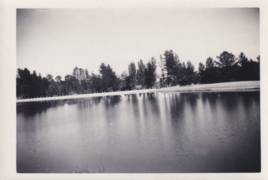
 Kiewa Valley Historical Society
Photograph of Kiewa Valley Panorama, Farming lands within the Kiewa Valley in1950s, Circa 1950
This photograph shows how (early to mid1900s), before the establishment of the Mount Beauty "gated" village, the Kiewa Valley was farmed and the scarce population was spread out over acres of productive land. This photograph catches a time before (what appeared to the local farmers as the invasion by a mass of construction workers) when this remote valley was part of a "lay back" rural landscape,occasionally visited by friends and some wayward tourists. The mountain ranges provided an adequate barrier against the way-would traveller. The immigration numbers coming into Australia was still quite small ( due to the "white" Australia policy) which was in force before World War II. After World War II a mass of displaced European refugees and migrants boosted the Australian population and provided for a greater degree of diverse professions and rural related work force.This photograph depicts the borderline in time between an exclusively rural based population and respective activities(early 1900s)to the present (2000 on wards) integrated village, tourist and retiree/holiday area. The time when land was exclusively used in agriculture is over and the impact of cheaper rural produce from Asian markets will see a shift of land useage and population activities. The Kiewa Valley is loosing its hiding place and is becoming more and more a source of untapped residential land. Black and white photograph of farming/grazing land useage, before the establishment of the Mount Beauty Village. Small pockets of residentual houses can be viewed. Road access (unsealed dirt) was typical of that provided in rural regions in the 1950s. The photo is on 200gms paper and not on photographic paper.kiewa valley in the early1900s, grazing in the kiewa valley, sec victoria -
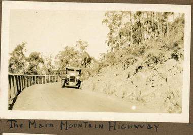 Mt Dandenong & District Historical Society Inc.
Photograph
The photograph shows an old car rounding a bend on what is now the Mt Dandenong Tourist Road. Around 1930 it would have been called the CRB Road or the Main Road. The photograph is in the Ivy Child Album. Ivy May Child (1910 – 1989) was the daughter of Arthur Edward (Ted) Child (1878 – 1964) and Ethel May Madden (1888 – 1970). Ted Child was the son of Matthew Francis Child (1839 – 1933) and Martha Jeeves (1857 – 1926). He was the grandson of one of the early pioneers Francis Child. Ivy grew up on the family property on Childs Road and took many photographs. Most of these are glued into her photo album. The album covered the years from c1927 – 1932. Ivy married Henry William Burgess (1906 – 1968) in 1944.Sepia coloured photograph showing an old car rounding a bend in the road.Below photograph in album: The Main Mountain Highwaymain road, crb road mt dandenong tourist road, car, automobile, ivy child, kalorama -
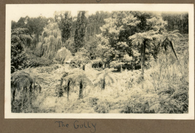 Mt Dandenong & District Historical Society Inc.
Photograph
The photograph is from the album of Ivy Child and shows a scene from Lyrebird gully that runs alongside the Olinda Falls. This has been a popular tourist area from the 1900s onwards. Ivy May Child (1910 – 1989) was the daughter of Arthur Edward (Ted) Child (1878 – 1964) and Ethel May Madden (1888 – 1970). Ted Child was the son of Matthew Francis Child (1839 – 1933) and Martha Jeeves (1857 – 1926). He was the grandson of one of the early pioneers Francis Child. Ivy grew up on the family property on Childs Road and took many photographs. Most of these are glued into her photo album. The album covered the years from c1927 – 1932. Ivy married Henry William Burgess (1906 – 1968) in 1944. The photographs remain in their original state in the album with individual copies made. Black and white photograph showing a bush setting with tree ferns and other trees.Written below the photograph in the album: THE GULLYlyrebird gully, tree ferns, bush, olinda falls