Showing 112677 items
matching tracks/roads
-
 Vision Australia
Audio - Sound recording, 2002 Carols by Candlelight conditions of entry, 2002
As people waited in queues to get into the 2002 Carols by Candlelight, the conditions of entry were played to the crowd. Different musical numbers were selected, with the same voice overlay to ensure that attendees were advised about safety, what was not allowed inside the venue, proceeds of sales and suggestions on how to minimise queue time.6 musical tracks with voice overlaycarols by candlelight, vision australia -
Vision Australia
Audio - Sound recording, 2011 Carols by Candlelight conditions of entry, 2011
As people waited in queues to get into the 2011 Carols by Candlelight, the conditions of entry were played to the crowd. Different musical numbers were selected, with the same voice overlay to ensure that attendees were advised about safety, what was not allowed inside the venue, proceeds of sales and suggestions on how to minimise queue time.6 musical tracks with voice overlaycarols by candlelight, vision australia -
 Orbost & District Historical Society
black and white photographs, 1976 - 1977
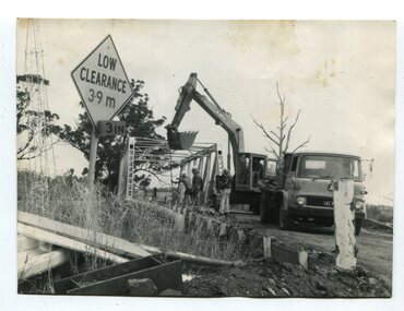
These photographs are of the demolition of the road bridge across the Snowy River at Orbost. This bridge over the Snowy River was opened on July 4 1922. It was constructed in 1922 alongside the previous suspension bridge. Its building was a combined effort of the Victorian Railways and the Country Roads Board at a cost of 35,000 pounds. It was replaced in 1976 by the present bridge after several major floods.This bridge was replaced in 1976 after several major floods. These photographs are pictorial records of its demolition.Four black / white photographs of the demolition of a road bridge across a river. In them can be seen trucks, excavators and workmen. In 3246.1 there is a triangular road sign - "LOW CLEARANCE 3.9m"bridge-demolition orbost-snwoy-river-bridge -
 Halls Gap & Grampians Historical Society
Photograph - B/W, C 1926
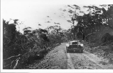
... Roads ...Mirranatwa Gap was originally known as Yarram Gap; this name was given to the opposite gap on the Mt William side of the Dunkeld Road sometime in the mid 20th century. An early touring car, claimed to be the first, crossing Mirranatwa (then Yarram) Gap.Photo shows car on Yarram Gap Road Road is rocky and unsealed. trees on left side of photo has been felledaccess routes, roads, yarram gap -
 Melbourne Tram Museum
Slide, Keith Caldwell, Apr. 1964
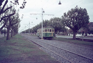
Agfa colour slide, blue / white plastic mount, photo by Keith Caldwell of W2 303 outbound in Dandenong Road, to Malvern Burke Road, route 5. Their are work lights strung along the overhead, track appears to have been relaid or reballasted. Tram has a 3XY radio station advert. 4/1964In ink "Relay Dand Rd 4-64"trams, tramways, w2 class, dandenong rd, route 5, malvern burke rd, trackwork, tram 303 -
 Geelong Cycling Club
Trophy, 1938
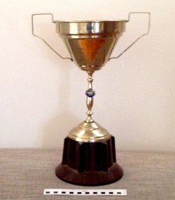
The winner of the race - Jack Baker was a cycling commentator In the 1920s, in the 1930s he cycled around Australia. In 1937 he rode in Europe and England representing Bruce Small for Malvern Star. Jack was well known for his commentary at races at the Geelong velodrome track after the war. The presentation of this trophy is another indicator of the popularity and importance placed on cycling races in regional areas during the early to mid 20th century.Silver plated cup on bakelite stand with engravings on the cup. The cup has two handles and a city of Geelong badge adhered to the stem."GWCC/1938/33 Mile Road Race/Pres By/F.W. Walker/Won By/J.J. Baker/Hcap Scratch Time 1hr27min12sec"geelong, cycling, club, gwcc, 1938, 33 mile road race, f.w. walker, j.j. baker -
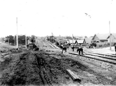
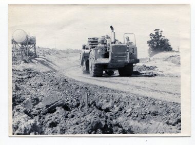 Orbost & District Historical Society
black and white photographs, C1975
These four photographs show the construction of the Princes Freeway on the eastern edge near the cemetery. of the Orbost township. The road is from the eastern entrance to the cemetery.These photographs are pictorial records of the construction of roads in Orbost.Four black / white photographs of road construction machinery.road-construction-orbost roadwork-orbost-cemetery -
 Linton and District Historical Society Inc
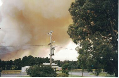
Photograph, Linton Bushfire, 1998, December 1998
Linton bushfire 1998, Snake Valley Road area, five Geelong West firefighters died in this fire.Colour photograph of bushfire smoke over Linton."Linton Fire December 2, 1998/Looking North on Skipton Road".bushfires -
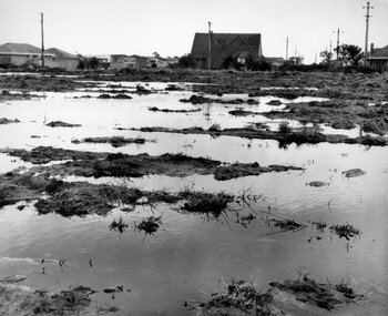 City of Kingston
Photograph - Black and white, c. 1958
... Roads ...Unsealed roads and drainage problems created difficulties for those living in Beaumaris during the 1950sBlack and white image depicting the Balcombe Road and Haywood Street, Beaumaris. Unsealed roads and drainage problems have created boggy slushy land. There are houses in the background, indicating people live in the area.Handwritten in red ink on reverse: 90% Handwritten in blue ink on reverse: 2193beaumaris, roads, drainage, water logged, housing -
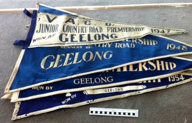 Geelong Cycling Club
Pennant Flags
These Pennant Flags were awarded to cycling clubs for road cycling competitions.The award of these pennants to the junior members of the Geelong West Cycling Club indicates the strength and popularity of competition cycling at the time.Triangular Pennant Flags. 3 flags are in blue felt with white inscriptions and one flag is in white felt with black inscriptions."VACU/Junior Country Road/ Premierships/Geelong/1947/1948/1950/1954"vacu; junior country road/; premierships; geelong; 1947; 1948; 1950; 1954; -
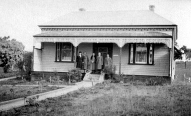 Linton and District Historical Society Inc
Photograph, Mrs. Norris' House, Linton, 1937
This house was sold by the Knights approx 1970, and moved to the Linton-Piggoreet Road.Black and white original photograph of five people standing on the verandah of a late Victorian house."Mrs Norriss's house Skipton road Linton 1937 later Knights home".houses, mrs norris, knight family -
 Sunbury Family History and Heritage Society Inc.
Photograph, Rosa McCall, Old Broadmeadows Township, 1949
The small town in the photograph is the former Broadmeadows Township (now part of Westmeadows). It was situated on the Old Sydney Road (Mickleham Road) and 2 miles east of the Broadmeadows Station. The stone bridge in the foreground spans the Moonee Ponds Creek and Fawkner Street is the road, which leads southwards to Gladstone Park and Tullamarine. The little building was a lolly shop that Mrs. Ethel Mitchell owned and ran for many years.Until 1869, before Sydney Road was finally opened, travellers on their way to Sydney would pass through the Broadmeadows Township.A copy of a non-digital black and white photograph of a road way with a bridge in the foreground leading to a small settlement. Small building with a pitched roof and a verandah is on the RHS of the image and the road leading out of the town is bordered with an avenue of pine trees.old broadmeadows township, fawkner street, moonee ponds creek, westmeadows, bridges -
 Robin Boyd Foundation
Slide, Robin Boyd, 1965
Colour slide in a mount. BP House (1964), St Kilda Road, Melbourne, Australia. (Architect: Anthony B Armstrong.)Made in Australia / 6 / JAN 65M / B-P St Kilda Road 1964 (Handwritten) / Detail: See also no.7. (Handwritten)melbourne, robin boyd, slide -
 Greensborough Historical Society
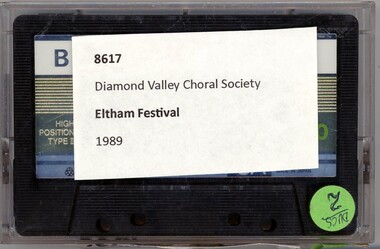
Audio - Audio Cassette, Diamond Valley Choral Society, Eltham Festival, performed by Diamond Valley Choral Society 1989, 1989
A recording of a backing tape for the Eltham Festival 1989. This performance is by the Diamond Valley Choral Society.1 audio cassette in clear plastic caseHandwritten on cassette: "Tracks 1-4. DVCS backing tape".diamond valley choral society, eltham festival -
Whitehorse Historical Society Inc.
Document, Ellis Stone's medisan planting, 1/05/2001 12:00:00 AM
'Ellis Stones' median planting, Canterbury Road, Vermont.'Ellis Stones' median planting, Canterbury Road, Vermont. Brochure describing median strip landscaping in Canterbury Road, Vermont undertaken by Ellis Stones in 1974 and details of proposed replanting.'Ellis Stones' median planting, Canterbury Road, Vermont. stones, ellis, canterbury road, vermont, roads and streets, landscape planning, city of whitehorse -
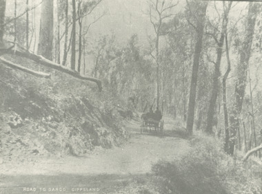 Lakes Entrance Historical Society
Photograph - road to Dargo Victoria, 1900 c
Road to Dargo GippslandBlack and white photograph of a horse drawn vehicle on a road through bushland on the way to Dargo Victoriatransport, roads and streets, topography -
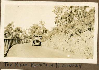 Mt Dandenong & District Historical Society Inc.
Photograph
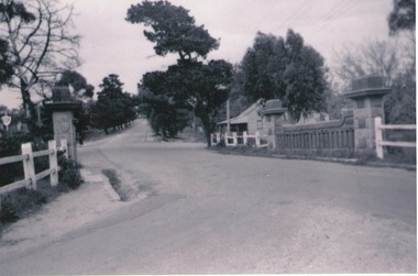
The photograph shows an old car rounding a bend on what is now the Mt Dandenong Tourist Road. Around 1930 it would have been called the CRB Road or the Main Road. The photograph is in the Ivy Child Album. Ivy May Child (1910 – 1989) was the daughter of Arthur Edward (Ted) Child (1878 – 1964) and Ethel May Madden (1888 – 1970). Ted Child was the son of Matthew Francis Child (1839 – 1933) and Martha Jeeves (1857 – 1926). He was the grandson of one of the early pioneers Francis Child. Ivy grew up on the family property on Childs Road and took many photographs. Most of these are glued into her photo album. The album covered the years from c1927 – 1932. Ivy married Henry William Burgess (1906 – 1968) in 1944.Sepia coloured photograph showing an old car rounding a bend in the road.Below photograph in album: The Main Mountain Highwaymain road, crb road mt dandenong tourist road, car, automobile, ivy child, kalorama -
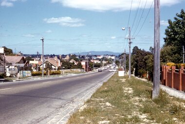 Surrey Hills Historical Society Collection
Photograph - Digital photograph, George L Coop, Whitehorse Road Mont Albert prior to widening, 1958, c1958
The donor George Lister Coop was about 21 years of age when he took this photo in 1958 before Whitehorse Road was widened. It was taken from adjacent to the Coop family home at No.688. Greythorn Caravans factory / showroom / yard was established c1953 at 731 Whitehorse Road. F R Horwood Wrought Iron at 733 Whitehorse Road was established in the 1940s.A digital copy of a colour photograph of Whitehorse Road, Mont Albert looking towards Box Hill. The Box Hill Gasworks can be seen in the middle distance. A caravan retailer can just be seen in the foreground on the northern side of Whitehorse Road.george l coop, whitehorse road, box hill gas works, mont albert, greythorn caravans, f r horwood wrought iron -
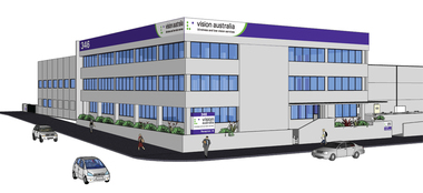 Vision Australia
Drawing - Image, Vision Australia Kensington exterior artists view, 2009
Artist impression of the new building for Vision Australia's office in Macaulay Road, Kensington in 2009.4 digital files depicting artists view of Macaulay Road officevision australia, macaulay road kensington -
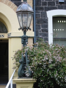 Vision Australia
Photograph - Image, Lamp post outside entry to St Kilda Road
Image taken of a lamp outside the reception door of the RVIB St Kilda Road building.1 col. image of lamp outside St Kilda Road buildingroyal victorian institute for the blind, fundraising -
 Eltham District Historical Society Inc
Slide, In Bonds Road south of the northern arm of Montpelier Drive, Lower Plenty, 18 July 1972, 1972
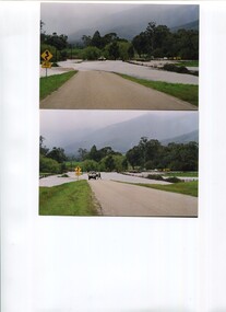
Water drainage work undertaken by Eltham Shire Council in Bonds Road, Lower Plenty outside the Martin property opposite Montpelier Drive, July 1972 Note the blocked pit full of water and water circumnavigating the pit.35 mm colour positive transparency Mount - Agfacolor Service (Blue)Bonds Road (Martin property) 12.10 pm 18.7.72bonds road, drainage works, eltham shire council, infrastructure, lower plenty, martin property, montpelier drive -
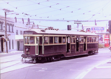 Kew Historical Society Inc
Photograph - W Class 380 turning out of Barkers Road into High Street South, 1990
This colour photograph, with 15 others are enlargements gifted to the Society by Mel Lawrence in 2016. They were taken at a commemorative event from the Kew Tram Depot. Laminated colour enlargement of W Class tram No.380 turning out of Barkers Road into High Street South, during a re-enactment in 1990.Annotation reverse: "Kew Depot 1990. W Class 380 turning out of Barkers Road into High Street South"kew tram depot, trams -- melbourne, a class trams -
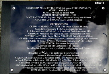 Bendigo Military Museum
Weapon - TANK, CENTURION, C.1952
This item is on display in the gardens of the Bendigo District RSL Sub Branch Havilah Road. Refer photo .1) for details re manufacture, history and use..1) Plaque metal black on a stand with details re the item. .2) Centurion Main Battle Tank Model Mark 5/1, complete with motor, painted green colour, tracked vehicle.brsl, smirsl, bdrslinc, tank, centurion -
 Ballarat Tramway Museum
Photograph - Geelong Tramway North line
Men laying sleeper tram tracks for the North tram route along The Esplanade. In the midddle distance, the double track towards the city is in Mercer St. (now The Esplanade South). The street off to the left is Victoria Tce., (now Western Beach Road). 1928Black and white print on paper.GRS710/25/1/10 and 25-10, written on the reverse in paper. The No., 2 inside a circle, written on the reverse in ink.geelong tramway, geelong tramway laying sleeper tracks -
 City of Kingston
Pamphlet - Colour, Brock Bros, South Brighton Township Estate, 1888
Sales plan for land in the suburb of South Brighton (Moorabbin), bounded by Point Nepean Road, South Road, Patterson Street and the Mordialloc Railway Line. Incorporates Wolsely Street and Gordon StreetThe developing urban area of Moorabbin within the City of Kingston. This land sale pamphlet illustrates the subdivision of land within the municipality and the changing demographic of the district as new houses are constructed close to infrastructure.Colour pamphlet advertising for private sale the South Brighton Township Estate, South Brighton. Incorporates a map of the estate bordered by Point Nepean Road, South Road, Patterson Street, and the Mordialloc Railway Line. Includes Wolsley Street and Gordon Street. land sales, south brighton, estate, moorabbin -
Whitehorse Historical Society Inc.
Document, History of Tally Ho Boys Home, 1972
Three papers on History of Boys Training Farm, Highbury Road, Tally Ho3 papers on History of Boys Training Farm, Highbury Road, Tally Ho, commenced in 1903 by Rev. and Mrs George Cole. The story covers the period from 1903-1930. The farm was built on land bought from Abel Hoadley for 1,000 Pounds near the corner of Springvale Road in Boundary Road (now Highbury Road). 2 letters (16/7/1972 & 28/5/1972) to Nancy Leach from E. Hinneberg, Assistant Superintendent, Tally Ho, about his association with Tally Ho.Three papers on History of Boys Training Farm, Highbury Road, Tally Hoyouth services, tally ho boys home, cole, george, rev., cole, mrs, hoadley, abel, boundary road burwood east, highbury road, burwood east, springvale road, burwood east, leach, nancy, hinneberg, ernest. -
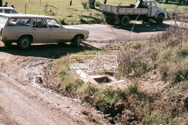
 Kiewa Valley Historical Society
Photos - x2 Damms Road River Crossing
Damms Road river crossing after the c1993 floods of the Kiewa River. The old bridge was inundated, later to be washed away.The Kiewa River flooded in 1993 at Damms Road when the old bridge was washed away.2 coloured photos of the Kiewa River in flood at Damms Roadkiewa river flooding, bridge at damms road -
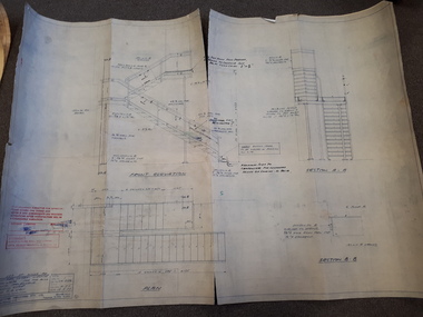 Vision Australia
Plan - Image, Section B.B (stairwell), 12/5/1977
Architectural drawing for the completion of a outside stairway at St Kilda Road. Detailed drawing of the stairs, including specifications and measurements and shows the front elevation and two sections.1 architectural plan of stairwell at St Kilda RoadCraftsteel Industries Pty Ltdroyal victorian institute for the blind, plans -
 Ballarat Tramway Museum
Photograph - Digital image, John Theodore, c1973
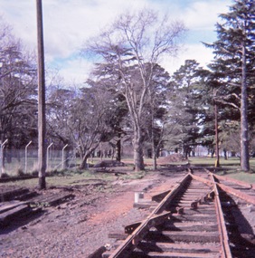
Yields information about the BTPS constructing No. 1 road at the depot.Digital images scanned from 35mm slides of the construction of 1 road points, first half of 1973. Points and crossings installed and poles installed. Little segments of rail have been laid out to indicate the position of the track.trams, tramways, btps, trackwork, depot, overhead -
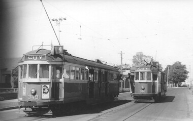 Melbourne Tram Museum
Photograph - Black and White - Trams 349 & 661, Truganini Road Carnegie, John Alfred
Photo shows W2 349 and W3 661 in Glenhuntly Road / Truganini Road Carnegie (route 4) at the start of the single line to the terminus, with the drivers "exchanging the staff" for the section. The destination of 349 has already been changed. Note the warning sign above the drivers of the Single line section. Photo possibly 1950s.Yields information about the use of the short single line just before the Carnegie terminus.Photograph - Black and White - Trams 349 & 661, Truganini Road CarnegieHas details on rear in ink and John Alfred Stamp.tramways, tramcars, carnegie, truganini road, single line, staff, w2 class, w3 class, tram 661, tram 349, glenhuntly road