Showing 1293 items matching "victorian maps"
-
 Victorian Railway History Library
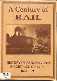
Book, Gould, George, A Century of Rail: History of Rail Services Birchip and District 1893-1993, 1993
A history of the Victorian Railway's railway extension from Donald to Birchip in western Victoria to mark the centenary of its opening.ill, maps, p.118.non-fictionA history of the Victorian Railway's railway extension from Donald to Birchip in western Victoria to mark the centenary of its opening.railroad construction - victoria - history, railroads -- victoria -- history -
 Victorian Railway History Library
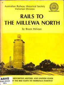
Book, McLean, Bruce, Rails To The Millewa North, 1975
A history of the Victorian Railway's railway from Red Cliffs to Morkalla in far North West Victoria and a lineside guide for the occasion of the 'Back to Millewa' celebrations on 14 & 15 June 1975.ill, maps, p.60.non-fictionA history of the Victorian Railway's railway from Red Cliffs to Morkalla in far North West Victoria and a lineside guide for the occasion of the 'Back to Millewa' celebrations on 14 & 15 June 1975.railroad construction - victoria - history, railroads -- victoria -- history -
 The Beechworth Burke Museum
Geological specimen - Slice Dendrites on Sandstone, Unknown
Dendrites are deposits of black minerals, typically manganese oxides that precipitated from water seeping through fractures in fine-grain rocks like a sandstone or limestone. Dendrites are much less regular than plant fossils and lacks vein structures. The manganese cryztallizes through the process called 'supercooling'. Some samples of dendrites occur in volcanic rocks in the Lilydale district, east of Melbourne. Sandstones are made of tiny sand grains that may have been deposited in the sea and later formed together. Most sandstones are made of quartz which are chemically-resistant minerals. This particular specimen was donated by Alfred Selwyn in 1868 as part of the Geological Survey of Victoria. It is connected to the original 1875 catalogue on Geological Specimen with number 189 'Quartz Crystals_Quartz Crystals (two are polished)'Dendrites on sandstones This specimen is an important contribution to the geological history of Victoria, as well as its links to the 1868 Geological Survey of Victoria. This specimen is part of larger collection of significant geological specimens in the Burke Museum that was collected from around the world between 1868-1880. A large percentage of these specimens were collection as part of the Geological Survey of Victoria 1852-1974. The Geological Survey of Victoria was an organisation founded in response to the Victorian gold rush to explore the geological and mineral resources and to record a detailed map of the state. It was headed by British geologist, Alfred Richard Cecil Selwyn (1824-1902), who was responsible for issuing over 60 geological maps during his 17 years as director. These maps were all hand-drawn and coloured and became the benchmark for accuracy for geological mapping. Collecting geological specimens was an important part of mapping and understanding the scientific makeup of the earth. Many of these specimens were sent to research and collecting organisations across Australia, including the Burke Museum, to educate and encourage further study. A hand-sized slice of light brown sandstone with dendrites formed from crystallized manganese oxide.Existing label: Not sure what / 'Slica dondrites' / means. / Sample is sandstone and original label / identifies it as from / the Grampians near Stawell. / C. Willman / 15/4/21 Other label: [illegible] / stone [ illegible] / from Grampians Stawell / 1894 /geological specimen, geology, geology collection, burke museum, beechworth, dendrites, sandstones, quartz, lilydale district, geological survey of victoria, grampians, victoria rocks, minerals, rocks, manganese oxides, alfred selwyn -
 The Beechworth Burke Museum
Geological specimen - Fossil Leaves
A fossil refers to any remains or traces of past life that are preserved in the rock. It could be remains of plants or animals. Fossil leaves are commonly found on different types of rocks. These fossils can go as far back as the Triassic Age just like the series of fossil plants collected at Denmark Hill, Ipswich in Queensland. Fossils leaves are formed when dead plants get buried by sediments like mud, sand, or volcanic ash. Often, it gets detached cleanly from stems along a special layer of weak cells, then twigs, and, less commonly, cones of conifers and fruits and seeds of flowering plants. Over time, the leaves or pieces of leaves get buried by more sediments and eventually gets 'lithified' or hardened into a rock. Erosions and mining can cause the rocks to break and reveal the fossils buried in it. Fossilisation frequently takes place at sites in the lowlands where deposits of clay, silt, sand are found. This is usually due to weathering and erosion of rocks. Fossil leaves can provide information about ancient Australia's way of living. It contributes to Victorian biodiversity records and its botanical collections. It also contributes information on the geographical profile of Victoria as fossilisation usually occur at estuaries and deltas of rivers, river flood plains, ponds and lakes. This specimen is part of a larger collection of geological and mineral specimens collected from around Australia (and some parts of the world) and donated to the Burke Museum between 1868-1880. A large percentage of these specimens were collected in Victoria as part of the Geological Survey of Victoria that begun in 1852 (in response to the Gold Rush) to study and map the geology of Victoria. Collecting geological specimens was an important part of mapping and understanding the scientific makeup of the earth. Many of these specimens were sent to research and collecting organisations across Australia, including the Burke Museum, to educate and encourage further study.Piece of light brown rock with fossilised leaves in shades of golden yellow and brown.Existing label: Fossil Leaves / Locality unknown / might be worth checking if this is Glossopteris, a Permian age plant. / C. William 16/4/21 geological specimen, geology, geology collection, burke museum, beechworth, fossil leaves, fossilization, 1868 geological survey of victoria, lithified, rocks, fossilised leaf, rock, fossils, leaves -
 Melbourne Tram Museum
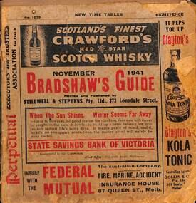
Book - Bradshaws Guide - November 1941, Stillwell & Stephens Pty Ltd
Provides detailed information on Victorian railways country timetables, suburban trains, lists of post offices, Victorian and Commonwealth Government officials and elected representatives, and tramways - all night services, first and last cars, including Sandringham and St Kilda services. Provides a detailed guide to services in Victoria, including public transport.Book - 194 pages, 9 sections stapled paper titled "Bradshaws Guide - November 1941" Priced 8d, No. 1029. Has a fold out map of the VR Country and suburban lines. Includes many advertisements.victoria, tramways, melbourne, timetables, railways, guides, bradshaws guide, advertisements -
 Victorian Railway History Library
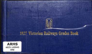
Book, The Association of Railway Enthusiasts, 1927 Victorian Railways Grades Book, 1975
... maps, p.197. 1927 Victorian Railways Grades Book Book ...A reprinted edition of the gradiant and curvature diagrams of all the Victorian Government Railways in 1927maps, p.197.A reprinted edition of the gradiant and curvature diagrams of all the Victorian Government Railways in 1927railway infrastructure - victoria, railroad operations - victoria - history -
 Victorian Railway History Library
Book, The Association of Railway Enthusiasts, 1927 Victorian Railways Grades Book - Supplementary Diagrams
... maps, p.198. 1927 Victorian Railways Grades Book ...A reprinted edition of the gradiant and curvature diagrams of all the Victorian Government Railways in 1927maps, p.198.A reprinted edition of the gradiant and curvature diagrams of all the Victorian Government Railways in 1927railway infrastructure - victoria, railroad operations - victoria - history -
 Vision Australia
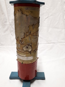
Map - Object, R.F. Tunley, Braille cylinder map, 1940-1950s
This map was produced by Richard Francis Tunley and given to the Victorian Braille Library for use by it's patrons. Mr Tunley was a prolific Braille map maker as well as producing other items for blind and vision impaired children, advocated for compulsory education for blind and deaf children and established the Queensland Braille Map and Model Club. Leading by example, his maps were treasured by those who used them and were an outstanding piece of craftsmanship. In this example, the metal cylinder sits on a wooden base and can be turned via a handle in the wooden top or rotating the sides. A brailled red metal plate occupies the bottom third, and large continents have a metal plate, cut to shape, upon which braille country/continent names are placed. Major rivers are traced through raised lines in the metal continental plates, twisted wire traces shipping routes with associated brailled metal plates, raised metal pins in some major locations and more explanatory plates sit in various oceans.1 metal cylindrical map with tactile markersCommercial & Strategic Map of the British Empire Presented to the Victorian Braille Librarybraille library of victoria, r.f. tunley -
 Melbourne Tram Museum
Map - CD - Sands McDougal Map Melbourne c1906, Sands McDougall
Detailed scan of the Sands McDougal Map in colour showing Melbourne's cable trams, railways, Essendon Tramways, NMETL and the Victorian Railways line to Brighton from St Kilda. Includes the MTOCo horse tram lines and the Caulfield horse tram lines. See Reg item 6572 for the actual map. Yields information about Melbourne and its tramways in 1906CD in a plastic case - black with clear cover.CD marked "Sands & McDougal Map c1906"cable trams, tramways, map, sands mcdougal, nmetl, vr trams, horse trams -
 Victorian Railway History Library
Book, Turton, Keith et al, The Ararat Railway Centenary 1875-1975, 1975
A history of the Ballarat to Ararat railway in western Victoria and a lineside guide to the stations on the line. The book was issued by the Australian Railway Historical Society, Victorian Division on the occasion of the Centenary Celebrations of the opening of the railway to Ararat on the 5th April 1875.ill, maps, p.60.non-fictionA history of the Ballarat to Ararat railway in western Victoria and a lineside guide to the stations on the line. The book was issued by the Australian Railway Historical Society, Victorian Division on the occasion of the Centenary Celebrations of the opening of the railway to Ararat on the 5th April 1875.railroad construction - victoria - history, railway services: ballarat-ararat railway. victoria. ararat region -
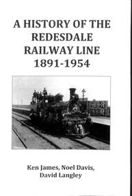 Victorian Railway History Library
Book, James, Ken et al, A History of the Redesdale Railway Line 1891-1954, 2014
A comprehensive history of the Victorian Railway's branch line from Kyneton to Redesdale in Victoria from 1891 to 1954.index, ill, maps, p.238.non-fictionA comprehensive history of the Victorian Railway's branch line from Kyneton to Redesdale in Victoria from 1891 to 1954.railroad construction - victoria - history, railroads -- victoria -- redesdale -- history -
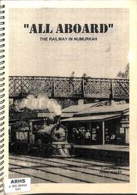 Victorian Railway History Library
Book, Sigley, John, All Aboard The Railway in Numurkah, 2002
A history of the Victorian Railway's line to Numurkah and its branch line to Picola in Victoria.ill, maps, p.65.non-fictionA history of the Victorian Railway's line to Numurkah and its branch line to Picola in Victoria.railroad construction - victoria - history, numurkah -- railways -- history -
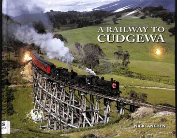 Victorian Railway History Library
Book, Anchen, Nick, A Railway To Cudgewa, 2013
A history of the Victorian Railway's branch line from Wodonga to Cudgewa in Victoria.ill, maps, p.122.non-fictionA history of the Victorian Railway's branch line from Wodonga to Cudgewa in Victoria.railroad construction - victoria - history, railroads - victoria - cudgewa - history -
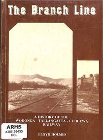 Victorian Railway History Library
Book, Holmes, Lloyd, The Branch Line: A History of the Wodonga - Tallangatta - Cudgewa Railway, 2013
A short history of the Victorian Railway's branch line from Wodonga to Cudgewa in Victoria.ill, maps, p.104.non-fictionA short history of the Victorian Railway's branch line from Wodonga to Cudgewa in Victoria.railroad construction - victoria - history, railroads - victoria - cudgewa - history -
 Victorian Railway History Library
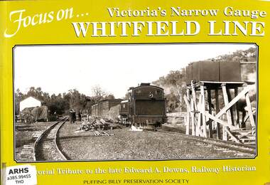
Book, Thompson, John E, Focus On... Victoria's Narrow Gauge Whitefield Line, 2002
A Pictorial history of the Victorian Railways narrow gauge 2'6" branch line from Wangaratta to Whitfield and a tribute to the late Edward A. Downs, Railway Historian.ill, maps, p.41.non-fictionA Pictorial history of the Victorian Railways narrow gauge 2'6" branch line from Wangaratta to Whitfield and a tribute to the late Edward A. Downs, Railway Historian.railroad construction - victoria - history, railroads - victoria - whitfield - history -
 Victorian Railway History Library
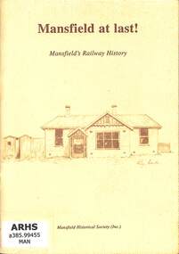
Booklet, Mansfield Historical Society, Mansfield at last! Mansfield's Railway History, 1994
A brief history of the Victorian Railway's branch line from Tallarook to Mansfield.index, ill, maps, p.29.non-fictionA brief history of the Victorian Railway's branch line from Tallarook to Mansfield.railroad construction - victoria - history, railroads - victoria - mansfield - history -
 Victorian Railway History Library
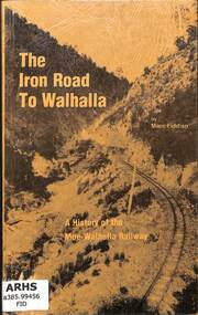
Book, Fiddian, Marc, The Iron Road To Walhalla, 1981
A history of the Victorian Railway's narrow gauge 2'6" branch line from Moe to Walhalla.index, ill, maps, p.100.non-fictionA history of the Victorian Railway's narrow gauge 2'6" branch line from Moe to Walhalla.railroad construction - victoria - history, vr narrow gauge railways - victoria - history -
 Bendigo Historical Society Inc.
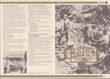
Document - CENTRAL GOLDFIELDS RESTORATION FUND, March 1986
Pamphlet on the Central Goldfields Restoration Fund issued by the Victorian Ministry for Planning and Environment. Includes a map of the central goldfields region, introduction by Jim Kennan (Minister) and 3 photographs. Also a description on how the fund operates and how to apply for assistance. An insert of 2 blank application forms. Photos show , Miners using a sluice at Tarnagulla c.1880. Cnr of Sturt and Lydiard Sts, Ballarat c.1880. E. Eberhard Cordial Factory at Clunes c.1890.Victorian Ministry for Planning and Environmentorganization, government, central goldfields, restoration fund, ministry for planning and environment, j. kennan, tarnagulla, ballarat, clunes. -
 Whitehorse Historical Society Inc.
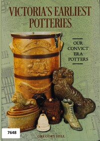
Book - Manufacturing History, 19th century, Victoria's Earliest Potteries (Our Convict Era Potters), 2019
This book covers the formative years of Victoria's pottery industry during the second half of the 19th Century. It includes a section on Nunawading's Dahle's Filter and Pottery Works operating between 1870 and1876.This book covers the formative years of Victoria's pottery industry during the second half of the 19th Century. It includes a section on Nunawading's Dahlke's Filter and Pottery Works operating between 1870 and1876. The White Bros acquired the pottery in 1888 and called it Springfield Pottery (1888-1911).non-fictionThis book covers the formative years of Victoria's pottery industry during the second half of the 19th Century. It includes a section on Nunawading's Dahle's Filter and Pottery Works operating between 1870 and1876.potteries, dahlke's filter and pottery works, geal's pottery, daniel robertson, australian tesselated tile company, wunderlich, 1800's -
 Flagstaff Hill Maritime Museum and Village
Document - Plan, Victorian Harbours Warrnambool, Victorian Harbours, Warrnambool, Plan to Accompany Sir John Coode's Report, 28-02-1879
This plan is of great significance to the local history of Warrnambool, in particular the Breakwater and its impact on Warrnambool's maritime and trade history. The plan shows the existing jetties at the Port of Warrnambool, plus the partially erected Breakwater and proposed works to the Breakwater by both the Borough of Warrnambool Surveyor and Sir John Coode. The plan was signed 28th February 1879 by Sir John Coode. The legend at the bottom left describes the existing works and the proposed works. The Warrnambool Breakwater Sir John Coode was a British harbour engineer. He was brought to Melbourne by the Melbourne Harbour Trust to advise on works to improve the Port of Melbourne. The Victorian Government commissioned him to present a plan to complete the Warrnambool Breakwater. His original plan was too expensive so he prepared a revised plan for a shorter structure. The work was completed in 1890. The construction proved to be too short to protect adequately from the weather and didn't allow enough depth for larger vessels to come into port. The decreasing trade was further affected by siltation in the bay due to the breakwater, and the completion of the railway line. The situation of the harbour became a real problem that, by 1910, required continuous dredging. In 1914 the Breakwater was extended but proved to be a failure because the work began to subside and by 1920 about two thirds of the harbour was silted up. Alterations made in the 1920's increased the silting problem and by the 1940's the harbour was no longer used. More alterations were made in the 1950's and 1960's. The Warrnambool Breakwater is registered as a place of significance on the Victorian Heritage Database. This plan of the proposed works for the existing Warrnambool Breakwater is of great significance to the local history of Warrnambool, in particular the Breakwater and its impact on Warrnambool's maritime and trade history. The Warrnambool Breakwater is registered as a place of significance on the Victorian Heritage Database (VHR H2024). It is historically significant to Victoria as one of the most important maritime engineering projects in Victoria in the late 19th century. The Warrnambool Breakwater is of historical significance as one of the most important maritime engineering projects in Victoria in the late nineteenth century. It is evidence of Victoria's nineteenth century investment in regional port infrastructure and the development of Victorian coastal shipping. It is of significance for its association with the English civil engineer Sir John Coode, the most distinguished harbour engineer of the nineteenth century, who was brought to Victoria to advise on works to improve the Port of Melbourne, but was retained by the Government to advise on improvements to the harbours at Portland, Geelong, Port Fairy, and Lakes Entrance, as well as Warrnambool. His projects for Melbourne, Lakes Entrance and Warrnambool were major engineering projects of the nineteenth century. The breakwater is historically significant as a reminder of Warrnambool's early maritime history as a Western District port, and as one of Victoria's major 'outer ports'. While the Warrnambool Breakwater is a demonstration of the engineering skills of the nineteenth century, it also demonstrates the limitations of knowledge relating to sedimentology at the time and the confidence apparent in a number of nineteenth century plans which assumed that natural forces could be overcome or contained by engineering.Plan of Warrnambool Harbour, Port of Warrnambool, dated 28 Feb 1879. Plan shows existing Breakwater and work proposed by both Warrnambool Borough Surveyor and Sir John Coode. Plan has gold coloured quarter-dowel rods top and bottom and a metal ring at the top. Stamped with title. Signed by Sir John Coode.Stamped "VICTORIAN HARBOURS / WARRNAMBOOL / PLAN / to accompany / SIR JOHN GOODE'S REPORT / DATED 28 FEB 1879" Signature "John Coode"flagstaff hill, warrnambool, maritime museum, shipwreck coast, great ocean road, sir john coode, borough of warrnambool surveyor, plan of warrnambool, victorian harbours, warrnambool harbour, warrnambool breakwater, port of warrnambool, vhd vhr h2024, flagstaff hill maritime museum & village, maritime village, map, chart, plan, lady bay, breakwater, jetty, pier, vhr h2024, proposed works, 1879 -
 Victorian Railway History Library
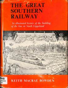
Book, Bowden, Keith Macrae, The Great Southern Railway, 1970
A illustrated history of the building of the line in South Gippsland Victoria.index, ill, maps, p.130.A illustrated history of the building of the line in South Gippsland Victoria.south gippsland - railways - history, railroad construction - victoria - history -
 Victorian Railway History Library
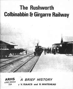
Book, Australian Railway Historical Society (Victorian Division) et al, The Rushworth Colbinabbin and Girgarre Railway, 1973
A brief history of the Rushworth, Colbinabbin & Girgarre Railway as part of tour notes for a trip by the Australian Railway Historical Society on the 21st July 1973.ill, maps, p.23.non-fictionA brief history of the Rushworth, Colbinabbin & Girgarre Railway as part of tour notes for a trip by the Australian Railway Historical Society on the 21st July 1973.railroad construction - victoria - history, australian railway historical society - tours -
 Stawell Historical Society Inc
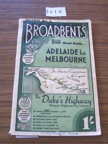
Book, Broadbent directory, Broadbent's Official : Speedo Strip Road Guide, 1943
Maps and descriptions of towns on the Western Highway & Dukes Highway from Melbourne to Adelaide. Sponsored by R.A.C.V and The Victorian Government Tourist BureauCream paper cover back border with green filling with a map from Melbourne to AdelaideBroadbeants Official Speedo Strip guide Melbourne to Adelaidestawell transport -
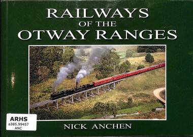 Victorian Railway History Library
Book, Anchen, Nick, Railways of the Otway Ranges, 2011
A pictorial history of railways in the Victorian Otway Ranges including the Victorian Railways lines to Wensleydale, Forrest and Timboon as well as the 2'6" narrow gauge railway to Crowes.ill, maps, p.96.non-fictionA pictorial history of railways in the Victorian Otway Ranges including the Victorian Railways lines to Wensleydale, Forrest and Timboon as well as the 2'6" narrow gauge railway to Crowes.railroad construction - victoria - history, logging railroads - victoria - otway range - history -
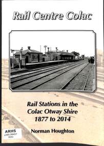 Victorian Railway History Library
Book, Houghton, Norm, Rail Centre Colac, 2014
An history of the rail stations on the Victorian Railways lines in the Colac Otway Shire including the lines to Forrest, Alvie, Cressy and the 2'6" narrow gauge railway to Crowes.index, ill, maps, p.262.non-fictionAn history of the rail stations on the Victorian Railways lines in the Colac Otway Shire including the lines to Forrest, Alvie, Cressy and the 2'6" narrow gauge railway to Crowes.railroad construction - victoria - history, logging railroads - victoria - otway range - history -
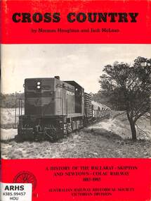 Victorian Railway History Library
Book, Houghton, Norm et al, Cross Country: A History of the Ballarat-Skipton And Newtown-Colac Railway 1883-1985, 1986
A brief history of the Victoria Railways cross country line from Ballarat to Skipton and Colac in the South West.index, ill, maps, p.64.non-fictionA brief history of the Victoria Railways cross country line from Ballarat to Skipton and Colac in the South West.railroad construction - victoria - history, railways - south west victoria - history -
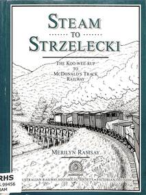 Victorian Railway History Library
Book, Ramsay, Merilyn, Steam to Strzelecki, 1991
A history of the Koo-Wee-Rup to McDonald's Track (Strzelecki) Railway in South Gippsland Victoria.index, ill, maps, p.150.non-fictionA history of the Koo-Wee-Rup to McDonald's Track (Strzelecki) Railway in South Gippsland Victoria.railroad construction - victoria - history, railroads -- victoria -- gippsland -- history -
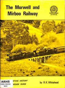 Victorian Railway History Library
Book, Whitehead, Robert, The Morwell and Mirboo Railway, 1974
A lineside guide and history of the Morwell to Mirboo North Railway in Gippsland Victoria. Issued on the occasion of the running of the 'Last Train' between Morwell and Mirboo North prior to closure of the line on the 22nd June 1974.ill, maps, p.65.non-fictionA lineside guide and history of the Morwell to Mirboo North Railway in Gippsland Victoria. Issued on the occasion of the running of the 'Last Train' between Morwell and Mirboo North prior to closure of the line on the 22nd June 1974.railroad construction - victoria - history, railroads -- victoria -- gippsland -- history -
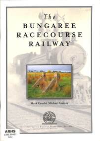 Victorian Railway History Library
Book, Cauchi, Mark et al, The Bungaree Racecourse Railway, 2009
An illustrated history narrative of Victorian Railways line from Bungaree to the Bungaree Racecourse near Ballarat.index, ill, maps, p.40.non-fictionAn illustrated history narrative of Victorian Railways line from Bungaree to the Bungaree Racecourse near Ballarat.railroad construction - victoria - history, railways - bungaree racecourse - history -
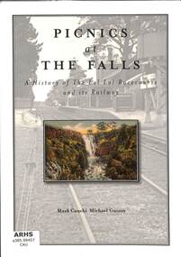 Victorian Railway History Library
Book, Cauchi, Mark et al, Picnics at The Falls: A History of the Lal Lal Racecourse and its Railway, 2017
An illustrated history narrative of Victorian Railways line from Lal Lal to the Lal Lal Racecourse near Ballarat.index, ill, maps, p.87.non-fictionAn illustrated history narrative of Victorian Railways line from Lal Lal to the Lal Lal Racecourse near Ballarat.railroad construction - victoria - history, railways - lal lal racecourse - history