Showing 6941 items matching "view street"
-
 The Beechworth Burke Museum
Photograph, c1960
The photograph depicts a view across the water at Lake Sambell. The image is thought to date from the 1960s so may show the lake during a period of drought, such as that experienced across South-Eastern Australia in 1967. The present day park and reserve occupies the site of the former Rocky Mountain Mining Company, an open-cut sluice mine that began operations in the mid-Nineteenth Century and operated until the early 1900s, through the peak of Victoria’s Gold Rush. It was converted into a park and leisure area in the 1920s. Lake Sambell was formally opened to the public on Friday 5th October 1928 and was opened by the Victorian Government’s Minister of Lands, Mr Bailey, as part of initiatives to boost the economies and development of country towns. The lake was named after Mr L.H. Sambell, a shire engineer and secretary of the Forward Beechworth Committee who was involved in promoting the transformation of the mining site and promoting plantation forestry and tourism as alternative industries. £300 to begin the process was provided by Mr J. McConvill, a former resident of Beechworth, who is remembered in a street name adjacent to the lake. Residents of Beechworth have worked to raise funds to improve the Lake Sambell reserve several times, such as efforts in the 1930s and 1940s to raise the banks several feet to deepen the water for swimming purposes. Fundraising campaigns include the ‘Ugly Man’ competition conducted on behalf of the Wallace Park-Lake Sambell Development Scheme. The latter competition was run by the Fire Brigade Bend’s team as part of a larger competition called the ‘Mile of Pennies’; it was won by Mr Len Knight of Beechworth’s Commercial Hotel. The ‘Mile of Pennies’ was conducted at a Carnival held on New Year’s Eve, 1947. It was proposed by the Beechworth and District Progress Association. As well as improving swimming facilities, funds were raised to install a caravan park facility near the lake. Funds were also donated by commercial entities, such as £250 received from Zwar Bros. Pty Ltd.The photograph is significant as it shows Lake Sambell at lower water levels, such as may have been experienced during period of drought.Sepia rectangular photograph printed on matte photographic paperObverse: nil Reverse: 3470beechworth, beechworth lake, lake sambell, lake, beechworth and district progress association, forward beechworth committee, ugly man, mile of pennies, wallace park lake sambell development scheme, wallace park-lake sambell development scheme, zwar bros, zwar, l.h. sambell, j. mcconvill, minister of lands, commercial hotel, len knight, rocky mountain mining company, rocky mountain mining co, gold rush, redevelopment, transformation, community fundraising, drought, 1967, 1960s -
 The Beechworth Burke Museum
Photograph, Unknown
Aerial view of Lake Sambell, Beechworth with town views. Lake Sambell is a beautiful Victorian recreation lake and urban park with a unique history. It was created in the mid-1800s by the Rocky Mountain Mining company during the gold rush era and used as a mining site until the early 1900s, which brought Europeans into the area. It was turned into a reserve for residents in 1920 and is considered an icon of Beechworth as it represents the development of the community, human endeavour, and the spirit of the landscape.This photograph represents Lake Sambell with town views.Black and white reproduced rectangular photograph print on paper.Reverse: Stampbeechworth lake, lake sambell, aerial photo, construction, australian landscape, #beechworth, victoria -
 The Beechworth Burke Museum
Photograph, c1960
The photographs in this set depict views across the water at Lake Sambell. The images date from approximately 1960. The present day park and reserve occupies the site of the former Rocky Mountain Mining Company, an open-cut sluice mine that began operations in the mid-19th Century and operated until the early 1900s, through the peak of Victoria’s Gold Rush. It was converted into a park and leisure area in the 1920s. Lake Sambell was formally opened to the public on Friday 5th October 1928 and was opened by the Victorian Government’s Minister of Lands, Mr Bailey, as part of initiatives to boost the economies and development of country towns. The lake was named after Mr L.H. Sambell, a shire engineer and secretary of the Forward Beechworth Committee who was involved in promoting the transformation of the mining site and promoting plantation forestry and tourism as alternative industries. £300 to begin the process was provided by Mr J. McConvill, a former resident of Beechworth, who is remembered in a street name adjacent to the lake. Residents of Beechworth have worked to raise funds to improve the Lake Sambell reserve several times, such as efforts in the 1930s and 1940s to raise the banks several feet to deepen the water for swimming purposes. Fundraising campaigns include the ‘Ugly Man’ competition conducted on behalf of the Wallace Park-Lake Sambell Development Scheme. The latter competition was run by the Fire Brigade Bend’s team as part of a larger competition called the ‘Mile of Pennies’; it was won by Mr Len Knight of Beechworth’s Commercial Hotel. The ‘Mile of Pennies’ was conducted at a Carnival held on New Year’s Eve, 1947. It was proposed by the Beechworth and District Progress Association. As well as improving swimming facilities, funds were raised to install a caravan park facility near the lake. Funds were also donated by commercial entities, such as £250 received from Zwar Bros. Pty Ltd.The photographs are significant as they show the level of development in Beechworth in the middle of the Twentieth Century. Four sepia and black and white rectangular photographs printed on matte photographic paper. 3469.1: Obverse: nil Reverse: 3469-1 3469.2: Obverse: nil Reverse: 3469-2 3469.3: Obverse: nil Reverse: 3469-3 3469.4: Obverse: nil Reverse: 3469-4beechworth, beechworth lake, lake sambell, lake, beechworth and district progress association, forward beechworth committee, ugly man, mile of pennies, wallace park lake sambell development scheme, wallace park-lake sambell development scheme, zwar bros, zwar, l.h. sambell, j. mcconvill, minister of lands, commercial hotel, len knight, rocky mountain mining company, rocky mountain mining co, gold rush, redevelopment, transformation, community fundraising -
 The Beechworth Burke Museum
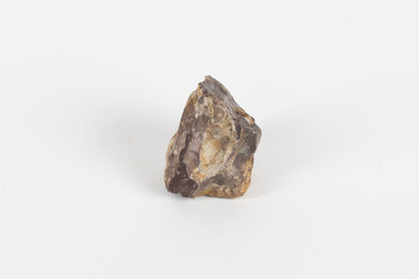
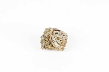
Geological specimen - Common Opal, unknown
Common Opal is a mineraloid that is non crystallising and is classed as an amorphous silicate, the chemical composition for Opal is SiO2 nH2O. Opals can develop in weathered sedimentary rock typical in arid regions where limited water enters small gaps in the rock, and the silicate is hydrated. Common opals, unlike precious opals, do not exhibit ‘play of colour’ in which the colour appears to change depending on the angle of view. While precious opals are highly valuable and cut as gemstones for jewellery, common opals can be cut into inexpensive gemstones and are also mined for various uses including as ingredients in ceramics, insulation, fillers, and abrasives. The source of this common opal specimen is unknown, but common opals are found around the world, notable deposits are found in Queensland, South Australia, New South Wales, Peru, Kenya, Nevada, Oregon, and Mexico. This common opal specimen is of historic and scientific significance due to its donation in 1868 as part of the Geological Survey of Victoria and as a typical example of uncut common opal. This specimen is part of a larger collection of geological and mineral specimens collected from around Australia (and some parts of the world) and donated to the Burke Museum between 1868-1880. A large percentage of these specimens were collected in Victoria as part of the Geological Survey of Victoria that begun in 1852 (in response to the Gold Rush) to study and map the geology of Victoria. Collecting geological specimens was an important part of mapping and understanding the scientific makeup of the earth. Many of these specimens were sent to research and collecting organisations across Australia, including the Burke Museum, to educate and encourage further study.A palm-sized amorphous (non-crystallising) hydrated silicate mineraloid specimen in shades of brown, orange, and white.Existing label: Common Opal / Locality unknowngeological specimen, geology, geology collection, burke museum, beechworth, common opal, opal, mineraloid, amorphous silicates, hydrated silicate -
 The Beechworth Burke Museum
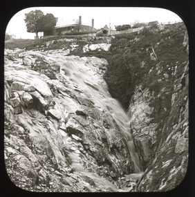
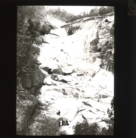
Photograph - Lantern Slide, c1900
This image shows the gorge adjacent to Beechworth in approximately 1900. Although the exact location of the photograph is yet to be determined, the present-day Beechworth Gorge Walk includes views of the Cascades at the point at which Spring Creek flows into the valley on the level below. Gold-sluicing techniques in use in the town during periods of active gold extraction may have altered the landscape since the photograph was taken, however. In the 1850s a mill was built at the top of the Spring Creek falls by Russian-born Louis Chevalier, brother of artist Nicholas Chevalier. The mill supplied the town with lumber that supported the town's initial construction boom. Lantern slides, sometimes called 'magic lantern' slides, are glass plates on which an image has been secured for the purpose of projection. Glass slides were etched or hand-painted for this purpose from the Eighteenth Century but the process became more popular and accessible to the public with the development of photographic-emulsion slides used with a 'Magic Lantern' device in the mid-Nineteenth Century. Photographic lantern slides comprise a double-negative emulsion layer (forming a positive image) between thin glass plates that are bound together. A number of processes existed to form and bind the emulsion layer to the base plate, including the albumen, wet plate collodion, gelatine dry plate and woodburytype techniques. Lantern slides and magic lantern technologies are seen as foundational precursors to the development of modern photography and film-making techniques.This glass slide is significant because it provides insight into Beechworth's built environment and natural landscape in the early Twentieth Century, around the time of Australia's Federation. It is also an example of an early photographic and film-making technology in use in regional Victoria in the time period.Thin translucent sheet of glass with a square image printed on the front and framed in a black backing. It is held together by metals strips to secure the edges of the slide.burke museum, beechworth, lantern slide, slide, glass slide, plate, burke museum collection, photograph, monochrome, indigo shire, north-east victoria, spring creek falls, beechworth gorge, louis chevalier, nicholas chevalier, lumber industry, timber industry, 1850s, construction, building, mill, mills, waterfall -
 The Beechworth Burke Museum
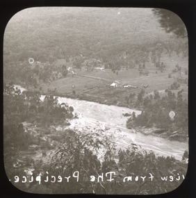
Photograph - Lantern Slide, c1900
This image shows a semi-aerial view of a property along a river adjacent to Beechworth in approximately 1900. The photographer has capitalised words in the label, indicating that 'The Precipice' may have suggested a particular rather than a general vantage point to local people at the time. Although the exact location of the photograph is yet to be determined, Beechworth Gorge is popular today with hikers and nearby Mt Stanley is noted for its views. Lantern slides, sometimes called 'magic lantern' slides, are glass plates on which an image has been secured for the purpose of projection. Glass slides were etched or hand-painted for this purpose from the Eighteenth Century but the process became more popular and accessible to the public with the development of photographic-emulsion slides used with a 'Magic Lantern' device in the mid-Nineteenth Century. Photographic lantern slides comprise a double-negative emulsion layer (forming a positive image) between thin glass plates that are bound together. A number of processes existed to form and bind the emulsion layer to the base plate, including the albumen, wet plate collodion, gelatine dry plate and woodburytype techniques. Lantern slides and magic lantern technologies are seen as foundational precursors to the development of modern photography and film-making techniques.This glass slide is significant because it provides insight into Beechworth's built environment and natural landscape in the early Twentieth Century, around the time of Australia's Federation. It is also an example of an early photographic and film-making technology in use in regional Victoria in the time period.Thin translucent sheet of glass with a square image printed on the front and framed in a black backing. It is held together by metals strips to secure the edges of the slide.Obverse: Image from The Precipice. /burke museum, beechworth, lantern slide, slide, glass slide, plate, burke museum collection, photograph, monochrome, views, landscapes, farmsteads, rivers, beechworth gorge, mt stanley, emulsion, the precipice -
 The Beechworth Burke Museum
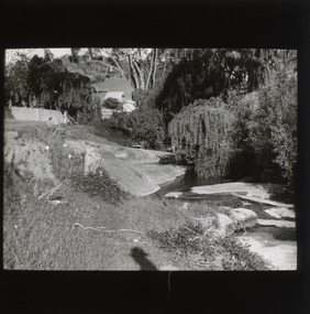
Photograph - Lantern Slide, c1900
This image shows a view of a properties bordering a river in the vicinity of Beechworth in approximately 1900. Although the exact location of the photograph is yet to be determined, the water source pictured may feed into the bigger system that flows through Beechworth Gorge. A man wearing a hat, possibly the photographer, is silhouetted in the foreground of the picture. Lantern slides, sometimes called 'magic lantern' slides, are glass plates on which an image has been secured for the purpose of projection. Glass slides were etched or hand-painted for this purpose from the Eighteenth Century but the process became more popular and accessible to the public with the development of photographic-emulsion slides used with a 'Magic Lantern' device in the mid-Nineteenth Century. Photographic lantern slides comprise a double-negative emulsion layer (forming a positive image) between thin glass plates that are bound together. A number of processes existed to form and bind the emulsion layer to the base plate, including the albumen, wet plate collodion, gelatine dry plate and woodburytype techniques. Lantern slides and magic lantern technologies are seen as foundational precursors to the development of modern photography and film-making techniques.This glass slide is significant because it provides insight into Beechworth's built environment and natural landscape in the early Twentieth Century, around the time of Australia's Federation. It is also an example of an early photographic and film-making technology in use in regional Victoria in the time period.Thin translucent sheet of glass with a square image printed on the front and framed in a black backing. It is held together by metals strips to secure the edges of the slide.burke museum, beechworth, lantern slide, slide, glass slide, plate, burke museum collection, photograph, monochrome, photographer, beechworth gorge, river, stream, water source, 1900s -
 The Beechworth Burke Museum
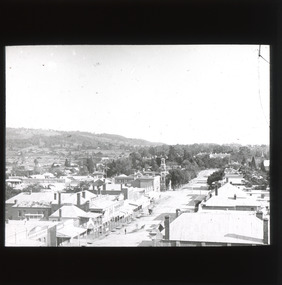
Photograph - Lantern Slide, c1900
This image shows a semi-aerial view of commercial and official properties lining Ford Street, Beechworth, in approximately 1900. The tower of Christ Church of St Peter and St Paul can be seen in the middle section of the photograph, on the left-hand side of the street. The Church was constructed in 1858 with the tower added to the structure in 1864. Lantern slides, sometimes called 'magic lantern' slides, are glass plates on which an image has been secured for the purpose of projection. Glass slides were etched or hand-painted for this purpose from the Eighteenth Century but the process became more popular and accessible to the public with the development of photographic-emulsion slides used with a 'Magic Lantern' device in the mid-Nineteenth Century. Photographic lantern slides comprise a double-negative emulsion layer (forming a positive image) between thin glass plates that are bound together. A number of processes existed to form and bind the emulsion layer to the base plate, including the albumen, wet plate collodion, gelatine dry plate and woodburytype techniques. Lantern slides and magic lantern technologies are seen as foundational precursors to the development of modern photography and film-making techniques.This glass slide is significant because it provides insight into Beechworth's built environment and commercial and official infrastructure in the early Twentieth Century, around the time of Australia's Federation into one nation. It is also an example of an early photographic and film-making technology in use in regional Victoria in the time period.Thin translucent sheet of glass with a square image printed on the front and framed in a black backing. It is held together by metals strips to secure the edges of the slide.burke museum, beechworth, lantern slide, slide, glass slide, plate, burke museum collection, photograph, monochrome, ford street, christ church of st peter and st paul, church tower, landmarks, 1900, shopping facilities, public buildings, 1900s, built environment, streetscape -
 The Beechworth Burke Museum
Photograph - Lantern Slide, c1900
This image shows the gorge adjacent to Beechworth in approximately 1900. Although the exact location of the photograph is yet to be determined, the present-day Beechworth Gorge Walk includes views of the Cascades at the point at which Spring Creek flows into the valley on the level below. Gold-sluicing techniques in use in the town during periods of active gold extraction may have altered the landscape since the photograph was taken, however. In the 1850s a mill was built at the top of the Spring Creek falls by Russian-born Louis Chevalier, brother of artist Nicholas Chevalier. The mill supplied the town with lumber that supported the town's initial construction boom. Lantern slides, sometimes called 'magic lantern' slides, are glass plates on which an image has been secured for the purpose of projection. Glass slides were etched or hand-painted for this purpose from the Eighteenth Century but the process became more popular and accessible to the public with the development of photographic-emulsion slides used with a 'Magic Lantern' device in the mid-Nineteenth Century. Photographic lantern slides comprise a double-negative emulsion layer (forming a positive image) between thin glass plates that are bound together. A number of processes existed to form and bind the emulsion layer to the base plate, including the albumen, wet plate collodion, gelatine dry plate and woodburytype techniques. Lantern slides and magic lantern technologies are seen as foundational precursors to the development of modern photography and film-making techniques.This glass slide is significant because it provides insight into Beechworth's built environment and natural landscape in the early Twentieth Century, around the time of Australia's Federation. It is also an example of an early photographic and film-making technology in use in regional Victoria in the time period.Thin translucent sheet of glass with a square image printed on the front and framed in a black backing. It is held together by metals strips to secure the edges of the slide.burke museum, beechworth, lantern slide, slide, glass slide, plate, burke museum collection, photograph, monochrome, beechworth gorge, indigo shire, landscapes, mill, sluicing, gold mining, north-east victoria, spring creek, louis chevalier, cascades -
 The Beechworth Burke Museum
Geological specimen - Cerussite, Unknown c.1890s
Named in 1845 by Wilhelm Karl von Haidinger cerussite takes its name from the Latin cerussa, meaning 'white lead'. When viewed under certain lighting conditions cerussite gives of fire and rainbow-like colours (due to its high dispersion) and it is quite sought after by geological collectors for this very reason. Cerussite is usually found in the oxidised zone of lead ore deposits. It is a very common weathering product of galena and other lead ore minerals. It is a secondary mineral, meaning it forms as a result of the alteration of pre-existing minerals in the Earth’s crust. The presence of lead in cerussite makes it potentially toxic. Historically, it has been an important source of lead, which has numerous industrial applications, including in batteries, construction materials, and radiation shielding. Cerussite has a crystal structure that belongs to the orthorhombic crystal system. Its crystal structure is characterized by a three-dimensional arrangement of atoms in a repeating pattern. The crystal lattice of cerussite consists of interconnected lead (Pb) and carbonate (CO3) ions. This crystal structure is visible in the specimen. This specimen was found in Dundas (formerly Mount Dundas), a historical mining locality, mineral field and railway located on the western foothills of the West Coast Range in Western Tasmania. During the 1890s Dundas swelled in numbers however it is now lost in a temperate rainforest and its population is now 2. The present Dundas Extended mine, about 1.5 km east of Dundas is presently worked for specimen material.Faceted cerussite gems are considered rare and valuable, given the softness of the mineral. This item is not a faceted gem however its historical and scientific research potential give it significance; mined in an Australian township, this cerussite could shed light on the now lost history of Dundas and the mining that occurred there. Additionally, the uses of this mineral in historical industrial processes give it scientific significance. Such knowledge can add to understandings of the geographical and geological nature of Western Tasmania and allow for further study of Australian geological specimens. A small lead carbonite mineral with shades of cream, white and brown throughout, flaky shards of white at base. CERUSSITE / (lead carbonite) / Locality: Dundas, W. Tasmaniadundas, tasmania, cerussite, lead, orthorhombic, geology, minerals, mining -
 Orbost & District Historical Society
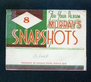
photographs, Murray Studio, Murray Views, 1940's 1950's
This collection of photographs produced by Murray Views, Gympie, features eight scenic black / white photographic prints of Orbost and surrounding tourist areas.Photographs like these allowed tourists to send many images of their holiday destination or hometown in the one small package. Fred Murray opened Murray Studios in Gympie in 1906. The postcard and souvenir production side of the business initially covered Gympie and surrounding regions, but Murray expanded the business to include North Queensland, NSW and even Adelaide. It was opened under a separate name, Murray Views, in 1929. In 1945 the business was taken over by Murray’s nephews who began postcard folder production.These photographs are a useful research material.A white envelope with green and white print containing eight photographs of the Orbost area. It is titled For Your Album Murray's Snapshotssouvenir photographs-orbost postcards -
 Orbost & District Historical Society
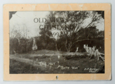
calendar, Old Views of Gippsland 1993, 1992
This item is a useful pictorial reference tool.A 1992 stapled pictorial annual calendar, titled "Old Views of Gippsland".On the front is a black/white photograph of "The Hut Belle Vue" taken by H.D. Bulmer. It contains early photographs of East Gippsland, one for each month. The photographs are sepia. There is a hole for hanging. Some dates have appointments recorded in pen.calendar-old-views-of-gippsland photographs-historic-gippsland -
 Orbost & District Historical Society
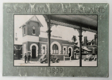
calendar, Old Views of Gippsland 1990, 1998
This is a useful pictorial reference tool.A 1999 stapled calendar, titled "Old Views of Gippsland".On the olive green coloured front is a black/white photograph of 1950's Bairnsdale Post & Telegraph Offiice. It contains early photographs of East Gippsland, one for each month. There is a hole for hanging. calendar-old-views-of-gippsland photographs-historic-gippsland -
 Orbost & District Historical Society
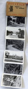
post cards, ca. 1945
This is a souvenir of Orbost from 1945.A set of 13 black and white postcards in a fold-out format. Pictures are of : Nicholson Street, Snowy Rriver flats from Grand View, avenue leading to Obost. Snowy River bridge at Orbost, Snowy River at Orbost, Marlo from the sand dunes, Prince's Highway at Victorian-NSW. border, Genoa River and bridge at Genoa, Prince's Highway at Mt. Drummer, Cann River hotel, fern scene, Euchre Valley, ponsasinorum near Cann River. SOUVENIR Orbost to Vic Border 13 camera viewspostcard souvenir photographs orbost cann-river -
 Orbost & District Historical Society
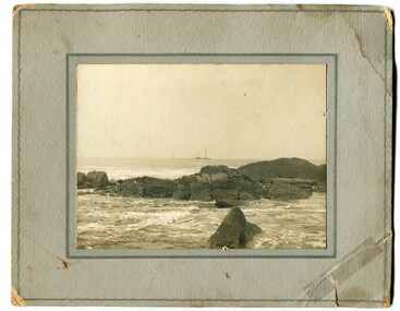
black and white photograph
Could be Cape Conran. Both Ruby Richardson and Mr O. S. Green have associations with the Orbost district.A black / white photograph mounted on a grey buff card. It shows an ocean view with a ship in the background, rocks in the foreground.on back - "From Ruby Richardson - Mr O. S. Green"ocean-east-gippsland-sailing-ship -
 Orbost & District Historical Society
black and white photograph, 1900
This photograph was taken in 1900 at Buchan. The River View Hotel was established in Buchan in 1884 and was possibly first called the Cricket Club Hotel. The isgn at the front of the building suggests that a ? Cameron ran the establishment.This an early pictorial record of Buchan in the 1900s.A small black / white photograph of a group of people standing outside a hotel A motor vehicle is in the foreground and another behind the people. On the right side of the wooden building is a sign indicating that this is River View House an accommodation business. At the front is a sign with the name ?. Cameron on it.on front - "Buchan Caves - 1900" on back - "E.A. Paige"buchan-river-view-hotel -
 Orbost & District Historical Society
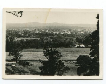
black and white photograph, late 19th / early 20th century?
This photograph shows a distant view of the Orbost township taken from Grandview Lookout at Newmerella. It appears to have been taken before the railway line was there.This is a pictorial record of early Orbost.A small black / white photograph of the Orbost township taken from Grandview Lookout , Newmerella. The main road can be seen below with paddocks of crops on both sides.on back - "Distant View, Orbost from Grandview"orbost-township-c19th grandview-lookout orbost-flats-paddocks -
 Orbost & District Historical Society
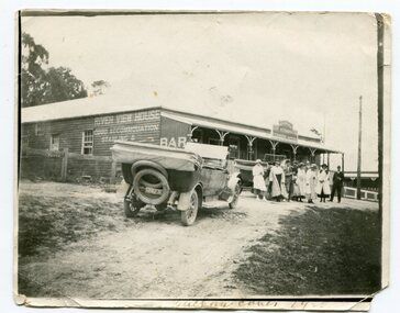
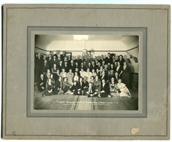
black and white photograph, March 1937
This is a photograph of the "Diggers Reunion" for the "Back To" celebrations held in Orbost in March 1937.This is a pictorial record of a significant event in Orbost's history.A black / white photograph on a grey buff card. It shows a large group of people sitting or standing on the floor of what appears to be a church hall.on back - "Mrs Mars. View St ?????????" on front - "Diggers Reunion Back to Celebrations Orbost 3.3.37"orbost-back-to-celebration festivals -
 Orbost & District Historical Society
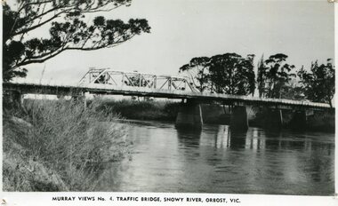
black and white photograph, Murray Studio, Murray Views, 1934
After the flood damage of 1934, the bridge was repaired with a new section in the middle. This bridge remained largely unchanged until its final demolition in 1975 after construction of the new concrete bridge and Orbost by-pass which exists today. This photograph is one of a collection of photographs produced by Murray Views, Gympie. It features eight scenic b/w photographic prints of Orbost and surrounding tourist areas.Photographs like these allowed tourists to send many images of their holiday destination or hometown in the one small package. Fred Murray opened Murray Studios in Gympie in 1906. The postcard and souvenir production side of the business initially covered Gympie and surrounding regions, but Murray expanded the business to include North Queensland, New South Wales and even Adelaide. It was opened under a separate name, Murray Views, in 1929. In 1945 the business was taken over by Murray’s nephews who began postcard folder production. This is a pictorial record of an early bridge across the Snowy River at Orbost.A black / white photograph / postcard of the Snowy River Bridge at Orbost.on front bottom printed - Murray Views No.4 Traffic Bridge , Snowy River, Orbost, Vic.orbost-snowy-river-bridge -
 Orbost & District Historical Society
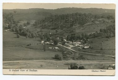
black and white photograph, Howard D. Bulmer, first half 20th century
This is a pictorial record of Buchan in the first half of the 20th century.A black / white photograph / postcard of a township in a valley. The photograph has been taken from a distance.on front - A Distant View of Buchanbuchan -
 Orbost & District Historical Society
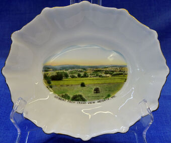
dish, 1950-1970
Small china pieces carrying scenic views of holiday destinations were a popular kind of souvenir during much of the 20th century. The pictures on the souvenirs ranged across natural beauty spots (beaches, waterfalls, rivers), civic buildings and monuments (town halls, war memorials), and indicators of local progress (commercial centres and occasionally even industrial sites). Ref: Powerhouse Museum Sydney.Small souvenir dish. White with gold edging and a picture of Orbost in bottom centre. Picture is a view from Grandview Heights. White, square, bone china dish with fluted rim trimmed with gold. In the centre of the dish there is a coloured transfer of a scene labelled as 'Sturt Street, Ballarat'. The scene shows grand Victorian buildings in the background, shops with verandahs and verandah posts lining one side of Sturt Street, trees on the other side of the street, and a tram in the foreground. A transfer on the underside gives manufacturer's information. Read more: http://www.powerhousemuseum.com/collection/database/?irn=12118#ixzz23rwkysrO Under Creative Commons License: Attribution Non-CommercialUnderneath- Royal Stafford -Bone China, Made in England, 3444 Top- Orbost From Grandview Heights, Vic.souvenir dish orbost grandview-heights crockery domestic stafford-royal -
 Orbost & District Historical Society
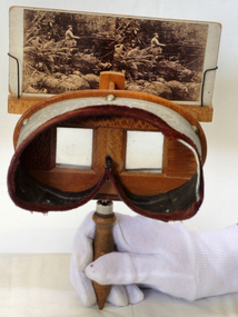
stereoscope, April 1920
This is a wood stereoviewer with folding handle The viewer has two lenses at a set distance in the wooden hood which is lined in green velvet. The pictures can be moved vertically on the slide holder in order to focus them. These devices became popular in the middle of the 19th century. This is probably a Holmes type stereoscope, named after its inventor, Oliver Wendell Holmes (1860). Velvet lined view mask with engravwed patterns. Frame is silky oak wood with a handle underneath.stereoscope audio-visual appliances -
 The Beechworth Burke Museum
Photograph
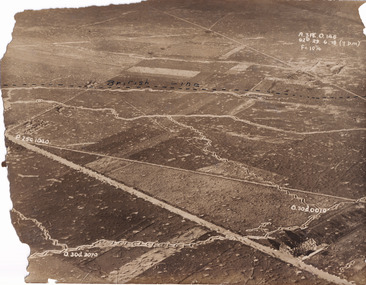
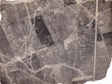
Taken some time between 1914-18, the photograph depicts an aerial view of trenches in France. The image mostly shows rural landscape, although there is a house in the bottom right corner. A dotted line has been drawn across the photograph, marking the section of trenches that belonged to British forces during World War I. It is believed that the line marking on this record denotes a section of the Western Front. The Western Front was the main theatre of war during World War I. Following the outbreak of war in August 1914, the German Army opened the Western Front by invading Luxembourg and Belgium, then gaining military control of important industrial regions in France. The German advance was halted with the Battle of the Marne. Following the Race to the Sea, both the French-British and German armies dug in along a meandering line of fortified trenches, stretching from the North Sea to the Swiss frontier with France. Between 1915 and 1917 there were several offensives along the Western Front. The attacks employed massive artillery bombardments and massed infantry advances. Entrenchments, machine gun emplacements, barbed wire and artillery repeatedly inflicted severe casualties during attacks and counter-attacks and no significant advances were made. Among the most notable of these offensives were the Battle of Verdun (1916), the Battle of the Somme (1916), and the Battle of Passchendaele (1917).The record is historically significant due to its connection to World War I. This conflict is integral to Australian culture as it was the single greatest loss of life and the greatest repatriation of casualties in the country's history. Australia’s involvement in the First World War began when the Australian government established the Australian Imperial Force (AIF) in August 1914. Immediately, men were recruited to serve the British Empire in the Middle East and on the Western Front. The record has strong research potential. This is due to the ongoing public and scholarly interest in war, history, and especially the ANZAC legend, which is commemorated annually on 25 April, known as ANZAC Day.Sepia rectangular photograph printed on matte photographic paper.Obverse: A.3FE.O.146 / G2R 29 . 6 . 18 (Y p.m) / F= 10 1/4 / British Line / ------------------------------------------ / P. 250 1040 / 0. 30d. 0010 / 0. 30d. 3070 /military album, military, war, wwi, world war i, france, great britain, trenches, village, rural, western front -
 The Beechworth Burke Museum
Photograph
Taken some time between 1914-18, the photograph depicts an aerial view of trenches in France. The image mostly shows rural landscape, although there is a cluster of houses in the top right corner. It is believed that this record denotes a section of the Western Front. The Western Front was the main theatre of war during World War I. Following the outbreak of war in August 1914, the German Army opened the Western Front by invading Luxembourg and Belgium, then gaining military control of important industrial regions in France. The German advance was halted with the Battle of the Marne. Following the Race to the Sea, both the French-British and German armies dug in along a meandering line of fortified trenches, stretching from the North Sea to the Swiss frontier with France. Between 1915 and 1917 there were several offensives along the Western Front. The attacks employed massive artillery bombardments and massed infantry advances. Entrenchments, machine gun emplacements, barbed wire and artillery repeatedly inflicted severe casualties during attacks and counter-attacks and no significant advances were made. Among the most notable of these offensives were the Battle of Verdun (1916), the Battle of the Somme (1916), and the Battle of Passchendaele (1917).The record is historically significant due to its connection to World War I. This conflict is integral to Australian culture as it was the single greatest loss of life and the greatest repatriation of casualties in the country's history. Australia’s involvement in the First World War began when the Australian government established the Australian Imperial Force (AIF) in August 1914. Immediately, men were recruited to serve the British Empire in the Middle East and on the Western Front. The record has strong research potential. This is due to the ongoing public and scholarly interest in war, history, and especially the ANZAC legend, which is commemorated annually on 25 April, known as ANZAC Day.Black and white rectangular photograph printed on matte photographic paper.Obverse: A.3.FE.2.291 / 62D O.20bd.P.25O.C / 16.7.18 / 12 / F 8 1/4 / Reverse: 6532military album, military, army, war, wwi, world war i, france, trenches -
 The Beechworth Burke Museum
Photograph
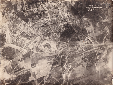
Taken some time between 1914-18, the photograph depicts an aerial view of Villers-Bretonneux in France, a region which was part of the Western Front during World War I. The image mostly shows rural landscape. The Western Front was the main theatre of war during World War I. Following the outbreak of war in August 1914, the German Army opened the Western Front by invading Luxembourg and Belgium, then gaining military control of important industrial regions in France. The German advance was halted with the Battle of the Marne. Following the Race to the Sea, both the French-British and German armies dug in along a meandering line of fortified trenches, stretching from the North Sea to the Swiss frontier with France. The First Battle of Villers-Bretonneux occurred between 30 March - 5 April 1918. It took place during Operation Michael, part of the German Spring Offensive on the Western Front. The offensive began against the British Fifth Army and the Third Army on the Somme, and pushed back the British and French reinforcements on the north side of the Somme. The capture of Villers-Bretonneux, close to Amiens, a strategically important road and rail-junction, would have brought the Germans within artillery-range. In late March, troops from the Australian Imperial Force were brought south from Belgium as reinforcements to help shore up the line. In early April, the Germans launched an attack to capture Villers-Bretonneux. After a determined defence by British and Australian troops, the attackers were close to success until a counter-attack by the 9th Australian Infantry Brigade and British troops late in the afternoon of 4 April restored the situation and halted the German advance on Amiens. The Second Battle of Villers-Bretonneux occurred between 24 - 27 April 1918, during the German Spring Offensive to the east of Amiens. It is notable for being the first occasion on which tanks fought against each other. A counter-attack by two Australian brigades and a British brigade during the night of 24 April partly surrounded Villers-Bretonneux, and on 25 April, the town was recaptured. On 26 April, the role of the Moroccan division of the French army was crucial in pushing back German units. Australian, British and French troops nearly restored the original front line by 27 April.The record is historically significant due to its connection to World War I. This conflict is integral to Australian culture as it was the single greatest loss of life and the greatest repatriation of casualties in the country's history. Australia’s involvement in the First World War began when the Australian government established the Australian Imperial Force (AIF) in August 1914. Immediately, men were recruited to serve the British Empire in the Middle East and on the Western Front. Additionally, the record's significance is enhanced by its depiction of Villers-Bretonneux. The battles that occurred in this town during World War I are especially historically significant to Australia as this is where the Australian Imperial Force had one their greatest World War I victories. An Australian flag still flies over Villers-Bretonneux in the present. Furthermore, a plaque outside the Villers-Bretonneux Town Hall recounts the battles fought to save the town in 1918. Kangaroos feature over the entrance to the Town Hall, and the main street is named Rue de Melbourne. More officially, recognition of the significance of the battle in Villers-Bretonneux is found at the Australian National Memorial, which was built just outside the town. It commemorates all Australians who fought in France and Belgium and includes the names of 10,772 who died in France and have no known grave. Each year, a small ceremony is held at the memorial to mark the sacrifice made by the soldiers. Lastly, the record has strong research potential. This is due to the ongoing public and scholarly interest in war, history, and especially the ANZAC legend, which is commemorated annually on 25 April, known as ANZAC Day.Sepia rectangular photograph printed on matte photographic paper.Obverse: yAE.2.35. / 125 / 62d.2834.35.36.VA.5. / 12.G.18-11 / F.-(?)" /military album, wwi, world war i, villers-bretonneux, australian imperial force, aif, france, war, army, conflict, germany, 1918, battle -
 The Beechworth Burke Museum
Photograph
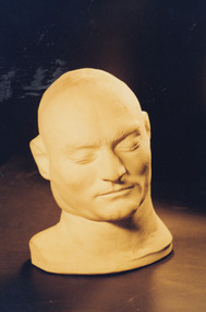
A death mask is a plaster or wax mould made of a human face shortly after death (around 30 minutes after the execution). The intention was to capture the likeness of the individual and maintain their facial expression and features before these became distorted in death. They differ from their counterparts the life masks which were made to preserve the likeness of an individual while alive. Death masks were often replicated and sold to various institutions and private buyers. Death masks were created for a variety of reasons. Organisations like museums and scientific institutes collected these masks to support the study of phrenology. Phrenology is the study of the conformation of a skull in an effort to understand the mental faculties and traits of an individual. This was undertaken in a period in which it was argued that the shape of a head could provide detailed knowledge into personality. In addition, death masks were also created to aid effigy making, as tools for sculpture and as objects of veneration. Death masks were often placed on display as objects of curiosity. Edward “Ned” Kelly was convicted of murder on the 29th of October 1880 and executed by hanging on the 11th of November that same year. In the 1800s it was common practice for authorities to make a death mask of an executed criminal. In Kelly’s case, there were multiple copies made of his death mask, one of which is in the collection of the Burke Museum. Copies of the official death Mask (attributed to Maximilian Kreitmayer) have been made by artists including Max Meldrum (1875-1955). It depicts the head, neck and partial right shoulder of Ned Kelly. Whilst generally considered to be a ‘pseudoscience’ today, phrenology and the study of the reception and use of artefacts like Ned Kelly’s death mask, can provide valuable insight into a past era’s views of personality and the human body. This mask presents a unique three-dimensional depiction of Ned Kelly shortly after his execution which is unlike any other depiction of him. It can provide vital information as to the use of death masks in Victoria and their popularity in the 1800s. These masks were mostly done of criminals and used for exhibition purposes alongside phrenological study. Phrenologist AS Hamilton used Kreitmayer’s replication of the mask (displayed in Kreitmayer’s Bourke Street waxworks the day after Kelly’s death) to report a detailed phrenological analysis on Ned Kelly and concluded from his research that the deceased had an “enormous self-esteem”. Portraits of living people represent the way they themselves and/or the artists wished themselves to be remembered. The death mask contrasts this and therefore, creates a likeness of a person in their entirety and not just an ideal representation. Therefore, the study of such artefacts and their history of use and disuse can provide interesting information valuable to understanding the past. Colour rectangular photograph printed on gloss photographic paper.Obverse: Reverse: AGFA kelly album, ned kelly, death mask, kreitmayer, old melbourne gaol, phrenology, craneology, 1800s, pseudoscience, burke musuem, max meldrum -
 The Beechworth Burke Museum
Photograph, Bayless C. - Manager, 1875
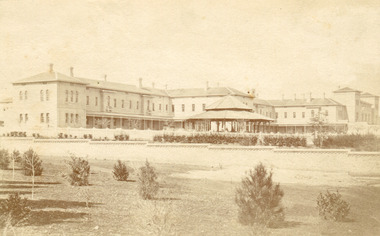
In this photo, taken in around 1875, is depicted the exterior of the Beechworth Mental Asylum buildings, with the administration buildings far right of the photo. A sunken boundary wall in the foreground and some people in view, sitting at the pavillion in the centre of the image. The two-storey buildings, designed in Italianate style, and the three-storey towers at the front, influenced by the asylum at Colney Hatch in England. The architecture of the buildings shares key features with other contemporary institutions, like Aradale at Ararat, and its design is attributed to the Public Works Department architect, J.J. Clark, whose name is connected with the construction of many other important public buildings, such as the Asylums at Kew and Ararat, the front block of the Royal Mint, Melbourne and the Melbourne Customs House. The Mayday Hills Hospital was constructed between 1864 and 1867, with buildings created in a number of periods. It formally opened on 24 October 1867 and, along with the Ovens Hospital and the Benevolent Asylum, made Beechworth a prominent social welfare centre in Victoria. Large masses of granite were excavated for its foundation and around 250 workmen were employed for its construction. The building, divided into six sections, was comprised of dormitories, doctors` rooms and plenty ancillary rooms and facilities, such as laundries, reading rooms, a concert hall and cooking areas. The site was chosen for its panoramic view of the countryside, the hilltop atmosphere and the native fauna, all contributing to the cure of patients. The Hospital was originally named the “Ovens Lunatic Asylum” but during the centenary celebrations in 1967 the name was officially changed to “Mayday Hills Hospital”, showing the gradual shift in the perception and understanding of mental health conditions over the last decades. The Hospital lies on the traditional land of the Kulin Nation.This photograph is historically significant as it provides an insight into the location, surroundings and the exterior of the Mayday Hills Hospital at the end of the 19th century. It also contributes to the understanding of the district`s development and its importance to the course of Victoria`s history and is acknowledged as a unique construction, being one of three identified as the largest of their kind.Black and white rectangular photograph printed on matte photographic paper mounted on board.Reverse: 37/ 3443/ Beechworth Asylum about 1875/ American & Australasian/Photographic Company/Victoria Branch./C.Bayless, Manager./ No./beechworth mental asylum, aradale, public works department, j.j. clark, melbourne customs house, colney hatch, italianate style, mayday hills hospital, royal mint, granite, benevolent asylum, dormitories, ovens lunatic asylum, ancillary rooms, centenary celebrations, three-storey towers, countryside, mental health conditions, kulin nation, concert hall -
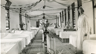 The Beechworth Burke Museum
Photograph, 1934
The photo is taken in 1934 and illustrates the internal view of a ward in the Mental Hospital at Beechworth. Some patients in beds and three nurses are in view. Beds were arranged in lines alongside the walls and there were no partitions or screens to create privacy for patients. Furniture was simple and humble; bed frames were made of metal or wood and pillowcases and covers for the attendant`s tables were sometimes made of blue-striped canvas or calico. Large windows in the walls were offering ample light and the room was well-tended, with Christmas decoration, flowers, pots and carpets on the floor. The nurse in the foreground is Miss Neary. The Mayday Hills Hospital was constructed between 1864 and 1867, with buildings created in a number of periods. It formally opened on 24 October 1867 and, along with the Ovens Hospital and the Benevolent Asylum, made Beechworth a prominent social welfare centre in Victoria. The need for an institution of this kind was arisen due to the increased number of people with mental disturbances (induced by the harsh living conditions on the goldfields) and the remoteness of the district from Melbourne. The site was chosen for its panoramic view of the countryside, the hilltop atmosphere and the native fauna, all contributing to the cure of patients. The Hospital was originally named the “Ovens Lunatic Asylum” but, during the centenary celebrations in 1967, the name was officially changed to “Mayday Hills Hospital”, showing the gradual shift in the perception and understanding of mental health conditions over the last decades. The Hospital lies on the traditional land of the Kulin Nation. This photograph is historically significant as it provides an insight into the living conditions of patients admitted to the Mayday Hills Hospital at the beginning of the 20th century. It also contributes to the understanding of the district`s development and its importance to the course of Victoria`s history. Additionally, it provides important information about the way mental health conditions were perceived at that time and how patients were treated. Black and white rectangular photograph printed on paper. Reverse: 1997.2665/ To Miss JA.Peach/ [hallmark: Printed by Harringtons]/ With best wishes/from/H.Jeanes/for 1934.mayday hills hospital, benevolent asylum, ovens hospital, ovens lunatic asylum, kulin nation, beechworth, patients, nurse, social welfare, goldfields, melbourne, mental health, living conditions, blue-striped canvas, calico, bed frames, miss neary, mental disturbances, traditional land, centenary celebrations -
 The Beechworth Burke Museum
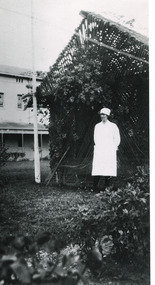
Photograph - Photograph Reproduction, 1998
The photograph, created in 1998, is a copy of the original one, depicting a nurse in uniform at the Mental Hospital in Beechworth, with a fern house behind her. In the background, the two-storey building is in view, along with the covered walkway. The institution had to operate with serious shortage of female nurses for long periods of time. During the 1880s, small houses (cottages) were built to offer accommodation for the nurses living in the hospital and in 1937 began the construction of a nurses` hostel. In 1962 the upper level of the Nurses` Home was converted into a Nurses` Training School. The Mayday Hills Hospital was constructed between 1864 and 1867, with buildings created in a number of periods. It formally opened on 24 October 1867 and, along with the Ovens Hospital and the Benevolent Asylum, made Beechworth a prominent social welfare centre in Victoria. The need for an institution of this kind was arisen due to the increased number of people with mental disturbances (induced by the harsh living conditions on the goldfields) and the remoteness of the district from Melbourne. The two-storey buildings, designed in Italianate style, and the three-storey towers at the front, were influenced by the asylum at Colney Hatch in England. Large masses of granite were excavated for its foundation and around 250 workmen were employed for its construction. The building, divided into six sections, was comprised of dormitories, doctors` rooms and plenty ancillary rooms and facilities, such as laundries, reading rooms, a concert hall and cooking areas. The site was chosen for its panoramic view of the countryside, the hilltop atmosphere and the native fauna, all contributing to the cure of patients. The Hospital was originally named the “Ovens Lunatic Asylum” but, during the centenary celebrations in 1967, the name was officially changed to “Mayday Hills Hospital”, showing the gradual shift in the perception and understanding of mental health conditions over the last decades. The Hospital lies on the traditional land of the Kulin Nation.This photograph is historically significant as it provides an insight into the everyday life of staff living within the walls of the Mayday Hills Hospital. It also offers important information about the location and the exterior of the Hospital and contributes to the understanding of the district`s development and its importance to the course of Victoria`s history.Black and white rectangular photograph printed on paper unframed.Reverse: 3445/mental hospital, beechworth, fern house, female nurses, nurses` home, nurses` training school, nurses` hostel, mayday hills hospital, ovens hospital, colney hatch, two-storey buildings, italianate style, benevolent asylum, ovens lunatic asylum, kulin nation, workmen, covered walkway, granite, hilltop atmosphere, mental health -
 The Beechworth Burke Museum
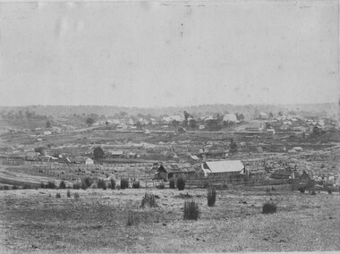
Photograph, 1865
Taken in Beechworth 1865, this photograph depicts the view of the Spring creek with the Beechworth township in the background. This photograph was taken 13 years after the discovery of Gold at Spring Creek. Within eleven months of the discovery in 1852, over 8000 hopeful prospectors had descended on the region, transforming the seemingly undisturbed land into what a visiting journalist in 1880s referred to as; "A Titan's Field". Huge mounds of earth were churned by hundreds of miners in search for gold, almost every available resource the land had to offer was used for something; even the bark off the gums were stripped to line huts and shafts. By 1857 more than 20,000 people lived in Beechworth, and with this influx the town prospered with the building of numerous churches, banks, schools, shops and hotels along with a prison and hospital.Black and white rectangular photograph. Image is printed on matte photographic paper and is mounted on cardboard.Obverse: NO INSCRIPTION Reverse: BMM6925 / BEECHWORTH FROM SPRING CREEK 1865 beechworth, spring creek, gold rush, titan's field, 1865, prospectors