Showing 123798 items matching "main-road"
-
 Whitehorse Historical Society Inc.
Document - Notes from Trove, Sampson Murder, Jan 1928, 1928
Notes from the State Library's Trove collection on the murder of Iolene Sampson 28 years old on 3 Jan 1928 at quarry Road Mitcham and the subsequent court case on 22 Feb 1928.Iolene Sampson had been married to Ted Sampson for 15 months and they were orchardists near the corner of Quarry and Mitcham Roads. The Kleinert's had an orchard across the lane from them. Ernest Ambrose Kleinert, 20 years old, was tried for the murder of Iolene Simpson but was acquitted. The murder was never solved.kleinert ernest ambrose, , sampson mary iolene, sampson edward augustus -
 Clunes Museum
Newspaper - NEWSPAPER CUTTING, Nov 1980
THIS NEWSPAPER/CUTTING FROM NOV. 1980 WAS COLLECTED BY THE LATE MRS. LENA WATTLEWORTH. IT IS BELIEVED TO SHOW THE FIRST HOUSE BUILD ALONG THE CRESWICK ROAD, WHICH WAS BUILD BY MISS BREDA TREMBATH'S GRANDFATHER MR GEORGE PERRY.NEWSPAPER CUTTING OF GEORGE PERRY'S GENERAL PRODUCE STORE AND RESIDENCE. November 1980. Citizen Award winner Brenda Trembath of Clunes has kindly allowed us to use this photograph of what is believed to be the first house built along the Creswick Road. It was built by Brenda's grandfather, George Perry.local history, document, newspaper cutting, trembath, perry -
 Rutherglen Historical Society
Photograph - Image, 1970s
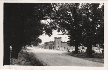
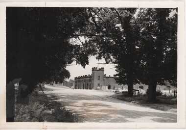
All Saints Estate is a family owned winery established in 1864 and located on the banks of the Murray River in Wahgunyah, North East Victoria. Original owners George Sutherland Smith, and John Banks, arrived from Caithness, Scotland in 1852. They were just 23 and 20 years of age. Choosing to settle in the Wahgunyah area, they used their training as engineers from the Edinburgh Railway Institute to build a bridge over the Edwards River at Deniliquin. They were also involved in the construction of several buildings in Beechworth including the Presbyterian Church, part of the Gaol and the original hospital of which the granite facade still remains today. Smith and Banks began growing vines at ‘Sunday Creek’ closer to Wahgunyah than the present All Saints Estate winery, before relocating to build the 'All Saints castle' just three miles north of Wahgunyah, in 1864. The partners took up 100 acres and proceeded with planting vines in earnest whilst also constructing pise cellars made from the estate soil. The All Saints Estate castle was based on the design of ‘The Castle of Mey’, including turrets and a tower. The castle was constructed mainly of handmade bricks that were fired in the All Saints Estate Brick Kiln (classified on the Victorian Heritage Register) on the property. However, only the battement parapets of the lower wall and a turrets were copied, not the main castle style. The Castle of Mey, most recently owned by the late Queen Mother, was where George Sutherland-Smiths’ father was a carpenter and joiner.Black and white photograph showing a view, up a road between the Elm Tree entry drive of All Saints Winery wineries, north east victoria, wine industry, all saints winery, rutherglen, wahgunyah, winemaking, castle, winery -
 Rutherglen Historical Society
Image, 1970s
All Saints Estate is a family owned winery established in 1864 and located on the banks of the Murray River in Wahgunyah, North East Victoria. Original owners George Sutherland Smith, and John Banks, arrived from Caithness, Scotland in 1852. They were just 23 and 20 years of age. Choosing to settle in the Wahgunyah area, they used their training as engineers from the Edinburgh Railway Institute to build a bridge over the Edwards River at Deniliquin. They were also involved in the construction of several buildings in Beechworth including the Presbyterian Church, part of the Gaol and the original hospital of which the granite facade still remains today. Smith and Banks began growing vines at ‘Sunday Creek’ closer to Wahgunyah than the present All Saints Estate winery, before relocating to build the 'All Saints castle' just three miles north of Wahgunyah, in 1864. The partners took up 100 acres and proceeded with planting vines in earnest whilst also constructing pise cellars made from the estate soil. The All Saints Estate castle was based on the design of ‘The Castle of Mey’, including turrets and a tower. The castle was constructed mainly of handmade bricks that were fired in the All Saints Estate Brick Kiln (classified on the Victorian Heritage Register) on the property. However, only the battement parapets of the lower wall and a turrets were copied, not the main castle style. The Castle of Mey, most recently owned by the late Queen Mother, was where George Sutherland-Smiths’ father was a carpenter and joiner.Black and white photograph showing a view, up a road between the Elm Tree entry drive of All Saints Winery On back of photo: "250% [upper case D in small circle] All Saints"wineries, north east victoria, wine industry, all saints winery, rutherglen, wahgunyah, winemaking, castle, winery -
 Whitehorse Historical Society Inc.
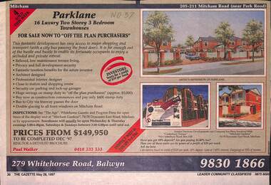
Newspaper - Advertisement, Parklane, 1/05/1997
Cutting of advertisement for Parklane '16 luxury two storey, 3 bedroom townhouses' at 205 Mitcham Road, (near Park Road). Agent Paul walker. Colour drawing. Also photographs of Canterbury Terrace, 910 Canterbury Road, Box Hill and Mitcham Gardens, Doncaster East Road, Mitcham. In Nunawading Gazette, 28th May, 1997parklane;, mitcham road, mitcham, residential development -
 Surrey Hills Historical Society Collection
Photograph, Streetscape near the corner of Victoria Crescent and Hotham Street, Surrey Hills
Prior to subdivision for housing this area was paddocks used for grazing of cattle and used as part of the course in the early days of the Surrey Hills Golf Club. Reproduced by permission of Mr John Arnold from his book: "The Riversdale Golf Club - a history, 1892-1977." Copyright to book: Riversdale Golf Club. Surrey Hills Golf Club operated from 1892-1908 then moved and became Riversdale Golf Club. The game was played across paddocks from Trafalgar Street, Mont Albert to Whitehorse Road and down Victoria Crescent to where Box Hill TAFE is now located in Elgar Road. There were problems with cows eating the tee flags! The clubhouse still exists as 30 Trafalgar Street.Black and white photo taken from the centre of a bitumen road which is flanked by bluestone guttering. Nature strips, drive cross-overs and house fences are shown. Trees on the RHS nature strip are pollarded to avoid overhead power and telephone lines. There houses in the background."Bottom: The same view today taken from the intersection of Victoria Crescent and Hotham Street, Surrey Hills."surrey hills golf club, hotham street, victoria crescent, riversdale golf club, surrey hills, john arnold -
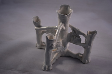 Warrnambool and District Historical Society Inc.
Household, Vase, Early 20th century
This vase would have been used to hold five small flowers or fronds and would have been a decorative item on a dining table or mantelpiece. Today a vase holding one or a small number of flowers is called a specimen vase and the style of these tends to be less decorative than the item described here. This item has no known local provenance but is retained as an example of a household item from the past.This is a white china vase with a central pillar representing the trunk of a tree and (originally) four pillars branching out from the main pillar to represent the branches of a tree. One of these pillars is now missing. The china stems holding the branch columns have embossed flowers and fronds. The main pillar and the branch pillars have irregular-shaped openings for flower insertion.household items, history of warrnambool -
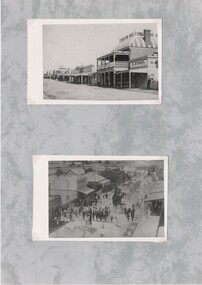 Rutherglen Historical Society
Post Card, 1890s
Two black and white photographs of old postcards, mounted on a sheet of decorative grey paper. Top one is of Main Street, Rutherglen, looking East, featuring the Cumberland Hotel and S. Stones, Baker and Confectioner. Bottom one shows a parade in Main Street, being led by the members of the Australian Natives Association, celebrating the passing of the Australian Federation legislation.main street, ana, australian natives association, australian federation, cumberland hotel, bakery, stones family -
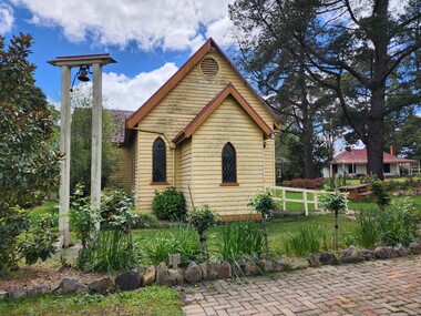 Old Gippstown
Building - Church
A small timber church, containing an entrance area, congregation area, vestry and a small store room. The main part of the church is rectangular, but the smaller rooms give the building a 'T' shape. The roof is 'A' framed and is corrugated iron. There are three crosses on the roof; one on the entrance and two on the main building; one on the front and one at the rear. There is a bell in the yard. Built in 1895moe, church, old gippstown, west gippsland, gippsland, gippsland heritage park, goldfields, coal mine, victorian era, historical village, church of england, holy trinity anglican church, rev. c.j. chambers, latrobe valley, old gippsland heritage park, latrobe city council -
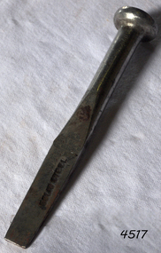 Flagstaff Hill Maritime Museum and Village
Tool - Caulking Tool, Ward & Payne Ltd, Late 19th century
Caulking is the traditional technique used on wooden vessels built with butted or clinker-built planks to fill the gaps between these planks while still allowing the wood to flex and move. This involved driving the irons, hammered in with the mallet, deep into the seams to open them up. After this, spun yarn, oakum (hemp) or cotton was driven deep into the gaps. The hemp or cotton was soaked in creosote or pine tar to make the joins watertight. Caulking also played a structural role in tightening up the hull or deck by reducing the longitudinal movement of the neighbouring planks. The subject item was made by Ward & Payne of the Limbrick Works at Hillsborough, Sheffield England manufacturers of hand-forged tools. Their trademark registered in 1850 was a Letter "W" & "P" stamped into the steel. The firm was established by David Ward (1767-1822) in 1803 the company became David Ward & Sons, in 1837 after Ward's son Edward joined the firm. In 1845 Henry Payne the founder's son-in-law became a partner but died in 1850 after which the company reverted to the Ward family. The business then concentrated on making carving tools, chisels and gouges. In 1882 David Ward's grandson David Ward Jr. (1835-1889) purchased land and built a factory at Sheffield North known as the "Limerick Wheel". For a time Wards operated from both 106-114 West Street Sheffield and at Limbrick Road, Hillsborough on the river Loxley. By 1911 they had expanded into making spades, forks, sheep shears and many other types of edged tools including drills and wood planes. In 1967 Wilkinson Sword purchased all the company's share capital and continued to sell Ward & Payne tools until 1970 when a fire burned the factory down and housing development was built on the site. The subject item is significant as it gives a snapshot of the technological development of sailing ships and their operation before steam-powered vessels took over around the world. Tools such as the subject item demonstrate the traditional craftsmanship and skill of the shipwright and the aesthetic quality of the timber ships designs of the time. Caulking tool with square end"WARD Sheffield"flagstaff hill, warrnambool, flagstaff hill maritime museum, shipwreck coast, flagstaff hill maritime village, james s steele, caulking iron, caulking tool, shipwright tools, ward & payne sheffield, forged tools -
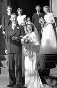 Surrey Hills Historical Society Collection
Work on paper - Photograph, Margaret Black's wedding 1st May 1948, 1948
Margaret Johnson was born and raised in the country. She came to Melbourne to attend secondary school at age eleven. She stayed with the family of her uncle, Dr Carrington, in their home / surgery still located at 174 Union Road, the Surrey Hills Medical Centre. Later, whilst waiting to commence her kindergarten training course, she met Jessie Black and they became firm friends and it was through Jessie that Margaret met Jessie’s brother and her future husband, Thorby Black. The Black family had been residents of Mont Albert for many years and Thorby was in the air force at the time. Margaret and Thorby were married at St Stephens Presbyterian Church in Surrey Hills on 1 May 1948. Her wedding dress was bought at Canns on the corner of Elizabeth Street & Flinders Lane. It was one in an exhibition held as part of a Surrey Hills Festival in the early 2000's. Like others in the exhibition, it no longer had its train and the sleeves have been shortened. Margaret recalled that after her wedding she wore it as an evening dress. Her bridesmaids’ dresses were a little unusual for the time, as they too were white and their flowers were subdued pink and blue. According to Margaret, the popular fashion was for brightly coloured dresses and bright flowers for the bridesmaids. The positioning of the garlands of flowers in their hair was also unusual. They were placed at the back so that the congregation could see them during the ceremony. Housing was in very short supply in the years following the war, so after they were married, Margaret and Thorby moved into a small flat created at Dr Carrington’s surgery. They later moved to a house built in 1926 in Black Street, Mont Albert, which continued to be Margaret’s home until her death. weddings, mrs margaret black, miss margaret johnson, mr thorby black, st stephens presbyterian church, bridal wear -
 Greensborough Historical Society
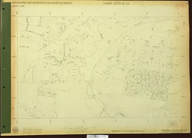
Map, Melbourne and Metropolitan Board of Works. Survey Division, MMBW, Yarra 2500 / 15.23. Diamond Creek Reserve, 1978_02
Melbourne and Metropolitan Board of Works. Yarra 2500 [base map] 15.23. Hurstbridge. Municipality of Diamond Valley 257. Prominent streets include: Challenger Street, James Cook Drive and Ryans Road / Main Street. Features include the Diamond Creek and Diamond Creek Reserve.MMBW Map in 1:2500 [scale] series. Cream parchment with green tape reinforcing on edges and punched holes on left edge.mmbw, melbourne and metropolitan board of works, shire of diamond valley, diamond creek - maps -
 Eltham District Historical Society Inc
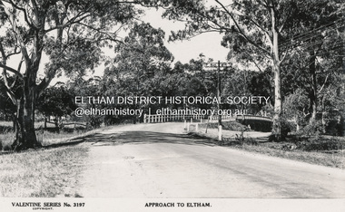
Postcard - Photograph postcard, The Rose Stereograph Company, Approach to Eltham, c.1939
Looking east along the unsealed main road heading into Eltham across the concrete bridge over the Diamond Creek circa 1939. The original wooden bridge was destroyed by flood waters in 1924. Valentine Series No. 3197 Postcard (Michael Aitkin Collection) dated Christmas 1943Postcard Digital file only Postcards scanned from the collection of Michael Aitken on loan to EDHS, 13 Feb 2018Valentine Series No. 3197bridge, diamond creek (creek), eltham, eltham south, main road, main road bridge, postcard, valentine series postcard, michael aitken collection -
 Eltham District Historical Society Inc
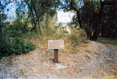
Photograph, Time Capsule Memorial Plaque designed by Joh Ebeli, Eltham Community Centre
Plaque describing monument at corner of Main Road and Pitt Street, Eltham, unveiled by Joh Ebeli, 10 October, 1987, the gift of Mr and Mrs R.C. McLellan. The commemorative plaque explains the functions of the various items used in the Victorian 150th Anniversary Monument and Time capsule.Colour photograph150th anniversary monument, 20th anniversary, eltham community centre, shire of eltham historical society, time capsule -
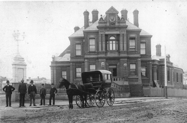 Kew Historical Society Inc
Photograph, Kew Post Office, c.1888
A copy of the earliest known photograph of the former Kew Post Office on the corner of Cotham Road and High Street, Kew. The Post Office was opened in 1888. The original architectural drawings are held at the Public Record Office Victoria.The photograph is significant as the earliest known image of this Heritage Victoria designated historic building.The Kew Post Office on the corner of High Street and Cotham Road, Kew. The photograph includes the Queen Victoria Jubilee fountain at left. The image predates the large fig tree planted on the corner and the later Kew War Memorial (1925). What are presumed to be government employees stand beside the horse and buggy. -
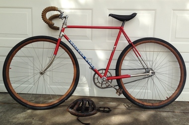 Geelong Cycling Club
Road Bike, 1929
Track cycle won by Jack Phillips 1929 in the Melbourne - Ballarat - Geelong - Melbourne Road Race. This was the first open road race won by a Geelong Amateur Cyclist. The Amateur Cycling Club was formed in 1929. This bike was restored by Ken Dickie who did his apprenticeship in fine line restorations and the painting was by Fred Cook. Hand grips by Harry Clarke. They used photographs from Jack Phillips of the original bike to restore the bike to its original colours and appearance.Track cycle one by Jack Phillips - the first of the big open road races won by an amateur.Restored Malvern Start Road Bike from 1929. Painted in red with the words Malvern Star highlighted in white on a blue background on the frame. The stem features two silver stars on a blue background. Single speed with wooden wheel rims. It has a leather saddle and rubber hand grips (formerly used as gas masks in WWI)"Malvern Star"jack phillips; geelong amateur cycling club; malvern star; geelong cycling club; 1929; -
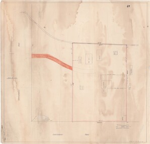 Ringwood and District Historical Society
Map - Ringwood Animal Welfare Clinic, 1958 Land Survey Drawing, Ringwood, Victoria
Plan of driveway and property east of Heatherdale Road and Canterbury Road corner, with details of house, shed, bungalow, dog pen, kennels and enclosures.Survey by H.L.M. 31-7-58. Scale 20'=1" -
 Phillip Island and District Historical Society Inc.
Newspaper clippings, 05/10/1967
Collection of newspaper clippers in scrap book dated 1960 - 1973Newspaper article concerning the renaming of Cemetery Road as Coghlan Road in honour of Eliza Coghlan, an early pioneer; her grave to be given a facelift."113-y.o to be honored"local history, newspapers, cemetery road to be renamed coghlan road, cowes phillip island, miss eliza coghlan, jean jamieson -
Glenelg Shire Council Cultural Collection
Photograph - Photograph - Cape Grant Quarry, 27/08/1953
Port of Portland Authority ArchivesBack: Purple PHT stampport of portland archives, cape grant quarry -
Glenelg Shire Council Cultural Collection
Photograph - Photograph - Rural Scene, n.d
Sourced from Casterton Town Hall (Former Shire of Glenelg)Black and white photo. Man from 7212 on side of road with small black and white dog. Car from 7211, 7212 on road. -
Glenelg Shire Council Cultural Collection
Photograph - Photograph - Cape Grant Quarry, 09/07/1954
Port of Portland Authority ArchivesBack: Purple PHT stampport of portland archives, cape grant quarry -
Port Melbourne Historical & Preservation Society
Photograph - Williamstown 'Short Road' ferry (punt) crossing the Yarra River, 1950s
copied from a photograph held by the City of Port PhillipLaser copy of photograph of the Williamstown 'Short Road' ferry (punt) crossing the Yarra River from Newport to Port Melbourne's Williamstown Road.transport - ferries -
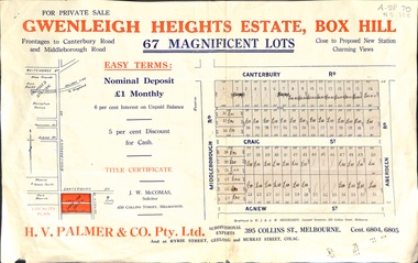 Whitehorse Historical Society Inc.
Document, Gwenleigh Heights Estate, Box Hill, unknown
Land plan of 67 allotments for sale between Canterbury Road, Middleborough Road and Agnew Street, Box Hill. (Now Blackburn South)land subdivision, middleborough road, blackburn south, canterbury road, agnew street, aberdeen road, h. v. palmer (estate agent) -
 Whitehorse Historical Society Inc.
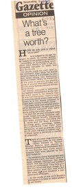
Article, What's a tree worth, 1990
Article in Nunawading Gazette about the probable axing of thousands of trees and shrubs along Springvale and Whitehorse Roads because of proposed widening of the roads.nunawading, trees, whitehorse road, springvale road -
 Whitehorse Historical Society Inc.
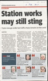
Article, Blackburn Level Crossing, 2017
Trains now travel under Blackburn Road but further construction work could require further closures to Blackburn Road later this year.level crossing removal authority, blackburn, blackburn road -
 Whitehorse Historical Society Inc.
Photograph, Mrs Jenning's Sweet Shop, C.1950s
Black and white photo of Mrs Jenning's Sweet Shop in group shops on west side of Boronia Road and south of Canterbury Road, Vermont.jennings, mrs., sweet shops -
 Whitehorse Historical Society Inc.
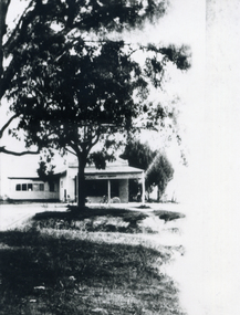
Photograph, Mirama Court, Mitcham, 2000
Coloured photograph looking toward Mirama Court from the Mitcham Road, Whitehorse Road intersection. Building being renovated for other users.mirama court, mitcham -
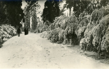 Mt Dandenong & District Historical Society Inc.
Photograph, Snow South of Quamby Cafe, c1921
Three people walking along snow covered road south of Quamby Café in Olinda. c1921. Snow laden bushes line the road.Written on back in pen: Snow scene Olinda 1921 or earlier. South of Quamby.snow, olinda, road, quamby -
Canterbury History Group
Photograph - Olsen"s Garage, 1920s
Olsens Garage in Rochester Road, just around the corner from Canterbury Road. Copied from a black and white photograph taken in the 1920s.canterbury, rochester road, petrol stations, vintage cars, fire hydrants, olsen> f.l., petrol pumps, iverson> family, smith> ivan -
Canterbury History Group
Document - School Project: Heritages sites of Maling Road, Mohandoss, Priya, 2011
Project on Maling Road by tertiary student Priya Mohandoss.Includes six black and white photographs taken by Miss Mohandoss in Maling Road in 2011.canterbury, maling road, canterbury mansions, canterbury post office, stationmasters house, maling road antique market, canterbury theatre