Showing 148 items
matching auction lots
-
 Bacchus Marsh & District Historical Society
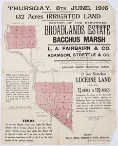
Map - Land Sales Plan, Broadlands Estate, Bacchus Marsh, 1916
... for an auction of part of a property near Bacchus Marsh known... of irrigated land in 11 separate lots was to be auctioned on the 8th ...This land sales map was produced by real estate agents for an auction of part of a property near Bacchus Marsh known as the Broadlands Estate. 132 acres of irrigated land in 11 separate lots was to be auctioned on the 8th of June 1916. On the 27 May 1916, nine of the 11 eleven lots were withdrawn from sale. The reason stated was due to "road and severance difficulties", according to a notice in the Bacchus Marsh Express newspaper on 27 May, 1916, page.2. When the sale took place on 8th June the two lots were passed in but the local newspaper reported they were expected to be sold privately, see Express, 17 June, 1916, page. 2. The Broadlands Estate was owned by the Miller family whose father Henry Miller, 1809-1888, was a politician and an immensely wealthy financier in Victoria.A typical example of a land sale map of this era. The Broadlands Estate was just over 2,000 acres at its its peak size and was a significant holding of land in the Bacchus Marsh district. Paper printed land sales mapbroadlands estate bacchus marsh, land sales bacchus marsh, farms bacchus marsh, henry miller 1809-1888 -
 Bendigo Historical Society Inc.
Document - LANDS OFFICE, CROWN LOTS SURVEYED AND SOLD IN THE SANDHURST DISTRICT 1857 - 1905, 1857 - 1914
Document: blue hard cover journal with buff spine and corners. (spine in poor condition, frayed and pieces missing) Contains details of crown lands surveyed and sold in Sandhurst district. LH page: town, suburban or country lands. RH page: auction, selection, price per acre, price overall and purchaser. Indexed by parish inside front cover. On spine ' Index book' ' Lands and Survey' '07' written on spine under damaged spine cover. Dated from 26/6/1857 to 24 February 1914Lands Officeland sales, lands office, land surveyed, land sold, bendigo, sandhurst -
![Map, Liquidator's sale, 1896. [Woolpack Estate, Bacchus Marsh]](/media/collectors/5e461d8021ea67224c82f2a1/items/6779ee97032b72846b5995f2/item-media/6779ef33032b72846b599b30/item-fit-380x285.jpg) Bacchus Marsh & District Historical Society
Bacchus Marsh & District Historical SocietyMap, Liquidator's sale, 1896. [Woolpack Estate, Bacchus Marsh]
... in lots by public auction. A successful sale was held on 24 June... in lots by public auction. A successful sale was held on 24 June ...The Woolpack Estate was an area of land owned by various landowners in the Bacchus Marsh area since the early Colonial period of the 1840s. The area was located on the eastern side of the Bacchus Marsh township about 7 kilometers from the town. The Lerderderg River ran through part of the land and so did the Melbourne to Ballarat Road. The historic Woolpack Inn associated with James Crook was also located on this land. By 1896 150 acres of this land was under the control of liquidators for the Federal Bank of Australasia who instructed that the land be sub-divided and sold in lots by public auction. A successful sale was held on 24 June 1896. Most of the blocks of land were sold for higher than expected prices and most of the buyers were people from the town and district of Bacchus Marsh. The map includes various details about the land which is described on the map as an "important sale of rich alluvial irrigable flat land in the Bacchus Marsh Valley, and other properties". The auction was conducted by the local agents W. Anderson and Bence in conjunction with Pearce Brothers also of Bacchus Marsh.A single page paper map showing a plan of 150 acres of land from the Woolpack Estate to be sold in various lots in June 1896. Also shown on the map are lots for sale at Robinson's Farm on Coimadai Creek and allotments near Bacchus Marsh railway station, including lots on Government Road (East Maddingley Road), View Street and Government Road (Parwan Road). No scale provided. The map is pasted into a bound volume containing 76 maps or plans in total. High resolution digital image stored on BMDHS computer network. land sales bacchus marsh, bacchus marsh victoria maps, woolpack estate bacchus marsh victoria -
 Bacchus Marsh & District Historical Society
Map, Pentland Hills Estate Land Sale 1904
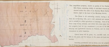
The Pentland Hills Estate property shown in this auction plan was put up for sale in 1904. It was a deceased estate sale. The property had been owned by Peter Grant who died in 1899. Peter Grant had worked and farmed in the Myrniong area for many years and had also been a Councillor on the Bacchus Marsh Shire for a number of terms. A property sales report in the Express newspaper recorded that the land for sale comprised 500 acres of the old Pentland Hills Estate. It was subdivided into three lots, all of which were sold at good prices. Lot l, 212 acres was sold to Messrs Thomas and Robert Lidgett of Myrniong, at £11/15/ per acre, lot 2, 200 acres, to Mr David Robertson, of Bacchus Marsh, at £9 17/0 per acre, and lot 3, 38 acres, was sold to Mr James Norton, jun at £11 per acre. A single page paper map showing a portions of land available for sale from the Pentland Hills Estate near Bacchus Marsh.The name of the seller, Mrs Grant, can seen handwritten on this map and the buyers of the three portions for sale, Lidgett lot 1, Robertson lot 2 and Morton lot 3. Parts of the text are missing along the edges due to tearing or excessive trimming of the edges. The map is pasted into a bound volume containing 76 maps or plans in total. High resolution digital image stored on BMDHS computer network. Handwritten: Mrs Grant, Myrniong, Executrix in the deceased Estate of Mr. Peter Grant to sell by public auction.land sales, pentland hills maps, myrniong area land sales, pentland hills estate -
 Ringwood and District Historical Society
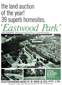
Document - Folder, Eastwood Park Subdivision, Ringwood East, Vic. - Land Sale Circa 1967 - Site of former Eastwood/Eastfield Golf Course
Subdivision is advertised as including homesites on former Eastwood Golf Course fairways and land contours.Collection of subdivision maps, and double-sided advertisement for auction sale on Saturday, April 22nd, 1967, with summary of local features and services. Subdivision includes Croydon South streets, Andrew Crescent and Banksia Court. Agents - N.R. Reid & Co Pty Ltd, 173 Coleman Parade, Glen Waverley, Tel. 560 0355 A.H. 232 8423.Handwritten sales notations include "Vendor - Willcroft Development P/L 54-60 Southern Road Mentone Tel 93-1267 (Mrs. Morley). Lot 19 $5200, Lot 25 $4500, Lot 28 $3800, Lot 29 $3700, Lot 30 $3600. $400 deposit balance 3 yrs @ 7% $40 per month. All C/S to be prepared by vendor. 5% discount for cash." -
 Ringwood and District Historical Society
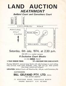
Flyer - Land Auction, Carruthers Estate, Heathmont, Victoria - 1974
Double-sided page advertising auction of 11 allotments on Saturday, 6th July, 1974, with locality map and plan of subdivision in Carruthers Court and Bellbird Court, Heathmont. $950 deposit, 3 year vendor terms, 10% discount for cash 60 days. Handwritten notation indicating Lot 22 "sold for $127,000 - all other lots passed in around $11,000".Auctioneers - Bill Gelfand Pty. Ltd., R.E.S.I. 71 Kooyong Road, Caulfield North, Phone 5090211 A.H. 523050. -
 Bendigo Historical Society Inc.
Document - LANDS OFFICE: SALE OF CROWN LANDS BY PUBLIC AUCTION, 25/5/1898 - 26/8/1915
Journal: green hard cover journal with brown spine and corners. LH page: lot, county, town or parish, section, allotment, extent, why not sold, upset price per acre, sold for per acre. RH page: value of improvements, name of purchaser, residence, deposit forfeited, total amount. Contains details of sales by public auction across Victoria.Lands Officecrown lands public auction, lands office, crown lands, public auction., sandhurst -
 Bendigo Historical Society Inc.
Document - LANDS OFFICE - SALE OF CROWN LAND BY AUCTION, 1892 - 1920
Document: dark green hard cover journal with buff spine and corners. Contains details of public auctions of crown lands in fee simple at various locations in northern Victoria. Printed details of auctions pasted for each sale. LH page: lot, county, parish, section, allotment, sold, unsold, why not sold, upset price, sold for. RH page: value of improvements if any, name of purchaser, residence, deposit forfeited, total amount.Lands Officelands office, crown lands, auction, northern victoria -
 Ringwood and District Historical Society
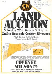
Flyer, Land Auction, Rosedale Crescent, Ringwood East - 1976
Single page advertisement for auction of 7 residential blocks in Rosedale Crescent, Ringwood on 22nd May, 1976.Vendor Terms $1,500 deposit. Agent - Covey Wilson Pty Ltd., Ashley House, 409 St.Kilda Road, Melbourne. Phone 2674022 AH 805062, 7892533. Handwritten notation "LP 97896 Vol 9038 Fol 283, seven available lots 9, 10, 11, 12. Other lots on request Res C." Lot 1 Council Reserve. Lot 2 PI 16750. Lot 7 PI 13250. Lot 8 PI 13350. Lot 9 PI 13500. Lot 11 PI 12750. Lot 12 Sold 13500(?). -
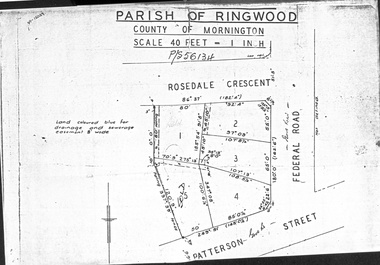 Ringwood and District Historical Society
Document - Folder, Map of Subdivision for auction - Ringwood East, Vic., 1973
... by Richard Carter - Carter Real Estate - "5 lots (heavily filled... by Richard Carter - Carter Real Estate - "5 lots (heavily filled ...Photocopy of Parish Map showing five residential blocks for sale on Rosedale Crescent, Federal Road and Patterson Street Ringwood East.Accompanying handwritten sales notes researched in 2024 by Richard Carter - Carter Real Estate - "5 lots (heavily filled) auction 14 July 1973. All later sold $4000 each - unknown agent". -
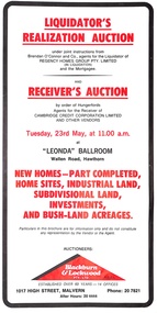 Ringwood and District Historical Society
Pamphlet, Liquidator's and Receiver's Auction, Highland Boulevard, Ringwood, Victoria, and other locations - Circa 1980
Multi-fold brochure with Order of Sale list of home sites, industrial land, subdivisional land and bushland acreages being auctioned at "Leonda" Ballroom, Hawthorn, Vic., Tuesday 23rd May (year not documented, circa 1980). Brochure includes 8 homesites with handwritten sales notations for Lots 94, 99, 100, 102, 104 and 105 Highland Boulevard, Ringwood at 11.30a.m., and at 11.45a.m., 3 completed homes at Lots 86, 88 and 89 & 5 near-completed homes Lots 74, 75, 76, 77 and 79 Highland Boulevard. Auctioneers - Blackburn & Lockwood Pty Ltd., 1017 High Street, Malvern, Phone 207821 After Hours 20 4444.Liquidator's Realization Auction under joint instructions from Brendan O'Connor and Co., agents for the Liquidator of Regency Homes Group Pty. Limited (in Liquidation) and the Mortgagee. Receiver's Auction by order of Hungerfords, Agents for the Receiver of Cambridge Credit Corporation Limited and other vendors. Order of Sale property locations include Mulgrave, Ringwood, Doncaster, Portartlington, Geelong, Altona, Mooroolbark, Scoresby, Gembrook, Maidstone, Port Melbourne, Laverton, Werribee, Werribee North, and Sunshine. -
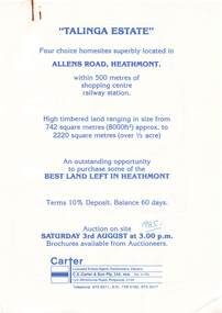 Ringwood and District Historical Society
Flyer, Land Auction Advertisement, Talinga Estate, Allens Road, Heathmont, Vic. - 1985
Double sided A4 page with subdivision map showing location and size of allotments for auction on Saturday 3rd August (1985). Agent - C.E. Carter & Son Pty. Ltd., 122 Whitehorse Road, Ringwood 3134, Telephone 870 6211.Handwritten sale price annotations - Lot 1 Sold $42,000, Lot 2 Sold $42,200, Lot 3 Sold $41,500, Lot 4 Sold $53,000. -
 Lakes Entrance Historical Society
Photograph, Lakes Post Newspaper, 1995
This image appeared in the Lakes Post Newspaper 6 September 1995Black and white photograph of a crowd of people looking over the lots up for bids at the auction of Vi Symmons property on Esplanade, situated in the retail area. Lakes Entrance Victoriatownship, retail trade, auction, people -
 Bendigo Historical Society Inc.
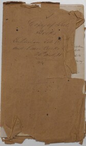
Document - LANDS OFFICE: SANDHURST AND DISTRICT LAND SALES BY PUBLIC AUCTION 1854
Document: booklet, heavy brown paper cover, written on cover ' copy of sale books, suburban lots in Sheep wash and Emu Creeks sold June 20th. And 21st. 1854. Contains newspaper cuttings with purchase amount and purchaser name. White sticker fixed to pocket: Book 2 Strathfieldsaye and Nerring Land Sales 20th. June 1854 to 21 June 1854lands office, bendigo, sandhurst, land sales, auctions -
 Bendigo Historical Society Inc.
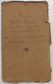
Document - LANDS OFFICE: SANDHURST CROWN LAND SOLD BY AUCTION 1854
Document: LANDS OFFICE: SANDHURST CROWN LAND SOLD BY AUCTION 1854 booklet - brown paper cover with blue pages. On front cover ' copy of sale books, town lots Sandhurst, April 18,19,20,21, 22 and 24 also suburban lots on the Bendigo Creek sold May 10TH.? 1854' Booklet contains copies of advertisement for auctions, written alongside, name of purchaser and amount paid per acre. White sticker fixed to pocket ' Book 1, Sandhurst Land Sales, 10 May 1854 to 18 May 1854Lands Officelands office, bendigo, sandhurst, land sales -
 Bendigo Historical Society Inc.
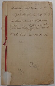
Document - LANDS OFFICE: SANDHURST AND DISTRICT LAND SALES BY PUBLIC AUCTION 1854
Document: booklet listing land sold by public auction in Sandhurst and surrounding district. Written on front page in black ink: ' Huntly September 19, Eaglehawk Sept. 21st & 22nd. Sandhurst Town Lots Oct. 21st. Ravenswood Oct 24th & 25th. Sandhurst Bendigo Creek Epsom Oct. 25th. White Hills Nov. 14, 15, 16. White sticker fixed to pocket: Book 3 Sandhurst Land Sales, including outlying areas 19 September 1854 to 13 December 1854.land sales, land office, sandhurst, bendigo, crown land sales -
 Bendigo Historical Society Inc.
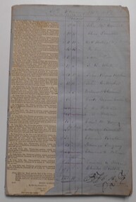
Document - LANDS OFFICE: SANDHURST AND DISTRICT LAND SALES BY PUBLIC AUCTION 1857, 1857 - 58
Document: blue lined pages listing crown land auctions held in Sandhurst 1857/58. Book contains newspaper cutting listing town lots for sale. LH page: Total, balance, deposit, purchaser. LH page: same. White sticker fixed to front: Book 6 Sandhurst land Sales including outlying areas 30 January 1857 to 29 June 1859bendigo, land sales -
 Bendigo Historical Society Inc.
Document - LANDS OFFICE: REPORTS OF LAND SALES BY AUCTION 1876 - 1891, 1876 - 1891
Document: green hard cover journal, buff spine and corners. Contains details of land sales by public auction Kerang, Swan Hill and Boort. m LH page ' Lot, County, Town or parish, section, allotment, sold, unsold, why not sold, upset price, sold per acre. RH page: value of improvements, name of purchaser, residence, deposit forfeited, total amount. On spine in gold lettering ' report of sales by auction' underneath 'land sales' in black. No. 6 on top of spine, letter K on base.Lands Officeland sales, kerang, swan hill, boort, sandhurst, lands office -
 Bendigo Historical Society Inc.
Document - LANDS OFFICE: REGISTER OF CROWN LAND LOTS SOLD BY PUBLIC AUCTION, 1951 - 1987
... LANDS OFFICE: REGISTER OF CROWN LAND LOTS SOLD BY PUBLIC... pages entered with details of sales by public auction of crown ...Document: hard cover journal, black cover with buff spine and edges. 89 pages entered with details of sales by public auction of crown lands. LH page: lot, county, town or parish, allotment, section, area, survey fee paid, upset price per lot, sold for per lot. RH page: value of improvements if any, name of purchaser, address, purchase money paid, grant fees and assurance paid.Lands Officeland sales, lands office, crown land, bendigo, kyneton, castlemaine, sea lake, girgarre, inglewood, echuca -
 Bendigo Historical Society Inc.
Document - LANDS OFFICE: SALE OF CROWN LANDS
Hard cover journal, green cover with buff spine and edges. Sticker on the front: Sale register 1934-1954. On the spine in red the number 16 and in black Land Sales 10-01-1934 to 31-12-1954. Pages entered with details of sales by public auction of crown lands. LH page: lot, county, town or parish, allotment, section, area, survey fee paid, upset price per lot, sold for per lot. RH page: value of improvements if any, name of purchaser, address, purchase money paid, grant fees and assurance paid.land sales, victoria, crown land sales, bendigo, central and northern victoria -
 Ringwood and District Historical Society
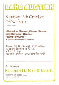
Document - Folder, Land Auction - Peacock's Estate, Waterloo Street, Heathmont, Victoria - 1973
Photocopy of Certificate of Title and double sided bi-fold leaflet advertising auction of 14 allotments on 13th October 1973 with map of streets, summary of local services and terms of sale. Subdivision includes Waterloo Street, Burns Road (later Dirkala Avenue), and Simpsons Road (later Simpsons Court). Auctioneers - C.E. Carter & Son R.E.S.I. 126 Whitehorse Road, Ringwood, Telephone 870 2519, 870 6830, 870 6024, A.H. 870 0421, 870 3568.Auctioneer's notation of sale prices included on brochure - all sold on day of auction. Vendor Frank Harry Peacock, Tile Burner, named as proprietor of Lot 12 on Plan of Subdivision No. 95654 on Title (Vol 8999 Fol 058). Map shows Dandenong Creek Watercourse as at September, 1971, prior to Dandenong Creek Trail development. -
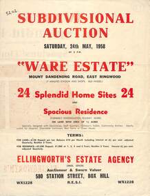 Ringwood and District Historical Society
Flyer, Subdivisional Auction Sale Brochure, Ware Estate, East Ringwood, Vic. - 1958
Folded double-sided advertisement for auction of 24 home sites and existing residence on Saturday, 24th May, 1958, including locality map, subdivision layout, terms of sale, and summary of local facilities and services. Additional plan of lots 28-33 dated 26/10/60 by Licensed Surveyor for Kirkpatrick & Webber, 225 Maroondah Highway Ringwood headed Plan of Subdivision of part of Crown Allotment 26A Parish of Ringwood.Subdivision includes Mount Dandenong Road, Ware Crescent, Davey Drive, and Grey Road (later Grey Street). Timber residence included in the subdivision was formerly Ware Kindergarten Holiday Home. (Agent) Ellingworth's Estate Agency, 580 Station Street, Box Hill - (Phone) WX1228. -
 Lakes Entrance Historical Society
Photograph - Johnsonville School, 1993
Johnsonville School Fair was held Melbourne Cup long weekend - November.Black and white photograph Auction and Fair day in grounds of primary school, lots of people mingling around, ladies with sun hats and shade umbrella. Johnsonville Victoriaschools, activities -
 Ringwood and District Historical Society
Document - Research Notes, Richard Carter, Land Subdivisions in Ringwood 1890-1950
Handwritten table listing main local pre-1950s subdivisions in the Ringwood area, with estate names, streets, number of allotments for sale, and where known, vendor agent, LP (Lodged Plan) title registration number, and auction/sale date, some with sale price.Pg1 RINGWOOD STATION ESTATE LP3070 (Year?) Station Street, William Street (now Kendall Street), Wantirna Road, Station Street Pg1 RINGWOOD TOWNSHIP ESTATE LP5577 (1913) Station Road (now Warrandyte Road), Pratt Street (part now Aird Street), Whitehorse Road Pg2 RINGWOOD ORCHARD ESTATE LP4315 (1914) Brysons Road, Hillcrest Road, Anzac Avenue, Sulva Road Pg3 RINGWOOD RAILWAY ESTATE LP7522 (1918) Whitehorse Road (now Mount Dandenong Road), Dublin Road, Freeman Street, Patterson Street, Bona Street Pg4 THE RINGWOOD ESTATE LP7578 (1919) Warrandyte Road, Hobart Street, Paxton Street, Arnold Street Pg5 GARDEN FARMS ESTATE (LP?) (1919) Canterbury Road, Armstrong Road, Bungalook Road, Orchard Road, Bayswater Road (now Mountain Highway) Pg6 THE RINGWOOD ESTATE (SECOND SUB-DIVISION) LP7604 (1919) Warrandyte Road, Tamar Street, Derwent Street, Mersey Street Pg7 RINGWOOD STATION ESTATE LP7703 (1919) Bedford Road, Williams Grove (now Lena Grove) Pg8 RINGWOOD TOWNSHIP ESTATE LP8198 (1919) Wantirna Road, Ellison Street, Haig Street, Greenwood Avenue Pg9 EASTFIELD ESTATE (LP?) (1920) Eastfield Road, Longview Road, Pleasant Rise, The Mount Pg10 ELECTRIC RAILWAY ESTATE RINGWOOD LP9473 (1922) Campbell Street, Myrtle Avenue, George Street (now Tudor Court), Henry Street (now Myrtle Avenue), Williams Grove (now Lena Grove) Pg11 RINGWOOD PARK ESTATE LP7884 (1922 - two stages) Wonga Road (now Loughnan Road), William Street, Andrew Street, Harrison Street Pg12 HEATHMONT STATION ESTATE LP11009 (Date? - after 1922) Lisgoold Street, Viviani Crescent, Balrour Avenue, Station Street (now part Heathmont Road and part Wainui Street) Pg13 RINGWOOD RAILWAY ESTATE LP10507 (1923) Whitehorse Road, Sherbrooke Avenue, Burwood Avenue, Bonview Avenue, Heatherbrae Avenue, Grant Crescent Pg14 GARDEN HOMES ESTATE (LP?) (1923) Mullum Road, The Centreway, Wattle Crescent (now Wattle Avenue) Reserve Crescent (now Reserve Road) Pg15 DUBLIN ROAD ESTATE LP11993 (1923) Alexandra Road, Vonadawn Avenue, Green Street, Wood Street, Howard Avenue, Bedford Road, Dublin Road Pg16 CARLINGA ESTATE RINGWOOD LP9620 (1923) Bourke Street, Bond Street, Ringwood Street Pg17 PRATT'S JUNCTION ESTATE (LP?) (1923) Junction Street, Georges Road, Oliver Street, Whitehorse Road Pg18 EAST RINGWOOD ESTATE LP10492 (1923) Bona Street, Patterson Street, Miller Grove, Fairview Avenue, Eastfield Road, Whitehorse Road (now Mount Dandenong Road) Pg19 COLEMAN'S HEATHMONT ESTATE LP9974 (1923) Canterbury Road, Bedford Road, Alvena Crescent, Coleman Street, Leonard Street (now Royal Avenue) Pg20 RINGWOOD HEIGHTS ESTATE LP10506 (1924) Whitehorse Road, Bonview Avenue, Grant Crescent, Hillcrest Avenue, Heatherbrae Avenue, Margaret Street, Mary Street Pg21 EAST RINGWOOD STATION ESTATE LP10551 (1924) Knaith Road, Wenwood Street, Lois Street, Victoria Street, Station Street (now Railway Avenue) Pg22 GRAND VIEW ESTATE LP11019 (1924) Whitehorse Road, Rupert Street, Herbert Street, Leonard Street Pg23 RINGWOOD RAILWAY ESTATE & RINGWOOD HEIGHTS ESTATE - FINAL SECTIONS LP10506 & LP10507 (1924) Whitehorse Road, Sherbrooke Avenue, Burwood Avenue, Bonview Avenue, Heatherbrae Avenue, Margaret Street, Mary Street, Grant Crescent Pg24 RINGWOOD EAST ELECTRIC STATION ESTATE (LP?) (1924) Railway Parade (now Patterrson Street), Federal Road, Howship Avenue (part now French Street), Dublin Road, Rosedale Crescent Pg25 BEDFORD PARK (now Ringwood Secondary College) (LP?) (1924) Bedford Road, Adams Street, Anderson Street, Joyce Street, Graham Road Pg26 CROWN JEWEL ESTATE LP11645 (Private sales after 1924) Mount Dandenong Road, Mirabel Avenue, Valda Avenue, Evon Avenue, Velma Grove Pg27 GRAND CENTRAL ESTATE LP10917 (1925) Heathmont Road, Great Ryrie Street, Douglas Street, Garden Street, Bellevue Avenue Pg28 RINGWOOD (unnamed estate - 1926) Nelson Street, Seymour Street, Whitehorse Road Pg29 EAST RINGWOOD RAILWAY STATION ESTATE (YEAR? - 25 shops 60 villas) Railway Avenue, Dublin Road, Lawrence Grove, Stanley Avenue, Knaith Road Pg30 CHARM VIEW ESTATE (LP?) (year? - after 1926) Canterbury Road, Heathmont Road, Dickasons Road, Bennjett Avenue, Orchid Street Pg31 SUNBEAM ESTATE LP12150 (Circa 1925) Govt Road (now Old Lilydale Road), Sunbeam Avenue, Holland Road, Everard Street (now Everard Road) Pg32 FAIRVIEW ESTATE EAST RINGWOOD LP10853 (Circa 1924) Eastfield Road, Patterson Street, Margaret Street (now Short Street) Pg33 EAST RINGWOOD TOWNSHIP ESTATE LP3025 (Circa 1924 - 35 allotments) Mount Dandenong Road, Grey Street, Eastfield Road Pg34 EAST RINGWOOD TOWNSHIP ESTATE LP3025 (Circa 1924 - 49 allotments) and STATE SCHOOL ESTATE (26 allotments) and EAST RINGWOOD STATION ESTATE (14 shop sites) Mount Dandenong Road, Grety Street, Dunn Street, Eastfield Road, King Street, Holland Road, Dublin Road, Patterson Street, Bona Street Pg35 EAST RINGWOOD CENTRAL ESTATE LP17004 (1948) Knaith Road, Shasta Avenue, Talofa Avenue, Russet Road, Dublin Road Pg36 WARE ESTATE LP43360 (1958) Ware Crescent, Davey Drive, Grey Road (now Grey Street), Mount Dandenong Road Pg37 Lot 57 Kendall Street LP3070 (1939) £75.0.0 Pg37 Lot 14 LP7346 (year?) £225 Pg37 Lot 8 WHITE HORSE ESTATE LP14010 (year?) Maroondah Hwy, Seymour Street £98.9.0 Pg37 Lots 4-14 incl. LP10902 (year?) £300 Pg37 Lots 69&70 LP2216 (1939) Bedford Road, Pitt Street £500 Pg37 Lots 60&70 LP2216 (year?) £460 Pg37 MOUNTAIN VIEW ESTATE LP10902 (1936) Lots 1&2, 19-22 Wantirna Road, Daisy Street £50 Pg38 RAILWAY STATION ESTATE RINGWOOD EAST LP7522 (1925) Lots 16 to 19 £250 Pg38 RINGWOOD PARK ESTATE (LP?) (1924) Lot 112 Munro Street £230 Pg38 RINGWOOD TOWNSHIP ESTATE (LP?) (1925) Lot 57 Wantirna Road £850 Pg38 ELECTRIC RAILWAY ESTATE LP9473 (1925) Lot 98 & 99 £180 (30/- foot) Pg38 ELECTRIC RAILWAY ESTATE LP9473 (year?) Lot 100 £233.12.6 incl improvements (£2.12.6 foot) Pg38 Lot 22&23 Bedford Road Heathmont (LP & year?) £675 incl improvements Pg39 Lot 9 Mullum Mullum Road LP8221 (1923) £150 Pg39 Lot 27 Haig Street LP8198 (1925) £825 Pg39 Lot 56 Haig Street cnr Wantirna Road LP8198 (1923) £171 Pg39 Lots 3 & 4 Loughnan Road LP9626 (192?) £147 Pg39 Lots 98 & 99 Myrtle Avenue LP9473 (1925) £180 Pg39 Lots 80 & 81 Myrtle Avenue LP9473 (1929) £150 Pg39 Lot 30 Sherbrooke Avenue LP10507 (1926) £700 incl improvements Pg40 Lot 10 (year?) LP7703 £750 Pg40 Lot 36 (year?) LP7522 £25 Pg40 Lot 38 Pitt Street LP2216 (year?) £350 Pg40 Lot 7 Dublin Road cnr Green Street LP11993 (year?) £300 -
 Ringwood and District Historical Society
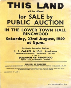
Poster, Land for Sale by Public Auction, Lower Town Hall, Ringwood - Saturday 22nd August, 1959
Yellow poster and smaller attachment with auction details and summary of four properties offered under Borough of Ringwood instructions for unpaid rates, some with handwritten monetary notations.Lot 49 Patterson Street, East Ringwood (Opp. station). Made Road, Water and E.L. 60'x220' approx. Lot 48 Stoda Street, Heathmont. Water and E.L. 50'x150'. Lot 86 Cnr Heatherbrae & Burwood Avenues, Ringwood. Made roads, Water and E.L. 54'x140' approx. Lot 13 Tagell Road Ringwood. 64'x1130' approx. For further particulars apply to C.E. Carter & Son, Auctioneer, Maroondah Highway, Ringwood (Phone) WU6042, WU6830, or Borough of Ringwood, Town Hall, Ringwood (Phone) WU6616. F.P. Dwerryhouse, Town Clerk. -
 Bendigo Historical Society Inc.
Document - NEW RED, WHITE & BLUE G. M. C. N. L - EXTRACTS ON AUCTION AT NEW RED, WHITE & BLUE G. M. C. N. L
Handwritten notes. Extracts - Auction Sale Wed. 23rd Nov. 1938 at the New Red, White & Blue G. M. C. N. L. Some lots were damaged by fire. Lots included: Extensive corrugated iron battery house, Mounting for 6 ft bull wheel, Stamper battery (No 1 Box) by Geo Kelly & Lewis, Stamper battery (No 2 Box) by Geo Kelly & Lewis, Stamper battery (No 3 and No 4 Boxes) Geo W Kelly & Lewis, Stamper battery (No 5 and No 6 Boxes) by Roberts & Sons, 144 H. P Twin Crude Oil Engine by Ruston & Hornsby Pty Ltd. Class H Size No 10. 84 H. P Twin Crude Oil Engine by Ruston & Hornsby Pty Ltd No 143379 Class H. C Size No 8.document, gold, new red, extracts on auction at new red, white & blue g. m. c. n. l, mining plant, geo kelly & lewis, roberts & sons, ruston & hornsby pty ltd -
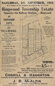 Ringwood and District Historical Society
Flyer, Auction Sale Advertisements - Ringwood Township Estate, Ringwood, Victoria - 1913
Advertisements for auction sale of retail and residential blocks opposite the Ringwood Railway Station on Saturday, 8th November, 1913, showing subdivision layout, terms of sale, and summary of local features and services. Auction at 3 o'clock on the property by order of Mr. O.J. Pratt - 18 township lots, 27 villa blocks, also weatherboard butcher's shop with 5-roomed weatherboard house and good stabling, and 5-roomed new weatherboard villa. Subdivision includes Station Road (later Warrandyte Road), Pratt Street, and Whitehorse Road. Agents - Coghill & Haughton, 79 Swanston Street, Melbourne, Auburn & Canterbury, in conjunction with J.B. McAlpin, Opposite Railway Station, Ringwood. Additional 2 partially trimmed copies allotment maps on cardboard backing with handwritten sales notations. -
 Hymettus Cottage & Garden Ballarat
Work on paper - Book, The English Women's Magazine
non-fictionjohn pascoe fawkner, melbourne, taffe fawkner collection, hymettus library, ballarat, kirsop, book collectors' society of australia