Showing 1406 items
matching bushfire
-
 Marysville & District Historical Society
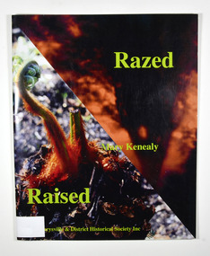
Book, Razed-Raised, 2013
The story of the regrowth of the Marysville community after the 2009 Black Saturday bushfirePaperback. Front cover has two colour photographs. One is a blurred photograph of a silhouette of a tree with fire behind it. The other is of a plant just starting to grow. Back cover has the symbol depicting Maryville's 150 anniversary in 2013. Stamp of Marysville & District / Historical Society Inc / P.O. Box 22 / Marysville 3779marysville, black saturday, bushfire, community, triangle community, regrowth -
 Marysville & District Historical Society
Book, Razed-Raised, 2013
The story of the regrowth of the Marysville community after the 2009 Black Saturday bushfirePaperback. Front cover has two colour photographs. One is a blurred photograph of a silhouette of a tree with fire behind it. The other is of a plant just starting to grow. Back cover has the symbol depicting Maryville's 150 anniversary in 2013. Stamp of Marysville & District / Historical Society Inc / P.O. Box 22 / Marysville 3779marysville, black saturday, bushfire, community, triangle community, regrowth -
 Forests Commission Retired Personnel Association (FCRPA)
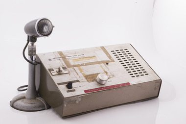
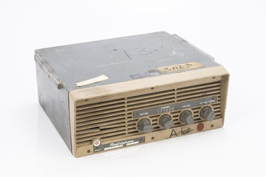
Base station radio with handset, Mid 1980s
After the 1939 bushfires, the Forests Commission invested heavily in a radically new communications network. After suffering some inevitable delays due to the War, radio VL3AA switched into full operation in October 1945 proudly beaming out 200 watts across the State. But by today’s standards, the technology was primitive and the reception poor unless the user was on a high point somewhere. The radio signal was "line-of-sight" and bounced between fire towers and relay transmitters across the mountains back to the District offices. The more secure and versatile State Mobile Radio (SMR) digital trunk system came into operation in about 1995. Upgraded Tait Radios were purchased in 2014 after recommendations of the 2009 Bushfires Royal Commission. But it was the convergence of separate technologies such as 4G mobile phones, high-capacity and light-weight lithium batteries, Wi-Fi, the ever-expanding internet, cloud data storage, digital cameras, GPS, personal organisers and hundreds of supporting Apps into powerful smartphones and tablets which revolutionised bushfire communications from the mid-2000s.Base station radio with handsetRC-4B Amalgamated Wireless Australiabushfire, radios, forests commission victoria (fcv) -
 Diamond Valley Vietnam Veterans Sub-Branch
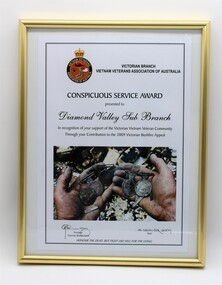
Certificate - VVAA (Vic), 18/12/2009
A record of gratitude for the Sub Branch's assistance to Vietnam veterans after the disastrous bushfires in 2009.Significant to have visible some simple evidence that the Vietnam veteran Sub Branches look after their own if they are experiencing difficulties,Famed Certificate, rectangular in shape in portrait profile, metal frame."Awarded by the Victorian Branch of the Vietnam Veterans Association of Australia to the Diamond Valley Sub Branch in recognition of your support of the Victorian Vietnam Veteran Community Through your Contribution to the 2009 Victorian Bushfire Appeal". Signed by the State President, Bob Elworthy, 18 December 2009. With the organisation's motto at the foot of the Certificate: "HONOUR THE DEAD BUT FIGHT LIKE HELL FOR THE LIVING"diamond valley vietnam veterans sub branch, vvaa (vic) -
 Eltham District Historical Society Inc
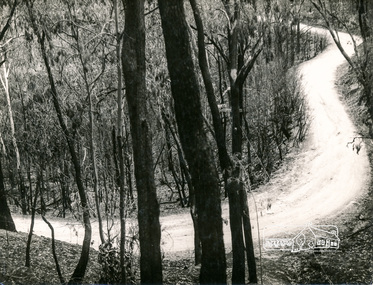
Photograph, George W. Bell, Eltham Laughing Waters Area, 1965
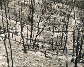
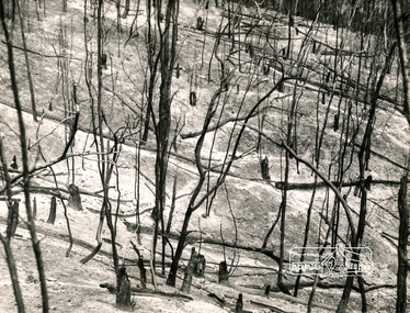
Black and white photograph of bushfire aftermath Laughing Waters Road Eltham 1965laughing waters road, eltham, fires, bush fires, george w bell collection -
 Eltham District Historical Society Inc
Photograph, George W. Bell, Fire Aftermath, Laughing Waters Area, 1965
Black and white photograph of bushfire aftermath Laughing Waters Road Eltham 1965.laughing waters road, eltham, fires, bush fires, george w bell collection -
 Department of Energy, Environment and Climate Action
Fire prevention gallows signs (six double sided signs with different messages on each side)
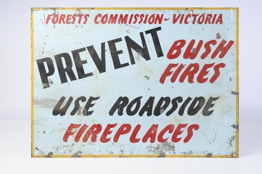
Bushfire awareness gallows signs were common features during the summer fire season and hung outside both FCV offices and on major roadways These six large metal signs have different text on each side and the message and lettering is simple enough to be read from a moving vehicle Metal Fire awareness gallows signsforests commission victoria (fcv), bushfire, forest signs -
Clunes Museum
Document - NEWSPAPER - CUTTING, The Sun newspaper, 1944 BUSHFIRES, 10/01/1944
1944 BUSHFIRES.1 ARTICLE THE SUN, 9/01/1944. BUSHFIRES BURNT 15 HOMES, HOSPITAL AT CLUNES .2 ARTICLE THE SUN, 10/01/1944. BUSHFIRES AT CLUNES .3 NEWSPAPER ARTICLE, PHOTOGRAPH OF CLUNES FIRE AFTERMATHbushfires, 1944 -
 Marysville & District Historical Society
Book, Murrindindi Shire Council, Beyond Age-From the ashes: portraits of resilience, love and loss, 2011
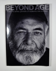
The devastating Victorian bushfires of February 2009 claimed the lives of 173 people. Since then, residents and property-owners throughout the Shire of Murrindindi have rallied together to reclaim their homes, their communities, their relationships and the landscapes they love. Many of them are senior citizens, who have demonstrated through their resilience, wisdom and sense of humour that age often means nothing more than numbers. From CFA volunteers to church-wardens, shearers to scone-makers, older members of the Shire of Murrindindi continue to play their parts in helping communities rise from the ashes. These are their portraits-and some of their stories.Front cover has a black and white photograph of a bearded man whose story is in the book. The back cover has a photograph of a man with his back to the camera and the blurb about the book.non-fictionThe devastating Victorian bushfires of February 2009 claimed the lives of 173 people. Since then, residents and property-owners throughout the Shire of Murrindindi have rallied together to reclaim their homes, their communities, their relationships and the landscapes they love. Many of them are senior citizens, who have demonstrated through their resilience, wisdom and sense of humour that age often means nothing more than numbers. From CFA volunteers to church-wardens, shearers to scone-makers, older members of the Shire of Murrindindi continue to play their parts in helping communities rise from the ashes. These are their portraits-and some of their stories.black saturday, bushfire, photographs, portraits, victoria -
 Hymettus Cottage & Garden Ballarat
Newspaper - MX, There aren't enough hugs to make this pain go away
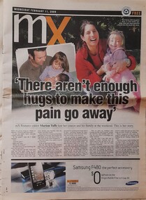
Marion Taffe was Features Editor for Melbourne's MX commuter newspaper and wrote this feature following the loss of her cousin and family at Kinglake in Victoria's Black Saturday bushfires of 2009. Her article was published in newspapers worldwide.non-fictionMarion Taffe was Features Editor for Melbourne's MX commuter newspaper and wrote this feature following the loss of her cousin and family at Kinglake in Victoria's Black Saturday bushfires of 2009. Her article was published in newspapers worldwide.bushfire, black saturday bushfires, victorian bushfires, kinglake, warnambool, marion taffe, mx, newspaper, davey family -
 Eltham District Historical Society Inc
Photograph, George W. Bell, Laughing Waters Road Area, Mar 1965, 1965
Black and white photograph of bushfire aftermath, Laughing Waters Road area, Eltham 1965.laughing waters road, eltham, fires, bush fires, george w bell collection -
Eltham District Historical Society Inc
Photograph, George W. Bell, Fire Aftermath, Laughing Waters Area, 1965
Black and white photograph of bushfire aftermath, Laughing Waters Road area, Eltham 1965.laughing waters road, eltham, fires, bush fires, george w bell collection -
 Eltham District Historical Society Inc
Photograph, George W. Bell, Laughing Waters Area, Eltham, 1965
Black and white photograph of bushfire aftermath Laughing Waters Road area Eltham 1965laughing waters road, eltham, fires, bush fires, george w bell collection -
 Department of Energy, Environment and Climate Action
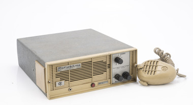
Radiophone STC
After the 1939 bushfires, the Forests Commission Victoria invested heavily in a radically new communications network. After suffering some inevitable delays due to the war, radio VL3AA switched into full operation in October 1945 proudly beaming out 200 watts across the State. But by today’s standards, the technology was primitive and the reception poor unless the user was on a high point somewhere. The radio signal was "line-of-sight" and bounced between fire towers and relay transmitters across the mountains back to the District offices. The advent of solid-state electronics in the 1960s replaced the more delicate valve sets which enabled greater use of vehicle mounted radios. The Commission continued to research, develop and build new radios at its many workshops around Victoria. The network was supported by a large team of skilled radio technicians. The more secure and versatile State Mobile Radio (SMR) digital trunk system came into operation in about 1995. Upgraded Tait Radios were purchased in 2014 after recommendations of the 2009 Bushfires Royal Commission. But it was the convergence of separate technologies such as 5G mobile phones, high-capacity and light-weight lithium batteries, Wi-Fi, the ever-expanding internet, cloud data storage, digital cameras, GPS, personal organisers and hundreds of supporting Apps into powerful smartphones and tablets which revolutionised bushfire communications from the mid-2000s. Radio without handsetSTC - Standard Telephones and Cables Ltd 3AL - Neerim Southbushfire, radios, forests commission victoria (fcv) -
 Department of Energy, Environment and Climate Action
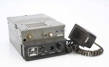
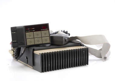
Tait Radio T196
After the 1939 bushfires, the Forests Commission Victoria invested heavily in a radically new communications network. After suffering some inevitable delays due to the war, radio VL3AA switched into full operation in October 1945 proudly beaming out 200 watts across the State. But by today’s standards, the technology was primitive and the reception poor unless the user was on a high point somewhere. The radio signal was "line-of-sight" and bounced between fire towers and relay transmitters across the mountains back to the District offices. The advent of solid-state electronics in the 1960s replaced the more delicate valve sets which enabled greater use of vehicle mounted radios. The Commission continued to research, develop and build new radios at its many workshops around Victoria. The network was supported by a large team of skilled radio technicians. The more secure and versatile State Mobile Radio (SMR) digital trunk system came into operation in about 1995. Upgraded Tait Radios were purchased in 2014 after recommendations of the 2009 Bushfires Royal Commission. But it was the convergence of separate technologies such as 5G mobile phones, high-capacity and light-weight lithium batteries, Wi-Fi, the ever-expanding internet, cloud data storage, digital cameras, GPS, personal organisers and hundreds of supporting Apps into powerful smartphones and tablets which revolutionised bushfire communications from the mid-2000s. Radio with handsetTait 163FM on metal box plus serial number Tait T196 miniphone on radio unit plus serial number Includes Dick Smith handsetbushfire, radios, forests commission victoria (fcv) -
 Department of Energy, Environment and Climate Action
Radiophone STC MTR 23
After the 1939 bushfires, the Forests Commission Victoria invested heavily in a radically new communications network. After suffering some inevitable delays due to the war, radio VL3AA switched into full operation in October 1945 proudly beaming out 200 watts across the State. But by today’s standards, the technology was primitive and the reception poor unless the user was on a high point somewhere. The radio signal was "line-of-sight" and bounced between fire towers and relay transmitters across the mountains back to the District offices. The advent of solid-state electronics in the 1960s replaced the more delicate valve sets which enabled greater use of vehicle mounted radios. The Commission continued to research, develop and build new radios at its many workshops around Victoria. The network was supported by a large team of skilled radio technicians. The more secure and versatile State Mobile Radio (SMR) digital trunk system came into operation in about 1995. Upgraded Tait Radios were purchased in 2014 after recommendations of the 2009 Bushfires Royal Commission. But it was the convergence of separate technologies such as 5G mobile phones, high-capacity and light-weight lithium batteries, Wi-Fi, the ever-expanding internet, cloud data storage, digital cameras, GPS, personal organisers and hundreds of supporting Apps into powerful smartphones and tablets which revolutionised bushfire communications from the mid-2000s. Radio with handsetSTC - Standard Telephones and Cables Ltdbushfire, radios, forests commission victoria (fcv) -
 Department of Energy, Environment and Climate Action
AWA RT85 Mobile Transceiver
After the 1939 bushfires, the Forests Commission Victoria invested heavily in a radically new communications network. After suffering some inevitable delays due to the war, radio VL3AA switched into full operation in October 1945 proudly beaming out 200 watts across the State. But by today’s standards, the technology was primitive and the reception poor unless the user was on a high point somewhere. The radio signal was "line-of-sight" and bounced between fire towers and relay transmitters across the mountains back to the District offices. The advent of solid-state electronics in the 1960s replaced the more delicate valve sets which enabled greater use of vehicle mounted radios. The Commission continued to research, develop and build new radios at its many workshops around Victoria. The network was supported by a large team of skilled radio technicians. The more secure and versatile State Mobile Radio (SMR) digital trunk system came into operation in about 1995. Upgraded Tait Radios were purchased in 2014 after recommendations of the 2009 Bushfires Royal Commission. But it was the convergence of separate technologies such as 5G mobile phones, high-capacity and light-weight lithium batteries, Wi-Fi, the ever-expanding internet, cloud data storage, digital cameras, GPS, personal organisers and hundreds of supporting Apps into powerful smartphones and tablets which revolutionised bushfire communications from the mid-2000s. Radio with transceiver and handsetbushfire, radios, forests commission victoria (fcv) -
 Department of Energy, Environment and Climate Action
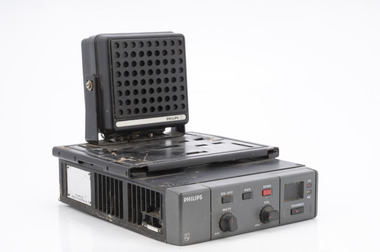
Phillips Radio FM934 with speaker
After the 1939 bushfires, the Forests Commission Victoria invested heavily in a radically new communications network. After suffering some inevitable delays due to the war, radio VL3AA switched into full operation in October 1945 proudly beaming out 200 watts across the State. But by today’s standards, the technology was primitive and the reception poor unless the user was on a high point somewhere. The radio signal was "line-of-sight" and bounced between fire towers and relay transmitters across the mountains back to the District offices. The advent of solid-state electronics in the 1960s replaced the more delicate valve sets which enabled greater use of vehicle mounted radios. The Commission continued to research, develop and build new radios at its many workshops around Victoria. The network was supported by a large team of skilled radio technicians. The more secure and versatile State Mobile Radio (SMR) digital trunk system came into operation in about 1995. Upgraded Tait Radios were purchased in 2014 after recommendations of the 2009 Bushfires Royal Commission. But it was the convergence of separate technologies such as 5G mobile phones, high-capacity and light-weight lithium batteries, Wi-Fi, the ever-expanding internet, cloud data storage, digital cameras, GPS, personal organisers and hundreds of supporting Apps into powerful smartphones and tablets which revolutionised bushfire communications from the mid-2000s. Radio with speakerbushfire, radios, forests commission victoria (fcv) -
 Department of Energy, Environment and Climate Action
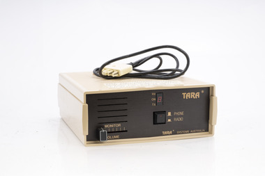
TARA radio/phone interface
After the 1939 bushfires, the Forests Commission Victoria invested heavily in a radically new communications network. After suffering some inevitable delays due to the war, radio VL3AA switched into full operation in October 1945 proudly beaming out 200 watts across the State. But by today’s standards, the technology was primitive and the reception poor unless the user was on a high point somewhere. The radio signal was "line-of-sight" and bounced between fire towers and relay transmitters across the mountains back to the District offices. The advent of solid-state electronics in the 1960s replaced the more delicate valve sets which enabled greater use of vehicle mounted radios. The Commission continued to research, develop and build new radios at its many workshops around Victoria. The network was supported by a large team of skilled radio technicians. The more secure and versatile State Mobile Radio (SMR) digital trunk system came into operation in about 1995. Upgraded Tait Radios were purchased in 2014 after recommendations of the 2009 Bushfires Royal Commission. But it was the convergence of separate technologies such as 5G mobile phones, high-capacity and light-weight lithium batteries, Wi-Fi, the ever-expanding internet, cloud data storage, digital cameras, GPS, personal organisers and hundreds of supporting Apps into powerful smartphones and tablets which revolutionised bushfire communications from the mid-2000s. Portable radio with leather carrycase and strapTARA Systems Australia Connected to FCV radios to allow field staff to call a fixed line telephone / office etc Used by for the Minister Joan Kirner vehicle.bushfire, radios, forests commission victoria (fcv) -
 Department of Energy, Environment and Climate Action
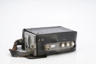
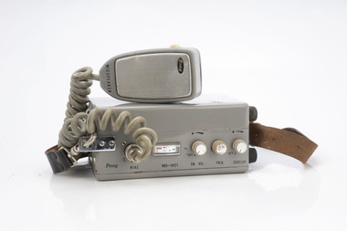
Pony Portable radio
After the 1939 bushfires, the Forests Commission Victoria invested heavily in a radically new communications network. After suffering some inevitable delays due to the war, radio VL3AA switched into full operation in October 1945 proudly beaming out 200 watts across the State. But by today’s standards, the technology was primitive and the reception poor unless the user was on a high point somewhere. The radio signal was "line-of-sight" and bounced between fire towers and relay transmitters across the mountains back to the District offices. The advent of solid-state electronics in the 1960s replaced the more delicate valve sets which enabled greater use of vehicle mounted radios. The Commission continued to research, develop and build new radios at its many workshops around Victoria. The network was supported by a large team of skilled radio technicians. The more secure and versatile State Mobile Radio (SMR) digital trunk system came into operation in about 1995. Upgraded Tait Radios were purchased in 2014 after recommendations of the 2009 Bushfires Royal Commission. But it was the convergence of separate technologies such as 5G mobile phones, high-capacity and light-weight lithium batteries, Wi-Fi, the ever-expanding internet, cloud data storage, digital cameras, GPS, personal organisers and hundreds of supporting Apps into powerful smartphones and tablets which revolutionised bushfire communications from the mid-2000s. Portable radio with leather carrycase and strapModel CD7055 Transceiverbushfire, radios, forests commission victoria (fcv) -
 Department of Energy, Environment and Climate Action
Pony Portable radio with handset
After the 1939 bushfires, the Forests Commission Victoria invested heavily in a radically new communications network. After suffering some inevitable delays due to the war, radio VL3AA switched into full operation in October 1945 proudly beaming out 200 watts across the State. But by today’s standards, the technology was primitive and the reception poor unless the user was on a high point somewhere. The radio signal was "line-of-sight" and bounced between fire towers and relay transmitters across the mountains back to the District offices. The advent of solid-state electronics in the 1960s replaced the more delicate valve sets which enabled greater use of vehicle mounted radios. The Commission continued to research, develop and build new radios at its many workshops around Victoria. The network was supported by a large team of skilled radio technicians. The more secure and versatile State Mobile Radio (SMR) digital trunk system came into operation in about 1995. Upgraded Tait Radios were purchased in 2014 after recommendations of the 2009 Bushfires Royal Commission. But it was the convergence of separate technologies such as 5G mobile phones, high-capacity and light-weight lithium batteries, Wi-Fi, the ever-expanding internet, cloud data storage, digital cameras, GPS, personal organisers and hundreds of supporting Apps into powerful smartphones and tablets which revolutionised bushfire communications from the mid-2000s. Portable radio with leather carrycase and strapModel CD7055 Transceiverbushfire, radios, forests commission victoria (fcv) -
 Department of Energy, Environment and Climate Action
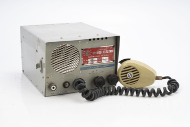
McLeod Electric HF Radio
After the 1939 bushfires, the Forests Commission Victoria invested heavily in a radically new communications network. After suffering some inevitable delays due to the war, radio VL3AA switched into full operation in October 1945 proudly beaming out 200 watts across the State. But by today’s standards, the technology was primitive and the reception poor unless the user was on a high point somewhere. The radio signal was "line-of-sight" and bounced between fire towers and relay transmitters across the mountains back to the District offices. The advent of solid-state electronics in the 1960s replaced the more delicate valve sets which enabled greater use of vehicle mounted radios. The Commission continued to research, develop and build new radios at its many workshops around Victoria. The network was supported by a large team of skilled radio technicians. The more secure and versatile State Mobile Radio (SMR) digital trunk system came into operation in about 1995. Upgraded Tait Radios were purchased in 2014 after recommendations of the 2009 Bushfires Royal Commission. But it was the convergence of separate technologies such as 5G mobile phones, high-capacity and light-weight lithium batteries, Wi-Fi, the ever-expanding internet, cloud data storage, digital cameras, GPS, personal organisers and hundreds of supporting Apps into powerful smartphones and tablets which revolutionised bushfire communications from the mid-2000s. Radio with handsetCall Sign VJ3NVbushfire, radios, forests commission victoria (fcv) -
 Department of Energy, Environment and Climate Action
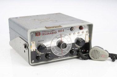
AWA Teleradio 60A (similar to item A/101)
After the 1939 bushfires, the Forests Commission Victoria invested heavily in a radically new communications network. After suffering some inevitable delays due to the war, radio VL3AA switched into full operation in October 1945 proudly beaming out 200 watts across the State. But by today’s standards, the technology was primitive and the reception poor unless the user was on a high point somewhere. The radio signal was "line-of-sight" and bounced between fire towers and relay transmitters across the mountains back to the District offices. The advent of solid-state electronics in the 1960s replaced the more delicate valve sets which enabled greater use of vehicle mounted radios. The Commission continued to research, develop and build new radios at its many workshops around Victoria. The network was supported by a large team of skilled radio technicians. The more secure and versatile State Mobile Radio (SMR) digital trunk system came into operation in about 1995. Upgraded Tait Radios were purchased in 2014 after recommendations of the 2009 Bushfires Royal Commission. But it was the convergence of separate technologies such as 5G mobile phones, high-capacity and light-weight lithium batteries, Wi-Fi, the ever-expanding internet, cloud data storage, digital cameras, GPS, personal organisers and hundreds of supporting Apps into powerful smartphones and tablets which revolutionised bushfire communications from the mid-2000s. AWA Teleradio Transmitter / Receiver Used in FCV vehiclesType ING 1355bushfire, radios, forests commission victoria (fcv) -
 Department of Energy, Environment and Climate Action
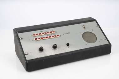
VHF Desk control unit (National parks service)
After the 1939 bushfires, the Forests Commission Victoria invested heavily in a radically new communications network. After suffering some inevitable delays due to the war, radio VL3AA switched into full operation in October 1945 proudly beaming out 200 watts across the State. But by today’s standards, the technology was primitive and the reception poor unless the user was on a high point somewhere. The radio signal was "line-of-sight" and bounced between fire towers and relay transmitters across the mountains back to the District offices. The advent of solid-state electronics in the 1960s replaced the more delicate valve sets which enabled greater use of vehicle mounted radios. The Commission continued to research, develop and build new radios at its many workshops around Victoria. The network was supported by a large team of skilled radio technicians. The more secure and versatile State Mobile Radio (SMR) digital trunk system came into operation in about 1995. Upgraded Tait Radios were purchased in 2014 after recommendations of the 2009 Bushfires Royal Commission. But it was the convergence of separate technologies such as 5G mobile phones, high-capacity and light-weight lithium batteries, Wi-Fi, the ever-expanding internet, cloud data storage, digital cameras, GPS, personal organisers and hundreds of supporting Apps into powerful smartphones and tablets which revolutionised bushfire communications from the mid-2000s. VZ3 - CAbushfire, radios, forests commission victoria (fcv) -
 Department of Energy, Environment and Climate Action
Motorola portable radio
After the 1939 bushfires, the Forests Commission Victoria invested heavily in a radically new communications network. After suffering some inevitable delays due to the war, radio VL3AA switched into full operation in October 1945 proudly beaming out 200 watts across the State. But by today’s standards, the technology was primitive and the reception poor unless the user was on a high point somewhere. The radio signal was "line-of-sight" and bounced between fire towers and relay transmitters across the mountains back to the District offices. The advent of solid-state electronics in the 1960s replaced the more delicate valve sets which enabled greater use of vehicle mounted radios. The Commission continued to research, develop and build new radios at its many workshops around Victoria. The network was supported by a large team of skilled radio technicians. The more secure and versatile State Mobile Radio (SMR) digital trunk system came into operation in about 1995. Upgraded Tait Radios were purchased in 2014 after recommendations of the 2009 Bushfires Royal Commission. But it was the convergence of separate technologies such as 5G mobile phones, high-capacity and light-weight lithium batteries, Wi-Fi, the ever-expanding internet, cloud data storage, digital cameras, GPS, personal organisers and hundreds of supporting Apps into powerful smartphones and tablets which revolutionised bushfire communications from the mid-2000s. Portable radio with aerial and charging portMX 360bushfire, radios, forests commission victoria (fcv) -
 Department of Energy, Environment and Climate Action
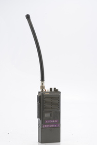
Sawtron portable radio
After the 1939 bushfires, the Forests Commission Victoria invested heavily in a radically new communications network. After suffering some inevitable delays due to the war, radio VL3AA switched into full operation in October 1945 proudly beaming out 200 watts across the State. But by today’s standards, the technology was primitive and the reception poor unless the user was on a high point somewhere. The radio signal was "line-of-sight" and bounced between fire towers and relay transmitters across the mountains back to the District offices. The advent of solid-state electronics in the 1960s replaced the more delicate valve sets which enabled greater use of vehicle mounted radios. The Commission continued to research, develop and build new radios at its many workshops around Victoria. The network was supported by a large team of skilled radio technicians. The more secure and versatile State Mobile Radio (SMR) digital trunk system came into operation in about 1995. Upgraded Tait Radios were purchased in 2014 after recommendations of the 2009 Bushfires Royal Commission. But it was the convergence of separate technologies such as 5G mobile phones, high-capacity and light-weight lithium batteries, Wi-Fi, the ever-expanding internet, cloud data storage, digital cameras, GPS, personal organisers and hundreds of supporting Apps into powerful smartphones and tablets which revolutionised bushfire communications from the mid-2000s. Portable radio with aerialSwifts Creek portable 7bushfire, radios, forests commission victoria (fcv) -
 Department of Energy, Environment and Climate Action
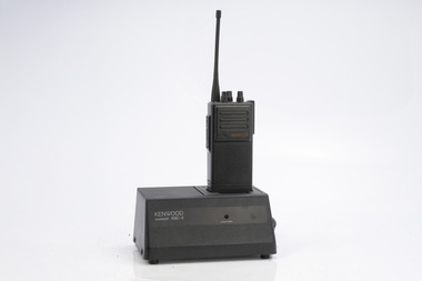
Kenwood portable radio and charger
After the 1939 bushfires, the Forests Commission Victoria invested heavily in a radically new communications network. After suffering some inevitable delays due to the war, radio VL3AA switched into full operation in October 1945 proudly beaming out 200 watts across the State. But by today’s standards, the technology was primitive and the reception poor unless the user was on a high point somewhere. The radio signal was "line-of-sight" and bounced between fire towers and relay transmitters across the mountains back to the District offices. The advent of solid-state electronics in the 1960s replaced the more delicate valve sets which enabled greater use of vehicle mounted radios. The Commission continued to research, develop and build new radios at its many workshops around Victoria. The network was supported by a large team of skilled radio technicians. The more secure and versatile State Mobile Radio (SMR) digital trunk system came into operation in about 1995. Upgraded Tait Radios were purchased in 2014 after recommendations of the 2009 Bushfires Royal Commission. But it was the convergence of separate technologies such as 5G mobile phones, high-capacity and light-weight lithium batteries, Wi-Fi, the ever-expanding internet, cloud data storage, digital cameras, GPS, personal organisers and hundreds of supporting Apps into powerful smartphones and tablets which revolutionised bushfire communications from the mid-2000s. Portable radio with aerial and charging portKSC 5bushfire, radios, forests commission victoria (fcv) -
 Department of Energy, Environment and Climate Action
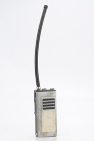
ITT Portable radio
After the 1939 bushfires, the Forests Commission Victoria invested heavily in a radically new communications network. After suffering some inevitable delays due to the war, radio VL3AA switched into full operation in October 1945 proudly beaming out 200 watts across the State. But by today’s standards, the technology was primitive and the reception poor unless the user was on a high point somewhere. The radio signal was "line-of-sight" and bounced between fire towers and relay transmitters across the mountains back to the District offices. The advent of solid-state electronics in the 1960s replaced the more delicate valve sets which enabled greater use of vehicle mounted radios. The Commission continued to research, develop and build new radios at its many workshops around Victoria. The network was supported by a large team of skilled radio technicians. The more secure and versatile State Mobile Radio (SMR) digital trunk system came into operation in about 1995. Upgraded Tait Radios were purchased in 2014 after recommendations of the 2009 Bushfires Royal Commission. But it was the convergence of separate technologies such as 5G mobile phones, high-capacity and light-weight lithium batteries, Wi-Fi, the ever-expanding internet, cloud data storage, digital cameras, GPS, personal organisers and hundreds of supporting Apps into powerful smartphones and tablets which revolutionised bushfire communications from the mid-2000s. Portable radio with aerialCFL Orbost Regionbushfire, radios, forests commission victoria (fcv) -
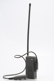 Department of Energy, Environment and Climate Action
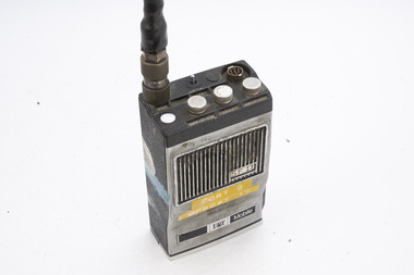
Philips portable radio HPFX
After the 1939 bushfires, the Forests Commission Victoria invested heavily in a radically new communications network. After suffering some inevitable delays due to the war, radio VL3AA switched into full operation in October 1945 proudly beaming out 200 watts across the State. But by today’s standards, the technology was primitive and the reception poor unless the user was on a high point somewhere. The radio signal was "line-of-sight" and bounced between fire towers and relay transmitters across the mountains back to the District offices. The advent of solid-state electronics in the 1960s replaced the more delicate valve sets which enabled greater use of vehicle mounted radios. The Commission continued to research, develop and build new radios at its many workshops around Victoria. The network was supported by a large team of skilled radio technicians. The more secure and versatile State Mobile Radio (SMR) digital trunk system came into operation in about 1995. Upgraded Tait Radios were purchased in 2014 after recommendations of the 2009 Bushfires Royal Commission. But it was the convergence of separate technologies such as 5G mobile phones, high-capacity and light-weight lithium batteries, Wi-Fi, the ever-expanding internet, cloud data storage, digital cameras, GPS, personal organisers and hundreds of supporting Apps into powerful smartphones and tablets which revolutionised bushfire communications from the mid-2000s. Portable radio with aerial and handsetbushfire, radios, forests commission victoria (fcv)