Showing 939 items
matching channels
-
 Port Melbourne Historical & Preservation Society
Plan - Metalling, watertables, channelling and asphalte paths, Engineering Department, Town of Port Melbourne, 1893 - 1919
Type sections for metalling, watertables, channelling and asphalte (tarpaved) paths. Loan No.5 1893.engineering department - city of port melbourne, engineering - roads, streets, lanes, and footpaths. -
Tatura Irrigation & Wartime Camps Museum
Photograph, Clark D
Waranga basin was commenced in 1902Black and white photograph of national channel, flowing into Waranga Basin. Basin wall in backgroundon back - "Waranga Basin"waranga basin, waranga, irrigation -
Whitehorse Historical Society Inc.
Article, The Bushranger rides again, 01/07///08/1960
Article on the filming of Channel 7 producer Ian James' film 'The Great escort robbery'Article on the filming of Channel 7 producer Ian James' film 'The Great escort robbery'Article on the filming of Channel 7 producer Ian James' film 'The Great escort robbery'the great escort robbery (film), chanel 7 -
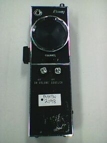 Ambulance Victoria Museum
Radio, Two Way, Pony CB-36, Kanda Tsushin Kogyo Company Ltd, Pony Mid 1970,s
When introduced across the emergency services and used in the 1960s and 1970s these radios for the first time allowed for easy two radio communications between the police, fire services, ambulance, State Emergency Service and St John Ambulance. Source Peter Neylon serving paramedic and AHSV member 17 October 2016.Silver and black hand held radio with two channels and volume and squelch buttons on front.Pony -
 Kew Historical Society Inc
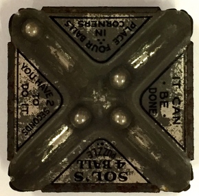
Leisure object - Hand-Held Puzzle, Sol's, Sol's 4 Ball Puzzle, Twentieth Century
Due to the generosity of a number of donors, the Kew Historical Society has a wide range of games and puzzles in its collection; typically designed for children's use. A number of the puzzles are European-made, generally of British origin, however there are a number that were made for the Australian market by Australian manufacturers. Metal and glass puzzle requiring the player to get a four metal balls into 4 channels."Sol's 4 Ball Puzzle / It can be done / Place four balls in containers / You have 2 seconds to do it."games, puzzles, toys -
 Melton City Libraries
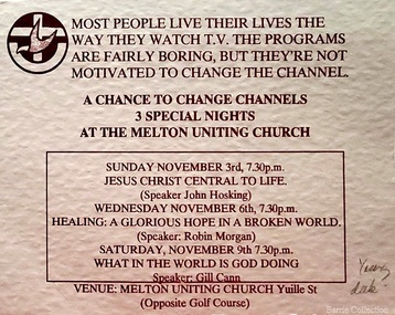
Card, Melton Uniting Church invite, Unknown
"A Chance to Change Channels 3 Special Nights" event held at the Melton Uniting Church churches -
Tatura Irrigation & Wartime Camps Museum
Photograph, Goulburn Weir, 1890
Taken by photographer for State Rivers and Water Supply Commission.Medium sized black and white photograph. View across weir showing partially completed channel outlet. Partially completed brick control building on top of wall joining the weir and channel outlets, hourse, cart, and driver bottom right.victoria state rivers and water supply commission, goulburn weir -
Tatura Irrigation & Wartime Camps Museum
Photograph, East Goulburn Main Channel, 1957
Taken by the photographer for Victoria State Rivers and Water Supply Commission.Large sepia photograph dry mounted on cream cardboard. 15" diameter concrete pylon, wooden scaffolding, with two men, left foreground, looking up into syphon mouth, one pointing right arm and index finger of right hand.Below Photo: "East Goulburn Main Channel / Construction of 15" Diameter Concrete Syphon" irrigation, goulburn, victoria state rivers and water supply commission, channel -
 Bacchus Marsh & District Historical Society
Map, Lerderderg District Proposed Irrigation and Water Supply Trust (B) Plan Showing Proposed Works
The 1886 Irrigation Act in Victoria introduced the first legislation in Australia designed to enable the creation of a detailed scheme for agricultural irrigation. Part of the legislation saw the use of government funds for local irrigation projects. These local projects were managed by local irrigation trusts. The Lerderderg Irrigation and Water Supply Trust was formed in 1890. This map depicts the proposed area of the Trust and proposed works such as channels and weirs.Printed paper map of the proposed Lerderderg District Irrigation and Water Supply area showing proposed works. The map scale is 40 chains + 1 inch. The Lerderderg District lies within the Parishes of Korkuperrumul and Merrimu in the County of Bourke. At the top of the map above its title is the letter 'B; in capital lettering. A series of proposed channels are indicated on the map in red lines. A proposed weir site and alternative weir site are also indicated on the map. irrigation, water supply, lerderderg irrigation and water supply trust -
 Flagstaff Hill Maritime Museum and Village
Document - Navigation Chart, Entrance to Port Phillip
British Admiralty Navigation Chart - Australia, Victoria -Entrance to Port Phillip including the Banks and Channels.warrnambool, shipwrecked-coast, flagstaff-hill, flagstaff-hill-maritime-museum, maritime-museum, shipwreck-coast, flagstaff-hill-maritime-village, shipwrecked-artefact, navigation chart, british admiralty navigation chart, british admiralty, entrance to port phillip -
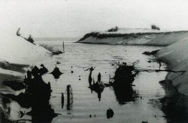
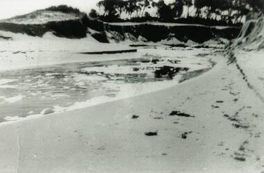 Phillip Island and District Historical Society Inc.
Photograph, 1954
One of a collection of photos donated by Daryl JohnsBlack & White photograph of Woolamai Bight - swamp water breaking through the channel onto the beach.woolamai bight, phillip island, daryl johns -
 Bendigo Historical Society Inc.
Photograph - CASTLEMAINE GAS COMPANY COLLECTION: PHOTO BENDIGO CREEK
3 workers standing on wall of channel looking at the trench being dug and the pipe ready to be connectedKodakbendigo, waterworks, bendigo creek -
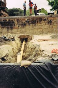
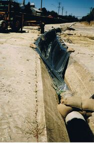 Bendigo Historical Society Inc.
Photograph - CASTLEMAINE GAS COMPANY COLLECTION: PHOTO WATER CHANNEL
Water channel, with some sandbags, part of it covered in plastic. An excavator at top left hand sideKodakorganisation, industry, gas and fuel -
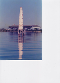 Port Melbourne Historical & Preservation Society
Photograph - Front channel beacon, Port Melbourne, Alison Kelly, c. 1989
Part of the collection of photographs by Alison Kelly passed on to Pat Grainger who in turn donated them to the society. Refer Alison Kelly collectionColour photograph of the front channel beacon lighthouse with the outer shed on Princes Pier in the background. c1989piers and wharves - princes pier, beacons, alison kelly -
 Whitehorse Historical Society Inc.
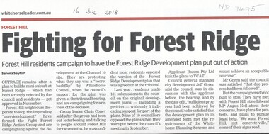
Article, Fighting For Forest Ridge, 2018
The Fight Forest Ridge Action Group is campaigning against the over-development at the Channel 10 site.The Fight Forest Ridge Action Group is campaigning against the over-development at the Channel 10 site.The Fight Forest Ridge Action Group is campaigning against the over-development at the Channel 10 site.forest hill, forest ridge, fight forest ridge action group, channel 10 -
 Lakes Entrance Historical Society
Photograph - Snake Island, 1930c
Black and white photograph, showing eastern end of Rigby Island, Snake Island, at Lakes Entrance, Victoria. Reeves Channel below foreground hill, Hopetoun Channel between dunes and islands with fish pens in distance. Two people sitting on hill in foreground.islands, waterways, topography, room display -
 Halls Gap & Grampians Historical Society
Photograph - Sepia
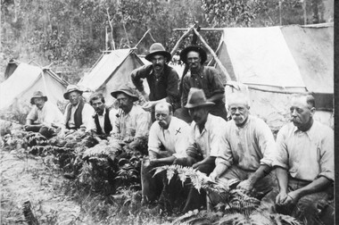
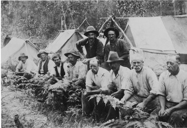
... Channels ...Grampians Halls Gap & Stoney Creek dredge. circa 1909 . 2nd man from right is Alfred D'/alton; 4th from right is James OliverPhoto shows eight men seated, two standing. 3 tents in background.Grampians Hallls Gap & Stoney Creek dredge circa 1909 written on backpeople, d'alton, water supplies, channels -
 Halls Gap & Grampians Historical Society
Photograph - Sepia, C 1909
... Channels ...Grampians halls Gap at Stoney Creek Dredge. The site of the Stoney Creek diggings was in the upper catchment area of the creek, beside Silverband Road. For further information see: 'Bridging the Gap' by Ida Stanton, p. 49 and 'Victoria's Wonderland' by Halls Gap and Grampians Historical Society, p. 41.Photo shows eight men seated, two standing, 3 tents in background. 2nd right Alfred D'Alton 4th Right James Oliverwater supplies, d'alton, water supplies, channels -
 Lakes Entrance Historical Society
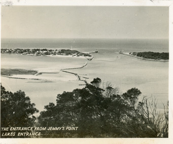
Postcard - The Entrance, 1940c
Originally in a pack of miniature postcards produced for sale to tourists.Black and white small format postcard of the Western end of Bullock Island, Reeves and Entrance Channels, the Entrance and Carpenter Town at the New Works. Taken from Jemmys Point, it shows rock groynes built to channel water flow to the Entrance. Lakes Entrance VictoriaThe Entrance Jemmys Point Lakes Entrance V2 topography, waterways -
 Lakes Entrance Historical Society
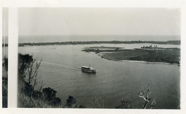
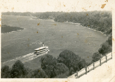
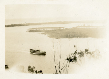
Photograph - S.S. Gippsland, 1920c
Black and white photograph showing S S Gippsland in Reeves Channel, sailing west towards Metung, taken from Jemmys Point and showing Snake Island and end of Rigby Island and hummocks on far side of Hopetoun Channel in background. Lakes Entrance Victoria waterways, ships and shipping -
 Lakes Entrance Historical Society
Photograph - S.S. Gippsland, 1920c
Black and white photograph showing S S Gippsland in Reeves Channel, sailing west towards Metung, taken from Jemmys Point and showing Snake Island and end of Rigby Island and hummocks on far side of Hopetoun Channel in background. Lakes Entrance Victoria waterways, ships and shipping, islands -
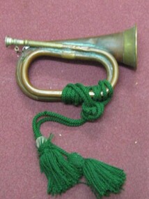 Running Rabbits Military Museum operated by the Upwey Belgrave RSL Sub Branch
Bugle
Australian bugle with lanyard attached. Used by Clarries Sutcliffe while HMAT Ballarat sank in the English Channel.ephemera, ww1, army -
Tatura Irrigation & Wartime Camps Museum
Book, Taming the Wilderness, 1985
Written as a memoir of one family's contribution to the development of australia. A Lawrence is son in law of J.H.Davies who farmed Hill Top.Blue cardboard cover. Illustrated with photo. Construction of Waranga Mallee channel. Back cover - Contributing membersTom, with best wishes for a very Happy Christmas and prosperous New Year love Pearl Shields (Davies "Hill Top") 3/33 Gleeden St Brighton 3187.|also signed - with best wishes A E Lawrencebooks, history, local -
Tatura Irrigation & Wartime Camps Museum
Book, The Supply of Water for Irrigation in Victoria 1881-1981, 1988
Early history of irrigation in Victoria. From 1981 the name changed from State Rivers & Water Supply Commission to Rural Water Commission. Major changes have occurred sinceCream plasticized cover. Black writing. Photo of horse team and scoop working on Waranga Basin or channelsirrigation, books, history, local, rural, industry -
Lakes Entrance Historical Society
Mixed Media - Compact Disc, The Church of Jesus Christ of Latter Day Saints, 1999
Family History Resource file for England, Scotland, Wales, Channel Islands, Isle of Man and Royal Navy.genealogy -
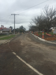 Victorian Interpretive Projects Inc.
Photograph - Colour, Clare Gervasoni, Kerb and Channelling at Armstrong Street South, Ballarat, 1916, 24/03/2016
A number of colour photographs showing concrete kerb and channeling at Armstrong Street South, Ballarat, taken from South Street. Although in an heritage overlay, the kerb and channeling changed the heritage feel of the block. Some photos show original bluestone gutters that were not destroyed during the process.armstrong street south, south street, ballarat, kerb and channelling, roadworks, bluestone gutters -
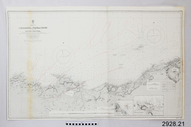 Flagstaff Hill Maritime Museum and Village
Document - Navigation Chart, C. Bougaroni to Fratelli Rocks including the Galita Channel
British Admiralty Navigation Chart - Africa, North Coast - C. Bougaroni to Fratelli Rocks and including The Galita Channelwarrnambool, shipwrecked-coast, flagstaff-hill, flagstaff-hill-maritime-museum, maritime-museum, shipwreck-coast, flagstaff-hill-maritime-village, shipwrecked-artefact, british admiralty navigation chart, navigation chart, c. bougaroni to fratelli rocks including the galita channel -
 Phillip Island and District Historical Society Inc.
Photograph, 1954
One of a collection of photos donated by Daryl JohnsBlack & White Photograph of Woolamai Bight. Water and land masses. Swamp water broke through the channel to the beach.phillip island, woolamai bight, daryl johns -
Port Melbourne Historical & Preservation Society
Document - Specification, Metalling and channelling Liardet Street from Esplanade East to Esplanade West, 14 Mar 1893
Specifications (102.1) & Plan (102.2) for metalling and channelling Liardet Street from Esplanade East to Esplanade West 1893..Both signed by J.J. Bartlett. (Mayor).engineering - roads streets lanes and footpaths, town planning, town clerks, mayors, arthur victor heath, james john bartlett, liardet street