Showing 1938 items
matching flood
-
 Greensborough Historical Society
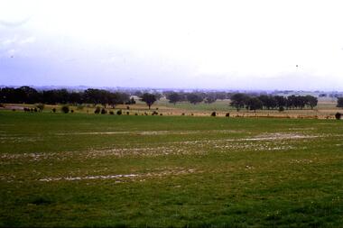
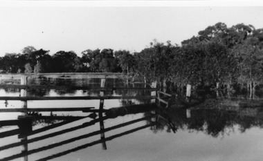
Slide - Photograph, John Ramsdale, Plenty River flood plain: Slide 95, 1990s
Photograph shows water over paddocks; Plenty River flood plain.Part of the John Ramsdale collection of slides and audio visual material.Colour photograph scanned from slide.No maker's marks. No caption on slide.plenty river, plenty river flood -
 Greensborough Historical Society
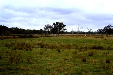
Slide - Photograph, John Ramsdale, Flood plain of the Plenty River: Slide 90, 1990s
Photograph shows farmland on the flood plain of the Plenty River, north of MerndaPart of the John Ramsdale collection of slides and audio visual material.Colour photograph scanned from slide.No maker's marks. Caption on slide "Plenty"plenty river, mernda -
 Greensborough Historical Society
Photograph - Digital image, Plenty River in Flood 2017: Graffiti, 14/12/2017
Photograph of graffiti on the Plenty River bridge, Greensborough. This flood was in December 2017.Digital copy of colour photograph.plenty river, floods, graffiti -
 Eltham District Historical Society Inc
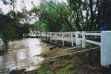
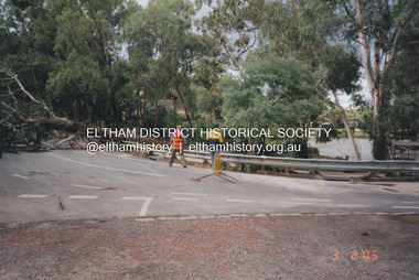
Photograph, Fay Bridge, Diamond Creek in flood, Eltham, 13 November 2004
Significant flood events occurred Nov-Dec 2004 and Jan-Feb 2005.fay bridge collection, diamond creek (creek), 2004-11-13, brougham steet bridge, floods, floodwater, diamond street bridge, rocknall -
 Eltham District Historical Society Inc
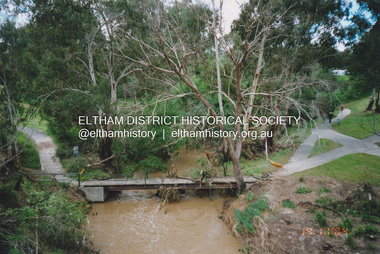
Photograph, Fay Bridge, Flood damage to footbridges over the Diamond Creek, Eltham, 14 November 2004
Significant flood events occurred Nov-Dec 2004 and Jan-Feb 2005.fay bridge collection, 2004-11-14, bridge street bridge, diamond creek (creek), diamond street bridge, flood damage, floods, floodwater, footbridge, main road bridge, susan street oval, withers way -
 Eltham District Historical Society Inc
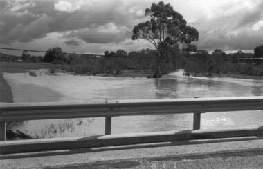
Photograph, Fay Bridge, Diamond Creek in flood, Eltham, 3 February 2005
Significant flood events occurred Nov-Dec 2004 and Jan-Feb 2005.fay bridge collection, bridge street bridge, diamond creek (creek), floods, floodwater, footbridge, main road bridge, susan street oval, diamond street, eltham -
 Malmsbury Historical Society
Photograph (Item), "Peter Bruni In Boat, Malmsbury Flood October 2000", Malmsbury oct 2000
People - "Bruni, Peter" Buildings - Cricket Ground Associated with - Herald Sun Flood -
 Stawell Historical Society Inc
Photograph, Paxton Street Bridge on Concongella Creek in Great Western in flood 1988-- 2 Photos
Paxton Street Bridge Concongella Creek - Great Western. Flooding 2/9/1988stawell -
 Orbost & District Historical Society
black and white photographs, January 1934
These are photographs taken during the 1934 flood at Orbost. From The Argus (Melbourne) on January 10 1934 "Damage estimated at £500,000 has been caused by the floods in the Orbost district. No loss of life occurred, largely owing to the heroic efforts of rescue parties. Many families spent Monday night on the roofs of houses or in trees, surrounded by deep, rushing flood waters." This 1934 flood was devastating, destroying a section of the 1922 Orbost bridge - the centre span was washed away -. wrecking fences, bridges and roads, dumping silt and debris on the rich river flats and drowning cattle.These photographs are pictorial records of the 1934 floods at Orbost, a significant event in the history of Orbost.Nine small black / white photographs of flood damage,3253.2 on back - "Waters rushing down Princes Highway and....of......where you see the waves" 3253.3 on back - "rushing flood waters over Lochiel Park Bridge approach at the rear of picture 1934"orbost-flood-1934 flood-orbost -
 Melbourne Tram Museum
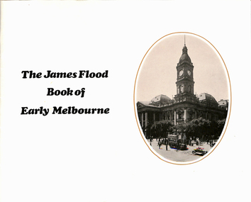
Book, H H Paynting, "The James Flood Book of Early Melbourne", 1970
Book - 36 pages including cover, centre stapled, titled "The James Flood Book of Early Melbourne", edited by H H Paynting. Contains photos of Melbourne and suburbs to the early 1900's, includes cable trams, buses railways. Has credits, other books published.trams, tramways, melbourne, cable trams, buses, railways, street views, street scenes -
 Federation University Historical Collection
Photograph - Photographs, Richard Vincent, Washed Away Bridge at Garibaldi, c1933
Newspaper clipping documents deputations to the Minister of Public Works for grants to be made available for repairs to bridges and roads damaged by heavy flooding in 1933, in particular, the replacement of a stone and concrete bridge over the Leigh River at Garibaldi in the Buninyong Shire. The concrete slabs were still in the water in the 1960s/70s or even later. Three black and white photographs showing flood damage to the bridge over the Leigh River at Garibaldi, plus a photocopy of a newspaper clipping from The Argus December 1933 describing the extent of the flood damage. .1) shows blue stone buttress and collapsed bridge/road. .2) mirror image of above .3) unknown man waling an a girder of the Garibaldi bridge .4) photocopy of newspaper clipping about flood damage from The Argus December 1933Damage by Floods: Bridges washed away (The Argus December 1933)leigh river, garibaldi, buninyong shire, richard vincent, garibaldi bridge -
 Kew Historical Society Inc
Photograph - Flooding in the Willsmere Park, 1993
Willsmere Park is bounded by the the Yarra River, Green Acres Golf Club, Willow Grove and the Eastern Freeway. The land on which the park is now situated was bought by Thomas Wills at the Crown Land Sales of 1846 (Section 56). From the 1840s to the 1940s it was intensively farmed. The park is dominated by very large playing fields, while planting to the southern boundary was undertaken when the Eastern Freeway was built. It is only along the banks of the Yarra that there is any remnant native vegetation. Willsmere Park is of significance as an area of open land that remains from the flood plain that once dominated northern Kew. (Source: Kew Conservation Study, 1988)Original colour small format polaroid photograph of flooding in the Willsmere Park, taken on 16 September 1993."Flooding of Willsmere Park from Yarra 16.9.93"willsmere park, yarra river -- floods -- kew (vic.) -
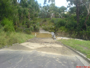 Greensborough Historical Society
Photograph - Digital image, Jasmin Burge, Kalparrin in flood February 2011: group of 5 photographs, 08/02/2011
In February 2011, the Plenty River flooded the Kalparrin area in Greensborough. These photographs were taken by GHS member Jasmin Burge.Digital copy of colour photographs.kalparrin reserve, plenty river, floods -
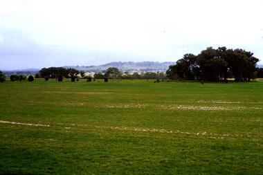 Greensborough Historical Society
Slide - Photograph, John Ramsdale, River flood plain looking west: Slide 67, 1990s
Photograph shows a rural scene with water over ground. This is the Plenty River flood plain looking west, Yan Yean or MerndaPart of the John Ramsdale collection of slides and audio visual material.Colour photograph scanned from slide.No maker's marks. No caption on slide.plenty river, yan yean, mernda -
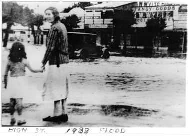 Charlton Golden Grains Museum Inc
Photograph, c.1923
1933 flood at War Memorial corner of Mrs Barber and daughter Unframed B/W Photograph of 1933 flood at War Memorial corner of Mrs Barber and daughter flood, charlton, charlton war memorial -
 Ballarat Heritage Services
Photograph - Photograph - Colour, Tippett's Paddock under Flood, Dean, 2016, 18/09/2016
Tippetts are generational potato farmers at DeanColour photograph of Tippett's farm at Dean, Victoria. dean, flood, tippett, potato, farming, agriculture -
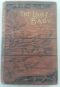 Mont De Lancey
Book, Emma Leslie et al, The Lost Baby - a Story of a Flood, c1880
A schoolgirl story about friendship clashes. A baby is accidentally left in a washing basket and is washed away in a flood. All is resolved and the baby is reunited with the family. Strong religious theme.Brown small hardcover book with black leaf design and lines on front and back cover. Back cover also has the Publisher initials in a swirled design. Gold lettering of title: The Lost Baby - a Story of a Flood. Black and white illustrations throughout. Researched author as none listed on title page - Emma Leslie c. late 1800.fictionA schoolgirl story about friendship clashes. A baby is accidentally left in a washing basket and is washed away in a flood. All is resolved and the baby is reunited with the family. Strong religious theme.children's fiction, friendship, school, religion -
 Ringwood and District Historical Society
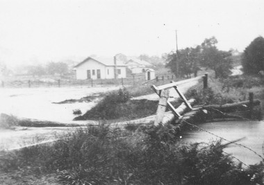
Photograph, Mullum Creek in flood, Ringwood. Adelaide St. Bridge to Reynolds Ave washed away, 1931
Catalogue card reads, "Mullum Creek in flood. Adelaide St. Bridge to Reynolds Ave washed away, 1931". Typed below photograph, "Adelaide St. bridge, to Reynolds Ave washed out in 1931 (Bridge not replaced). 1934?" -
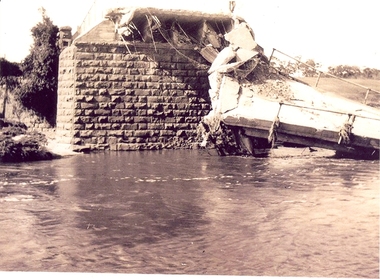
 Kew Historical Society Inc
Photograph - Kane's Bridge on the Yarra River, December 1934
In 1928 a footbridge was erected to link Kew with the public golf course across the Yarra. The total cost of construction came to 250 pounds and the bridge became known as Kane's Bridge. During the 1934 floods the bridge was washed downstream, and was subsequently rebuilt. The present form of the bridge resembles the earlier bridge which crossed from the Yarra Bend Asylum to Kew, further upstream. (VHD)Original, black and white positive of Kane's Bridge in December 1934, when the 'great flood' of the Yarra caused the bridge's destruction. Inscribed verso: "Kane's Bridge Yarra in flood Dec 1934"river yarra, yarra -- kew (vic.), kanes bridge, 1934 floods -
 Kew Historical Society Inc
Photograph - Yarra River in flood at the Willsmere Park, 1993
Willsmere Park is bounded by the the Yarra River, Green Acres Golf Club, Willow Grove and the Eastern Freeway. The land on which the park is now situated was bought by Thomas Wills at the Crown Land Sales of 1846 (Section 56). From the 1840s to the 1940s it was intensively farmed. The park is dominated by very large playing fields, while planting to the southern boundary was undertaken when the Eastern Freeway was built. It is only along the banks of the Yarra that there is any remnant native vegetation. Willsmere Park is of significance as an area of open land that remains from the flood plain that once dominated northern Kew. (Source: Kew Conservation Study, 1988)Original colour small format polaroid photograph of the Yarra River in flood at the Willsmere Park, taken on 16 September 1993."Yarra River at Willsmere Park Flooding 16.9.93"willsmere park, yarra river -- floods -- kew (vic.) -
 Kew Historical Society Inc
Photograph - Flooding in the Willsmere Park, 1993
Willsmere Park is bounded by the the Yarra River, Green Acres Golf Club, Willow Grove and the Eastern Freeway. The land on which the park is now situated was bought by Thomas Wills at the Crown Land Sales of 1846 (Section 56). From the 1840s to the 1940s it was intensively farmed. The park is dominated by very large playing fields, while planting to the southern boundary was undertaken when the Eastern Freeway was built. It is only along the banks of the Yarra that there is any remnant native vegetation. Willsmere Park is of significance as an area of open land that remains from the flood plain that once dominated northern Kew. (Source: Kew Conservation Study, 1988)Original colour small format polaroid photograph of flooding in the Willsmere Park, taken on 16 September 1993."Flooding of shared path from Willsmere Billabong 16.9.93"willsmere park, yarra river -- floods -- kew (vic.), kew billabong -
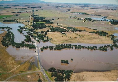 Lake Bolac & District Historical Society
Colour photograph, Wickliffe Flood, Jan .2011
Wickliffe, the flooded Hopkins River flowing from left to right, both under and over the bridge, showing the inundated Glenelg Highway and township. January, 2011. Photograph courtesy James Davidson.wickliffe, hopkins river, flood, glenelg highway -
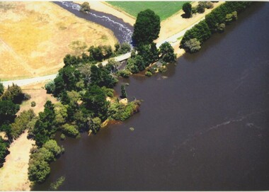 Lake Bolac & District Historical Society
Colour photograph, Jan. 2011 Flood, Lake Bolac and Salt Creek
Jan. 2011 Flood. Debouchment from Lake Bolac into Salt Creek through the natural overflow (centre) and the channel (front left) dug in the 1920's. Photograph courtesy Bill Sharp.lake bolac, salt creek, flood, sharp. -
 Kew Historical Society Inc
Photograph - Flooding of Willsmere Park from Yarra, 1993
Willsmere Park is bounded by the the Yarra River, Green Acres Golf Club, Willow Grove and the Eastern Freeway. The land on which the park is now situated was bought by Thomas Wills at the Crown Land Sales of 1846 (Section 56). From the 1840s to the 1940s it was intensively farmed. The park is dominated by very large playing fields, while planting to the southern boundary was undertaken when the Eastern Freeway was built. It is only along the banks of the Yarra that there is any remnant native vegetation. Willsmere Park is of significance as an area of open land that remains from the flood plain that once dominated northern Kew. (Source: Kew Conservation Study, 1988)Original colour small format polaroid photograph of flooding in Willsmere Park resulting from heavy rain on 15 September 1993."Flooding of Willsmere Park from Yarra 16.9.93"yarra river -- floods -- kew (vic.), willsmere park -
 Eltham District Historical Society Inc
Photograph, Fay Bridge, Diamond Creek in flood at the Bridge Street Bridge, Eltham, c.2004
View looking southeast from Alistair Knox Park (west). The Diamond Creek Trail footbridge is completely submerged. Significant flood events occurred Nov-Dec 2004 and Jan-Feb 2005.fay bridge collection, 2004, bridge street bridge, diamond creek (creek), floods, floodwater -
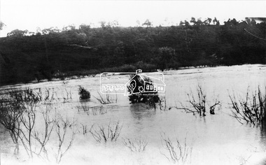 Eltham District Historical Society Inc
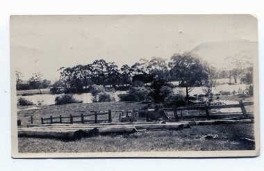
Negative - Photograph, Diamond Creek in Flood, c.1916
Original information recorded with this image suggested the date was 1918 however that was not a significant flood year for the the Diamond Creek at Hurstbridge. Of more significance was 1916. This scene is understood to be somewhere near Wattle Glen and Hurstbridge.This photo forms part of a collection of photographs gathered by the Shire of Eltham for their centenary project book,"Pioneers and Painters: 100 years of the Shire of Eltham" by Alan Marshall (1971). The collection of over 500 images is held in partnership between Eltham District Historical Society and Yarra Plenty Regional Library (Eltham Library) and is now formally known as the 'The Shire of Eltham Pioneers Photograph Collection.' It is significant in being the first community sourced collection representing the places and people of the Shire's first one hundred years.Digital image 4 x 5 inch B&W Negshire of eltham pioneers photograph collection, hurstbridge, wattle glen, floods, diamond creek (creek) -
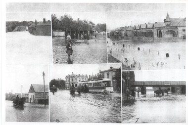 Melbourne Tram Museum
Photograph - Melbourne Flood scenes, 1910c
Composite photograph from a journal showing six flood scenes in the South Melbourne and Port Melbourne area - undated. Photo No. 6 has been identified as Crockford St Port Melbourne. The image with the bridge is possibly Montague St. The photo on the left with a horse drawn cart, has the factory of Jones and Dunn Furniture Manufacturers.Yields information about a flood in the Port Melbourne area.Composite photograph of flood scenes in Melbourne - undated.Melbourne – Floods in the suburbs, No. 6 Crockford St Port Melbourne. Copy neg Mark Plummer collections ex late John Alfred collection.cable trams, melbourne, floods, crockford st, port melbourne, bridges, south melbourne -
 Eltham District Historical Society Inc
Photograph, Flood at Eltham, c.1924
Probably the 1924 flood which damaged the Main Road Bridge Pages from a scrapbook belonging to Heather Jenkins (nee Sargeant) who lived as a child in the Police Residence at 728 Main Road, Eltham in the 1920s.Heather Sargeant was the daughter of Constable W.C. Sargeant, the local police officer in residence at Eltham, 1922-1927Glued on a brown paper scrapbook page (torn from scrapbook) with 8 black and white/sepia photos of varying sizes, 1 newspaper clipping and one greeting card with printed sketch and handwritten captions in ink. On back of page is 1 black and white photo and a large newspaper clipping.eltham, police residence, heather jenkins (nee sargeant), walter withers, constable w.c. sargeant, floods -
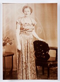 City of Greater Bendigo - Civic Collection
Photograph - Portrait, Monica Flood, Mayoress 1952 - 53, 1957 - 58, 1966 - 67, 1968 - 69, c 1950's
Prior to the election of female Councillors and Mayors in the 1960’s, the Lady Mayoress role was one of the few ways women could officially undertake civic duties. Mayoresses made important contributions to their local communities through their charity work and as ambassadors for their region on a state and federal level. They also undertook some Mayoral duties on occasions when their husband was unavailable. Monica Cecelia Murray was born in 1910 in Strathfieldsaye and married Thomas Flood in 1934. She served as Mayoress for four terms and died in 1973. Mayoress Flood was president of the St Mary's Past Pupul's Association and a patron of the Bendigo Girl Guildes. Reproduction of photographic studio portrait sitting behind oval mount.studio photography, raymond kelly, city of bendigo mayoress, city of greater bendigo portraits, city of bendigo mayor, mayoress flood, mayor t.r. flood -
 Charlton Golden Grains Museum Inc
Photograph, B/W photograph of Flooded Billabong Cadrows Dairy in the bend of the Avoca River
Flooded Billabong Cadrows Dairy in the bend of the Avoca River, Charlton, VictoriaB/W photograph of Flooded Billabong Cadrows Dairy in the bend of the Avoca River, Charlton, Victoriaflood, charlton, avoca river, cadgow