Showing 10997 items matching " land"
-
 Whitehorse Historical Society Inc.
Article, People before profit - land sale opponent, 1992
A community group has criticised Nunawading Council's move to rezone and sell the Vermont South site it uses.A community group has criticised Nunawading Council's move to rezone and sell the Vermont South site it uses. The land is on the corner of Burwood Highway and Livingstone Road which is zoned D 'Public Open Space'. Council has deferred the decision to rezone until after a public meeting.A community group has criticised Nunawading Council's move to rezone and sell the Vermont South site it uses.town planning, city of nunawading, burwood highway, vermont south, livingstone road, vermont south, vermont south -
 Stawell Historical Society Inc
Book, Land Conservation Council, Historic Places Special Investigation South Western Victoria Proposed Recommendations, 1996
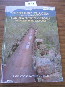
Historic Places Special Investigation South Western Victoria descriptive report Jan 1996Card cover with photo of a water metal water race with moutains in the background Historic places Special Investigation South-Western Victoria Descriptive report Land Conservation Councilstawell heritage -
 Stawell Historical Society Inc
Book, Land Conservation Council, Historic Places Special Investigation South Western Victoria Descriptive Report, 1996
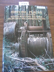
Card cover with a colour photo of part of the Pioneers memorial at deep lead featuring two miners sluicing for gold. Red SpineHistoric Places Special Investigation South Western Victoria Final Recommendations Land Conservation Councilstawell heritage -
 Stawell Historical Society Inc
Book, Land Conservation Council, Historic Places Special Investigation South Western Victoria Final Recommendations, 1997
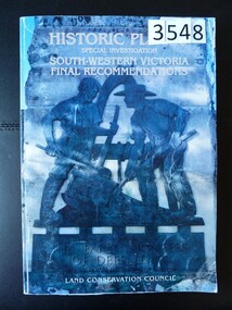
Card Cover with color Photo of Double drum winch at a sawmill mill site Green SpineHistoric Places Special Investigation South-Western Victoria Proposed Recommendations Land Conservation Councilstawell heritage -
 Tatura Irrigation & Wartime Camps Museum
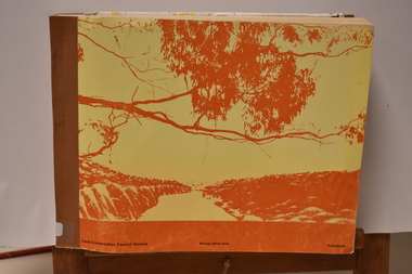
Book - Land Conservation Council Victoria ( Murray Valley Area ), Land Conservation Council Victoria ( Murray Valley Area )
Report on public land use in the Murray Valley area in 1983Mediun size, Yellow and Orange Front Cover. Brown fabric Spine. White back. Heavy white envelope inside back cover that contains mapsnon-fictionReport on public land use in the Murray Valley area in 1983soils and land use -
Lakes Entrance Historical Society
Book, Land Conservation Council Victoria Gippsland Lakes Hinterland Area, 1982
Report describing the physical nature of the land in the Gippsland Lakes (Victoria) Hinterland Study area. History, climate, geomorphology, land use, flora and fauna are presented. 1 map in pocket.waterways, gippsland, natural history, vegetation -
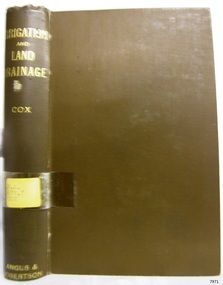 Flagstaff Hill Maritime Museum and Village
Book, Irrigation and Land Drainage
WARRNAMBOOL MECHANICS’ INSTITUTE Warrnambool's Mechanics' Institute (or Institution as it was sometimes called) was one of the earliest in Victoria. On 17th October 1853 a meeting was held where it was resolved to request the Lieutenant Governor of the Colony to grant land for the erection of a Mechanics' Institutes building. A committee was formed at the meeting and Richard Osburne chaired the first meeting of this committee. The land on the North West corner of Banyan and Merri Streets was granted but there were no funds to erect the building. The Formal Rights of the Warrnambool Mechanics' Institute's encompassed its aims and these were officially adopted in1859; "This Institution has for its object the diffusion of literary, scientific, and other useful knowledge amongst its members, excluding all controversial subjects, religious or political. These objects are sought to be obtained by means of a circulating library, a reading room, the establishment of classes, debates, and the occasional delivery of lectures on natural and experimental philosophy, mechanics, astronomy, chemistry, natural history, literature, and the useful and ornamental arts, particularly those which have a more immediate reference to the colony." The Warrnambool Mechanics' Institute opened its first reading room in November1884 in the National School building at the corner of Banyan and Timor Streets. The Institute was funded by member subscription, payable on a quarterly, half yearly or yearly basis. Samuel Hannaford, the Manager of the Warrnambool Bank of Australasia, was the first Honorary Secretary of the Mechanics' Institutes, and an early President and Vice-President. He also gave several of the early lectures in the Reading Room. Another early Secretary, Librarian and lecturer was Marmaduke Fisher, the teacher at the National School. Lecture topics included The Poets and Poetry of Ireland', 'The Birth and Development of the Earth', 'The Vertebrae - with Remarks on the pleasures resulting from the study of Natural History' and 'Architecture'. In 1856 the Reading Room was moved to James Hider's shop in Timor Street, and by 1864 it was located in the bookshop of Davies and Read. In the 1860's the Mechanics' Institute struggled as membership waned but in 1866, after a series of fund raising efforts, the committee was able to purchase land in Liebig Street, on a site then called Market Square, between the weighbridge and the fire station. A Mechanics' Institute building was opened at this site in August 1871. The following year four more rooms were added to the main Reading Room and in 1873 the Artisan School of Design was incorporated into the Institute. The same year Joseph Archibald established a Museum; however it deteriorated when he was transferred to Bendigo in 1877. In 1880, with Archibald's return to Warrnambool, the Museum was re-established, and in 1885 a new building was built at the back of the Institute to accommodate the re-created School of Design, the Art Gallery and the Museum. In 1887 the Museum section was moved to the former court house in Timor Street (for some time the walls of the building formed part of the TAFE cafeteria but all is now demolished)). In 1911 the Museum was transferred back to the original building and the management of the Mechanics' Institute was handed over to the Warrnambool City Council. The Museum and Art Gallery became one and housed many fine works of art, and the Library continued to grow. The building was well patronised, with records showing that at the beginning of the 20th century there were between 500 and 800 visitors. During World War One the monthly figures were in the thousands, with 3,400 people visiting in January 1915. The Museum was a much loved Institution in Warrnambool until the contents of the Museum and Art Gallery were removed to make room for the Warrnambool City Council Engineers' Department. The contents were stored but many of the items were scattered or lost. When the original building was demolished the site became occupied by the Civic Centre, which included the new City Library. (The library was temporarily located in the old Palais building in Koroit Street.) In the process of reorganisation the Collection was distributed amongst the community groups: -The new City Library took some of the historic books and some important documents, historic photographs and newspapers. -The Art Gallery kept the 19th Century art collection and some of the artefacts from the museum. -The Historic Society has some items -The State Museum has some items -Some items were destroyed -Flagstaff Hill Maritime Village has old newspapers, Government Gazettes, most of the Mechanics' Institute Library, ledgers and documents connected to the Mechanics' Institute Library, some framed and unframed art works and some photographs. The Warrnambool Mechanics' Institute Library book collection is deemed to be of great importance because it is one of the few collections in an almost intact state, and many of the books are now very rare and of great value. Irrigation and Land Drainage with surface and subterranean waters Author: W Gibbons Cox Publisher: Angus & Robertson Date: 1906Label on spine cover with typed text RA 631.7 COX Pastedown front endpaper has sticker from Warrnambool Mechanics Institute and Free Librarywarrnambool, shipwrecked-coast, flagstaff-hill, flagstaff-hill-maritime-museum, maritime-museum, shipwreck-coast, flagstaff-hill-maritime-village, shipwrecked-artefact, great ocean road, book, warrnambool library, warrnambool mechanics’ institute, mechanics’ institute library, victorian library board, warrnambool books and records, warrnambool children’s library, warrnambool public library, w gibbons cox, irrigation and land drainage -
![Map, [Coornmill land area available for leasing for grazing, Parish of Coornmill]. Circa 1904](/media/collectors/5e461d8021ea67224c82f2a1/items/677cde147f2053f3e5d277c3/item-media/677cdeea7f2053f3e5d27bb4/item-fit-380x285.jpg) Bacchus Marsh & District Historical Society
Bacchus Marsh & District Historical SocietyMap, [Coornmill land area available for leasing for grazing, Parish of Coornmill]. Circa 1904
This map shows an area of land north of Bacchus Marsh in the Larderderg State Park area known as the Parish of Coornmill.The map indicates an area of land which was to be made available by public tender for grazing leaseholders. The plan to do this was discussed in the Bacchus Marsh Express newspaper on the 16 July, 1904, page 2, column 7. The area reserved for grazing leases is identified by red lines on the map. The Express described the area available for grazing was 12,000 acres.A single page paper map showing an area of land in the Parish of Corrnmill to be made available for grazing leases. A photo lithographed Lands Department Map. No scale indicated. The map is pasted into a bound volume containing 76 maps or plans in total. High resolution digital image stored on BMDHS computer network. coornmill parish maps, lerderderg state park maps, agriculture bacchus marsh area -
 Bayside Gallery - Bayside City Council Art & Heritage Collection
Map, Department of Lands and Survey, Land under the control of the City of Sandringham, 1962
The cadastral map showing land under the control of the City of Brighton in 1962.map, plan, foreshores, sndringham, hampton, beaumaris, cheltenham, department of lands and survey, cartographic material, moorabbin, black rock, street map, city of sandringham, board of lands and works -
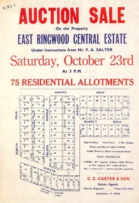 Ringwood and District Historical Society
Flyer, Land Auction Sale Advertisement, East Ringwood Central Estate - 1948
See Victorian Collections reference 5125 for subsequent Central Estate East Ringwood subdivision flyer.Single sided land auction sale advertisement for residential allotments.Auction Sale on the property under instructions from Mr. F.A. Salter. Subdivision includes Dublin Road, Knaith Road, Talofa Avenue, Russet Road, and Shasta Avenue. Agent - C.E. Carter & Son, Main Street, Ringwood. WU 6024. -
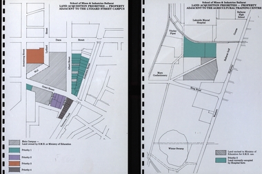 Federation University Historical Collection
Document, Documents relating to land aquisition for School of Mines and Industries Ballarat
School of Mines and Industries Ballarat is a predecessor of Federation University Diagrams relating to land aquisition for School of Mines and Industries Ballarat.school of mines and industries ballarat, land aquisition, car parking -
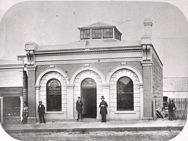 Federation University Historical Collection
Photograph - Black and White Photograph, William Collard Smith's Colonial Land Office
Photograph of illiam Collard Smith's Colonial Land Office in Ballaratwilliam collard smith, colonial land, auctioneer, bluestone, ballarat -
Whitehorse Historical Society Inc.
Article, Council rules for land subdivisions, 1976
'Know your Council' stating rules and procedures for land subdivision.'Know your Council' stating rules and procedures for land subdivision.'Know your Council' stating rules and procedures for land subdivision.city of nunawading, land subdivision -
 Bacchus Marsh & District Historical Society
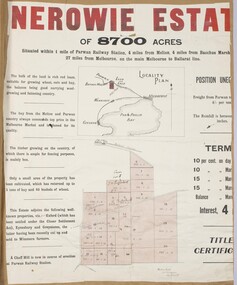
Map, Nerowie Estate Land Sale 1910
The Nerowie Estate was a large rural property of 8,700 acres (3520 hectares) near the locality of Parwan only a few kilometers east of Bacchus Marsh. It had once formed a large part of the land owned by the pioneering Staughton family.A single page paper map showing the land offered for sale from the Nerowie Estate at Parwan near Bacchus Marsh in 1910. The map is pasted into a bound volume containing 76 maps or plans in total. High resolution digital image stored on BMDHS computer network. nerowie estate parwan, land sales parwan, land sales bacchus marsh, staughton family bacchus marsh -
Whitehorse Historical Society Inc.
Pamphlet, City of Nunawading land use statement, 1994
A draft statement from City of Nunawading on land use strategy to establish directions & priorities for land use change and development within the municipality for the remainder of this decade and into the next. Council seeking comments.land use, city of nunawading -
Lakes Entrance Historical Society
Book, Land Conservation Council Victoria Alpine Area, 1977
Report containing information from various sources relevant to the future use of public land in the alpine area of Victoria. History, climate, landform, vegetation, land use, are some of the aspects presented.Ruth Clarktopography, vegetation -
Ringwood and District Historical Society
Document, Land Title for George Pratt, Ringwood, 19th August, 1869. (3 documents)
Black and white documentDocument includes hand written details of License of land to George Pratt. Three separate Land Titles - 10171(a),(b),(c) -show a respective shaded area relevant to each Title. -
University of Melbourne, Burnley Campus Archives
Programme, The University of Melbourne, Faculty of Land and Food Resources, Graduation Ceremony, 2007
graduation -
University of Melbourne, Burnley Campus Archives
Administrative record, School of Land and Environment, Conferring of Degrees, 2009
graduation, burnley campus, creswick campus -
University of Melbourne, Burnley Campus Archives
Newspaper - Newspaper Cutting, Stock and land, Horticultural Science at Burnley Opens Way to Many Jobs, 1971
Full page article in "Stock and Land" August 19, 1971 p 23 on courses and career options.stock and land, courses, burnley horticultural college, careers, evening classes, part-time classes, short courses -
 Whitehorse Historical Society Inc.
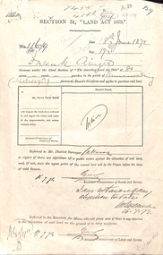
Document - Report, Section 31 Land Act 1869, 01/06/1872
Land application by Frank Ainger, referred to District Surveyor. Report by Mounted Constable Douglas with description of proposed use of land. Map of area. The area is on the corner of Whitehorse Road and Doncaster East Road.ainger, frank, douglas (mounted constable), assistant commissioner of lands and survey, whitehorse road, mitcham, doncaster east road, land settlement -
 Falls Creek Historical Society
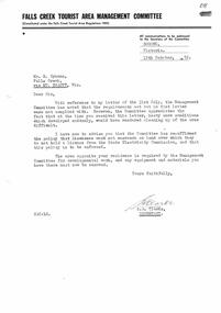
Letter - Falls Creek Tourist Area Management Committee Letter re "Licensees encroaching on land"
Bob Hymans Collection Bob (Herman) Hymans (a former member of the Royal Netherlands Navy was born in Bloemendaal, Holland on 30th September 1922. During World War II he fought against the Japanese in the Dutch East Indies (now Indonesia) and was imprisoned in Changi and on the Burma Railway. After gaining qualifications as a Ski Instructor, Bob arrived in Falls Creek in May 1950. Working as an Instructor and Supervisor at Bogong Lodge, Bob decided his future was in accommodation. He was successful in negotiating an indenture for land from the State Electricity Commission (SEC). It took Bob two years to build his Grande Coeur Chalet but, tragically, it was burned down in August 1961. Bob also built the first Chairlift in Australia. This was a single chairlift and the structure was built from wooden electricity poles. He was constantly full of new ideas and proposals for the village. Bob Hymans died on 7th July 2007. This Collection of documents and letters tells the story of Bob’s endeavours to develop Falls Creek into the ski village it is today.This document is significant because it documents the Rules of Falls Creek Tourist Area Regulations 1959.A letter from the Falls Creek Tourist Area Management Committee reinstating the policy to ensure that licensees must not encroach on land for which they don't hold a license.bob hymans, licensee requirements -
 Bacchus Marsh & District Historical Society
Map, Gaynor Street Land Sales, Maddingley, circa 1880s-1890s
This map was produced for a major sale of land in the Maddingley area of Bacchus Marsh. The precise date of the sale has not been determined. Features present on the map such as the Bacchus Marsh Railway Station indicate the land sale must have taken place some time after 1887 when the Railway Station opened. A single page paper map showing land allotments for sale in the Maddingley area of Bacchus Marsh. Locations shown include Gaynor Street, Maddingley Road South, Parwan Road, Mitchem Street, Typpynge Street, Finn Street and East Maddingley Road. . The map is pasted into a bound volume containing 76 maps or plans in total. High resolution digital image stored on BMDHS computer network. bacchus marsh victoria maps, maddingley victoria maps, land use, maddingley victoria history, land sales bacchus marsh, land sales maddingley -
 Ringwood and District Historical Society
Photograph, View from block of land on Boulevarde, Heathmont, 1960
Written on back of small photograph, "From block of land on Boulevarde, Heathmont, 1960". -
Clunes Museum
Document, VICTORIAN GOVERNMENT DEPT. OF PLANNING, THE RURAL LAND MAPPING PROJECT 1981 - DRAFT, JULY 1981
A REPORT TO THE SHIRE OF TALBOT AND CLUES TO ACCOMPANY AND EXPLAIN THE SET OF PHYSICAL CONSTRAINTS MAPS PRODUCED FOR THE SHIRE AS PART OF THE RURAL LAND MAPPING PROJECT...SOFT COVER, TAN COLOURED DRAFT OF THE RURAL MAPPING PROJECT 1981 - SHIRE OF TALBOT AND CLUNES.non-fictionA REPORT TO THE SHIRE OF TALBOT AND CLUES TO ACCOMPANY AND EXPLAIN THE SET OF PHYSICAL CONSTRAINTS MAPS PRODUCED FOR THE SHIRE AS PART OF THE RURAL LAND MAPPING PROJECT...local history, government, state government, essential services -
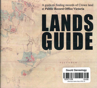 Victorian Aboriginal Corporation for Languages
CD-ROM, Public Record Office Victoria, Lands guide : a guide to finding records of Crown land at Public Record Office Victoria, 2009
A Guide to finding records of Crown land at Public Records Office Victoria.CD-ROM -
University of Melbourne, Burnley Campus Archives
Document, Land Reservations, 1885-1916
Extracts from Victorian Government Gazette on land reservation for Burnley Gardensland resercvations, burnley gardens -
Whitehorse Historical Society Inc.
Document, Compulsory acquisition of land, 1937
Shire of Blackburn & Mitcham, notice of intention to acquire land compulsorily in Blackburn.Shire of Blackburn & Mitcham, notice of intention to acquire land compulsorily in Blackburn.Shire of Blackburn & Mitcham, notice of intention to acquire land compulsorily in Blackburn.shire of blackburn and mitcham, compulsory land acquisition -
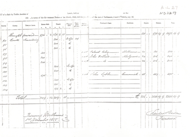
 Whitehorse Historical Society Inc.
Document - Report, Land Sale, 01/10/1855
Report of land sale by public auction, Parish of Nunawading, October 1855cousens, james, williams, william, heading, nalborough, phillip, riley, patrick, blood, thomas, cook -
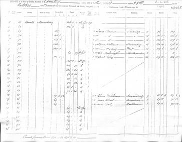
 Whitehorse Historical Society Inc.
Legal record - Report, Land Sale, 01/10/1855
Report of land sale by public auction, Parish of Nunawading, October 1855Report of land sale by public auction, Parish of Nunawading, October 1855Report of land sale by public auction, Parish of Nunawading, October 1855riley, patrick, holland, john, lobb, land sales