Showing 200 items matching " railway avenue"
-
 City of Moorabbin Historical Society (Operating the Box Cottage Museum)
Flyer - Gregg's Electric Station Estate, Moorabbin, 1925
The train line from the city to Frankston was electrified which intensified the sale in the municipality of Moorabbin, particularly land which was in the vicinity of the railway stations.Example of the progress of the Municipality of MoorabbinAdvertising flyer for auction of real estate sales - plan of building blocks for saleGregg's Electric Station Estate, Moorabbin 26 business site and 46 home sites - Knight & Harwood pictures of local sites and buildingssouth road, barry street, south avenue, plym street, moorabbin, moorabbin station, gregg, real estate, auction -
 City of Moorabbin Historical Society (Operating the Box Cottage Museum)
Flyer - Jones' Estate, Bentleigh, 1924
The train line from the city to Frankston was electrified which intensified the sale in the municipality of Moorabbin, particularly land which was in the vicinity of the railway stations.Example of the progress of the Municipality of MoorabbinAdvertising flyer for auction of real estate sales - plan of building blocks for saleJones' Estate, Brewer Road Bentleigh - 63 home sites & 19 business sites - H. C. Costello & Co - A. N. Moorepatterson road, brewer road, phillip street, north avenue, real estate, auction, bentleigh, moorabbin -
 City of Moorabbin Historical Society (Operating the Box Cottage Museum)
Flyer - Moorabbin Electric Station Estate, Moorabbin, 1925
The train line from the city to Frankston was electrified which intensified the sale in the municipality of Moorabbin, particularly land which was in the vicinity of the railway stations.Example of the progress of the Municipality of MoorabbinAdvertising flyer for auction of real estate sales - plan of building blocks for saleMoorabbin Electric Station Estate, Moorabbin - Auction Saturday 30 May 1925 - 65 Residential allotments Auctioneer Knight & Harwoodmoorabbin station, south road, station street, jasper street (now redholme street), central avenue, moorabbin, real estate, auction -
 City of Moorabbin Historical Society (Operating the Box Cottage Museum)
Flyer - Moorabbin Heights Estate, Moorabbin, 1928
The train line from the city to Frankston was electrified which intensified the sale in the municipality of Moorabbin, particularly land which was in the vicinity of the railway stations.Example of the progress of the Municipality of MoorabbinAdvertising flyer for auction of real estate sales - plan of building blocks for saleMoorabbin Heights Estate, Moorabbin - 48 residential allotments - Auction Saturday 24 November 1928moorabbin, bentleigh, east bentleigh, south road, tucker road, hinkler avenue, real estate, auction -
 City of Moorabbin Historical Society (Operating the Box Cottage Museum)
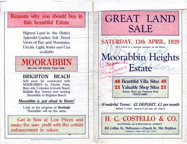
Flyer - Moorabbin Heights Estate, Moorabbin, 1929
The train line from the city to Frankston was electrified which intensified the sale in the municipality of Moorabbin, particularly land which was in the vicinity of the railway stations.Example of the progress of the Municipality of MoorabbinAdvertising flyer for auction of real estate sales - plan of building blocks for saleMoorabbin Heights Estate, Moorabbin 48 Villa sties, 21 Shop sites Sale on Saturday 13 April 1929 - H. C. Costello & CO.point nepean road (nepean highway), harding street, howell street, north avenue, coates street -
 City of Moorabbin Historical Society (Operating the Box Cottage Museum)
Flyer - Ormond Heights, East Bentleigh
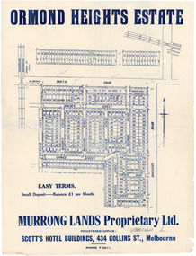
The train line from the city to Frankston was electrified which intensified the sale in the municipality of Moorabbin, particularly land which was in the vicinity of the railway stations.Example of the progress of the Municipality of MoorabbinAdvertising flyer for auction of real estate sales - plan of building blocks for salenorth road, moulden street, george street, garden road, bruce street (now bethwyn street), boundary road (now east boundary road), murrong avenue, bay view street, rochford street, mitchell street, lancaster street, east bentleigh, real estate -
 City of Moorabbin Historical Society (Operating the Box Cottage Museum)
Flyer - Patterson Station Estate, 1927
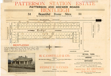
The train line from the city to Frankston was electrified in 1922 which intensified the sale in the municipality of Moorabbin, particularly land which was in the vicinity of the railway stations.Example of the progress of the Municipality of MoorabbinThe train line from the city to Frankston was electrified in 1922 which intensified the sale in the municipality of Moorabbin, particularly land which was in the vicinity of the railway stations.Patterson Station Estate, Bentleigh - 51 home sites - Auction Saturday 26 May 1927 - H. C. Costello & Co.patterson road, purton avenue (now bendigo street), brewer road, real estate, bentleigh, patterson, auction -
 City of Moorabbin Historical Society (Operating the Box Cottage Museum)
Flyer - Gun Club Estate, Highett, 1927
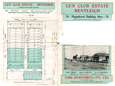
The train line from the city to Frankston was electrified in 1922 which intensified the sale in the municipality of Moorabbin, particularly land which was in the vicinity of the railway stations. York Investments Pty Ltd purchased the land in 1927.Example of the progress of the Municipality of MoorabbinAdvertising flyer for auction of real estate sales - plan of building blocks for saleGun Club Estate, Bentleigh 76 housing blocks - York Investments Pty Ltdthomas street, erica avenue, brewer road, grace street, victor road, melbourne gun club, benteligh, real estate -
 City of Moorabbin Historical Society (Operating the Box Cottage Museum)
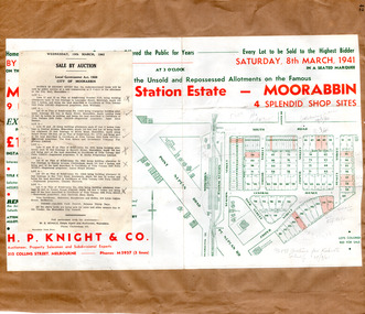
Flyer - Moorabbin Electric Station Estate, Moorabbin, 1941
The train line from the city to Frankston was electrified in 1922 which intensified the sale in the municipality of Moorabbin, particularly land which was in the vicinity of the railway stations. Moorabbin Electric Station Estate Sale of unsold and repossessed Allotments, the original sale was on Saturday 30 May 1925.Example of the progress of the Municipality of MoorabbinAdvertising flyer for auction of real estate sales - plan of building blocks for saleMoorabbin Electric Station Estate, Moorabbin. Auction Saturday 8 March 1941 - 9 villa units 4 shop sitessouth road, station street, taylor street, healey street, jasper street (now redholme street), central avenue, moorabbin, real estate -
 City of Moorabbin Historical Society (Operating the Box Cottage Museum)
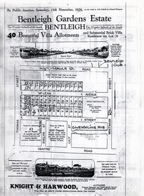
Flyer - Bentleigh Gardens Estate, Bentleigh, 1926
The train line from the city to Frankston was electrified in 1922 which intensified the sale in the municipality of Moorabbin, particularly land which was in the vicinity of the railway stations.Example of the progress of the Municipality of MoorabbinPhotocopy of advertising flyer for auction of real estate sales - plan of building blocks for saleBentleigh Gardens Estate, Bentleigh - 40 housing allotments - Auction Saturday 13 November 1926huntly road (now gawla st), mclean avenue, somers street, thomas street, bentleigh, real estate, auction -
 City of Moorabbin Historical Society (Operating the Box Cottage Museum)
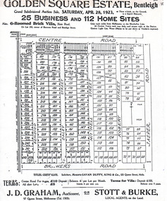
Flyer - Golden Square Estate, Bentleigh, 1923
The train line from the city to Frankston was electrified in 1922 which intensified the sale in the municipality of Moorabbin, particularly land which was in the vicinity of the railway stations.Example of the progress of the Municipality of MoorabbinAdvertising flyer for auction of real estate sales - plan of building blocks for saleGolden Square Estate, Bentleigh 25 business and 112 home sites for auction Saturday April 28 1923centre road, brewers road, jasper road, robert street, mitchell street, daley street, bendigo avenue, bentleigh, real estate, auction -
 City of Moorabbin Historical Society (Operating the Box Cottage Museum)
Flyer - Ozone Hill Estate, Cheltenham, 1923
The train line from the city to Frankston was electrified in 1922 which intensified the sale in the municipality of Moorabbin, particularly land which was in the vicinity of the railway stations.Example of the progress of the Municipality of MoorabbinPhotocopy of Advertising flyer for sale of real estate sales - plan of building blocks for saleOzone Hill Estate, Cheltenham 41 choice residential allotments.victor avenue, weatherall road, cheltenham, real estate, auction -
 City of Whittlesea
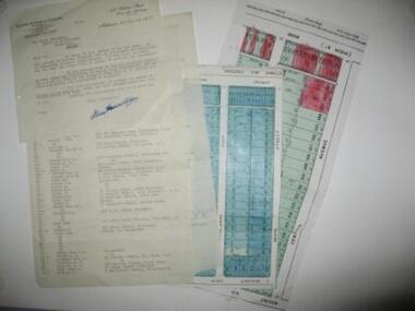
Document - Correspondence, Station Entrance and Railway Platform Estate, 1937
Letter from Ellison, Hewison & O'Collins Solicitors, Melbourne to the Shire of Whittlesea in reponse to a request for the names and addresses of the purchasers of blocks of land on the Station Entrance Estate and Railway Platform Estate, Thomastown. Both estates where originally subdived and sold in the mid 1920s. The collection includes a letter, a list of owners and their address details and the lot they own, and plans of both estates, which have been cut out of the original estate sale posters. Streets include High Street (Epping Road), Mount View Road, Pleasant Road, Central Avenue, Highlands Road and Main Street, ThomastownLetter, paper 3 pages, 2 plans. Letter from Ellison, Hewison & O'Collins Solicitors, Melbourne to the Shire of Whittlesea in reponse to a request for the names and addresses of the purchasers of blocks of land on the Station Entrance Estate and Railway Platform Estate, Thomastown. -
 City of Ballarat
Public Artwork, Joseph Benedict Chifley (Prime Ministers' Walk) by Ken Palmer, 1946
Joseph Benedict 'Ben' Chifley, Australia’s 16th Prime Minister. A railway engine driver in his home town of Bathurst, New South Wales. The Prime Ministers Avenue is a collection of bronze bust portraits of the Prime Ministers of Australia, located at the Ballarat Botanical Gardens in Ballarat, Victoria. The Prime Ministers' portraits are commissioned after the incumbent term of each Prime Minister by the City of Ballarat. The City of Ballarat has taken responsibility for commissioning the busts after funds set aside by politician Richard Armstrong Crouch were exhausted in 2014. Crouch originally donate money to pay for six busts, the first of which was unveiled in 1940. The collection of prime ministers' busts are unique in Australia, representing the only sculptural portrait collection of all past Australian Prime Ministers. The different styles used reflect the unique artistic practices of the selected artists; textures, sizes and features and proportions are used by the artists to interpret the characteristics of each of the subjects.The artwork is of historic and aesthetic significance to the people of BallaratBronze bust cast on granite plinthJoseph Benedict Chifley Prime Minister 1945-49prime minister, joseph benedict 'ben' chifley, ben' chifley, bathurst -
 Inverloch Historical Society
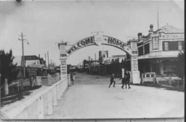
000522 Photograph - 1918 - McBride Avenue, Arch over path to Wonthaggi Railway Station “Welcome Home 1914-1918”
-
 Whitehorse Historical Society Inc.
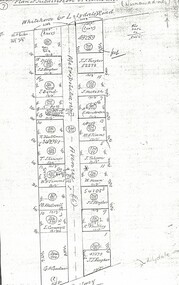
Document, Metropolitan Avenue, n.d
... and the railway in Nunawading. Metropolitan Avenue Document Document ...Plan of subdivision of 321.162 and 321.Plan of subdivision of 321.162 and 321.163 Metropolitan Avenue between Whitehorse (or Lilydale) Road and the railway in Nunawading.Plan of subdivision of 321.162 and 321.metropolitan avenue, nunawading, fargher, j.j., bond, j., bell, k., anderson, g., blackman, r., skinner, t., westwall, m., goodwin, george augustus, cornwall, i., hesketh, henderson, e., timms, m.a., tolson, horan, william, southey, land subdivision -
 Whitehorse Historical Society Inc.
Map, Plan, 1939
Plan of subdivision, part of crown portion 83A and 83, Parish of Nunawading, County of BourkePlan of subdivision, part of crown portion 83A and 83, Parish of Nunawading, County of BourkePlan of subdivision, part of crown portion 83A and 83, Parish of Nunawading, County of Bourkestreet names, parish of nunawading, station street, blackburn, railway road, blackburn, vine street, blackburn, south parade, blackburn, laburnum street, blackburn, main street, blackburn, gardenia street, blackburn, the avenue, blackburn, fuschia street, blackburn, linum street, blackburn -
 Whitehorse Historical Society Inc.
Document - Leaflet, Blackburn Land Sale, 19/11/1910 12:00:00 AM
Pamphlets showing sale of land Gardenia Street, Blackburn and surrounding streets.Pamphlets showing sale of land Gardenia Street, Blackburn and surrounding streets. Schedule of prices. Hand drawn mapPamphlets showing sale of land Gardenia Street, Blackburn and surrounding streets.blackburn township estate co. ltd., blackburn railway station, south parade blackburn, laburnum street, blackburn, the avenue blackburn, fuschia street blackburn, linum street blackburn, main street, t.r.b.morton. & son, land subdivision -
 Whitehorse Historical Society Inc.
Photograph, Railway Bridge, Brunswick Road, Heatherdale - Now Cochrane Street - runs through to Orient Avenue, C.1958
Black and white photo of Railway Bridge, Brunswick Road, Heatherdale.o'rourke, l. -
 Whitehorse Historical Society Inc.
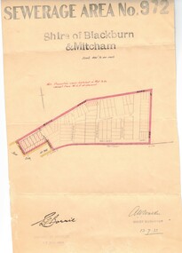
Document, Sewerage area, 13/07/1933 12:00:00 AM
Plan of sewerage area no. 972, Shire of Blackburn and Mitcham, scale 400' to an inch. 13 July 1933. Note that the area including Stuart Street on the map is now the Thiele Court area.sewerage and sanitation, shire of blackburn and mitcham, whitehorse road, blackburn, railway road, vine street, lithgow avenue, downing street, frankston street, stuart street, thiele court -
 Whitehorse Historical Society Inc.
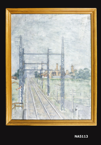
Painting - Framed oil painting, 1953
Looking East near Springvale Road Daniel Robertson ClayworksOil painting of Nunawading Railway station and clayworks.Railway Nunawading by J. B. Bryce 1953 and J. Bingley 22 Victoria Avenue, Canterbury 2816.daniel robertson, nunawading station -
 Ballarat Tramway Museum
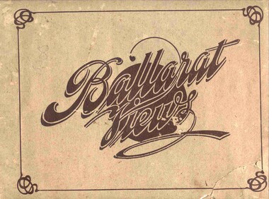
Book, Baxter & Stubbs, "Ballarat Views", 1920's
Yields information about Ballarat through pictures of the 1910-1920's various locations, institutions and street scenes, including tramways and railways.Twenty four page book within light brown covers, titled "Ballarat Views". Sheets, other than covers have been individually printed both sides, stapled within the covers. Cover - gives title, rear cover has printer details - Baxter and Stubbs. Pages 1 - Tonner Memorial , Fountain Lake Wendouree, Ballarat District Hospital, Sturt St south side at Grenville St with tram in distance and Sturt St North Side showing shops (image btm3900i2.jpg). 2 - Ballarat Street Scenes - Sturt Streets, Lydiard St with ESCo 18 in view, and Railway station with R193 in platform on passenger train. (image btm3900i3.jpg). 3 - Lake Wendouree views. 4 - Lake Wendouree, fish hatchery, Gardens and Sturt St at Dawson St (image btm3900i4.jpg). 5 - Art Gallery Ballarat 6 - Botanical Gardens 7 - Public Institution s- Benevolent asylum, Orphanage, Nazareth House, St Joseph Home, Hospital 8 & 9 - Statues, the Flight from Pompeii and others. 10 & 11 - Churches of Ballarat 12 - The Arch at The Avenue of Honour 13 - McDonald Pergola at the Gardens 14 - Zoological Gardens Ballarat 15 - Gardens aerial view and gates at the South End with tram in the distance (image btm3900i5.jpg). 16 - Some views in Ballarat East - Eureka Stockade, Ballarat East Bowling Green, Bridge St looking east and the lake at the Eureka Gardens (image btm3900i6.jpg). 17 - Snow Scene at Botanical Gardens, Begonia House 18 & 19 - Ballarat Water supply reservoirs 20 - Ballarat State Schools 21 - Ballarat East Views, includes view of track in Victoria St looking east (image btm3900i7.jpg). 22 - Views of the Water Reserves 23 - Views about the City - includes City fire station , agricultural High School, City Baths and View Point. 24 - Views at Lake Wendouree. \ Pdf copy of full book added 8/5/2019 - see btm3900i9.pdf trams, tramways, ballarat, lydiard st, sturt st, gardens, railway station, hospital, lake wendouree, wendouree parade, carlton st, esco -
 Ballarat Tramway Museum
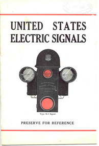
Book, The United States Electric Signal Co, "United States Electric Signals - Type K-2 Signal", 1920's?
Provides information about a system of safe working on a single line tramway or interurban railway or tram line. Has an illustration of the signal, coloured on the front cover. Gives details of the company, automatic electric block signals for 'railways' - interurban operation. The type K2-signal is one that can register up to 15 cars into and out of a section. Gives details, line diagrams and electrical details of this signal works, installation requirements and Trolley Contactors. Centre page has an electric diagram. Received by ESCo 4/11/1926.Yields information about a system on controlling vehicles on a single line railway or tramway section.Twenty page book, printed on art paper, centre page electrical diagram and light blue covers, titled "United States Electric Signals - Type K-2 Signal", with three centre staples. Noted by stamp on page 1 "Nachod and United States Signal Co. Inc. successors to the United States Electric Signal Co. 4771 - 4777 Louisville Avenue, Louisville Ky USA"The "Electric Supply Co. of Victoria 4/11/1926" in purple ink on the front cover, page 1and 5. On page 1 in black stamp ink "Nachod and United States Signal Co. Inc. successors to the United States Electric Signal Co. 4771 - 4777 Louisville Avenue, Louisville Ky USA" and on top of page 1 "Ballarat Tramway Preservation Society Catalogue No. 2" in black ink. On page 20 at bottom :From Nachod and United States Signal Co. Incorporated Louisville".trams, tramways, signals, railways, tramways -
 Ballarat Tramway Museum
Slide - 35mm slide/s, Glen Mills, Sept. 1971
White cardboard mount, 35mm slide, from the Association of Railway Enthusiast's film strip titled "Provincial Tramway Film Strip" of Tram 12 bound for Gardens, photographed across the median strip plantation near Dawson St. with St. Peters Church in the background. The film strip notes (Reg. Item 2560), provided the following caption details: "The wide Avenue of Sturt St. was the central spine of the Ballarat system -all routes traversed it for at least part of its length. Here No. 12 "GARDENS" bound, is seen through the foliage of the centre plantation in Sturt St. -Sept. '71 (Glen Mills)" See image btm2567p.tif for high level scan of image. Stamped on base of slide "11777" and written in ink on top edge "No. 12 Sturt St Ballarat"tramways, trams, are, film strip, sturt st, st peters, tram 12 -
 Ballarat Tramway Museum
Photograph - Colour Photograph/s - set of 13, Lloyd Rogers, 30/04/1989 12:00:00 AM
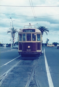
Yields information about the appearance of the operation of BTPS tram No. 661 in Melbourne on a tour.Set of 13 colour prints of BTPS / BTM tram No. 661 in Melbourne on a BTPS tour 30-4-1989. All photos by Lloyd Rogers, on AGFA paper. All have a photo number on rear and captions - see images 14 to 19. .1 - At Sth Melbourne Beach terminus. .2 - MMTB Paying fares dated Dec. 1968 in four languages inside tram. .3 - 661 and 878 at Brunswick Depot .4 - Y612 partly derailed at Brunswick .5 - 661, 8789 and 612 at Brunswick .6 - 661 at Batman Avenue .7 - Batman Avenue .8 - from the window looking forwards - reserved track. .9 - at South Melbourne Beach terminus with Bleak House in the background and an Advert for Swan Premium beer. .10 - ditto with Vopas Centre building in the background and an advert advertising Volvo motor cars - Swedish Lifesavers. .11 - ditto .12 - interior view of tram .13 - At Batman Ave with the shop on the railway side in the view.See images i14 to i19 for rear of photos.trams, tramways, melbourne, batman ave, brunswick depot, south melbourne beach, tram 661, tram 612, tram 878 -
 Australian Racing Museum
Racebook, Victoria Racing Club, 1946
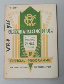
Un-numbered page race programme for the Victoria Racing Club Autumn Meeting First Day Saturday 2 March 1946. Front cover has a white background with green and white writing, and a green and yellow 1930s art deco design with the VRC insignia in the middle top. Back cover has a white background with green writing, and a yellow border, explaining the railway arrangements. -
 Buninyong & District Historical Society
Photograph - Photo of Original Photograph, Wal Larsen, B/W photo of enf of Buninyong Railway line at Learmonth St. in June 1940, June 1940
Railway station and surrounds in 1940.B/W photo of end of Buninyong Railway Line at Learmonth St. Shows old weighbridge, shifted from outside Town Hall in 1920's. Avenue of cypress trees which used to line Learmonth St. Taken 9 Jun 1940buninyong, railway, bunny, station, learmonth st., trees -
 Kew Historical Society Inc
Plan - Subdivision Plan, H C Crouch, Old Golf Links Estate, 1930s
The land in North Kew between the Outer Circle Railway and the River Yarra was released in sections. This release included 80 lots. Most of this area was released during the Depression years in the early 1930s.Subdivision plans are historically important documents used as evidence of the growth of suburbs in Australia. They frequently provide information about when the land was sold on which a built structure was subsequently constructed as well as evidence relating to surveyors and real estate and financial agents. The numerous subdivision plans in the Kew Historical Society's collection represent working documents, ranging from the initial sketches made in planning a subdivision to printed plans on which auctioneers or agents listed the prices for which individual lots were sold. In a number of cases, the reverse of a subdivision plan in the collection includes a photograph of a house that was also for sale by the agent. These photographs provide significant heritage information relating house design and decoration, fencing and household gardens.One part of a massive subdivision of the Old Golf Links Estate in North Kew of 80 allotments bordering Sutherland Avenue, Ramsay Avenue, Belford Road, Beresford Street and Coleman Avenue. Inset on the plan at the top left, the route of the Outer Circle Railway is clearly marked. The Kew Golf Links is identified in its current location. The land on which Greenacres Golf Club was to be constructed is at this time marked as ‘Recreation Ground’. The ‘new bridge’ over the Yarra at Burke Road is also marked on the inset map. The Plan identifies the surveyor (sic) H.C. Crouch BCE MVIS, 443 Little Collins St., Melbourne. The date of the subdivision auction sale in identified as Saturday September 25th at three o'clock.Annotations: "E" top left. "Golf Links" top right. Lots 73-76 ticked and listed as "6" poundssubdivisions -- kew (vic.), old golf links estate -
 Kew Historical Society Inc
Album - Scrapbook, Eva Grant, Historic Buildings, Kew, 1958-78, 1970s
One of three scrapbooks of photographs and newspaper cuttings taken and or collected by Eva Grant, a past member of the Kew Historical Society, which were donated by her niece, Julie Thomson. The albums include many photographs of Kew from the 1950s to the 1970s. Buildings included in the scrapbook include: Billy Hughes' house - 167 Cotham Road Congregational Church - Walpole Street (c.1978) Country Roads Board - Denmark Street (1960) Dorothy Rogers Reserve - Studley Park Road Ellsmere (also Ellesmere/Ellsmore) - Princess Street Field Place - 3 Henty Court Fernhurst - 13 Fernhurst Grove Kew Civic Centre (1959) Kew Junction (1958) Kew Railway Station (1902, 1959) Kew Recreation Hall - Wellington Street (1960) Neama (Hall) - Studley Park Road Southesk (formerly Ordsall) - Cotham Road (c.1960) St Anthony's Home for Babies (formerly Madford) - 43 Wellington Street (c.1976) Studley House - Nolan AvenueThe scrapbook contains historically significant, rare and sometimes unique images of significant heritage buildings in Kew, including their erection and demolition. 11-page scrapbook of photographs and newspaper clippings with annotations by Eva Grant, a past member of the Kew Historical Society. The pages of the album can be viewed in the image carousel above. Based on the text and known dates of demolition of a number of the buildings, the scrapbook was assembled over a twenty year period between c.1958-c.1978.Includes letter from donoreva grant, billy hughes' house - 167 cotham road, congregational church - walpole street - kew, country roads board - denmark street - kew, dorothy rogers reserve - studley park road - kew, field place - 3 henty court - kew (vic), ellsmere (also ellesmere/ellsmore) - princess street - kew, fernhurst - 13 fernhurst grove - kew (vic), kew civic centre - civic drive - kew (vic), kew junction - kew (vic), kew railway station - denmark street - kew (vic), recreation hall - wellington street - kew, neama - hall - studley park road - kew (vic), southesk - ordsall - cotham road- kew (vic), st anthony's home for babies - madford - 43 wellington street (vic), studley house - nolan avenue - kew (vic) -
 Kew Historical Society Inc
Plan - Subdivision Plan, Oswinia Estate, East Kew, c.1925
Prue Sanderson, in her groundbreaking ‘City of Kew Urban Conservation Study : Volume 2 - Development History’ (1988), summarised the periods of urban development and subdivisions of land in Kew. The periods that she identified included 1845-1880, 1880-1893, 1893-1921, 1921-1933, 1933-1943, and Post-War Development. These periods were selected as they represented periods of rapid growth or decline in urban development. An obvious starting point for Sanderson’s groupings involved population growth and the associated economic cycles. These cycles also highlighted urban expansion onto land that was predominantly rural, although in other cases it represented the decline and breakup of large estates. A number of the plans in the Kew Historical Society’s collection can also be found in other collections, such as those of the State Library of Victoria and the Boroondara Library Service. A number are however unique to the collection.Subdivision plans are historically important documents used as evidence of the growth of suburbs in Australia. They frequently provide information about when the land was sold on which a built structure was subsequently constructed as well as evidence relating to surveyors and real estate and financial agents. The numerous subdivision plans in the Kew Historical Society's collection represent working documents, ranging from the initial sketches made in planning a subdivision to printed plans on which auctioneers or agents listed the prices for which individual lots were sold. In a number of cases, the reverse of a subdivision plan in the collection includes a photograph of a house that was also for sale by the agent. These photographs provide significant heritage information relating house design and decoration, fencing and household gardens.The ‘Oswinia Estate’ subdivision in East Kew was planned and auctioned in the first half of the 1920s. 169 allotments were created in the triangular section of land bordered by High Street, Burke Road and the Government Boulevard (later Kilby Road). The only piece of land excluded was that where the previous Kew Pound had been located at the east tip of the triangle. Allotments were created fronting Glass, High, Namur, Oswin Streets, Irymple Avenue, and the Government Boulevard. The name for the Estate was derived from Oswin’s farm, which had been one of the largest landholdings in East Kew. The selling agents annotated the plan in our collection with crosses indicating those lots that had been sold. The inset locality plan is particularly interesting as it shows the route and stations of the Outer Circle Railway. When the subdivision plan was created, it included the proposed bridge over the Yarra at Burke Road. The bridge was to be officially opened in 1926.subdivision plans - east kew, oswinia estate, high street, glass street, namur street, government boulevard - kilby road, irymple street, oswin street