Showing 113043 items
matching road
-
 Vision Australia
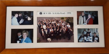
Photograph (item) - Image, Staff at RVIB St Kilda Road - 1998
Five photographs of groups of staff members at RVIB. Image 1 - Maree Littlepage, Christine Harding, ?? Image 2 - ? and Sandie Mackevicius Image 3 - Group photograph in driveway: Blue letters: A - Chris Headland, B - Barbara Williams, C - Ramona Mandy, D - Barbara Royce, E – Tess Rousso, F – Robyn Gale, G – Peter Cronin, H – Chris Edwards, I – Glen Morrow, J – Graeme Craig, K – Barbara McKenzie, L – Marg Harvey, M – Judy Williams, N – Len Stephens, O – Nina Sutton, P – Sherry Cunningham, Q – Marissa Depitta, R – Uli Pfisterer, S – Rosemary, T – Maree Sheehan, U – Linda Rivette, V – Rachel Grealy, W – Fiona Pelusi, X – Maree Littlepage, Y – Danielle, Z – Sophie Tzoukalis. (Between Pelusi and Stephens, Christine Harding. Green letters: A – Emma Rogers-Wilson, B – Rory Fraser, C – Gary Stinchcombe, D – Alex Zolradkovic, E – Nicola Misso, F – Mary Barron, G – Barbara, H – Kathy Lazzaro, I – Linda Morris, J – Pam McAleese. Image 4 - ?? Image 5 - Robyn Gale, ??RVIB - St Kilda Road - 1998royal victorian institute for the blind, staff -
 Southern Sherbrooke Historical Society Inc.
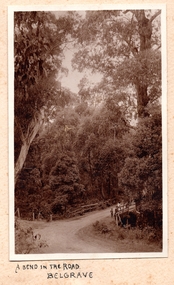
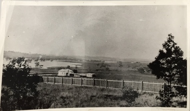
Photograph, A Bend In The Road, Belgrave, c. 1920s
Photo shows a bend in the road, Belgrave, most likely on Monbulk Road below Sherbrooke Forest. An unmade road crosses a small gully. A group of three or so young people are leaning over the bridge railing. The area is heavily treed. A BEND IN THE ROAD hand-wriiten in ink below the photo on the album page -
 Warrnambool and District Historical Society Inc.
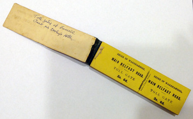
Certificate - Ticket Book, Main Belfast Road Toll, 2s 6d, 1860s
The Shire of Warrnambool operated toll gates from 1866 to 1869 as a means of revenue rai sing for road construction. There were three toll gate locations – on the main Belfast (Port Fairy) Road at Dennington Bridge, on the Woodford Road at Russells Creek and on the Geelong Road at the Allansford Bridge. The toll gates were unpopular and unprofitable for the lessees as travellers were able to avoid the tax by skirting around the gates. They had toll houses besides the gates. The printers of these tickets, Fairfax and Laurie were the lessees at the time of the Warrnambool Examiner newspaper. This paper, founded by Richard Osburne and John Wilkinson, and published with some gaps from 1851 to 1880, is a key source today of Warrnambool’s history at that time. These toll gates tickets are significant because:- 1. They date back to the 1860s and were only issued from 1866 to 1869. 2. They are the only artefacts we hold of the time when toll gates were operating in our local district 3. They are the best example of how the Shire of Warrnambool in its early history raised revenue for road building and maintenance This is a book of toll gate tickets for sale at the Main Belfast (Port Fairy) Road Toll Gate. The tickets (about 50) are yellow and in duplicate with provision to detach the outer ticket for the purchaser to keep. The tickets (two shillings and sixpence) are bound with an adhesive tape and the cover is mottled in pattern (brown and blue). There are also four loose tickets in blue (3 shillings). Back Cover: ‘136’ Tickets in book: ‘Shire of Warrnambool, Main Belfast Road, Toll Gate 2s 6d., Fairfax and Laurie, Printers’ Loose tickets: ‘Shire of Warrnambool, Main Belfast Road, Toll Gate, 3s.’ shire of warrnambool, toll gates -
 St Kilda Historical Society
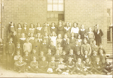
Photograph, St Kilda (Brighton Road)Primary School
Unable to read date in photograph but children's clothing suggests early 1900ssepia photograph mounted fair conditionSt Kilda (Brighton Road)Primary School. (?) Thomeson (?). 721 South Road, Moorabbin. Donated to the Historical Society. -
 Whitehorse Historical Society Inc.
Newspaper - Article, 575 Canterbury Road, Vermont, 3/08/1994
Canterbury Road, Vermont. Article on late 1950 weatherboard home at 575 Canterbury Road, Vermont.canterbury road, vermont, no 575 -
 Surrey Hills Historical Society Collection
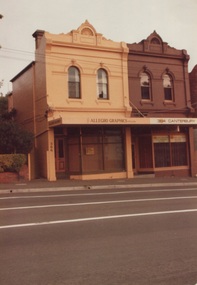
Photograph, 386-384 Canterbury Road Surrey Hills
The donor, Bob Lennox believed that these were the work of his great-grandfather William Lennox and his builders. William and his son were plasterers and often used the shell motif which is seen on the pediment of the buildings. These two terraces were part of the retail development of five terraces along Canterbury Road which were constructed on land subdivided from the parcel of land originally owned by John Woodhead. The Alan Holt register of properties in 3127 gives a list of proprietors / residents at the beginning of each decade from 1890-1980. There are also earlier photos depicting these buildings in the collection. These buildings have been included in the City of Boroondara Heritage Overlay Union Road Commercial Precinct 2011, Surrey Hills.These buildings were amongst the first commercial buildings serving the area of Surrey Hills and followed the extension of the railway from Camberwell in 1883.A colour photo with rounded corners taken from slightly diagonally across Canterbury Road from 2 double-storey Victorian style buildings. Both have the decorative shell motif in the pediment.Back of photo in green pencil "CANTERBURY RD SURREY HILLS / EAST OF UNION RD"victorian style, allegro graphics, william lennox, 386-384 canterbury road, shops, victorian terraces, canterbury road, surrey hills, john woodhead, heritage overlay union road commercial precinct 2011, heritage overlays -
 Kew Historical Society Inc
Photograph, Stuart Tompkins Studio, Electricity Supply Poles, Burke Road, Kew, 1965
Research provided by Stuart Tompkins Studio, Box Hill, into alternatives for median strip street lighting to be used in Burke Road, Kew. The photographers identified variants in different suburbs appropriate to Kew's needs.The series from which the photograph is drawn provides a snapshot by a commercial photographic studio of each named vicinity in 1965 as well as providing examples of public works infrastructure being commissioned by local government in the 1960s. The photos originally formed part of the Engineering Department's files in the City of Kew before being donated to the kew Historical Society.Electricity Supply Poles, Burke Road, Kew, 1965. This photograph of Burke Road, Kew was taken just north of Kilby and Doncaster Roads looking north. Stuart Tompkins Studio provided the photograph for the Kew City Council. In the photograph are a number of electricity supply poles that have been erected in the median strip, in addition to some new poles on each footpath. The nearest wooden pole is stated to be 13.5″ in diameter. The electricity poles in Burke Road required Kew Council to investigate comparable designs in other Melbourne municipalities. [There are three copies of this photograph in the Collection.] Typed inscription on reverse: "Electricity Supply Poles. Photographed for Kew City Council 8/2/65. No.5 Burke Road - Kew, just north of Kilby and Doncaster Roads looking north. Some of seven poles already erected in median strip. Shows also some new poles erected on each footpath. Nearest wooden pole 13 1/2" dia." Studio stamp: "Stuart Tompkins Studio. 547 Station Street, Box Hill. WX1439."stuart tompkins studio, street lighting, south road (moorabin) 1965 -
 Melbourne Tram Museum
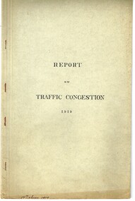
Document - Report, Road Board, "Report on Traffic Congestion", 1919
Report - 26 pages, printed, contained and stapled within a grey "Roneo Numeralpha System" folder, titled "Report on Traffic Congestion", containing a Victorian Parliamentary Report, dated 1919 with titled "Report of Board appointed to investigate the problem of relieving congestion of traffic in Melbourne." Full title "Report of Board Appointed to Investigate the problem of Relieving Congestion of Traffic in Melbourne" The Board or "Traffic Board" comprised 5 representatives of Councils, MMTB, Railways and the Public Works Department includes comments on growth of Melbourne, railways, tramways, new arterial roads, subways, new bridge at Spencer St, regulation of street traffic, looks at new tramway routes, hours works and provides a summary of recommendations including drawings for new arterial roads, graphs and roads / tramway layouts in two chain wide roads. Note: This document is available as a pdf on the Parliament of Victoria website. Second copy - unbound as printed, stapled on the left hand side, from McComb collection, box 10 - added 5/1/2017. added a 2nd copy from Russell Jones (28/05/22). Poor quality copy.Has in ink on the bottom edge "17th June 1919", Copy 2 - "H. Lormer"? in ink in the top right hand corner.trams, tramways, mmtb, general scheme, tramways, development, parliament, spencer st, railways, finances, construction, traffic control -
 Camberwell Historical Society
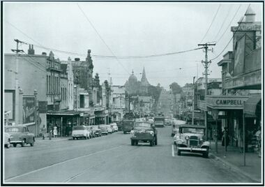
Photograph, Camberwell, Victoria, view of Burke Road and stores, c. 1950
Print of photograph looking south down Burke Road with St Johns Anglican church tower in the background. Inscription 'Camberwell, Victoria, view of Burke Road and stores c. 1950' Camberwell, Victoria, view of Burke Road and stores c. 1950camberwell -
 Bendigo Military Museum
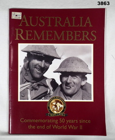
Book - BOOK, 50 YEARS, The Open Road, Australia Remembers, 1995
Australia Remembers 1945 - 1995. Commemorating 50 years since the end of World War II.Soft cardboard cover. Gold print on front / back over dark red background. Illustrated front / back & white photo of 2 uniformed soldiers. Black / white photo of a crowd scene on back. 80 cut, plain, glossy white pages. Illustrated black / white / sepia / colour photos, porters, paintings & drawings.book, remembers, 50 years, 1945 - 1995 -
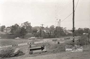
 Ringwood and District Historical Society
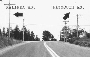
Photograph, Intersection of Kalinda Road and Plymouth Rd. Ringwood 1967
B&W Photograph with road names and arrows added.Catalogue card reads, "Intersection of Kalinda Road and Plymouth Rd. 1967". -
 Eltham District Historical Society Inc
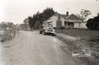
Photograph, Sherbourne Road, Para Road and Simms Road at Briar Hill, 3 November 1967, 3 Nov 1967
Viewed from Simms Road in front of Mrs Cameron's house in what is now the northwest bound lanes of Para Road prior to the roundabout intersedction with Sherbourne Road. Simms Road is running to the right in front of the old house. The house belongs to Mrs Cameron whose daughter married a DAVEY after which Davey Street is named. Excavation work is being undertaken for the realignment of the Para Road and Sherbourne Road intersection where the current roundabout is located, approximately where the two cars are parked. Mrs Cameron's house and the other are where Montmorency Secondary College is situated. The school opened in 1969.Roll of 35mm black and white negative film, 6 strips Ilford HP3briar hill, cameron, davey, davey road, graham body works, greensborough, montmorency secondary college, sherbourne road, simms road -
 Eltham District Historical Society Inc
Photograph, Sherbourne Road, Para Road and Simms Road at Briar Hill, 3 November 1967, 3 Nov 1967
Viewed from Simms Road in front of Mrs Cameron's house in what is now the northwest bound lanes of Para Road prior to the roundabout intersedction with Sherbourne Road. Simms Road is running to the right in front of the old house. The house belongs to Mrs Cameron whose daughter married a DAVEY after which Davey Street is named. Excavation work is being undertaken for the realignment of the Para Road and Sherbourne Road intersection where the current roundabout is located, approximately where the two cars are parked. Mrs Cameron's house and the other are where Montmorency Secondary College is situated. The school opened in 1969.Roll of 35mm black and white negative film, 6 strips Ilford HP3briar hill, cameron, davey, davey road, graham body works, greensborough, montmorency secondary college, sherbourne road, simms road -
Whitehorse Historical Society Inc.
Newspaper - Article, 134 Central Road, Blackburn, 10/03/1988
Advertisement for auction of 134 Central Road, Blackburn by Noel Allen, with newspaper article re 134 Central Road.central road, blackburn, boyd, robin, auctions -
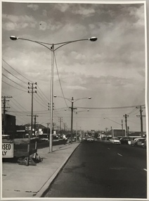 Kew Historical Society Inc
Photograph, Stuart Tompkins Studio, Electricity Supply Poles, South Road, Moorabbin, 1965
Research provided by Stuart Tompkins Studio, Box Hill, into alternatives for median strip street lighting to be used in Burke Road, Kew. The photographers identified variants in different suburbs appropriate to Kew's needs.The series from which the photograph is drawn provides a snapshot by a commercial photographic studio of each named vicinity in 1965 as well as providing examples of public works infrastructure being commissioned by local government in the 1960s. The photos originally formed part of the Engineering Department's files in the City of Kew before being donated to the kew Historical Society.Electricity Supply Poles, South Road, Moorabbin, 1965. Stuart Tompkins Studio provided this photograph for the Kew City Council. The photograph of South Road, Moorabbin, west of Jasper Road, looking east depicts steel poles with two lamps in a median strip and supply wires from pole to pole. The poles were described as 100′ apart. The notation on the rear of the photograph was that there were lamps along the median strip except at intersections. A wooden pole is recognised as supporting heavy supply lines across the road. The steel poles in the photograph were said to be between 3′ to 3.5′ whereas the wooden poles were three to 12.25″ in diameter. [There are three copies of this photograph in the Collection.] Typed inscription on reverse: "Electricity Supply Poles. Photographed for Kew City Council 8/2/65. No.2 South Road - Moorabbin, west of Jasper Road, looking east. Steel poles with two lamps in median strip and supply wires from pole to pole along median strip (poles only 100' apart). Lamps along median only except at intersections. Wooden pole supports heavy supply lines across the road. Wooden poles 3' up and 8 1/2" dia. Wooden poles 3' up and 12 1/2 dia." Studio stamp: "Stuart Tompkins Studio. 547 Station Street, Box Hill. WX1439."public infrastructure -- kew (vic.), city of kew - engineers department -
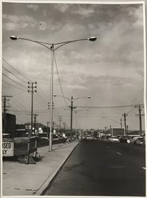 Kew Historical Society Inc
Photograph, Stuart Tompkins Studio, Electricity Supply Poles, South Road, Moorabbin, 1965
Research provided by Stuart Tompkins Studio, Box Hill, into alternatives for median strip street lighting to be used in Burke Road, Kew. The photographers identified variants in different suburbs appropriate to Kew's needs.The series from which the photograph is drawn provides a snapshot by a commercial photographic studio of each named vicinity in 1965 as well as providing examples of public works infrastructure being commissioned by local government in the 1960s. The photos originally formed part of the Engineering Department's files in the City of Kew before being donated to the kew Historical Society.Electricity Supply Poles, South Road, Moorabbin, 1965. Stuart Tompkins Studio provided this photograph for the Kew City Council. The photograph of South Road, Moorabbin, west of Jasper Road, looking east depicts steel poles with two lamps in a median strip and supply wires from pole to pole. The poles were described as 100′ apart. The notation on the rear of the photograph was that there were lamps along the median strip except at intersections. A wooden pole is recognised as supporting heavy supply lines across the road. The steel poles in the photograph were said to be between 3′ to 3.5′ whereas the wooden poles were three to 12.25″ in diameter. [There are three copies of this photograph in the Collection.] Typed inscription on reverse: "Electricity Supply Poles. Photographed for Kew City Council 8/2/65. No.2 South Road - Moorabbin, west of Jasper Road, looking east. Steel poles with two lamps in median strip and supply wires from pole to pole along median strip (poles only 100' apart). Lamps along median only except at intersections. Wooden pole supports heavy supply lines across the road. Wooden poles 3' up and 8 1/2" dia. Wooden poles 3' up and 12 1/2 dia." Studio stamp: "Stuart Tompkins Studio. 547 Station Street, Box Hill. WX1439."city of kew -- engineers department, public infrastructure -- kew (vic.) -
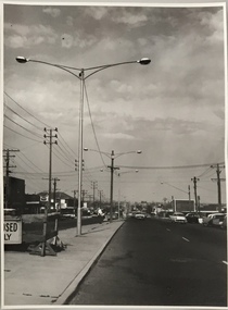 Kew Historical Society Inc
Photograph, Stuart Tompkins Studio, Electricity Supply Poles, South Road, Moorabbin, 1965
Research provided by Stuart Tompkins Studio, Box Hill, into alternatives for median strip street lighting to be used in Burke Road, Kew. The photographers identified variants in different suburbs appropriate to Kew's needs.The series from which the photograph is drawn provides a snapshot by a commercial photographic studio of each named vicinity in 1965 as well as providing examples of public works infrastructure being commissioned by local government in the 1960s. The photos originally formed part of the Engineering Department's files in the City of Kew before being donated to the kew Historical Society.Electricity Supply Poles, South Road, Moorabbin, 1965. Stuart Tompkins Studio provided this photograph for the Kew City Council. The photograph of South Road, Moorabbin, west of Jasper Road, looking east depicts steel poles with two lamps in a median strip and supply wires from pole to pole. The poles were described as 100′ apart. The notation on the rear of the photograph was that there were lamps along the median strip except at intersections. A wooden pole is recognised as supporting heavy supply lines across the road. The steel poles in the photograph were said to be between 3′ to 3.5′ whereas the wooden poles were three to 12.25″ in diameter. [There are three copies of this photograph in the Collection.] Typed inscription on reverse: "Electricity Supply Poles. Photographed for Kew City Council 8/2/65. No.2 South Road - Moorabbin, west of Jasper Road, looking east. Steel poles with two lamps in median strip and supply wires from pole to pole along median strip (poles only 100' apart). Lamps along median only except at intersections. Wooden pole supports heavy supply lines across the road. Wooden poles 3' up and 8 1/2" dia. Wooden poles 3' up and 12 1/2 dia." Studio stamp: "Stuart Tompkins Studio. 547 Station Street, Box Hill. WX1439."stuart tompkins studio, street lighting, south road (moorabin) 1965, public infrastructure -- city of kew, city of kew -- engineer's department -
 Clunes Museum
Photograph, BALLARAT ROAD, CLUNES, SOUTH WEST, 1865
PHOTOGRAPH SHOWS MANSE PREBYTERIAN [ST ANDREWS[ CHURCH METHODIST [WESLEY[ WITHOUT SPIRE, SUNDAY SCHOOL AND PARSONAGE MARKET, POST OFFICE SITE TOWN HALL PHOTOGRAPH OF BALLARAT ROAD [SERVICE STREET] CLUNES. PHOTOGRAPH TAKEN FROM GEORGE STREET TOWARDS SMEATON ROAD. .1 SEPIA PHOTOGRAPH MOUNTED, WITH POINTS OF INTEREST NOTED AROUND EDGE. PERIOD 1865 .2 BLACK AND WHITE PHOTO PRINT .3 SMALL BLACK AND WHITE PHOTO PRINTBALLARAT ROAD, CLUNES, SOUTH WESTphotography, photographs, township, churches -
Whitehorse Historical Society Inc.
Article, Springvale Road tops accident list, 2004
An interview with Ken Ogden of the RACV identifies Springvale Road as the road most likely to have car accidents in Melbourne.An interview with Ken Ogden of the RACV identifies Springvale Road as the road most likely to have car accidents in Melbourne. Included in the worst five corners are those with Whitehorse Road and Canterbury Road.An interview with Ken Ogden of the RACV identifies Springvale Road as the road most likely to have car accidents in Melbourne. road accidents, royal automobile club of victoria, whitehorse road, nunawading, springvale road, nunawading, springvale road, forest hill, canterbury road, forest hill -
 Surrey Hills Historical Society Collection
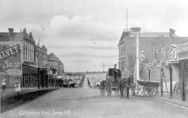
Work on paper - Photograph, Canterbury Road, near the corner of Union Road, 1911
J A Geer's grocery store operated from 1909-1912 on the site established by George Sim in 1884. He bought a house and added a shop where, in 1889, he established the first post office in the area. Prior to this residents had to go the Box Hill to collect mail. Date is approximate.This records one of the earliest businesses in Surrey Hills. To begin with, businesses developed along Canterbury Road rather than Union Road, in part because of the muddy nature of the land north of the railway line.Black and white photo taken from a postcard of Canterbury Road, near the corner of Union Road, looking west in 1906 or 1907. Two children play on the LHS of the street and there is a man on a horse and carriage, and a cart, on the RHS. Buildings on the RHS are the Surrey Family Hotel and J A Geer's grocery store; on the LHS is a row of double-storey terraces including Hansen's Terrace on Canterbury Road to the west of Union Road.On LHS within the original image is 'Canterbury Road, Surrey Hills'; on the rear in top LH corner in blue biro in Jocelyn Hall's handwriting "J H / spare"canterbury road, geer's grocery store, surrey family hotel, businesses, horse drawn vehicle, hansen's terrace, post card, mr j a geer -
 National Wool Museum
Uniform - Shirt, Country Road, c.2000
Australian shirt from the Sydney 2000 Olympic Games unisex casual uniform (option 2). Designed by Country Road.Blue and white tatterstall shirt with 2000 Australian Olympic emblem on right breast pocket. AUSTRALIA SYDNEY 2000fashion, woolmark company country road, sport, the woolmark company 2000 australian olympic display - exhibition (21/12/2001 - 24/05/2002), sydney 2000 olympic games -
 National Wool Museum
Uniform - Jacket, Country Road, Sydney 2000 Olympic Games Australian Unisex Casual Jacket, c.2000
Australian jacket from the Sydney 2000 Olympic Games unisex casual uniform (option 1). Designed by Country Road.Cream collared jacket with zip. Australian Sydney Olympics emblem embroidered on right breast. SYDNEY 2000fashion, woolmark company country road, sport, the woolmark company 2000 australian olympic display - exhibition (21/12/2001 - 24/05/2002), sydney 2000 olympic games -
 National Wool Museum
Clothing - Suit Jacket, Suit Pants and Tie, Flair, 1980s
Navy blue pinstripe suit jacket and pants. Charcoal tie with a tan geometric print. Printed [inside jacket tag]: Flair / COOL / WOOL / WARM IRON / DRY CLEAN ONLY / PURE NEW WOOL Printed [tie label]: Country Road Australia / Made in Italy Printed [pants label] No. 9722fashion, wool, men's suit, clothing, fabric, australian made, tie, pants, jackets, design, textile -
 Whitehorse Historical Society Inc.
Photograph, Deep Creek Road Bridge, 18/04/2001 12:00:00 AM
Coloured photograph looking East from Deep Creek Road Bridge at start of construction of new Deep Creek Road Bridge.deep creek road, mitcham, vicroads -
 Kew Historical Society Inc
Photograph, Kilby Road, North Kew, 1916
Kilby Road, North Kew 1916. Annotation Reverse: "Kilby Road about 1916. Courtesy Mrs E. Bennett, Kew East."north kew, farming (kew), wade's farm (kew) -
 National Wool Museum
Uniform - T-shirt, Country Road, Sydney 2000 Olympic Games Casual Australian Uniform, c.2000
Australian t-shirt from the Sydney 2000 Olympic Games unisex casual uniform (option 1). Designed by Country Road.White T-Shirt with Australian emblem and Sydney 2000 Olympic logo on left sleeve. AUSTRALIA SYDNEY 2000fashion, woolmark company country road, sport, the woolmark company 2000 australian olympic display - exhibition (21/12/2001 - 24/05/2002), sydney 2000 olympic games -
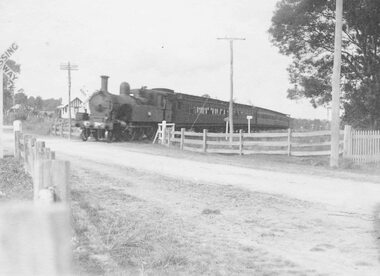 Ringwood and District Historical Society
Photograph, Railway crossing, Bedford Road, Ringwood - c1925 2 copies, 1925
Steam train at Bedford Road railway crossing, Ringwood. Ferntree Gully line.Written above photograph, "Bedford Road railway crossing - c1925". -
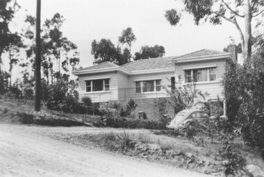 Ringwood and District Historical Society
Photograph, No 12 Glenvale Road, North Ringwood. 1964, 1964
House in Glenvale Road (2 views). See also #2936-2939 for views of Glenvale Road taken at the same time.Written on back of photographs, "1964 - 12 Glenvale Road. Original supplied by Garrett Gundry." (2 views) -
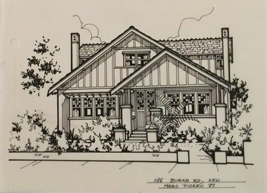 Kew Historical Society Inc
Drawing - Property Illustration, Margaret Picken, 1185 Burke Road, Kew, 1997
After training as a Cartographic Draftsman within the mining industry, I worked as a property illustrator for real estate firms in the eastern suburbs of Melbourne for 23 years from 1983. I initially photographed houses with a Polaroid camera and made a 'thumbnail' sketch while there. The photos were used to scale off a sketch in pencil and then that sketch was overlaid with drafting film and the 'pen and ink' completed. The pens I used were the Rotring ‘Rapidigraph’ drafting pens. The ink was also made by Rotring (German).The film was ‘Rapidraw’, polyester drafting film, double matte. It takes a very fine line and doesn’t bleed. As well as house sketches, there were often floor plans and site plans ordered. Aerial sketches were ordered when the property needed an overall view. (Margaret Picken, 2020)This drawing is one of a series created by Margaret Picken for a range of real estate agents in Melbourne between c.1983 and c.2005. Each work is signed and dated by the artist.Gift of Margaret Picken, 2020Pen and ink architectural drawing on drafting film of 1185 Burke Road, Kew by Margaret Picken.1185 BURKE ROAD., KEW / MARG PICKEN '97artist -- margaret picken 1950-, architectural drawings -- houses -- kew (vic.), 1185 burke road -- kew (vic.)