Showing 3153 items
matching south west
-
 Ringwood and District Historical Society
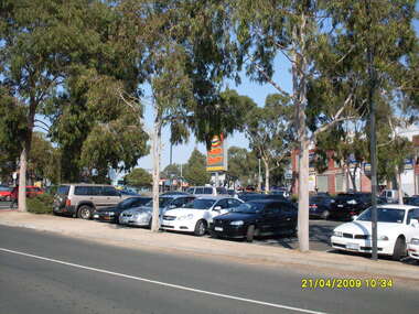
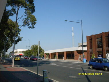
Photograph, Looking across stage 4 Eastland carpark, towards the south-west, on 21 April 2009. Showing Ringwood Railway Station across Maroondah Highway
... Looking across stage 4 Eastland carpark, towards the south... stage 4 Eastland carpark, towards the south-west, on 21 April ...Ron Brons photographic study of Ringwood. -
 Ringwood and District Historical Society
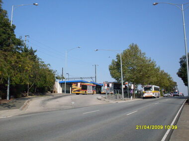
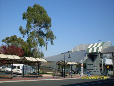
Photograph, Looking south south-west on Maroondah Highway, on 21 April 2009, showing bus terminus entrance
... Looking south south-west on Maroondah Highway, on 21 April... south-west on Maroondah Highway, on 21 April 2009, showing bus ...Ron Brons photographic study of Ringwood. -
 Ringwood and District Historical Society
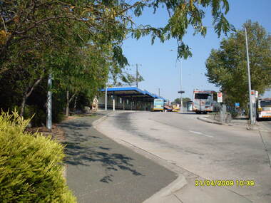
Photograph, Looking across Maroondah Highway towards the south-west, on 21 April 2009. Showing entrance to Ringwood bus terminus
... Looking across Maroondah Highway towards the south-west, on... Maroondah Highway towards the south-west, on 21 April 2009. Showing ...Ron Brons photographic study of Ringwood. -
 Ringwood and District Historical Society
Photograph, Ringwood Street looking south-west, Ringwood on 21 April 2009. Former Post Office on right
... Ringwood Street looking south-west, Ringwood on 21 April... looking south-west, Ringwood on 21 April 2009. Former Post Office ...Ron Brons photographic study of Ringwood -
 Ringwood and District Historical Society
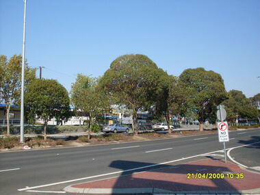
Photograph, Taken from Eastland access road looking south-west, on 21 April 2009. Showing library and pedestrian walk and crossing
... Taken from Eastland access road looking south-west, on 21... Eastland access road looking south-west, on 21 April 2009. Showing ...Ron Brons photographic study of Ringwood. -
 Ringwood and District Historical Society
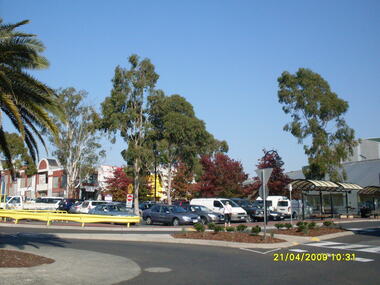
Photograph, Looking along Eastland access road towards the south-west, on 21 April 2009. Showing pedestrian crossing to south car park and shops
... Looking along Eastland access road towards the south-west... Eastland access road towards the south-west, on 21 April 2009 ...Ron Brons photographic study of Ringwood. -
 Clunes Museum
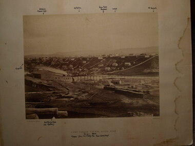
Photograph, CAMP PARADE, C. 1865
... .1 SEPIA PHOTOGRAPH CAMP PARADE, CLUNES, SOUTH WEST TAKEN...CAMP PARADE CLUNES, SOUTH WEST... PARADE CLUNES, SOUTH WEST .1 SEPIA PHOTOGRAPH CAMP PARADE, CLUNES ....1 SEPIA PHOTOGRAPH CAMP PARADE, CLUNES, SOUTH WEST TAKEN FROM PORT PHILIP HILL, NEAR NORTH SHAFT. PERIOD; 1865 MOUNTED ON CARD .2 LARGE BLACK AND WHITE COPY .3 SMALL BLACK AND WHITE COPY .4 MOUNTED PHOTO PRINT OF CAMP PARADE CAMP PARADE CLUNES, SOUTH WESTphotographs, mining, camp parade, port phillip hill -
 Clunes Museum
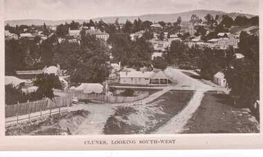
Photograph, AJAX SERIES
... VIEW OF CLUNES LOOKING SOUTH - WEST... SOUTH WEST... OF CLUNES LOOKING SOUTH - WEST local history document postcard plus ...VIEW OF CLUNES LOOKING SOUTH - WEST.1 POSTCARD SIZE BLACK AND WHITE PHOTOGRAPH SHOWING OVERALL VIEW OF CLUNES WITH MT. BECKWORTH IN THE BACKGROUND. PHOTOGRAPH TAKEN FROM TOP OF CAMERON STREET HILL .2 BLACK AND WHITE COPY OF ABOVE .3 BLACK AND WHITE COPY OF ABOVE PRINTED ON PHOTOGRAPHIC PAPEROn front of postcard in black printing; CLUNES LOOKING SOUTH WESTlocal history, document, postcard plus 1 copy, clunes township -
 B-24 Liberator Memorial Restoration Australia Inc
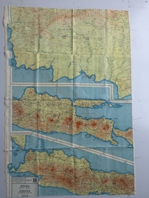
Map - British World War II silk map of Sumatra (South) and Java (Extreme North West), 1944
... on rayon, 1944 Series South West Pacific Area (SWPA) and Asia ...Sheet G Sumatra (South) and Java (Extreme North West... (Extreme North West) and, on the reverse, Sheet H Borneo (South ...Silk and rayon maps were produced by Great Britain (some 1.75 million in total), the United States (c.7.5 million) and Australia during World War II. They were issued to Allied military personnel as part of 'escape and evasion' kits.This map, printed on rayon, is an original British 'escape and evasion' kit map from World War II.A multi-coloured, contoured, double-sided map printed on rayon, 1944 Series South West Pacific Area (SWPA) and Asia Sheet G Sumatra (South) and Java (Extreme North West) and, on the reverse, Sheet H Borneo (South West), Java and Sumatra (Extreme South)world war ii, silk maps, great britain, a187 -
 Port Fairy Historical Society Museum and Archives
Photograph
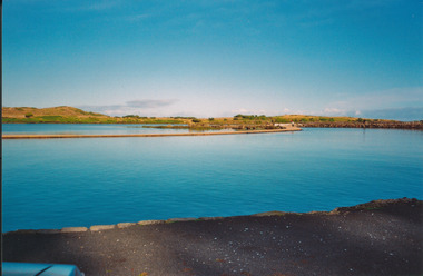
... South west passage...South West Passage Port Fairy... Street Port Fairy great-ocean-road South West Passage Port Fairy ...South West Passage Port Fairysouth west passage, training walls, tide -
 Warrnambool and District Historical Society Inc.
Book, Star Printing Terang Victoria. 978-0-9751360-1-0 et al, The Road to Laurel-Dale, Nov 2014
... guinea families of south west victoria... of Laang and south west Victoria. It celebrates 160 years since... of Laang and south west Victoria. It celebrates 160 years since ...Early Bennett, Buck & Guinea families in Laang & South West VictoriaThis is a soft cover book of 340 pages. It has a grey cover with a black and white sketch of a house on the front and a black and white photograph of a house on the back. There is black printing on the front and the back and the spine of the cover. The book has an introduction, acknowledgements and contents pages, information on the Bennett, Buck and Guinea families, a bibliography and an index. There are many maps, black and white photographs and illustrations and family trees. There are several blank pages at the back of the book for the inclusion of family records and information. non-fictionEarly Bennett, Buck & Guinea families in Laang & South West Victorialaang, guinea families of south west victoria, bennett families of south west victoria, buck families of south west victoria, history of warrnambool -
 Port Fairy Historical Society Museum and Archives
Photograph
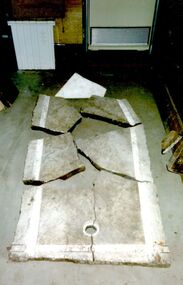
... and the water was pumped across from the South West Passage via...Cox Street, Port Fairy, South West, Victoria, Australia... sea baths and the water was pumped across from the South West ...The marble shown in this photograph was collected by Mr Leo Brady from the Bank Street site of the Public Baths that were built there in the late 1800’s. These were sea baths and the water was pumped across from the South West Passage via a windmill.This is was all that remained of the public sea baths. The Historical Society also has two small pieces of marble and a long bolt that held the marble togetherColoured photograph of the broken marble base of one of the baths at the Public Bathsemployee, industry, marble, public baths, leo brady, bank street -
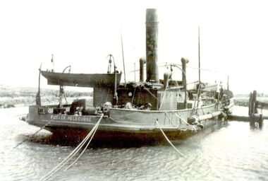 Port Fairy Historical Society Museum and Archives
Photograph
... south west passage... the Moyne river caused by the South West passage sweeping through... in to clear sand drift from the Moyne river caused by the South West ...The Dredge 'Pioneer' brought in to clear sand drift from the Moyne river caused by the South West passage sweeping throughBlack and white photograph of a dredge in Moyne riversea, river, moyne river, south west passage, pioneer, deredge, ship -
Glenelg Shire Council Cultural Collection
Programme, Discovery, Portland, 2008
... Great South West Walk... of Great South West Walk depicting four movements of symphony... 2008. music performance Great South West Walk symphony ...World premiere of 'Discovery' performed at Portland Civic Hall, Saturday August 2nd 2008.A4 size, 12 page programme for the world premiere performance of Choral Symphony 'Discovery' at Portland 2nd August 2008. Back and front covers glossy white card. Images of 4 areas of Great South West Walk depicting four movements of symphony, on front cover. Back cover major sponsors and partners.music, performance, great south west walk, symphony, orchestra -
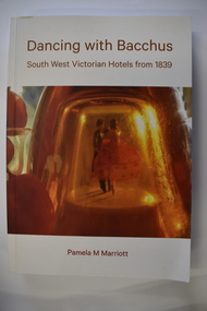 Warrnambool and District Historical Society Inc.
Book, Pam Marriott (publisher), Dancing With Bacchus, 2021
... Hotels in South West Victoria... information on hotels in South West Victoria from 1839. It includes... information on hotels in South West Victoria from 1839. It includes ...This book contains information on South West Victorian hotels from 1839This is a soft cover book of 348 pages. The cover has a white background with gold-coloured print, a red and orange image of dancers on the front cover and a photograph of liquor bottles and grapes on the back cover. The book contains a foreword, an index, printed text and black and white photographs.non-fictionThis book contains information on South West Victorian hotels from 1839 hotels in south west victoria, warrnambool history -
Glen Eira Historical Society
Document - Grange Road, 77, Glen Huntly
... Road, south west corner with Neerim Road, then in the suburb...Grange Road, south west corner of Neerim Road, Glen Huntly... Road, south west corner with Neerim Road, then in the suburb ...This file contains one item about the sale and history of the then unnumbered property and the first owners of the home at 77 Grange Road, south west corner with Neerim Road, then in the suburb of Carnegie: 1/ A typed sheet with the details and documents that were given to the society in 1987. These are biographical details provided by the son of Hulbert Gorrie, a Chemist who worked at Rankin and Eyval Chemists shop at 165 Glenhuntly Road (from around 1920 to 1957). Hulbert and his wife Gertrude Gorrie purchased the vacant block and built the first house at the address in 1936. The photo mentioned of Hulbert at the shop is held in our file 1080A Glenhuntly Road Elsternwick. gorrie gertrude, gorrie hulbert hopetoun, barnard ernest franklin, hobart john bertram, grange road, neerim road, elsternwick, contract of sale of land, dwelling, land, e.j & h amos, hintons nursery, real estate agents, builder, glen huntly, coorigil road, murrumbeena, emma st, caulfield, parish of prahran, caulfield county of bourke, legal document, chemist, rankin and eyval shop, glenhuntly road, carnegie, glen huntly road -
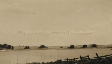 Malmsbury Historical Society
Photograph (Item), B/W Photo Of Malmsbury Reservoir Looking South From West, Malmsbury c1920
... B/W Photo Of Malmsbury Reservoir Looking South From West..." B/W Photo Of Malmsbury Reservoir Looking South From West ...Buildings - "Reservoir, Fence" People - "Swainston, Jessie" -
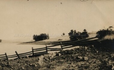 Malmsbury Historical Society
Photograph (Item), B/W Photo Malmsbury Reservoir Looking South From West Side, Malmsbury c1920
... B/W Photo Malmsbury Reservoir Looking South From West Side..." B/W Photo Malmsbury Reservoir Looking South From West Side ...Buildings - "Reservoir, Fence" People - "Swainston, Jessie" -
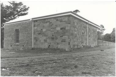 Buninyong & District Historical Society
Photograph - B/W photograph, Clive Brooks, Warden's Office, Butter Factory, (c1859) Cornish St. Buninyong, south and west walls side, 19 July 1993
... . Buninyong, south and west walls side... Depot Couthouse Police B/W photo, west wall of brick Butter ...1850's Gold Rush Police Precinct, later adapted for industrial use, and then used as Council Depot.B/W photo, west wall of brick Butter Factory (c1890), sandstone rear and south walls of Warden's Office (c1859) on right. Cornish St. Buninyong near Yuille St. buninyong, warden's office, butter factory, depot, couthouse, police -
Whitehorse Historical Society Inc.
Article, Full house now at 'vacant' wards, 1992
... and the lack of nominations in the South west ward.... extraordinary elections after the sudden resignation of North West ward... Andrew Rawlings and the lack of nominations in the South west ...Nunawading Council now has a full house for its two extraordinary electionsNunawading Council now has a full house for its two extraordinary elections after the sudden resignation of North West ward councillor Andrew Rawlings and the lack of nominations in the South west ward.Nunawading Council now has a full house for its two extraordinary elections local government, rawlings, andrew, city of nunawading, kliska, adam, hennigan, michael, zimmerman, henry, o'sullivan, kevin -
 Kilmore Historical Society
Photograph, Looking South on Sydney Street from Union Street, 1860
... 25cm x 20cm black and white photograph of South-West Sydney...-33 Copy LaTr. 1860 Trainor's Store etc. looking south.... looking south-west from Union St. 25cm x 20cm black and white ...25cm x 20cm black and white photograph of South-West Sydney Street. The buildings that can be seen include Kilmore Timber Yard, Riche Fitzgerald & Co Builders Ironmoncery, Red Lion Hotel. Pictured are people standing under the awning of the Ironmongers. Picture was taken in 1860. This picture is a copy from LaTrobe.Written on the back: Kilmore Historical Society #4.#5.10/86-33 Copy LaTr. 1860 Trainor's Store etc. looking south-west from Union St.shopfronts, storefronts, retail stores, 19th century -
 Warrnambool and District Historical Society Inc.
Administrative record (Collection) - Warrnambool Hospital Records, Warrnambool Hospital Records
... South West Health Care... South West Health Care which incorporates the Warrnambool Base... South West Health Care which incorporates the Warrnambool Base ...Records handed to the Warrnambool & District Historical Society by Warrnambool Hospital AuthoritiesEnsuring maintenance and preservation of Warrnambool Hospital recordsLedgers and other material kept in A3 Archival boxes and housed on shelves in the W.D.H.S. Archives RoomLedgers and other Historical records of the Warrnambool Hospital including Letter Books, Annual Reports, Cash Books, Admissions, Donors' Registers, Receipts and Expenditure Registers and Committee Minute Bookswarrnambool hospital and benevolent asylum, warrnambool base hospital, south west health carewarrnambool hospital and benevolent asylum, warrnambool base hospital, south west health care -
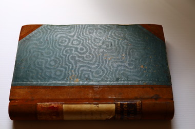
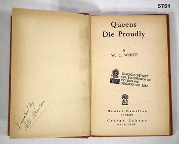 Bendigo Military Museum
Book - BOOK, FLYING FORTRESS WW2, W. L. WHITE, "Queens Die Proudly", 1944
... Book - account of the Flying Fortresses in the South West.... End papers - Illustrated, black and white map South-West... goldfields Book - account of the Flying Fortresses in the South West ...Book - account of the Flying Fortresses in the South West Pacific War WW2,Hard Cover book. Cover - cardboard, orange colour paper with black print on spine. 223 pages - cut, plain, off white paper. End papers - Illustrated, black and white map South-West Pacific. Front end paper and Title page - owner's stamp.Front end paper and Title page - black ink owner's stamp - "BENDIGO DISTRICT/ RSL SUB BRANCH INC/ PO BOX 449/ BENDIGO, VIC, 3552. Opposite Title page - handwritten black ink - "Donated by/ Peter Morrison".books, mikitary history, ww2, flying fortresses -
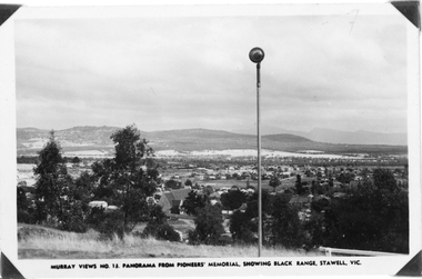 Stawell Historical Society Inc
Photograph, Panorama of Stawell from Pioneer's Memorial, towards the Black Range. Murray Views No.13
... Murray Views No. 13. Panorama over Stawell, looking South...Two similar views of Stawell. One Murray views looing south... of Stawell. One Murray views looing south west (29.5) and the other ...Murray Views No. 13. Panorama over Stawell, looking South West. Spotlight on Pioneer's Memorial (29,5). Black Range in background, grassland on Big Hill at front of Photo. St Patrick's Church visible, Kinsella House. The larger photo 29.5a is a slightly closer view of same scene and shows the "new" school (corner Patrick & Holt Street) opened in 1934.Two similar views of Stawell. One Murray views looing south west (29.5) and the other a larger photo showing school building beside church (29.5a).Murray Views No.13. Panorama from Pioneer's Memorial, showing Black Range, Stawell, Vic. (on 29.5)stawell, panorama -
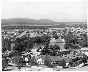 Stawell Historical Society Inc
Photograph, Cato Lake from top of clock tower c 1965
... Photo taken from top of clock tower c 1965 looking South... of the clock tower looking South West. c 1965.... of the clock tower looking South West. c 1965. Cato Lake from top ...Photo taken from top of clock tower c 1965 looking South West. Black Range in background. Stawell West State School is in the far top right just in front of a band of trees. The swimming pool is hidden by pine trees in the center of the lake and identified but a line of flag posts either side of the pool.Aerial black and white view of Cato lake. One photo is original and the other a copy. The photo was taken from the top of the clock tower looking South West. c 1965.stawell, streetscape -
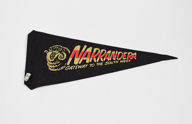 National Wool Museum
Pennant
... NARRANDERA (in pink and white) GATEWAY TO THE SOUTH WEST... and white) GATEWAY TO THE SOUTH WEST (white) GATEWAY TO THE SOUTH ...NARRANDERA (in pink and white) GATEWAY TO THE SOUTH WEST (white) GATEWAY TO THE SOUTH WEST (white) NARRANDERA (pink)narrandera, new south wales -
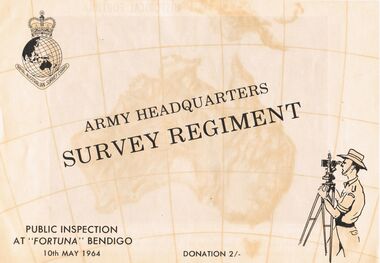 Bendigo Historical Society Inc.
Document - ARMY HEADQUARTERS SURVEY REGIMENT, BENDIGO, 10 May, 1964
... theatres of operation in the South West Pacific Area... Territories and theatres of operation in the South West Pacific Area... Territories and theatres of operation in the South West Pacific Area ...Army Headquarters Survey Regiment, Bendigo. Public Inspection at 'Fortuna', 10 May 1964. Donation 2/-. Includes photos of the Entrance Hall, Music Room and Villa. 3 army photos. In 1942 the mansion was occupied by the Australian Survey Corps and 'Fortuna' became the site of the base map production plant of the Australian Army for the remainder of the war years. During this period approximately sixteen million maps of Australian Territories and theatres of operation in the South West Pacific Area, were produced for use by the Allied Services. This function was continued as a peace time role in the post war years, and in 1951 ''Fortuna'' was purchased by the Commonwealth Government. As the largest unit of the Royal Australian Survey Corps, AHQ Survey Regiment carries out mapping in all parts of the Commonwealth and Territories including Papua and New Guinea. The Regiment is not only capable of doing its own field surveys but is responsible for the drawing and printing of map compilations from Royal Australian Survey Corps units in all States. . . . Includes map of grounds.buildings, residential, fortuna villa, army headquarters survey regiment, bendigo. public inspection at 'fortuna', 1964. photos of the entrance hall, music room and villa. mansion was occupied by australian survey corps and 'fortuna' site of the base map production plant australian army war. sixteen million maps australian territories and theatres of operation in the south west pacific area, were produced for use by the allied services. 1951 ''fortuna'' was purchased by the commonwealth government. royal australian survey corps, ahq survey regiment mapping commonwealth and territories including papua and new guinea. royal australian survey corps units in all states. map of grounds -
 Buninyong & District Historical Society
Photograph - B/W photograph, 1970
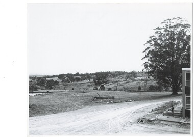
... South West Corner of North Wing... Helen University Trees South West Corner of North Wing Black ...Early photograph taken in 1969 showing first buildings of Mount Helen Campus of Ballarat University built on early estate near Green Hill. Significant tertiary institution established in the historical pastoral area of Green HillBlack and white photo of early buildings of Mount Helen Campus of University of Ballarat South West Corner of North Wingeducation, green hill, mount helen, university, trees -
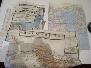 Ballarat RSL Sub-Branch Inc.
Maps - Cloth x 3
... South West Pacific Area; Mindanao; Halmahera... goldfields Maps Ballarat RSL Ballarat South West Pacific Area ...South West Pacific Area; Mindanao; Halmaheramaps, ballarat rsl, ballarat