Showing 1550 items matching " streetscape"
-
 Bendigo Historical Society Inc.
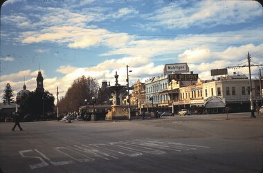
Slide - CASTLEMAINE HISTORICAL SOCIETY COLLECTION, ALEXANDRA FOUNTAIN, 1955
Slide. Alexandra Fountain, Charing Cross, Bendigo. Pall Mall streetscape in background. Dated 28.5.55slide, bendigo, alexandra fountain, castlemaine historical society collection alexandra fountain charring cross bendigo -
 Robin Boyd Foundation
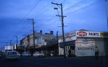
Slide, Robin Boyd, 1969
Colour slide in a mount. Streetscape Victoria St (looking east), corner of Lambert St, Richmond.Made in Australia / 35 / JUL 69M / Encircled 2A (Handwritten)slide, robin boyd -
 Robin Boyd Foundation
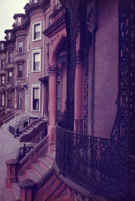
Slide, Robin Boyd, 1956-1957
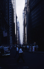
Robin Boyd developed a close friendship with the founder of the Bauhaus in Weimar Germany, Walter Gropius, who had moved to the USA in the 1930s. Through this connection, Boyd was invited to be the Massachusetts Institute of Technology (MIT) Bemis Professor at the School in the North American academic year 1956-7. Robin and Patricia Boyd, with their youngest daughter Suzy, were based in Cambridge, Massachusetts for the year. Boyd gave some lectures at MIT and he was also invited to give lectures at many other universities, allowing him to travel widely within the USA, especially on the East Coast. This gave him the opportunity to meet architects like Frank Lloyd Wright, Eero Saarinen, Paul Rudolph and many others, and visit the offices of Skidmore, Owings and Merrill, and places like Taliesin and the General Motors Technical Center Detroit. On the way home, the Boyds visited London, Berlin, Paris and Le Corbusier’s Ronchamp Chapel in France.Colour slide in a mount. Brownstone streetscape east coast, possibly New York or Boston, USAMade in USA / Patentedmit bemis professorship, mit, robin boyd, slide -
 Eltham District Historical Society Inc
Negative - Photograph, Unidentified residential street, possibly Eltham North, c. Oct. 1989
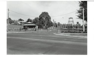
View of rollover kerbing and residential streetscape with plantings on the nature strip. Previous frame was Looking north along Ryans Road at intersection with Kerrie Crescent, Eltham. This was the last frame on the roll of film. There are two slide transparencies shot at the same time Cross Ref: 04174 and 04175Roll of 35mm colour negative film, 1 stripsFuji 100eltham north, houses, residential, streets, streetscape, unidentified, infrastructure -
 Buninyong & District Historical Society
Photograph - Original B/W Photograph, De Soza park, Warrenheip St., Buninyong, with poppet head, rotunda and Chilean Wheel sculpture
De Soza park was developed as a public amenity from the early 1980s. The poppet head and Chilean wheel sculpture are representative of the gold mining origins of the town.The park, located centrally in Buninyong is of social and historic significance.Original B/W photograph of streetscape of De Soza park frontage to Warrenheip St., Buninyong, with poppet head, rotunda and Chilean Wheel sculpture, former post office in background. Large eucalypt tree present behind rotunda, large cypress tree to north of park.buninyong, de soza, park, rotunda, poppet head, sculpture, chilean wheel, post office, warrenheip st, streetscape -
 Canterbury History Group
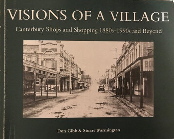
Book, Don Gibb et al, Visions of a Village : Canterbury shops and shopping 1880s-1990s, 2007
Focussing on the growth and activities that took place in the shopping and service centre of Canterbury and Maling Roads in Canterbury from the 1880s to the present, it is partly a guide book to the present buildings of the centre through the streetscapes and brief lives of each of the premises.74 pages; black and white illustrations and photographs, including sketches of streetscapes. Includes bibliographical references and indexnon-fictionFocussing on the growth and activities that took place in the shopping and service centre of Canterbury and Maling Roads in Canterbury from the 1880s to the present, it is partly a guide book to the present buildings of the centre through the streetscapes and brief lives of each of the premises.canterbury road shopping centre, maling road, maling road> shops, shops, retail trade, commercial establishments, streetscapes, gibb> don, warmington> stuart -
 Canterbury History Group
Book, Don Gibb et al, Visions of a Village : Canterbury shops and shopping 1880s-1990s and Beyond, 2016
Focussing on the growth and activities that took place in the shopping and service centre of Canterbury and Maling Roads in Canterbury from the 1880s to the present, it is partly a guide book to the present buildings of the centre through the streetscapes and brief lives of each of the premises.74 pages; black and white illustrations and photographs, including sketches of streetscapes. Includes bibliographical references and indexnon-fictionFocussing on the growth and activities that took place in the shopping and service centre of Canterbury and Maling Roads in Canterbury from the 1880s to the present, it is partly a guide book to the present buildings of the centre through the streetscapes and brief lives of each of the premises.canterbury road shopping centre, maling road, maling road> shops, shops, retail trade, commercial establishments, streetscapes, gibb> don, warmington> stuart -
 Bendigo Historical Society Inc.
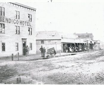
Photograph - BRIDGE STREET: SANDHURST, 1861
Copy of black and white photo: Bridge Street streetscape near site of the present Chinese Museum. Showing Bendigo Hotel at left,. 'Crossingham & Goodman, Saddlers ' ' J. Holdsworth', 'Glass and Chines Warehouse'. 'Batchelder, Photographer, Pall Mall' handcart in foreground. 3 storey weatherboard building with 3 males at door, 2 males and photographers cart in front of fence. Row of single storey buildings with verandahs, some with business signs. 2 storey building at back. Deep gutters with foot bridges over. On back in grey lead '12' Note: Batchelder and his assistant are standing at the hardcart' ( James Lerk 22.9.2000 }Batchelder, Pall Mallplace, streetscape, bridge street -
 Bendigo Historical Society Inc.
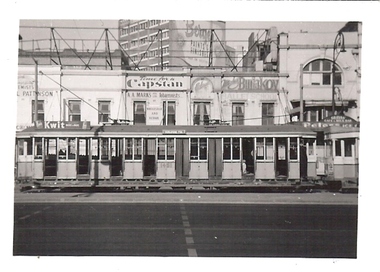
Photograph - BASIL MILLER COLLECTION: TRAM 1451
Black and white photo of tram on streetscape, no 1451. 'LB Manny Collection Photo No 39' stamped on back of photo.person, individual, basil miller -
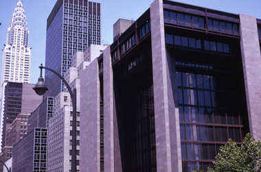 Robin Boyd Foundation
Slide, Robin Boyd, 1969
Robin Boyd travelled to the USA and Britain for several weeks. He attended the opening of the new Australian Chancery in Washington DC, where he had designed an innovative exhibition with cylindrical display cases and sound recordings.Colour slide in a mount. NYC streetscape showing Ford Foundation (S0990) foreground and Chrysler Building (S0522) backgroundMade in Australia / 8 / JUL 69M2slide, robin boyd -
Canterbury History Group
Photograph - Streetscape along Maling road outside No. 88 Maling Road, Jan Pigot, 27/03/1993 12:00:00 AM
Coloured photograph of the streetscape outside No.88 Maling Road showing people sitting outside the Maling Road Patisserie.canterbury, maling road, shops, streetscapes, wunderlite ceilings -
Canterbury History Group
Photograph - Streetscape of the corner of Bryson Street and Maling Road, Jan Pigot, 1994
Coloured photograph of the streetscape of the corner of Bryson Street and Maling Road. This is also the corner of the building named The Block 1907.canterbury, maling road, shops, bryson street, the block, buckley family -
 Bendigo Historical Society Inc.
Photograph - PALL MALL, 1860 approx
Black and white photo. Streetscape, Pall Mall. Shop fronts from left to right include Macords Commercial Hotel, Thomas Rogers & Co., J. Barwick, H. Hoad & Co, Criterion Store, Batchelder Portrait Rooms, Parker & Macord, tobacconist shop, S. Alexander, Theatre Royal ( including Cobb & Co., booking office ) Original in State Library. On Front 'Batchelder/Sandhurst' Buggies and other vehicles at left and along road. Trees with guards planted along Pall Mall. Shows Pall Mall from corner of Bull St., ( Macords Commercial Hotel ) to Threatre Royal at Shamrock Hotel, near Williamson Street.Batchelderplace, streetscape, pall mall -
 Kiewa Valley Historical Society
Photographs – Kiewa Cres Mt Beauty. Circa 1993. Set of 12 colour photographs
Established in 1946, during the construction of the Kiewa Hydro Electric Scheme, the township of Mt Beauty was developed by the State Electricity Commission of Victoria to provide additional accommodation for the thousands of workers during the construction of the country’s second largest hydro-electricity scheme. Although these towns were built as temporary accommodation for the workers and their families, many stayed after the scheme finished. Combined with the influx of European migrants, with their rich cultural backgrounds, all played a major part in shaping the future character of the Mount Beauty, the Kiewa Valley and Falls Creek. The Bright Council, now the Alpine Shire took over the control of the township in 1960. This relatively young town of Mount Beauty, along with the surrounding townships of Falls Creek, Bogong, Tawonga South and Tawonga, are all part of a prospering tourist area with excellent services, accommodation, food and a wide range of recreational activities available for all ages. According to Shire records, the population of Mt Beauty has grown from 1,500 in 1981 to 1,800 in 2016 with a projected increase to 2,000 in 2013The photographs taken around 1993 show a prosperous commercial centre catering for both locals and the needs of visitors. It provides a pictorial history of the changes which have occurred in the retail/commercial district of Mt Beauty over the years. It also demonstrates the attention paid by Alpine Shire towards providing accessible recreational green space around the town centre.Set of 12 colour photographs of Kiewa Cres Mt Beauty. Circa 1993 showing retail services and streetscape of the time. No markingskiewa cres mt beauty, mt beauty -
 Kiewa Valley Historical Society
Photographs – Lakeside Avenue, Mt Beauty. Circa 1993. Set of 7 colour photographs
Established in 1946, during the construction of the Kiewa Hydro Electric Scheme, the township of Mt Beauty was developed by the State Electricity Commission of Victoria to provide additional accommodation for the thousands of workers during the construction of the country’s second largest hydro-electricity scheme. Although these towns were built as temporary accommodation for the workers and their families, many stayed after the scheme finished. Combined with the influx of European migrants, with their rich cultural backgrounds, all played a major part in shaping the future character of the Mount Beauty, the Kiewa Valley and Falls Creek. The Bright Council, now the Alpine Shire took over the control of the township in 1960. This relatively young town of Mount Beauty, along with the surrounding townships of Falls Creek, Bogong, Tawonga South and Tawonga, are all part of a prospering tourist area with excellent services, accommodation, food and a wide range of recreational activities available for all ages. According to Shire records, the population of Mt Beauty has grown from 1,500 in 1981 to 1,800 in 2016 with a projected increase to 2,000 in 2013The photographs taken around 1993 show a prosperous commercial centre catering for both locals and the needs of visitors. It provides a pictorial history of the changes which have occurred in the retail/commercial district of Mt Beauty over the years. It also demonstrates the attention paid by Alpine Shire towards providing accessible recreational green space around the town centre.Set of 7 colour photographs of Lakeside Avenue, Mt Beauty. Circa 1993 showing retail services and streetscape of the time. No markingsmt beauty, lakeside ave mt beauty -
 Kiewa Valley Historical Society
Photographs – Tawonga Cres., Mt Beauty. Circa 1993. Set of 4 colour photographs
Established in 1946, during the construction of the Kiewa Hydro Electric Scheme, the township of Mt Beauty was developed by the State Electricity Commission of Victoria to provide additional accommodation for the thousands of workers during the construction of the country’s second largest hydro-electricity scheme. Although these towns were built as temporary accommodation for the workers and their families, many stayed after the scheme finished. Combined with the influx of European migrants, with their rich cultural backgrounds, all played a major part in shaping the future character of the Mount Beauty, the Kiewa Valley and Falls Creek. The Bright Council, now the Alpine Shire took over the control of the township in 1960. This relatively young town of Mount Beauty, along with the surrounding townships of Falls Creek, Bogong, Tawonga South and Tawonga, are all part of a prospering tourist area with excellent services, accommodation, food and a wide range of recreational activities available for all ages. According to Shire records, the population of Mt Beauty has grown from 1,500 in 1981 to 1,800 in 2016 with a projected increase to 2,000 in 2013The photographs taken around 1993 show a prosperous commercial centre catering for both locals and the needs of visitors. It provides a pictorial history of the changes which have occurred in the retail/commercial district of Mt Beauty over the years. It also demonstrates the attention paid by Alpine Shire towards providing accessible recreational green space around the town centre.Set of 4 colour photographs Tawonga Crescent, Mt Beauty. Circa 1993 showing retail services and streetscape of the time No markingstawonga cres mt beauty -
 Kiewa Valley Historical Society
Photographs – Kiewa Cres Mt Beauty. Circa 1993. Set of 12 colour photographs, circa 1993
Established in 1946, during the construction of the Kiewa Hydro Electric Scheme, the township of Mt Beauty was developed by the State Electricity Commission of Victoria to provide additional accommodation for the thousands of workers during the construction of the country’s second largest hydro-electricity scheme. Although these towns were built as temporary accommodation for the workers and their families, many stayed after the scheme finished. Combined with the influx of European migrants, with their rich cultural backgrounds, all played a major part in shaping the future character of the Mount Beauty, the Kiewa Valley and Falls Creek. The Bright Council, now the Alpine Shire took over the control of the township in 1960. This relatively young town of Mount Beauty, along with the surrounding townships of Falls Creek, Bogong, Tawonga South and Tawonga, are all part of a prospering tourist area with excellent services, accommodation, food and a wide range of recreational activities available for all ages. According to Shire records, the population of Mt Beauty has grown from 1,500 in 1981 to 1,800 in 2016 with a projected increase to 2,000 in 2013The photographs taken around 1993 show a prosperous commercial centre catering for both locals and the needs of visitors. It provides a pictorial history of the changes which have occurred in the retail/commercial district of Mt Beauty over the years. It also demonstrates the attention paid by Alpine Shire towards providing accessible recreational green space around the town centre.Set of 12 colour photographs Kiewa Cres Mt Beauty. Circa 1993 showing retail services and streetscape of the time. No markingskiewa crescent mt beauty; shopping centre; -
Federation University Historical Collection
Document - Report, Andrew Ward, Ballarat Heritage Review, 1998, 1998
City of Ballarat Heritage review including introduction and objectives, study area, summary of recommendations, significant streetscapes, and smaller towns.ballarat heritage study, ballarat, heritage, architecture, streetscapes, landscape importance, mining importance, addington, ascot, bald hills, buninyong, burnside, burrumbeet, coghill's creek, dowling forest, durham lead, glendaruel, learmonth, miners rest, mount blowhard, scotchman's lead, smythes creek, tourello, weatherboard, windermere, andrew ward -
 Surrey Hills Historical Society Collection
Photograph, Trafalgar Street, Surrey Hills
This was taken to record part of the course of the former Surrey Hills Golf Club. The Surrey Hills Golf Club was founded by Mr Hugh W McLeod in 1894. The first president was Mr A W Harston. Mr William Meader was the first honorary secretary and the club champion for several years. Another notable identity was Mr. Harry Culliton, who contributed golf notes to "The Argus" for many years. As pressure for land for development grew, the club was forced to move. It eventually became the Riversdale Golf Club and its history is outlined in the book 'Riversdale Golf Club: a history 1892-1977' by John Arnold.A coloured photograph of a streetscape. A red brick house and fence can be seen on the one corner, street trees line the street.surrey hills, trafalgar street, nelson street, wolseley street, golf, 1997, streetscapes, 1902, mr george meader, first president of golf club, mr h w mcleod, mr a w harston, mr william meader, mr harry culliton, riversdale golf club, mr john arnold -
Clunes Museum
Painting - PAINTINGS, David Williams
Images of; Horse Trough & Wagon Residence 94 Bailey Street Former Presbytery St. Thomas Aquinas Former Clunes Free Library Residence 25 Camp Street Monument 100 years of gold Clunes in Melb Monument Former butcher's shop Fraser Street Residence & shops 41-43 Fraser Street Clunes School of Mines Clunes War Memorial Residence 32 Leslie St Clunes Former suspension bridge Former St Paul's Vicarage 42 Service Street Former Police Office Former Police residence Portable Lock Up Former Dow Residence 9 Hill St Former Hall & Fire Station 2 Hill St St Paul's timber Church hall St Paul's Church Masonic Lodge 23 Service St St Paul's Pulpit Masonic Lodge interior Everhard cordial bottles Scythes in Clunes Museum Ascot Blacksmith shop Former Ascot hotel MIA Hall Ascot The Coghill Monument Former Methodist Church Coghills Creek Clunes Cemetery Chapel Maiden Hill Homestead shearing shed Beckworth Court stables Beckworth Cour shearer's quarters Former School Evansford Glengower Outbuilding Amerst Former Mortuary 46-50 Fraser Street Wood fired heater Beckworth court farm shed Gold mine trolley Servant's bells Maiden Hill cow bail Former South Clunes school 29 George Street 70 Fraser Street Former Post Office "Allowah" Clunes Street Ascot "Homestead" Beackwith Court "The Meat House" Beckwith Court "Shearing Sheds" Beckwith Court Evansford Community Hall 54 watercolours remaining from the 2003 exhibition held at Clunes, all unframed, depicting Clunes and surrounds architecture and streetscapes.BY DAVID WILLIAMSwatercolour, 2003 exhibition -
 Clunes Museum
Painting
RICHARD FORD, CLUNES ARTIST, TEACHEROIL PAINTING IN A WOODEN FRAME BY RICHARD FORD. AN OLDER PERIOD STREETSCAPE OF CLUNES. POSSIBLY VIEWED FROM SCHOOL HILL.richard ford -
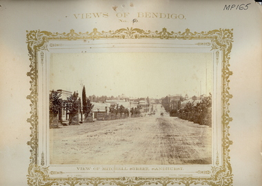 Bendigo Historical Society Inc.
Photograph - VIEWS OF BENDIGO: MITCHELL STREET, SANDHURST, 1875
Sepia tones photograph. Streetscape of Mitchell Street, Sandhurst. Street plantation with protective barricades. Horse drawn vehicle on roadway. Inscriptions: 'Views of Bendigo No. 50'. 'NJ Caire, Photo, Sandhurst', 'Casey & Wenborn" print', 'Forbes and Holmes, Agents', 'Royal Historical Society of Victoria, Bendigo Branch', '1959', '193' in circular stamp on back. Top margin - 'Views of Bendigo, No. 50', Below image - 'View of Mitchell Street, Sandhurst', 'NJ Caire, Photo, Sandhurst', Bottom margin - 'Casey & Wenborn's print, Forbes & Holmes, Agents'. In image ' C H Hoffmeyer', 'Building Materials'. Nicholas CaireN J Caire, Sandhurstplace, streetscape, mitchell street, bendigo -
 Bendigo Historical Society Inc.
Photograph - HARGREAVES STREET, 1920
Black and white/sepia. Streetscape with horse and carts. Elms in winter and bring building (two stories) together with vacant blocks with piles of bricks (Hargreaves St). Inscriptions: on front - 'Perc Pinder, Bendigo', 'MP 131'. On back - 'MP 131'. 'Hargreaves St between Mundy and Chapel St c.1920 Percival Pinder Photographer', 'Percival Pinder Photographer.Perc Pinderplace, streetscape, hargreaves street, bendigo, transport, horse and cart, buildings, cart, sheds -
 Kiewa Valley Historical Society
Photographs – Holland Street North, Mt Beauty. Circa 1993. Set of 18 colour photographs
Established in 1946, during the construction of the Kiewa Hydro Electric Scheme, the township of Mt Beauty was developed by the State Electricity Commission of Victoria to provide additional accommodation for the thousands of workers during the construction of the country’s second largest hydro-electricity scheme. Although these towns were built as temporary accommodation for the workers and their families, many stayed after the scheme finished. Combined with the influx of European migrants, with their rich cultural backgrounds, all played a major part in shaping the future character of the Mount Beauty, the Kiewa Valley and Falls Creek. The Bright Council, now the Alpine Shire took over the control of the township in 1960. This relatively young town of Mount Beauty, along with the surrounding townships of Falls Creek, Bogong, Tawonga South and Tawonga, are all part of a prospering tourist area with excellent services, accommodation, food and a wide range of recreational activities available for all ages. According to Shire records, the population of Mt Beauty has grown from 1,500 in 1981 to 1,800 in 2016 with a projected increase to 2,000 in 2013The photographs taken around 1993 show a prosperous commercial centre catering for both locals and the needs of visitors. It provides a pictorial history of the changes which have occurred in the retail/commercial district of Mt Beauty over the years. It also demonstrates the attention paid by Alpine Shire towards providing accessible recreational green space around the town centre.Set of 18 colour photographs Holland Street North, Mt Beauty. Circa 1993 showing retail services and streetscape of the time. No markingsholland st mt beauty, mt beauty -
 Kiewa Valley Historical Society
Photographs – Holland Street South, Mt Beauty. Circa 1993. Set of 16 colour photographs
Established in 1946, during the construction of the Kiewa Hydro Electric Scheme, the township of Mt Beauty was developed by the State Electricity Commission of Victoria to provide additional accommodation for the thousands of workers during the construction of the country’s second largest hydro-electricity scheme. Although these towns were built as temporary accommodation for the workers and their families, many stayed after the scheme finished. Combined with the influx of European migrants, with their rich cultural backgrounds, all played a major part in shaping the future character of the Mount Beauty, the Kiewa Valley and Falls Creek. The Bright Council, now the Alpine Shire took over the control of the township in 1960. This relatively young town of Mount Beauty, along with the surrounding townships of Falls Creek, Bogong, Tawonga South and Tawonga, are all part of a prospering tourist area with excellent services, accommodation, food and a wide range of recreational activities available for all ages. According to Shire records, the population of Mt Beauty has grown from 1,500 in 1981 to 1,800 in 2016 with a projected increase to 2,000 in 2013The photographs taken around 1993 show a prosperous commercial centre catering for both locals and the needs of visitors. It provides a pictorial history of the changes which have occurred in the retail/commercial district of Mt Beauty over the years. It also demonstrates the attention paid by Alpine Shire towards providing accessible recreational green space around the town centre.Set of 16 colour photographs Holland Street South, Mt Beauty. Circa 1993 showing retail services and streetscape of the time. No markingsholland st mt beauty, mt beauty -
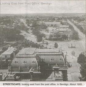 Bendigo Historical Society Inc.
Newspaper - JENNY FOLEY COLLECTION: STREETSCAPE
Bendigo Advertiser "The way we were" from 1999. Streetscape: looking east from the post office, Bendigo. About 1905.newspaper, bendigo advertiser, the way we were -
Clunes Museum
Book, GEOFF ARNOTT, REMEMBERING WEDDERBURN & NEIGHBOURING TOWNS
HISTORICAL RECOLLECTION OF WEDDERBURN AND SOUNDING TOWNSSOFT COVER BOOK, VARIOUSLY STREETSCAPE, RAILWAY STATION AND PUB IMAGES ON FRONT COVER, TOWN IN FOOD IMAGE ON BACK COVERnon-fictionHISTORICAL RECOLLECTION OF WEDDERBURN AND SOUNDING TOWNSwedderburn history, wedderburn townships -
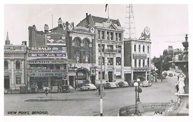 Bendigo Historical Society Inc.
Postcard - VIEW POINT, BENDIGO
black and white photo: View Point, Bendigo. Alexandra Fountain on Rh side, View Street , Armstrong Tyre Service, Australian Mutual Provident Society, Colonial Mutual Life Building, Greyhound Racing buildings in streetscape. Cars parked along kerb. ? Late 1930's early 1940's. On bottom of photo: View Point, Bendigo. No. 14. On back ' Valentine's Post Card, sending you greetings, for address only.Valentine's Post Cardplace, streetscape, view point, view point, alexandra fountain, view street, armstrong tyre service -
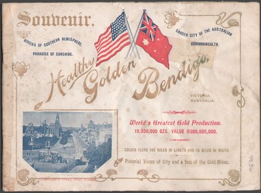 Bendigo Historical Society Inc.
Booklet - Souvenir booklet
BHS CollectionSouvenir booklet detaining many Bendigo buildings, parks and reserves, mining and streetscapes (notably of Charing Cross and Pall Mall). The booklet was presented to visiting American Fleet on 2 Sept.1908. Cover printed in colour to highlight the American flag and Australian Naval flag. Body of the booklet contains one-page photographs of buildings and streetscapes of Bendigo.bendigo buildings, parks and reserves, mining and streetscapes -
 Robin Boyd Foundation
Slide, Robin Boyd, 1956-1957
Robin Boyd developed a close friendship with the founder of the Bauhaus in Weimar Germany, Walter Gropius, who had moved to the USA in the 1930s. Through this connection, Boyd was invited to be the Massachusetts Institute of Technology (MIT) Bemis Professor at the School in the North American academic year 1956-7. Robin and Patricia Boyd, with their youngest daughter Suzy, were based in Cambridge, Massachusetts for the year. Boyd gave some lectures at MIT and he was also invited to give lectures at many other universities, allowing him to travel widely within the USA, especially on the East Coast. This gave him the opportunity to meet architects like Frank Lloyd Wright, Eero Saarinen, Paul Rudolph and many others, and visit the offices of Skidmore, Owings and Merrill, and places like Taliesin and the General Motors Technical Center Detroit. On the way home, the Boyds visited London, Berlin, Paris and Le Corbusier’s Ronchamp Chapel in France.Colour slide in a mount. New York City streetscape: Woolorth Building (1913) in the background, New York, USA. (Architect: Cass Gilbert.)Made in USA / 15 / Wall St Woolworth far down on the right. Emery Roth standard ? 1/2 down rightmit bemis professorship, mit, robin boyd, slide