Showing 4031 items
matching surveys
-
 Bendigo Historical Society Inc.
Map - STRUGNELL COLLECTION: HUSTLER'S LINE OF REEFS, BENDIGO, September 1913
Map, Hustler's Line of Reef, Hustler's Royal Reserve No. 2, Park Shaft, Bendigo, Plate No. 1X (9). Bulletin No 33 Signed H.A.Whitelaw Underground survey Office Bendigo September 1913 Drawing shows mine shaft to over 1099 feet deep and appears to show samples of connecting horizontal shafts with their respective mineral contentsUnderground Survey Office, Bendigo.map, bendigo, hustler's royal reserve no. 2 mine* -
 Ballarat Tramway Museum
Ephemera, Arnall & Jackson, Ballarat tram timetables, 1972
... Surveys ...Green cloth covered cardboard covers, sewn sections field or survey notebook, with end papers, made by Arnall & Jackson of Brunswick - their No. 641. Use by the BTPS - W. Doubleday and Bill Kingsley - for survey notes during the construction of the BTPS depot access track 1972 and 1977 , including pole survey and other notes. Gives levels around the depot. Full scan of document added as a pdf file 5/6/2019.trams, tramways, btps, surveys, depot, access track -
 Bendigo Military Museum
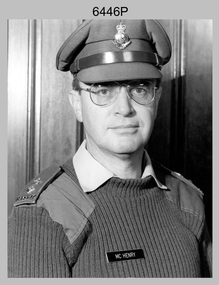
Photograph - LTCOL Rob McHenry – Commanding Officer of the Army Survey Regiment, Fortuna, Bendigo, c1992
This photograph of LTCOL Rob McHenry, the Commanding Officer (CO) of the Army Survey Regiment was taken at Fortuna, Bendigo circa 1992. LTCOL Rob McHenry was the CO from 1992 to 1993.This is a photograph of LTCOL Rob McHenry, CO of the Army Survey Regiment Army Survey Regiment, Bendigo c1992. The photograph was printed on photographic paper is part of the Army Survey Regiment’s Collection. The photograph was scanned at 300 dpi. .1) - Photo, black & white, c1992, CO Army Survey Regiment - LTCOL Rob McHenry. .1P - There are no annotationsroyal australian survey corps, rasvy, army survey regiment, army svy regt, fortuna, asr -
 Ballarat Tramway Museum
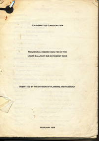
Document - Report, Tramway Museum Society of Victoria (TMSV), "Provisional Demand Analysis of the Urban Ballarat Bus Catchment Area", Feb. 1978
... Surveys ...67 page document on the results of surveys done on Ballarat passenger services in late 1977 and early 1978, dated 2/78. Has survey forms, procedures, questionnaire, results etc. Table of contents, appendices. Printed onto duplicating paper. Single metal paper fastener in top left hand corner.trams, tramways, ballarat, bus services, surveys -
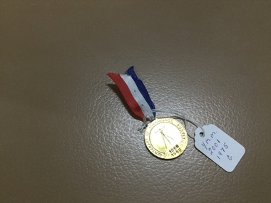 Yarrawonga and Mulwala Pioneer Museum
Medallion
100 year since Yarrawonga originally surveyedCentenary of Yarrawonga Survey 1968 Medallion with red,white and blue ribbon -
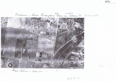 Greensborough Historical Society
Aerial Photograph, Watsonia North 1945, 1945_
Part of 1945 aerial survey, area of Watsonia North, including Grimshaw Street, Sellars Street and Macorna Street, indicating the home of Prudence and Maria Partington in Sellars Street.Photocopy of part 1945 aerial survey"Prudence and Maria Partington's home in Sellars St. Watsonia North"watsonia north, partington family -
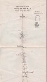 Bendigo Historical Society Inc.
Map - STRUGNELL COLLECTION: HUSTLER'S LINE OF REEF, BENDIGO, September 1913
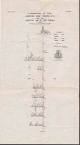
Map, Hustler's Line of Reef, Hustler's Royal Reserve No. 2 Co, Bendigo,Transverse Section, Plate No.V11 (7). Bulletin No 33 Signed H.A.Whitelaw Underground survey Office Bendigo September 1913 Drawing shows mine shaft to over 1640 feet deep and appears to show samples of connecting horizontal shafts with their respective mineral contentsUnderground Survey Office, Bendigo.map, bendigo, hustler's royal reserve no. 2 mine* -
 Bendigo Historical Society Inc.
Map - COMET MINE - LONGITUDINAL SECTION COMET MINE
Longitudinal section of the Comet Mine on the Hustler's Line of Reef Bulletin No 33, Plate No XXVI signed by H. S. Whitelaw, Underground Survey Office Bendigo, September 1913. Map shows datum lines, depths of levels, approximate boundaries and references to other plans. Note - Plates 4, 8, 13, 20, 26 and 31 form a Longitudinal Section from Fortuna Hustler's to Hustler's Consols Mine. This item has not been scanned or photographed.Geological Survey of Victoriamining, parish map, hustler's line of reef, longitudinal section of comet mine bulletin no 33 plate no xxvi, h s whitelaw, underground survey office bendigo september 1913 -
 Bacchus Marsh & District Historical Society
Map, Village allotments, Parish of Myrniong, County of Bourke
Myrniong is a village 9 kilometers west of Bacchus Marsh. Prior to 1863 the area was known as Blow's Flat. This map which was produced in 1903 and according to the catalogue record of this map held at the State Library of Victoria was based on an earlier map created in 1861. The early layout of streets for the village of Myrniong can be seen on this map. The streets shown are, Main Street, Hardy Street, Blow Street, Myrniong Street, Shuter Street, and Blackwood Street. An area marked as a reserve for a school can be seen between Hardy Street and Main Street.A single page paper map. A cadastral parish map of Myrniong in Victoria, showing numbered land allotments. Photo-lithographed at the Department of Lands & Survey, Melbourne, in 1903. Based on an original map created in 1861. The map is pasted into a bound volume containing 76 maps or plans in total. High resolution digital image stored on BMDHS computer network. Surveyed by John Hardy, Surveyor ; photo-lithographed at the Department of Lands & Survey, Melbourne by T.F. McGauran, 24.12.03myrniong parish plan, myrniong parish maps -
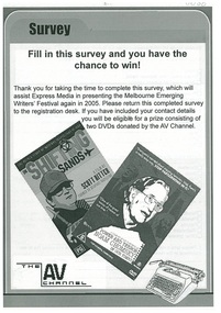 Emerging Writers' Festival
2004 Emerging Writers' Festival Survey
This is the audience survey, developed after the first Emerging Writers' Festival, held in 2004. Surveying and understanding the wants and needs of audiences has always been an important part of programming for the following year at the EWF.A black and white folded survey for audiences of the first Emerging Writers' Festival, held in 2004.2004 emerging writers' festival, richard watts, express media, literary programming, the wheeler centre, emerging writers', literary, festival, melbourne -
Clunes Museum
Book, ROBERT S. BRAIN, BULLETINS OF THE GEOLOGICAL SURVEY OF VICTORIA, 1903
BULLETINS OF THE GEOLOGICAL SURVEY OF VICTORIA, AUSTRALIA.BOOK - "BULLETINS OF THE GEOLOGICAL SURVEY OF VICTORIA.. NO. 6 THE CLUNES GOLDFIELD BY W M. BRADFORD.non-fictionBULLETINS OF THE GEOLOGICAL SURVEY OF VICTORIA, AUSTRALIA.local history, mining, geological survey -
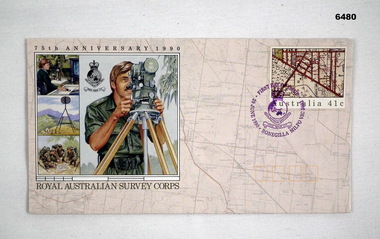 Bendigo Military Museum
Postcard - 75th Anniversary Royal Australian Survey Corps First Day Cover 1990, Australia Post, 29 June 1990
This envelope was specifically produced for the 75th Anniversary of the Royal Australian Survey Corps. This First Day cover envelope was stamped at the Bonegilla Military Post Office on 29 June 1990 in preparation for the Corps birthday on 1 July. The School of Military Survey was located at Bonegilla Victoria adjacent to Lake Hume reservoir. The envelope was designed by Lynette Brown from the Australia Post Graphic Design Studio utilising illustrations produced by Brian Clinton, Melbourne.Royal Australian Survey Corps 75th Anniversary First Day Cover Envelope. The Postal Stamp is stamped with a Survey Corps badge in purple (the Corps Colour) " First day of Issue, Bonegilla Military Post Office 29 June 1990. The 41cent stamp is a map extract. The envelope contains one large and three small graphics of Royal Australian Survey Corps activities and includes a Survey Corps Badge and Logo. The rear of the envelope contains a short history and role of the Royal Australian Survey Corps.royal australian survey corps, rasvy, fortuna, army survey regiment, army svy regt, asr -
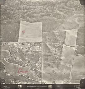 Bendigo Historical Society Inc.
Photograph - MURRAYVILLE SOUTH PROJECT
... surveys ...State Aerial Survey. A set of aerial surveys related to the Murrayville South Project. Run 1. Vic. 2162. 29-2-1968. 53 photos.photograph, aerial, murrayville south project, photos, murrayville south project, state aerial survey, surveys, murrayville, photographs, photography, aerial photography -
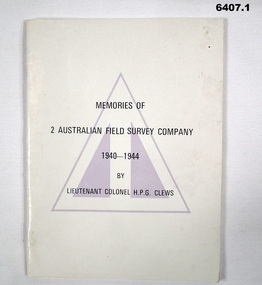 Bendigo Military Museum
Booklet - Memories of 2 Australian Field Survey Company 1940-1944 by LtCol HPG Clews, HPG Clews, 23 Sep 1966
1. This story of 2 Australian Survey Company is not intended to be an official history or even a complete unofficial history, but it is a very warm human document that will be read with interest by all members of the Royal Australian Survey Corps. The history is written by Lieutenant Colonel H.P.G. Clews and the foreward was written by Colonel D. Macdonald Director of Military Survey 23 Sep 1966. Clews is renowned for his work surveying for the construction of the Snowy Mountains Hydro Scheme. A scan of the complete booklet is available on the RASvy website. 3. Photograph of Survey Corps officers in the early days for WWII. Left to right, TA Vance (Director of Survey Corps), TP Keig, OGF Ward and HPG Clews..1 Cream coloured A5 booklet with Australian Survey Corps colour patch, 48 pages black and white photos and diagrams, folded pages and stapled. .2 Synopsis, (Index) containing "The buildup and operation of the Company", "The break-up of the Company" and Appendices. 2 Australian Field Survey Company .3 A group of Australian Survey Corps Officers in the early days of WWII. Left to Right TA Vance (Director), TP Keig, OGF Ward and HPG Clewsroyal australian survey corps, rasvy, fortuna, army survey regiment, army svy regt, asr -
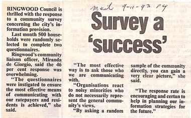 Ringwood and District Historical Society
Newspaper, Scrapbook Clipping, Library Collection, Ringwood, Victoria, `
``Newspaper clipping from The Mail , 29-11-93 P4 Survey a 'success'.Ringwood Council is thrilled with the response to a community survey concerning the city's information provisions.Ringwood's community liaison officer, Miranda de Giorgio, said the 46% response was overwhelming.` -
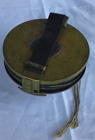 Queenscliffe Maritime Museum
Instrument - Surveying Hydrographic measuring Instrument
Survey tape used by P.J. Larkin, government surveyorInstrument owned and used by a government marine surveyor named P. J. Larkin who worked in Melbourne and Geelong in the 1930s.Survey tape in leather pouch about 100 feet long and housed on brass reel.Purton and Littlejohn's patent Wellington 1663surveying instrument, hydrography, larkin jp -
Greensborough Historical Society
Map, Victoria: Yan Yean, prep. by Australian Section of Imperial General Staff, 1935
Part of 1:63,360 series of survey mapsColour copy from original. Scale: 1: 63,360 (1 inch to 1 mile) 2 copiesRev. 1930 by Australian Survey Corps using RAAF Air Photos. yan yean -
Marysville & District Historical Society
Article (item) - Magazine Article, Coranderrk-A Station Never a Mission, Unknown
A magazine article on the history of Coranderrk based on a historical component of a survey of Coranderrk Station.A magazine article on the history of Coranderrk based on a historical component of a survey of Coranderrk Station.coranderrk, coranderrk station, dr marie hansen fels, healesville and district aboriginal community, john green, healesville, acheron river, mohican, native police corps, merri creek, closer settlement act, badger creek, hops, cattle, royal commission of 1877, board of enquiry 1881, lake tyers -
 Greensborough Historical Society
Map, Poulter Avenue transverse, 1900 c
This is a survey of land acquired from William Haylock Poulter for the construction of Poulter Avenue. Includes area of River Estate and part of Poulter Reserve, Carter Street, Flintoff Street and Plenty River.1 p. photocopy of traverse survey printed in colourSigned by William Haylock Poulterpoutlter avenue greensborough -
 Bendigo Military Museum
Photograph - Army Survey Regiment Personnel – Mahogany Ship Survey, Warrnambool, VIC, 1985
This is a photograph of Army Survey Regiment personnel undertaking surveying measurements during a search for the ‘Mahogany Ship’ Warrnambool, VIC on 3rd September1985. CPL Mark Lander and SGT Don Williams were taking electronic distance measurements using an MRA-301 tellurometer. To measure the distance, personnel at another site operating another MRA-301 tellurometer would have exchanged the signal emission. A ‘Hilga Watts’ light appears in the background and a barometer in the foreground.This is a photograph of Army Survey Regiment personnel undertaking surveying measurements during a search for the ‘Mahogany Ship’ Warrnambool, VIC on 3rd September1985. The photograph was printed on photographic paper and is part of the Army Survey Regiment’s Collection. The photograph was scanned at 300 dpi. L to R: CPL Mark Lander, SGT Don Williams‘R.S. 3/9/1985 CPL Mark Lander, SGT Don Williams PIC BY COURTESY OF THE WARRNAMBOOL STANDARD’ annotated on back of photoroyal australian survey corps, rasvy, army survey regiment, army svy regt, fortuna, asr, surveying -
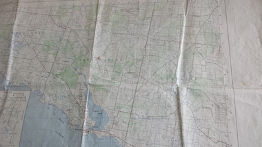 Peterborough History Group
Map - Government map, Government Printer, Port campbell, 1957
Aerial survey map showing roads, vegetation and other landscape features.Significant because it shows the detail of the region in 1957Original 1957 State Aerial Survey Map of Port Campbell region, including Peterboroughpeterborough, aerial survey map, maps, port campell -
Bendigo Historical Society Inc.
Map - GEOLOGICAL MAP OF BENDIGO GOLD FIELD
Two framed laminated maps (a,b) of Bendigo goldfield reef lines, map (b) is a continuation of the reef lines in map (a). On map(a) written in black on top: 'Geological Map, Bendigo Gold Field', Scale of chains, anticlines, synclines, shafts, alluvial and contours marked. Map (b) is continuation of (a). Written on the bottom RH corner of map: 'Prepared in 1923 in the Bendigo Office Mines Department under the direction of H. Herman, Director of Geological Surveys, from surveys by H.S. Whitelaw, Fiield Geologist, assisted by E.S. Usher & J. J. Moore. Re-issued in 1936.'H. Herman, Director of Geological Surveys, from surveys by H.S. Whitelaw, Fiield Geologist, assisted by E.S. Usher & J. J. Moore. Re-issued in 1936.'bendigo, mining, geological map. -
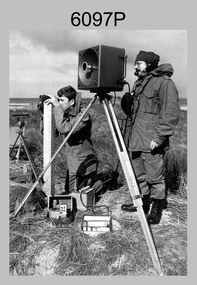
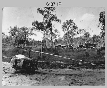 Bendigo Military Museum
Photograph - Bell 47G-2 helicopter used in Royal Australian Survey Corps Field Operations, c1965
This is a set of four photographs of Bell 47G-2 helicopters used in Royal Australian Survey Corps Field Operations. c1965. From 1957, helicopter transport of survey parties revolutionised transport in remote areas. The most common helicopter used by the Royal Australian Survey Corps at this time was the civilian Bell 47G-2 and the Sioux, the Australian Army’s’s equivalent. equivalent. From 1964 an Aerodist MRC2 airborne Electronic Distance Measuring (EDM) system was extensively used for topographic surveys over long distances by trilateration to replace traverse requiring survey station intervisibility. In 1965 the command field survey unit personnel attached to the Army Survey Regiment’s Topographic Squadron were used mainly in support roles such as station clearing, tower operations, station monumenting, Aerodist computations, forward base operations, geodetic observations on the north-south traverse and logistic support for Remote teams. .1P is a photo of a civilian Bell 47G-2 helicopter Registration / Serial VH-UTB owned by Helicopter Utilities from Mascot, NSW c1965. In the background of this photograph is three personnel and vehicles at a field survey camp. The left-hand vehicle is a Willys Jeep with trailer and on the right is probably a Truck, 2 1/2 ton, 6x6, General Service GMC. The Bell 47G-2: VH-UTB was destroyed, and its pilot killed in tragic circumstances during a civilian survey operation on Cape York Peninsula in June 1966. .2P is a photo of a a civilian Bell 47G-2 helicopter Registration / Serial VH-IHB taken in Wyndham, WA. As the letters ‘TAA’ appear on the fuselage, the helicopter was charted from Trans Australian Airways. .3P is a photo of a Bell 47G-2: VH-UTC with survey camp in background. .4P is a photo of a Bell 47G-2 equipped with floats and unidentified personnel loading stores, possibly in Darwin. Acknowledgement: Royal Australian Survey Corps – Aerodist Years 1964-1975 Version 2021.0 Authored by Peter Jensen.This is a set of four photographs of civilian Bell 47G-2 helicopters used in Royal Australian Survey Corps Field Operations. c1965. The photographs were printed on photographic paper and are part of the Army Survey Regiment’s Collection. The photographs were scanned at 300 dpi. .1) - Photo, black & white, c1965, Bell 47G-2 helicopter: VH-UTB with survey camp in background. .2) - Photo, black & white, c1965, Bell 47G-2 helicopter: VH-IHB with survey station in foreground. .3) - Photo, black & white, c1965, Bell 47G-2 helicopter: VH-UTC with survey camp in background. .4) - Photo, black & white, c1965, Bell 47G-2 helicopter: Unidentified personnel loading stores possibly in Darwin..2P – annotated on bottom of photo ‘Wyndham Area – Helicopter drops observing party’ The other photographs are not annotated.royal australian survey corps, rasvy, army survey regiment, army svy regt, fortuna, asr, surveying -
Whitehorse Historical Society Inc.
Map, Blackburn East Primary School
Proposed master plan 1955?Proposed master plan 1955? With Public Works Dept. detail survey 1979. Rolled map.Proposed master plan 1955? blackburn east primary school no. 4800, public works department -
Whitehorse Historical Society Inc.
Map, Parish of Nunawading, 1927
Map of the Parish together with part of the Borough of Box Hill.Map of the Parish together with part of the Borough of Box Hill. Includes names of lease or license holders, sizes of leases and in some areas dates of leases. Roads, railway and stations marked. Original survey by W.J.Busocon, 1915. Manuscript note: 15.2.1927 Verified Dept. Lands and Survey.Map of the Parish together with part of the Borough of Box Hill. maps, parish of nunawading, borough of box hill -
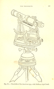 Federation University Historical Collection
Book, Bennett H. Brough, A treatise on Mine-Surveying, 1904
The author, Bennett H. Brough was an associate of theRoyal School of Mines, a member of the COuncil of the Institution of Mining Engineers, a fellow of the geological society and of the Institute of Chemistry, a member of the Mining Institute of Cornwall, and a former instructor of mine-surveying at the Royal School of MinesRed had covered book 372 pages - part of Griffin's Mining Series. Contents include general explanatinos of surveying, an historical sketch, mineral deposits, mining terms, measures of length, measurement distances, the chain, rods, steel bands, measuring wheel, Miner's Dial, Magnetic needle, Fixed needle, German Dial, theodolite, traversing underground. Surface-surveys. plotting the survey, calculation of area, leveling, Telescope, Setting out, Mine-Surveying Problems, Mine Plans, Photographic Surveying, examination Surveying. Illustrations include: Whitelaw's Dial (Fig 22), Theodolite of the American Type with Hoffman tripod head, (fig 37a)mining, surveying, miner's dial, chain, survey, theodolite, scientific instruments -
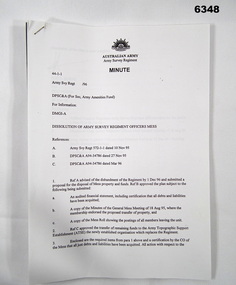 Bendigo Military Museum
Administrative record - Dissolution of Army Survey Regiment Officers Mess, Army Survey Regiment, Bendigo, 1995
The Royal Australian Survey Corps was disbanded in 1996, and as a result the Army Survey Regiment Officers Mess was also disbanded. This minute describes the administrative procedures for the dissolution of the Officers Mess Army survey Regiment Minute 44-1-1, 30 pages A4 paper stapled top left cornerroyal australian survey corps, rasvy, fortuna, army survey regiment, army svy regt, asr -
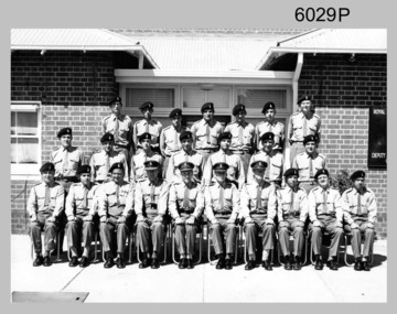 Bendigo Military Museum
Photograph - Central Comd Fd Svy Unit at the Army Survey Regiment, 1966
This photograph of the Central Command Field Survey Unit, Field Survey Detachment was taken in front of the Survey building at Keswick Barracks in Adelaide, South Australia c1966. DR Ridge (later LTCOL) front Centre, SPR RJ Hayden top Right.This is a photograph of the C Comd Fd Svy Unit at the Army Survey Regiment, Bendigo. The photograph was printed on photographic paper and is part of the Army Survey Regiment’s Collection. The photograph was scanned at 300 dpi. .1) Photo, black & white 1966. Front Row to L to R: 5th MAJ Don Ridge. All other personnel are unidentified..1 - “C Comd Fd Svy Unit 1966” annotated on backroyal australian survey corps, rasvy, army survey regiment, army svy regt, fortuna, asr -
Federation University Historical Collection
Plan, Ballarat Common, c 1890
Hand drawn ink plan or field notes for a survey on faintly ruled foolscap paper. Field notes or survey depicting Ballarat Commons, Ballarat Botanical Gardens, Police Paddock and Ballarat Cattle Yards Railways area. 'R.W.' at bottom, Verso 'Ballarat' with various calculations. -
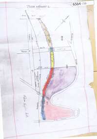
Bendigo Historical Society Inc.
Map - HUSTLERS LINE OF REEFS - LONGITUDINAL SECTION THROUGH THE SADDLE REEFS
Drawing with Longitudinal Section through the Saddle Reefs along portion of Hustler's Line of Reefs, Bendigo. Map shows the depth of the mines, reef numbers and Datum 700 ft above sea level. North and South is also noted on the map. Map signed by H. S, Whitelaw, Underground Survey Office, Bendigo, September 1913. Bulletin No 33, Plate No XXXIV. Bendigo Creek, Ironbark Creek and Long Gully are also noted. Mines are: Fortuna Hustlers, Hustler's Royal Reserve No 2 Main Shaft, Hustler's Royal Reserve No 2 Park Shaft, Royal Hustler's, Imperial Hustler's, Extended Hustler's Freehold, Great Extended Hustler's Tribute (Pups), Old Shaft, Great Extended Hustler's Reef No 2, Great Extended Hustler's Main Shaft, Old Shaft, Hustler's Reef, Hustler's Reef No 1, Comet, K. K., United Hustler's & Redan, Old Shaft and Hustler's Consols. Has Geological Survey of Victoria Crest and underneath is: H. Herman, Director, W. Dickson, Secretary for Mines, The Hon. J Drysdale Brown M L C. Minister of Mines.Geological Survey of Victoria Crestmining, parish map, hustler's reef maps, hustlers line of reefs, bendigo creek, ironbark creek and long gully are also noted. mines are: fortuna hustlers, hustler's royal reserve no 2 main shaft, hustler's royal reserve no 2 park shaft, royal hustler's, imperial hustler's, extended hustler's freehold, great extended hustler's tribute (pups), old shaft, great extended hustler's reef no 2, great extended hustler's main shaft, old shaft, hustler's reef, hustler's reef no 1, comet, k. k., united hustler's & redan, old shaft and hustler's consols.h s whitelaw, underground survey office bendigo september 1913, bulletin no 33 plateno xxxiv, mi