Showing 3924 items matching "1950s"
-
 City of Ballarat Libraries
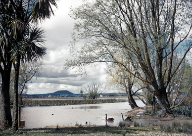
35mm Slide, Lake Wendouree circa 1950s
A view from the "Fairyland" area of the Wendouree Lake showing Mount Warrenheip in the background. Lake Wendouree is often considered the soul of Ballarat according to advertisements from the early 1900's saying "Sydney may have it's Harbour, Melbourne, it's bay but Ballarat has Lake Wendouree." This may have been Mrs.Strange's favorite spot to photograph the Lake, another image in this series captures the same area in a different mood. Mrs Bon Strange and her husband Bert were well known Ballarat residents. When Mrs Strange died some years ago, her extensive slide collection was sorted through and those relevant to Ballarat were gifted to the Ballarat Library.lake wendouree -
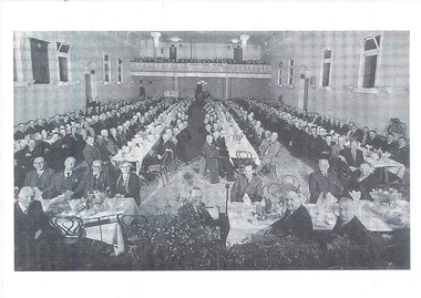 Old Castlemaine Schoolboys Association Inc.
Photograph, Reunion 1950s
-
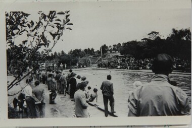 Inverloch Historical Society
000854 - Photograph - Inverloch - 1950s - Pine Lodge - Swimming pool - school sports meeting - from Hazel Swift
-
 Moorabbin Air Museum
Map (Item) - Map of Port Melbourne & Coode Island Rifle Range circa 1950s-60s
-
Moorabbin Air Museum
Booklet (Item) - Aeroplane Magazine Classic Cutaways, 1950s British Classic Cutaways
-
![A Home of My Own: Handy hints and images from domestic life in Australia in the 1940s and 1950s / [collected by] Mary Murray](/media/collectors/550653872162f11fb04854aa/items/5ed03796dcf9cd08346b14b2/item-media/5ed038c8dcf9cd08346b1cfe/item-fit-380x285.jpg) Kew Historical Society Inc
Kew Historical Society IncBook, Mallon Publishing, A Home of My Own: Handy hints and images from domestic life in Australia in the 1940s and 1950s, 2001
vi, 130 p. : ill. ; 27 cm.non-fictionhome economics -- australia., home economics -- australia -- history. -
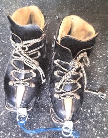 Falls Creek Historical Society
Equipment - Kastinger Boots 1950s
Kastinger Boots Founded by Hermann Kastinger, the company was based in Austria from 1909 to 1981 . After several bankruptcies and changes of ownership, the company Lemipan , based in Pirmasens , Germany , is the current licensee. In 1932, Max Kastinger took over the business from his father. In addition to double-stitched shoes, glued models were also produced for the first time. The decision to use this design laid the foundation for the inexpensive mass production of winter shoes. In 1953 the first successes were also achieved outside of Austria. Sales of the boots took off internationally and were greatly adapted and improved as ski technology also evolved. In 2009, the Kastinger brand celebrated its 100th anniversary. This image is significant because it documents changes in the design of ski boots over time.A pair of black leather lace-up boots with a white leather trim.Kastinger logo on outside of bootsski boots, kastinger boots, ski equipment 1950s -
 Friends of Ballarat Botanical Gardens History Group
Photograph - Digital image TIFF, Maze tower circa 1940-1950s
Tiff file; 1.12MB -
 Wonga Park Community Cottage History Group
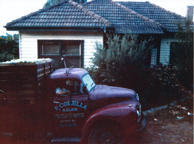
Photograph (Item) - Colour, Wonga Park: Patsy Colella's truck ready for market late 1950s or early 1960s
Frank and Esma Barr had an orchard on the south (uphill) side of Gatters Road and the Colellas had an orchard on the other side of Gatters Road -
 Wodonga & District Historical Society Inc
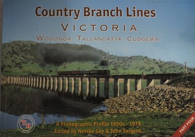
Book - Country Branch Lines Victoria: Wodonga - Tallangatta - Cudgewa: a Photographic Profile 1950s - 1979, Neville Gee and John A. Sargent, 01 Feb 2008
The book covers the branch line that ran eastward from Wodonga past Lake Hume and on to Tallangatta, over the highest point on Victorian Railways at Shelley and terminated at Cudgewa. A photographic profilenon-fictionThe book covers the branch line that ran eastward from Wodonga past Lake Hume and on to Tallangatta, over the highest point on Victorian Railways at Shelley and terminated at Cudgewa. A photographic profilelocomotives -- victoria -- history, cudgewa train, victoria railways, high country trains -
 Charlton Golden Grains Museum Inc
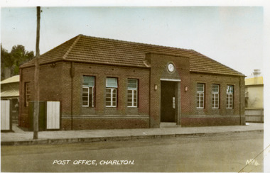
Photograph - Postcard, Charlton Post Office c. 1950s, c.1950
Charlton's third Post Office. The first was built in 1878 in Camp St, the second was an ornate brick building built in 1879 on the present site in High St. The third Post Office was built in 1941 as an upgrade to the earlier building.Postcard showing the brick Post Office building on High Street. Three windows on each side of the central entrance. Clock above the entrance. Signage above entrance Charlton Post Office. Telegraph pole and open gate on LH side of picture. Text at the bottom of the postcard says POST OFFICE, CHARLTON. No. 4.POST OFFICE, CHARLTON No. 4.charlton post office, charlton, business -
 Heidelberg Golf Club
Album - Photograph Album, Heidelberg Golf Club, Heidelberg Golf Club, 1950s-1960s, 1950-1969
Album containing approx 92 black and white photographs of Heidelberg Golf Club and members taken from about 1950-1960s. Album #9 in the photograph collection at HGCBlack hard cover album. Contains approx. 92 black and white photographs of various sizes.heidelberg golf club, photographs -
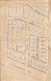
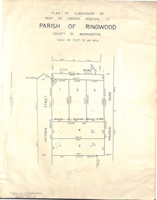 Ringwood and District Historical Society
Document - Folder, Plan of Subdivision - Part of Crown Portion 11, Parish of Ringwood - undated, circa 1950s
Buff coloured survey map of subdivision glued to manilla folder. Five residential blocks bounded by City Road, Victoria Street (later Ireland Street), and Prussia Road (later Regina Street).(Surveyor) R. James Love L.S. M.I.S. (Aust) M.A.I.C. 52 Comer Street Brighton East S6 Phone XB-5928 -
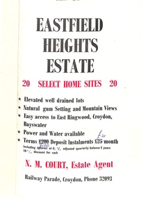 Ringwood and District Historical Society
Flyer, Land Sale Brochure, Eastfield Heights Estate, Croydon. (Undated, circa 1950s)
Bi-fold advertisement for 20 residential allotments with locality map of East Ringwood-Croydon area and map of subdivision bounded by Eastfield Road, and The Pass, Croydon. Agent - N.M. Court, Railway Parade, Croydon, Phone 32093. -
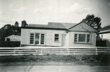 Ringwood and District Historical Society
Photograph, House at 28 Georges Road, Ringwood circa 1950s
Photos donated by Dawn Jones. Her in-laws Cath & Len Jones built the house on land subdivided in 1940s. Cath lived there for 75 years and was 97 in March 2024 (time of donation). Their car a 1934 Chrysler iis outside the house. -
 Ringwood and District Historical Society
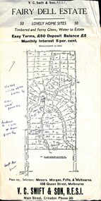
Flyer, Residential Land Sale Sub-division - Fairy Dell Estate, Warranwood, Vic. - circa 1950s
Land sale advertisement for 50 home sites with map of Sub-division showing layout of streets and allotments, summary of local features and services and terms of sale, and copy of sectional map of Crown Allotments 20 & 21B Parish of Warrandyte also showing layout of Sub-division.Subdivision includes Grandview Grove (later Bemboka Road), Merrill Crescent and Kerry Road, Warranwood. Estate Agents - V.C. Swift & Son R.E.S.I., Main Street, Croydon, Phone 20. Solicitors - Morgan, Fyffe & Mulkearns, 108 Queen Street, Melbourne. Handwritten 1970s real estate price notations for some blocks. -
 Ringwood and District Historical Society
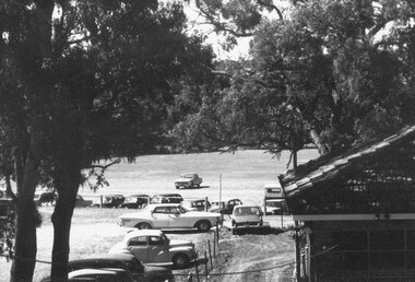
Photograph, Maroondah Highway Central, Ringwood. View overlooking Ringwood Oval from rear of Town Hall, c.1950s
Black and white photographWritten on back of photograph: "Ringwood Oval, c1950's." -
 City of Ballarat Libraries
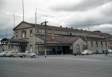
35mm Slide, Alfred Hall, corner Curtis and Grenville Streets, Ballarat circa 1950s
Demolition appears to be under way in this image of the Alfred Hall. It was built in 1867 for the visit of Queen Victoria's son Prince Alfred the Duke of Edinburgh, across the Yarrowee (which formed the municipal boundary) apparently because the municipalities of Ballarat and Ballarat East could not decide who should have the honour! The Alfred Hall held many of the city's events over 89 years, but was symbolically locked up the day the Civic Hall in Mair Street was officially opened, in August 1956. Mrs Bon Strange and her husband Bert were well known Ballarat residents. When Mrs Strange died some years ago, her extensive slide collection was sorted through and those relevant to Ballarat were gifted to the Ballarat Library. alfred hall, curtis street, holden cars, ballarat -
 Ringwood and District Historical Society
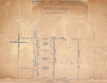
Map, Subdivision Plan of 5 residential allotments on Warrandyte Road and Oban Road, Ringwood, Victoria - (Undated - pre 1950s)
Partial copy of Crown Allotment Map on cardboard backingParish of Warrandyte, County of Evelyn. -
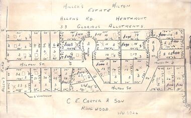 Ringwood and District Historical Society
Pamphlet - Land Sales Brochure, Miller's Estate , Heathmont - circa 1950s
Hand-drawn land subdivision map with 33 allotments of the Miller's Estate on Allens Road, Milton Street, Heath Court and Mont Court, Heathmont. Sold by CE Carter & Son, Ringwood WU6024. (2 copies, one on blue cardboard backing.)LP28038 P/R 1954 -
 Ringwood and District Historical Society
Map, Subdivision Plan - 8 residential allotments south of City Road on Wantirna Road, Ringwood, Victoria - (Undated - circa 1950s)
Hand-drawn map on cardboard backing.Part of Crown Portion 11, Parish of Ringwood, County of Bourke. Some allotments include real estate sales notations. (North arrow incorrectly points east.) -
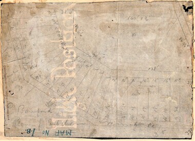 Ringwood and District Historical Society
Map, Planned subdivision on White Horse Road & Warrandyte Road corner, Ringwood, Victoria - (Undated - circa 1950s)
Faded hand-drawn map on lightly transparent paper with cardboard backing. Subdivision plan for Bamford's Timber site, later varied for Safeway supermarket and subsequently part of Eastland shopping precinct by 2020s.P. Bamford -
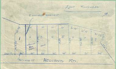 Ringwood and District Historical Society
Map - Subdivision Plans, Residential allotments in Holland Road, Ringwood East, Victoria - (Undated - circa 1950s)
Hand-drawn map on light cardboard backing - 8 numbered allotments on Holland Road (north of Everard Road - not shown). -
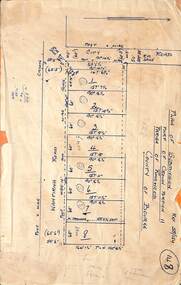
 Ringwood and District Historical Society
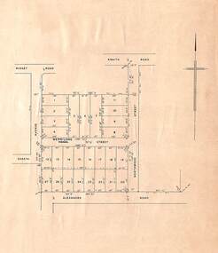
Map, Plan of Subdivision, Shasta Avenue, Merrilong Street, Northwood Street and Alexandra Road, Ringwood East, Victoria - (Undated, circa 1950s)
Printed map on light cardboard backing showing layout and dimensions of 20 residential allotments. -
 Ringwood and District Historical Society
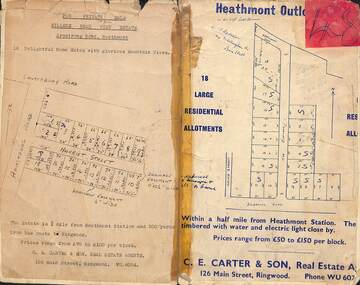
Card - Subdivision Maps, Millers Beau View Estate and Heathmont Outlook Estate Subdivisions, Heathmont, Victoria - (Undated - circa 1950s)
Two maps of seperate parts of Heathmont - Light cardboard backing with handwritten real estate sales notations - 18 home sites on Harriet Street and Armstrong Road and 18 residential allotments on The Outlook and Dickasons Road. -
 Ringwood and District Historical Society
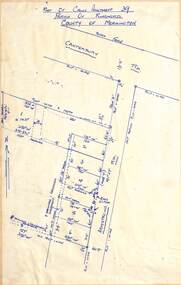
Map - Subdivision Plan, Part of Crown Allotment 39, Parish of Ringwood, County of Mornington, Heathmont, Victoria - (Undated - circa 1950s)
Hand-drawn map on light cardboard backing showing location and size of 6 allotments on western side of Armstrong Road near Canterbury Road, Heathmont. -
 Ringwood and District Historical Society
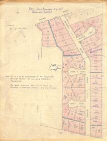
Map - Plan of Subdivision, Part of Crown Allotment 27 & 27B, Parish of Ringwood - (Undated, circa late 1950s)
Copy of land title map in manilla folder showing layout and size of 60 allotments in Railway Avenue, Victoria Street, Smithdene Avenue, Richard Court, Jeanette Court, Bruce Court and Loma Street, Ringwood East, Victoria.Note: Lot 15 is to be transferred to the Ringwood Borough Council for use as a children's playground. Map includes handwritten sales notations for several allotments, e.g. Sold. -
 Ringwood and District Historical Society
Map - Subdivision Plans, Residential allotments in Canterbury Road, Hume Street, Finlayson Street, Gray Street (later Grayview Avenue), and Thomas Street (later Gracedale Avenue), Ringwood East, Victoria - (Undated - circa 1950s)
Hand-drawn map on light cardboard backing. Multiple sets of numbered allotments, with un-numbered lots adjoining a drainage reserve north of Finlayson Street. -
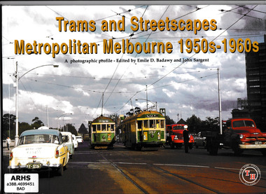 Victorian Railway History Library
Book, Emile D Badawy, Trams and streetscapes: Metropolitan Melbourne 1950s-1960s, 2000
Pictorial History of Melbourne trams in the 1950s and 1960sIll, p.49.non-fictionPictorial History of Melbourne trams in the 1950s and 1960stramways - melbourne - history, tramways - melbourne -
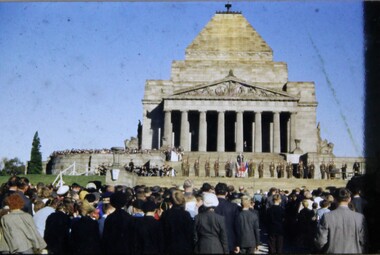 Melbourne Legacy
Slide, ANZAC Commemoration Ceremony for Students, 1950s
Colour slide of a legatee speaking at a Legacy ceremony at the Shrine of Remembrance. One of the annual "Anzac Commemoration Ceremony for Students" events, held just prior to ANZAC Day. The ceremony provides a valuable opportunity for students to gain an appreciation of the Anzac spirit, the significance of the Shrine and the meaning of Anzac Day. The year is unknown but likely to be during the 1950s. Was with many other slides taken in the 1950s and 1960s. The slides have been photographed to make digital images and moved to archive quality sleeves. In many cases the original images were not well focussed and the digital image is the best available.A record of a ceremony for school students at the Shrine run by Legacy for many years.Colour slide of a legatee speaking students at a ceremony at the Shrine in 1950sanzac commemoration for students, wreath laying ceremony