Showing 1579 items
matching a. clarke
-
 Kiewa Valley Historical Society
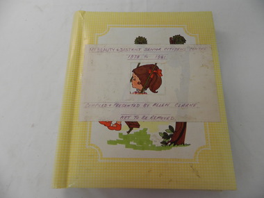
Photo Albums x 2 - Mt. Beauty Senior Citizens Centre, Mt Beauty & District Senior Citizens Centre 1978 - 1981 and 1982 to 1985. Compiled & Presented by Allen Clarke
These albums were put together by Allen Clarke, who worked for the State Electricity Commission of Victoria for over 40 years. He was also a member of the Senior Citizens Club. He collected theses press cuttings, put them in these albums and donated them to the Mt Beauty Senior's Club.1. Yellow cardboard photo album with colorful girl on swing in centre of front cover, overlayed with white paper label with purple printed title. Bound with metal spirax binding. The album contains press cuttings pertaining to the Mt Beauty & District Senior Citizen's Centre between 1978 and 1981. 2.Bluish with whitish coloured mountains (Alpine Scene) cardboard photo album with metal 'Photo Album' plaque stuck on the bottom right hand side. The album contains pres cuttings pertaining to the Mt Beauty & District Senior Citizen's Centre between 1982 and 1985.1. Mt Beauty & District Senior Citizens Centre / 1978 to 1981 on top of label. Compiled & Presented byu Allen Clarke / Not to be Removed on bottome of label 2. Nilsenior citizens; mount beauty; -
 Mt Dandenong & District Historical Society Inc.
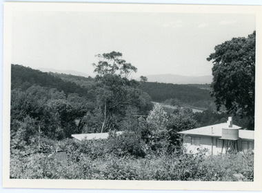
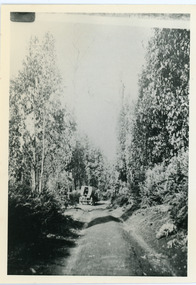
Photograph, View From Ernest Road To Site Of "Kia-Ora"
John Lundy-Clarke grew up in the Kalorama/Mt Dandenong area and later in life (1972-74) began to write a comprehensive history of the area working from an original settlement map in an effort to cover all areas. The photograph taken c1973 from Ernest Road looks over the site of the Kia-Ora guesthouse which is marked by the oalm tree that can be seen at the front of the flat roof close to the gum tree trunk. Situated on Barber’s Road, ‘Kia-Ora’ was built in 1912 by George Barber. It was later leased by a Mrs Pemberthy. “Kia-Ora’ was one of four places connected when the telephone was brought into the district in 1912. The other places were ‘Mountjoy’, ‘Cherry Farm’ and ‘Callum House’. ‘Kia-Ora’ was burnt down in 1924.Black and white photograph showing a house with water tank in right foreground and another flat roof centre foreground. There is a handwritten description by John Lundy-Clarke on the reverse.View 1973 from corner of Ernest Rd and Outlook Drive Lot 24 Village Settlement looking over the site of “Kia Ora” to the pioneers clearings. The palm tree seen above the flat roof (Rex) on left, is on the exact site of “Kia Ora”. Photo JLCernest road, john lundy-clarke, kia=ors, guest house, guesthouse -
 Bacchus Marsh & District Historical Society
Map, Plan of the property of Messers Atkins and Clarke to be sold at the Mansion, Bacchus Marsh 19th April 1856. Copy 1
This plan of land allotments for sale indicates the property once owned by the Bacchus family in and around the township area of Bacchus Marsh. The Bacchus family sold their property in Bacchus Marsh to John Atkins and Robert Nalder Clarke in March 1851. Atkins and Clarke kept the property for a number of years until April 1856 when these allotments were put up for sale.This plan is almost identical to another copy held by the Bacchus Marsh and District Historical Society, VC Record 452, BMDHS collection). This plan, VC Record 707 Copy 1, contains a little more detail overall than VC Record 452 Copy 2, such as who did the survey work for the plan (R.C. Bagot) and who the selling agents were, (W.M. Tennent), and on the right side of the plan near the Lerderderg River is indicated the general area for a second parcel of land from this sale which is to be sold. There is also a compass illustration indicating north and south compass points.This is a very early land sales plan for the township of Bacchus Marsh and it therefore provides some clues as to how the early urban development of the township took place. Upon seeing the map in 1911 Bacchus Marsh Express newspaper editor Christopher Crisp wrote "The sale appears to have created the present township, which had a nucleus in earlier times further east", Express, 30 September, 1911, page 3.A single page paper plan showing allotments of land for sale. The subdivided land shown was owned by John Atkins and Robert Nalder Clarke, but previously owned by the Bacchus Family and was in and around their Manor House (Mansion) property in Bacchus Marsh.There are 5 portions of land further divided into numerous small portions. The land for sale is bounded by the present day streets of Main Street, Young Street, McFarland Street, Morton Streets, Crook Street, and part of the eastern section extends to the Lerderderg River. Scale: 8 chains to 1 inch The plan is pasted into a bound volume containing 76 maps or plans in total. BMDHS Loc: AR/B12/S4 Bacchus Marsh Township and Nearby Districts Maps Volume In-house Digital copies: BMDHS, Computer Network: Maps\Bacchus Marsh Township and Nearby Districts Maps VolumeHeading: Plan of the first portion of land. The property of Messers Atkins and Clarke situate at Bacchus Marsh. To be sold by W.M. Tennent & Co. at the Mansion on the Ground on Saturday the 19th April 1856. Below heading: Jas Ferguson, Lithographer On upper right side: Subdivided by R.C. Bagot London and Liverpool Chambers, Melbourne. 'Thos Taubman'. Post Office Stamp: BACCHUS MARSH VICTORIA MY 6, 63bacchus marsh victoria maps, bacchus family, land sales, manor house bacchus marsh -
 Bendigo Historical Society Inc.
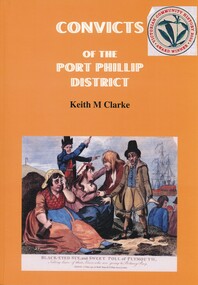
Book - CONVICTS OF THE PORT PHILLIP DISTRICT, 1999
Convicts of the Port Phillip district is a substantial addition to the books about convicts in Australia. The first part is a detailed account of convict settlement in Australia, the second part detailed information about each individual convict.Keith M Clarkeaustralia, history, convicts, australian history, victorian history, family history. -
 Melbourne Tram Museum
Document - Biography, Noelle Jones, "Dr A K Sewell: Tram Photographer", May. 2021
... Dr A K Sewell, Mr A Clarke, Noelle Jones ...Biography - 7 A4 page - titled "Dr A K Sewell: Tram Photographer" giving details of the person who took a number of photos of cable trams in Melbourne during 1938 and 1939 and his medical career - a significant one as a pathologist. Notes his association with Mr A. Clarke while in Melbourne. Prepared by Noelle Jones of the Museum. Has a list of acknowledgements and references.trams, tramways, biography, cable trams, collingwood, nicholson st, carlton -
 Mt Dandenong & District Historical Society Inc.
Photograph, Edward John Price 1973
John Lundy-Clarke grew up in the Kalorama/Mt Dandenong area and later in life (1972-74) began to write a comprehensive history of the district working from an original settlement map in an effort to cover all areas. Edward John Price (Ted)(1899-1974) was the third child of Edward Joseph and Annie Price. He lived a very industrious life in the area. When the new CRB road cut through the family land Edward John established a Corn and Produce store on a level area adjoining the new road . Along with his brother Charlie, Ted took up road contracting and formed Grange Road in 1923. They also took up contracts to metal the CRB road between The Gap and Olinda. Edward John married Myra Wilson in 1930. They lived in the first brick home built in the district. They had two sons, Edward Joseph 2nd and Alan.Black and white photograph showing an old man dressed in a jacket holding the reins of a horse. Reverse of photograph has handwritten description by John Lundy-Clarke.Edward John Price 1973. Son of Edward Joseph & Annie Ada nee Ross. Born 1899 died 1974. Farmer, Carrier, Sawmiller, Contractor, Quarry Owner, Shop Proprietor (Kew Junction 1935). Father of Alan & Edward J.edward john price, myra wilson, edward joseph price, annie price, alan price, charles price, grange road, crb road -
 Mt Dandenong & District Historical Society Inc.
Photograph, Farringdon Road
Mt Dandenong Road (CRB Road, New Road, Main Road) was begun in the early 1920s and completed c1926. This would be a very early photograph in the history of the road and shows a Jeeves coach travelling along the new road at the base of Farringdon Road in Kalorama. Ellis Jeeves established the coach sevice between Kalorama and Croydon in 1904. It originally travelled down the Old Coach Road. John Lundy-Clarke grew up in the Kalorama/Mt Dandenong area and later in life (1972-74) began to write a comprehensive history of the area working from an original settlement map in an effort to cover all areas.Black and white photograph looking down an unmade road showing a coach travelling along another unmade road at the bottom. Roads are tree lined. handwritten inscription on reverse by John Lundy-Clarke.1920 Farringdon Road, looking at Jeeves Coach on Mt Dandenong Road.mt dandenong road, crb road, farringdon road, jeeves, ellis jeeves, coach, mt dandenong tourist road, kalorama -
 Ringwood and District Historical Society
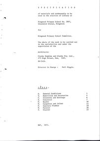
Document, Ringwood State School - Specification of materials and workmanship for erection of Library- May 1973
Typed Specification document submitted to Ringwood Primary School committee. Architects- Clarke Hopkins and Clarke Pty Ltd. Director in Charge- Neil Biggin. -
Eltham District Historical Society Inc
Folder, Robert Clarke, 1860s
Folder of information on Robert Clarke, Queenstown, 1860srobert clarke -
Eltham District Historical Society Inc
Folder, William Clarke, 1850s
Folder of information on William Clarke, Eltham 1850swilliam clarke -
 Clunes Museum
Photograph
FRANCIS AND JANE CLARK (NEE RANKIN). FRANCIS BORN IN NAIRN, SCOTLAND. HE ARRIVED IN CLUNES 1855, AGED 15 YEARS. DIED IN CLUNES APRIL 1921. JANE DIED IN MAY 1921.PHOTOGRAPH OF FRANCIS AND JANE CLARKE (NEE RANKIN)local history, photography, photographs, clark family -
 Ballarat Heritage Services
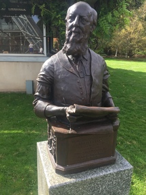
Photograph - Photograph - Colour, Robert Clark Statue, 2016, 27/03/2016
Robert Clark was the editor of the Ballarat Courier newspaper.Statue of Robert Clarke in the Ballarat Botanical Gardens.robert clark, statue, ballarat botanical gardens -
 Ringwood and District Historical Society
Photographs, 1979-80 MMBW pipe line project at Hubbard Reserve, North Ringwood � Boring hole in lot 7
Part of a 43-photo record of the MMBW�s engineering feat in drilling a 12 inch pipe line up to 40 feet deep through rock hardened by volcanic action associated with geological fault that occurs along the line. The work took place from October 1979 to May 1980 on the southern boundary of Hubbard Reserve, North Ringwood. The collection was presented to the Ringwood Historical Research Group by J Clarke on 9th June 1980.E561 N4 Feb 1980 A43 The boring hole, 39' deep, at lot 7 (Clarke's, 39 Burlock Ave) with the generator used to supply light. -
 Ringwood and District Historical Society
Photographs, 1979-80 MMBW pipe line project at Hubbard Reserve, North Ringwood � The work on sewer line from 29-39 Burlock Avenue
Part of a 43-photo record of the MMBW�s engineering feat in drilling a 12 inch pipe line up to 40 feet deep through rock hardened by volcanic action associated with geological fault that occurs along the line. The work took place from October 1979 to May 1980 on the southern boundary of Hubbard Reserve, North Ringwood. The collection was presented to the Ringwood Historical Research Group by J Clarke on 9th June 1980.E561 N11 3 March 1980 A43 The work on sewer line from 29-39 Burlock Avenue. Lundy-Clarke's place on sky-line. -
 Mt Dandenong & District Historical Society Inc.
Photograph, Jasper Road Near Erith Lane 1920, 1920
View of Jasper Road, near Erith Lane taken in 1920. The road is tree lined with two significant gum trees in the foreground. This photograph has a detailed inscription on the back handwritten by John Lundy-Clarke in 1974.Jasper Road near Erith Lane 1920. This road has only a narrow right of way. It was put in as a road to serve “Cherry Farm”, connecting it to the Coach Road at the Elbow in 1904. It joins a wide surveyed road running from Inverness Road to the Coach Road at the Elbow and could possibly have been surveyed by Thomas Hand at the same time as Inverness Road. The name Jasper now applies to full length between Erith Lane and Coach Road. McGivern Bros widened it in 1937 and J L Clarke removed and stored much of the rock quarried in the widening. This was later sold to Dick Moorby who sold it to the builders of St Michaels Church in Falls Road. Comment by John Lundy-Clarke 10.5.1974 jasper road, erith lane, john lundy-clarke -
 Mt Dandenong & District Historical Society Inc.
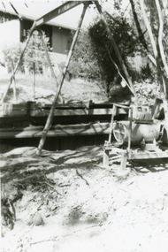
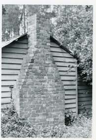
Photograph, Rowse Brothers Worman's Cottage, 1972
1972 photograph of the Rowse Brothers workman's cottage built on the bank of the Olinda Creek in 1938.This photograph has a detailed inscription on the back handwritten by John Lundy-Clarke in 1974.Rowse Bros Workman’s Cottage built in 1938 on bank of the Olinda Creek at the 800’ contour on Crown Allotment 925B of materials and bricks taken on demolishing in the same year the house built in 1897 for J.W. Richardson before his marriage to Jeanie Green and their family’s home till 1912 when they went to Queensland. Sold to Rowses in 1913 was Rowse family home till the thirties then workman’s cottage. Chimney built by J. Lundy-Clarke. Picture Dec 1972 by JLC.rowse, workman's cottage, richardson, olinda creek, kalorama, chimney -
 Mt Dandenong & District Historical Society Inc.
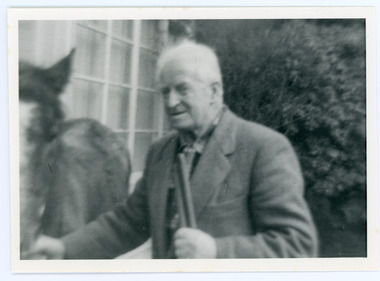
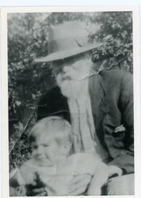
Photograph, Edward Joseph Price and Grandson
John Lundy-Clarke grew up in the Kalorama/Mt Dandenong area and later in life (1972-74) began to write a comprehensive history of the district working from an original settlement map in an effort to cover all areas. Edward Joseph Price took out Lot 1, Section 1 of the Village Settlement and became the first settler, moving his family up into a slab hut on his selection in 1896. Edward Joseph had two sons (Charles Joseph and Edward John) and a daughter (Kathleen Nathalie Caroline). Edward Joseph Price is holding his grandson Teddie, son of Edward John Price. Photo taken 1936.Black and white photograph in close up showing an old man with a white beard wearing a brimmed hat holding a male toddler under the arms. Reverse of photograph has handwritten description by John Lundy-Clarke.Edward Joseph Price and his grandson Teddie son of Edward John. E. Joseph was the first settler in the Village Settlement choosing LOT 1, part of which is still family property (1974). He worked for the surveyors who were marking out the blocks, and disregarded their advice as to which had the best soil, and so doing he obtained the best commercially. He died in 1943 leaving two sons & daughter. Edward John born 1899 died 1974. Charles born 1892 died 1958. Kathleen born 1895 died 1954. Wife Annie nee Ross died 1932.edward joseph price, edward john price, teddie price -
 Montmorency–Eltham RSL Sub Branch
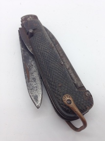
Knife, Clasp, with Marlin Spike and Tin Opener, WW1 era to late 1930s
Knife, Clasp, with Marline Spike and Tin Opener, manufactured in England to the Standard Pattern 6353/1905, as modified in 1913 with specific dimensions to the tin opener. This pattern was used by British forces, and was one of the patterns issued to members of the Australian Infantry Force during WW1. This pattern was used up until the late 1930s, where it was superseded by other patterns.Knife, Clasp, with Marlin Spike and Tin Opener, manufactured to the standard British pattern 6353/1905, as modified in 1913 with changed dimensions for the tin opener. The hilt of the knife has two chequered pattern sides secured by five metal rivets. The underside of the hilt has two recesses to allow storage of the blade and the tin opener. A tapered steel Marline spike is mounted on the other side of the hilt, pivoting at the opposite end to the blade and tin opener. A copper wire shackle is also secured at this end of the hilt that was used to attach the knife to a lanyard or belt clip. A fingernail indentation is located near the top of one side of the blade. The tin opener has bevelled edges tapered to a point on one side, with a steel post mounted in the middle of the other side.J. CLARKE & SON SHEFFIELDknife, clasp, ww1, steel, marline spike, australian infantry force, milirary -
 Bendigo Historical Society Inc.
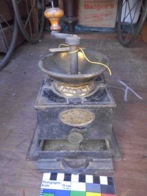
Machine - CAST IRON COFFEE GRINDER
Black Cast Iron Coffee Grinder With Circular Copper Bowl on top and a curved metal handle which is attached to a central grinding mechanism. Main body shape almost square tapers slightly closer to the top. Coffee grinder has a large pullout tray contained in the bottom of the mill. 140 cm High x 40 cm Wide Previous Catalogue Number 103 Inscription T & C Clark & Co Manufacturer Additional Inscription contained in an elliptical brass plaque Paris Silver Medal 1878 Awarded T. & C. Clark & Co. Plaque Also contains images of a replica of the Jules-Clement Chaplain Art Nouveau Designed Silver Medal Exhibition Prize, Consisting of a laureate bust of Marianne Facing Left surrounded by the words Republique Francaise. Beside It An Image of Victory Hovering Above The Exhibition Wearing A Laurel Wreath Blowing A Bugle Announcing Manufacturing Success & Excellence & Below Him Cupin (Child Genius) Holding A Banner With T & C Clark & Co. Around The Outside Edge Exposition Paris Universelle Internationale De 1878.T & C Clarke Manufacturerdomestic equipment, food consumption, coffee grinder -
 Charlton Golden Grains Museum Inc
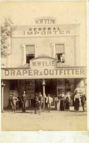
Photograph, Clarke Bros Photographers, W. Wylie shop, c.1890
W. Wylie's store, west end of High St, Charlton. built by Peter Johnson c. 1872, managed by Mr. Gatwood c.1880s, then bought by William Wylie. Group of people standing outside on footpath, young man on a bicycle, 2 children and a man in upstairs windowMounted unframed photograph. W. Wylie's store, west end of High St, Charlton. Group of nine people standing outside on footpath, includes three women, a young man on a bicycle being held by another young man, 2 children and a man in upstairs windowClarke Bros Photographers Windsorw. wylie, general importer, draper & outfitter, johnson's bridge store, high street, charlton -
 Bendigo Historical Society Inc.
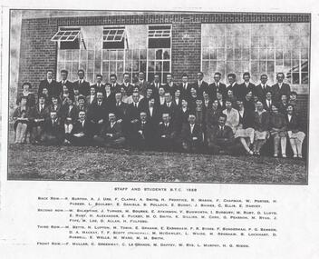
Photograph - LA TROBE UNIVERSITY BENDIGO COLLECTION: BENDIGO TEACHERS' COLLEGE STAFF AND STUDENTS 1928
A very dark black and white copy of a photo of staff and students at Bendigo Teachers College in 1928. The men are all in suits with collar and tie and the women are in skirts or dresses with stockings and formal shoes. Back row - R. Burton, A.J. Ure, F. Clarke, A .Smith, H. Prentice, R. Mason, F. Chapman, W. Porter, H. Parker, L. Soulsby, E. Daniels, S. Pollock, E. Bunny, J. Baines, C. Ellis, E. Harvey. Second row - W. Ballantine, J. Turner, M. Bourke, E. Atkinson, V. Bunworth, I. Burbury, M. Ruby, D. Lloyd, E. Ruby, H. Alexander, E. Puckey, M. O. Smith, K. Gillies, M. Cork, G. Pearson, M. Ryan, J. Fyfe, M. Lee, D. Allan, H. Fulford. Third row - M. Betts, N. Lupton, M. Tobin, E. Graham, E. Earnshaw, F.R. Sides, F. Sunderman, P.G. Samson, D.A. Mackay, T.F. Scott (Principal), M. McGawley, L. Waide, M. Renshaw, B. Lockhart, D. Russell, E. Wells, M. Ward, M.M. Smith. Front row - F. Muller, C. Greenway, C. Le Grande, M. Daffey, W. Rye, L. Murphy, H.G. Nixon. See 3320.100bendigo, education, bendigo teachers' college, la trobe university collection, collection, bendigo, education, tertiary education, teacher training, photo, photos, photograph, photographs, photography, bendigo teachers' college, teacher training, miss j.c. burnett, mr. geoff. pryor, teaching, r. burton, a.j. ure, f. clarke, a. smith, h. prentice, r. mason, f. chapman, w. porter, h. parker, l. soulsby, e. daniels, s. pollock, e. bunny, j. baines, c. ellis, e. harvey, w. balentine, j. turner, m. bourke, e. atkinson, v. bunworth, i. burbury, m. ruby, d, lloyd, e. ruby, h. alexander, e. puckey, m.o. smith, k. gillies, m. cork, g. pearson, m. ryan, j. fyfe, m. lee, d. allan, h. fulford, m. betts, n, lupton, m. tobin, e, graham, e. earnshaw, f.r. sydes, f. sunderman, p.g. samson, d.a. mackay, t.f. scott, m. mcgawley, l. waide, m. renshaw, b. lockhart, d. russell, e. wells, m. ward, m.m. smith, f. muller, c. greenway, c. le grande, m. daffey, w, rye, l. murphy, h.g. nixon -
 Mt Dandenong & District Historical Society Inc.
Photograph, Walker's LOT 2
Harry Walker's property would have been run by his son William in 1922. When the CRB Road cut through the property William planted plum trees on the opposite side. These are visible in this photo. An extensive raspberry crop is in the foreground. The building over the road on the left hand side is the corn and produce store built by Edward John Price (son of Edward Joseph Price) to capitalise on the CRB Road cutting through the Price farm. John Lundy-Clarke grew up in the Kalorama/Mt Dandenong area and later in life (1972-74) began to write a comprehensive history of the area working from an original settlement map in an effort to cover all areas.Small black and white postcard showing a crop in foreground with a house to the right. A road passes through the centre with a house on the left on the opposite side of the road. A view to the ranges in the distance. A handwritten description on reverse by John Lundy-Clarke.View at Kalorama. View over LOT 2 (Walkers) 1922.harry walker, william walker, crb road, raspberry, edward john price, edward joseph price, produce store, store -
Ringwood and District Historical Society
Piece of Rock, Collected by J. Lundy-Clarke, Lump of Black Rock - Sample of Metamorphic Rock from Hubbard Park, Ringwood 1979, Found 1979
Sample of metamorphic rock encountered by M.M.B.W. gang of tunnellers boring for a sewer drain through a geological fault-dyke along the southern boundary of Hubbard Park. The hole for 900 feet of 12.5 inch pipe took 6 months to bore from Oct-1979 to May-1980.Lump of black rock. +Additional Keywords: Lundy-Clarke, J. -
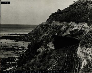 Lorne Historical Society
Photograph, The Cutting near Clarke's at Eastern View
Photograph of the cutting, fence and road near Clarke's at Eastern Viewg.o.r eastern view: cutting near clarke's: fencing: -
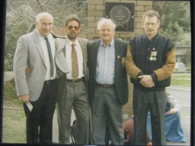 Running Rabbits Military Museum operated by the Upwey Belgrave RSL Sub Branch
Photo
Peter Clarke, Peter Sampson, Barry Piper & Graham Donaldpicture, c2000, general -
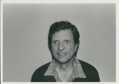 Uniting Church Archives - Synod of Victoria
Photograph, William Clark - theological hall graduate 1984, 1985
"William (Bill) Clark was engineering manager with Fruehauf tractors, and now starts life as a minister at Kaniva. He'd been in transport engineering for almost 30 years before studying for ordination. The children, both grown up, one married, will remain in Melbourne. Bill told me he enjoys working with people and looks forward to the opportunity to share with lay people who know their community, in communicating toward and with the whole community the love and concern of the gospel. Margaret, his wife, enjoys gardening, crocheting, reading and walking. Bill says his other interests are practical work, including welding." 2017 - retired minister.The two photos show head and shoulders of a middle-aged Clarke.C&N identification.clarke, william, margaret clarke, uniting church minister -
 Mt Dandenong & District Historical Society Inc.
Photograph, View From Doughty's Road 1913
Mt Calvin, the homestead of Jeanie and Willie Richardson can be clearly seen in the clearing above the men in the picture. The white roof of the Barber homestead is on the right of the picture. A landslide in 1934 destroyed the tree ferned area. John Lundy-Clarke grew up in the Kalorama/Mt Dandenong area and later in life (1972-74) began to write a comprehensive history of the area working from an original settlement map in an effort to cover all areas.Black and white photograph that is a copy of a Rose series postcard titled 'The Picturesque Road to Mt. Dandenong. Vic.' It shows two men (probably Rose Series employees), one sitting and one standing at the edge of an unmade road. Large tree ferns line the roadside. Handwritten inscription on reverse by John Lundy-Clarke1913 View east from Doughty’s Road showing Jeannie Richardson’s home through the gap in the trees. A little to the right of and below centre of picture can be seen George Barber’s home with Barbers Road turning around the wagon shed that was a little up the hill from the house. The tree ferns in the picture were destroyed in the landslide of 1934. In the distance at the right can be seen F.M. Childs Homestead complex with the Richardson paddocks beyond it.mt calvin, jeanie richardson, willie richardson, george barber, landslide, tree fern -
 Linton and District Historical Society Inc
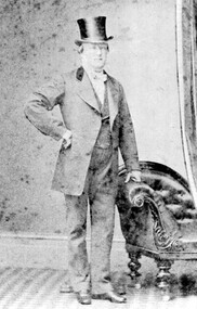
Photograph, Mr. John Clarke
Copy of original photograph. Photograph shows a gentleman wearing suit and top hat, standing with left hand leaning on arm of a chair, right arm crooked at waist height."Mr John Clarke of Piggoreet Station".mr john clarke, piggoreet station -
 Kew Historical Society Inc
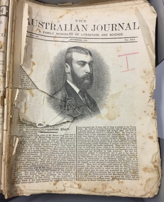
Journal, The Australian Journal : a family newspaper of literature and science, 1881-83, 1881-83
The Australian Journal (1865-1962), was founded as a weekly but changed to a monthly in 1869. It included fiction, poetry, shorter pieces and miscellaneous items with popular appeal. The Australian Journal made colonial fiction an important feature, publishing aspiring local authors such as Marcus Clarke, whose convict novel His Natural Life was first serialised from 1870-72. This reprint of the serialisation was made a decade later.An original print example of the serialisation of a seminal Australian novel.An almost complete set of the Australian Journal from 1881-83, including a reprint of the serialised novel 'His Natural Life' by Marcus Clarke. The issues range from September 1881 (Part 196, September 1881, Vol. XVII) to January 1883 (Part 212, January 1883). In this set of unbound journals, only Part 209, October 1882 is missing.the australian journal -- 1881-1883, literary journals -- australia, marcus clarke -- his natural life -- serialised publication -
 Queenscliffe Maritime Museum
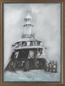
Painting - Pastel painting of the Gellibrand Light, Gellibrand Light
The reef off Point Gellibrand at Williamstown was lit for nearly 120 years by a series of lights, beginning with three separate lightships over the mid-late 1800s, to a pile light which lasted seventy years before it was dramatically destroyed when hit by a ship the Melbourne Trader on the foggy morning of 21 June 1976.A pastel painting of the Gellibrand Pile Light made by Denise Clarke in 1999.Gellibrand Light; Denise '99point gellibrand pile light