Showing 233 items
matching black hill mine
-
 Bendigo Historical Society Inc.
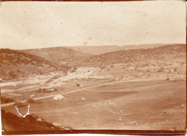
Newspaper - LONG GULLY HISTORY GROUP COLLECTION: BENDIGO - THE WAY WE WERE - LONG GULLY
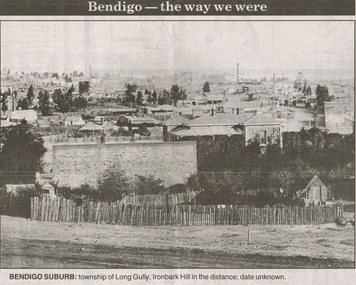
Black and white photo from Bendigo - the way we were series in the Bendigo Advertiser, November 14, 2000. The photo shows the township of Long Gully, Ironbark Hill in the distance. Date unknown. The photo shows houses, mine chimneys, trees and a rough picket type fence in the foreground.bendigo, history, long gully history group, the long gully history group - bendigo - the way we were - long gully, bendigo advertiser 14/11/2000, ironbark hill -
 Bendigo Historical Society Inc.
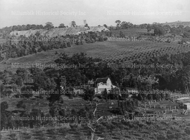
Photograph - LANDSCAPE VIEW OF BENDIGO: GREAT EXTENDED HUSTLERS MINE , CAMP HILL SCHOOL IN CENTRE
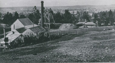
Black and white photo: landscape view of Bendigo valley looking towards One Tree Hill in distance. Great Extended Hustlers timber mine buildings, chimney and poppet head in foreground, trees middle ground, One Tree Hill in background. On back 'Mng10' In pencil - 'Great Extended Hustlers Freehold looking south, Moore St., just north of mine'. James Lerk ' From Hustlers Hill looking over Bendigo to One Tree Hill' late 19C, early 20C ?bendigo, gold mining, great extended hustlers, great extended hustlers mine, mining, one tree hill, camp hill primary school -
 Bendigo Historical Society Inc.
Postcard - GOLDEN SQUARE, BENDIGO FROM ' OLD CHUM' MINE
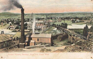
Postcard: hand coloured image showing mine site in Golden Square. Brick chimney in foreground, sheds. Tramway from LH side to poppet head behind chimney. On back of card ' Post GWW Card' Printed partly in Great Britain and partly in Germany. In black ink ' Dear Muncie Bob, I hope you arrived all right. I suppose you have started work before this. I don't start till 10th. Feb.' A stamp has been drawn, showing a house and written ' little house on the hill' Dated 1913.G.W.W.bendigo, mining, old chum mine, golden square, old chum mine, golden square, postcard -
 Bendigo Historical Society Inc.
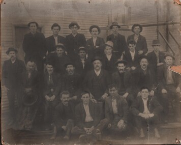
Photograph - DERBYSHIRE MINE PHOTO
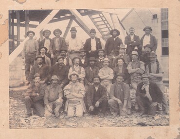
Black and white Photo of 28 Staff members from Derbyshire Mine. Includes miners and some better dressed, presumably managers, mounted on cardboard, markings on rear read 'Derbyshire Mine Shaft' 'N.W. Harrison Gladfield Park Pyramid Hill'organization, business, industrial, mine shaft, mining, miners, derbyshire mine, mines -
 Bendigo Historical Society Inc.
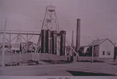
Photograph - LANSELL'S '180' MINE
Black and White Photograph of the Lansell's 180 Mine, Pictured in the Centre of the photo are 4 towers numbered 1-4 with Lansell's 180 written as well on tower 2, 'Piece of Paper contained with Photos could be the details of the possible donor reads 'Sandra McLachlan, 5 Chaple Cross Crt, Delecombe 3556, 0432 718 315, [email protected], 5336 1220'photograph, mining, lansell's 180 mine, mining, marong road, eaglehawk road, victoria hill, lansell, george lansell, christopher ballerstedt -
 Bendigo Historical Society Inc.
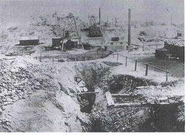
Photograph - VICTORIA HILL MINE
... PLACE Mining site victoria hill Mine - Victoria Hill ...Photograph - black and white. - A copy of a photograph. Written on the back of the photo - Victoria Hill - Ballerstedt Claim in centre foreground. Poppet heads in background. Two chimney stacks.place, mining site, victoria hill, mine - victoria hill. ballerstedt -
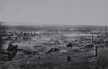
 Victorian Interpretive Projects Inc.
Photograph - Black and White, Ballarat, c1854
The town you see had over 50,000 people. Bridge Street on the left is well established. The crude pans and cradles of the early “diggers’ were already giving way to steam power and the deep shafts of the “miners”. Money and machinery were needed to get to the deeper leads, and the smoke stacks of the great company mines can be seen across the photo.Four black and white photographs placed together to make a panorama of Ballarat looking towards Mt Warrenheip. On the left the chimney and gasometer indicate the corner of Dana Street and Albert Street. This is now the Ballarat Law Courts. The photograph is behind glass in a black frame. These four photographs were taken from the slope of the Ballarat School of Mines where the Uniting Church now stands. When joined they give a panoramic view of one of the world’s richest alluvial goldfields. The Waterloo Mine was one of the first deep shafts and was sunk at the foot of the Dana Street hill. Its tailings are seen in the second photo from left. The following was typed and placed with the framed image. Ballarat Circa 1858 This is the most significant of the photographs of early Ballarat. The photographer stood on the slope near S.M.B. where the Wesley Church now stands and took four pictures. When joined them have this panoramic view of one of the world's richest alluvial goldfields. Seven years earlier this landscape was empty. The town you see had over 50,000 people. Bridge Street on the left is well established the Ballarat gas Company stands on the same place as today. The crude pans and cradles of the early "diggers" were already giving way to steam power and the deep shafts of the :"miners". Money and machinery were needed to get to the deeper leads, and the smoke stacks of the great company mines can be seen across the photo. The Waterloo mines was one of the first deep shafts and was sunk at the foot of the Dana Street hill. Its tailings are seen in the second photo from the left. ballarat, ballarat townscape, panorama, waterloo mine -
 Bendigo Historical Society Inc.
Photograph - NEW CHUM GOLDFIELDS MINE, EMPLOYEE PHOTO
Black and white photo, faded, pasted onto buff board. Possibly copy of original. Image shows 23 men standing and seated in front of corrugated iron mine shed. Men are dressed in suit coats and trousers, some wearing hats. Two men wearing collar and tie. On back of photo, written in pen : 'The photo of the New Chum Gold Fields Mine, Ddgiamond Hill, Bendigo, was taken about 1911, the Manager (Wilfred Rickards) seated in centre. There was a dozen or more mines in diamond Hill at that time. G.H. Furness, 116 High Street, Kangaroo Flat.'bendigo, mining, new chum goldfields mine -
 Bendigo Historical Society Inc.
Document - SETTLERS UNDER SAIL, 15/03/1918
Typed notes mentioning the history of the Hepburn Family and Margaret Cotton McLachlan coming by sailing ship to Australia to marry her fiance who was a miner in Sandhurst and extracts from the diary of William Thompson.document, names of bendigo pioneers, bendigo historical society, settlers under sail, alexander hepburn stone, loch ard centenary commemoration committee, professor j. j. auchmuty, mr don charlwood, andrew hepburn, james hepburn, mary queen of scots, black bothwell, captain hepburn, the 'hope', george b crow, george baker, the 'marlbro', archives department of the latrobe library, mr loman, the 'david clarke', captain hepburn of the royal scots, sir john hepburn, mr howard hepburn, victoria reef lease no 60, ebenezer neill, becker, stirton, margaret cotton mclachlan, ina hepburn, the 'donald mckay', black ball line, james baines and company of liverpool, onedin line, passenger contract ticket, james mclauchlan, christian ferguson, robert miller, william thompson, mr stanwin, the 'shomberg', itchell and son, the 'dunbar', margaret stirton, canon horace stirton, dr james nish, p pentreath, jane pentreath, st andrew's presbyterian church sandhurst, james hepburn, corporate high school, bendigo high school, iron bark school of john rae, rae's hill school, mr john rae, rae anderson, bendigo branch of the royal historical society of victoria, victoria reef mine, 'gourdie farm', mr howard hepburn, john fortey, margaret cotton hepburn -
 National Vietnam Veterans Museum (NVVM)
Ephemera - Order of Service, framed
Operation Hammersley , 10 February until 9 March 1970, was undertaken by a combined force of: C Company, 8th Battalion, the Royal Australian Regiment (8RAR); armoured personnel carriers from 3 Cavalry Regiment; tanks from 1 Armoured Regiment; sappers from the Royal Australian Engineers; a mortar section from 8RAR’s Support Company; air support, and even a Navy destroyer off-shore to provide gunfire support. The operation aimed to protect 17 Construction Squadron, Royal Australian Engineers, at a quarry in the western foothills of the Long Hai hills. The Long Hai hills were a stronghold for the Viet Cong, who used the caves there as a bunker complex and had planted many landmines and booby traps in the area. Over two fierce weeks, 8 RAR carried out patrols and conducted ambushes, engaging VC troops and eventually capturing the bunker system. However, it was a costly campaign. In total, over 70 Australians were killed or wounded during the operation. The worst day for mine casualties in Australia's war in Vietnam occurred on 28 February 1970. It became known as 'Black Saturday". Nine members of 8RAR were killed and 29 wounded. This item is the Order of Service from the memorial service held at Nui Dat on 3 April 1970 to honour those killed at Long Hai. It was issued to the donor, National Serviceman G G Ravenscroft, who was serving in 1 Platoon, A Company 8RAR during Operation Hammersley, and received a minor shrapnel wound on Black Saturday.Two typed A-4 pages that have been folded into booklet, now flattened and framed. Listed are the prayers, Bible readings and sermon given, along with the names of the 8 fallen soldiers, and the chaplains who officiated.8rar, long hai, long hai hills, black saturday, 1970, operation hammersley, ravenscroft, geoff ravenscroft, memorial service -
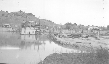
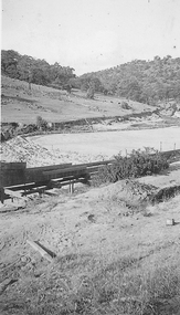 El Dorado Museum Association Inc.
Photograph (item) - Digital Image
Clear Creek Dammines, mining, tin, tin mining, sluicing, clear creek, el dorado, eldorado -
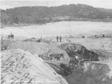 El Dorado Museum Association Inc.
Photograph (item) - Digital Image
Altering course of Reedy Creek, El Dorado. Cocks Pioneer Electric Gold & Tin Mine Company was formed in 1899. The company's first power station, located at the eastern end of the valley began operating with its 340 Kilowatt steam-powered generator. By 1909, from 2,500,000 cubic yards worked, reported recovery was 17,284 ounces of gold and 224 tons of tin ore. By 1909, Cocks Pioneer’s power plant had become inadequate and uneconomical. The barge was floated downstream about a mile, but lost time caused the operations to cease. Following testing, a new mine was established by diverting Reid's Creek at a cost of £25 000. Settling dams were built, one of which held 1,935,900 cubic feet. Sold earth banks, built against a wall of stringy bark saplings constructed and laced with vertical props, were built. In 1914, the company was reformed as Cock’s Pioneer Gold and Tin Mines NL, another power station was constructed at the western end of the township, near the junction of Clear and Reid's Creeks. From 6,800,000 cubic yards of material processed, the returns were 64,397 ounces of gold and 855 ton of tin. Cocks Pioneer mine then moved the barge downs stream and continued sluicing. In 1929 Cocks Pioneer Electric Gold and Tin Mining Company ceased operations due to a drop in values. Cock’s Pioneer Gold and Tin Mines NL carried on large-scale hydraulic sluicing operations until 1941. Handwritten across the front: 'Altering course of creek. Eldorado'mining, gold, tin, sluicing, reedy creek, cocks pioneer, el dorado, eldorado, men, horses -
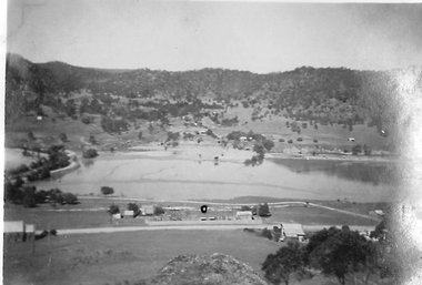 El Dorado Museum Association Inc.
Photograph (item) - Digital Image
Cocks Pioneer Ponds from Monument Hill. Cocks Pioneer Electric Gold & Tin Mine Company was formed in 1899. The company's first power station, located at the eastern end of the valley began operating with its 340 Kilowatt steam-powered generator. By 1909, from 2,500,000 cubic yards worked, reported recovery was 17,284 ounces of gold and 224 tons of tin ore. By 1909, Cocks Pioneer’s power plant had become inadequate and uneconomical. The barge was floated downstream about a mile, but lost time caused the operations to cease. Following testing, a new mine was established by diverting Reid's Creek at a cost of £25,000. Settling dams were built, one of which held 1,935,900 cubic feet. Sold earth banks, built against a wall of stringy bark saplings constructed and laced with vertical props, were built. In 1914, the company was reformed as Cock’s Pioneer Gold and Tin Mines NL, another power station was constructed at the western end of the township, near the junction of Clear and Reid's Creeks. From 6,800,000 cubic yards of material processed, the returns were 64,397 ounces of gold and 855 ton of tin. Cocks Pioneer mine then moved the barge downs stream and continued sluicing. In 1929 Cocks Pioneer Electric Gold and Tin Mining Company ceased operations due to a drop in values. Cock’s Pioneer Gold and Tin Mines NL carried on large-scale hydraulic sluicing operations until 1941. mining, gold, tin, hydraulic, sluicing, gold mining, tin mining, monument hill, cocks pioneer, el dorado, eldorado -
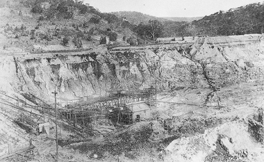
 El Dorado Museum Association Inc.
Photograph (item) - Digital Image
Cocks Pioneer Barge. Cocks Pioneer Electric Gold & Tin Mine Company was formed in 1899. The company's first power station, located at the eastern end of the valley began operating with its 340 Kilowatt steam-powered generator. By 1909, from 2,500,000 cubic yards worked, reported recovery was 17,284 ounces of gold and 224 tons of tin ore. By 1909, Cocks Pioneer’s power plant had become inadequate and uneconomical. The barge was floated downstream about a mile, but lost time caused the operations to cease. Following testing, a new mine was established by diverting Reid's Creek at a cost of £25,000. Settling dams were built, one of which held 1,935,900 cubic feet. Sold earth banks, built against a wall of stringy bark saplings constructed and laced with vertical props, were built. In 1914, the company was reformed as Cock’s Pioneer Gold and Tin Mines NL, another power station was constructed at the western end of the township, near the junction of Clear and Reid's Creeks. From 6,800,000 cubic yards of material processed, the returns were 64,397 ounces of gold and 855 ton of tin. Cocks Pioneer mine then moved the barge downs stream and continued sluicing. In 1929 Cocks Pioneer Electric Gold and Tin Mining Company ceased operations due to a drop in values. Cock’s Pioneer Gold and Tin Mines NL carried on large-scale hydraulic sluicing operations until 1941. mining, gold, tin, barge, sluicing, gold mining, tin mining, cocks pioneer, el dorado, eldorado -
 El Dorado Museum Association Inc.
Photograph (item) - Digital Image
Cocks Pioneer Electric Gold & Tin Mine Company was formed in 1899. The company's first power station, located at the eastern end of the valley began operating with its 340 Kilowatt steam-powered generator. By 1909, from 2,500,000 cubic yards worked, reported recovery was 17,284 ounces of gold and 224 tons of tin ore. By 1909, Cocks Pioneer’s power plant had become inadequate and uneconomical. The barge was floated downstream about a mile, but lost time caused the operations to cease. Following testing, a new mine was established by diverting Reid's Creek at a cost of £25,000. Settling dams were built, one of which held 1,935,900 cubic feet. Sold earth banks, built against a wall of stringy bark saplings constructed and laced with vertical props, were built. In 1914, the company was reformed as Cock’s Pioneer Gold and Tin Mines NL, another power station was constructed at the western end of the township, near the junction of Clear and Reid's Creeks. From 6,800,000 cubic yards of material processed, the returns were 64,397 ounces of gold and 855 ton of tin. Cocks Pioneer mine then moved the barge downs stream and continued sluicing. In 1929 Cocks Pioneer Electric Gold and Tin Mining Company ceased operations due to a drop in values. Cock’s Pioneer Gold and Tin Mines NL carried on large-scale hydraulic sluicing operations until 1941. mines, mining, tin, gold, tin mining, gold mining, sluicing, cocks pioneer, el dorado, eldorado -
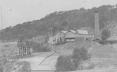 El Dorado Museum Association Inc.
Photograph - Digital Image
Cocks Pioneer Power Station No 1. Cocks Pioneer Electric Gold & Tin Mine Company was formed in 1899. The company's first power station, located at the eastern end of the valley began operating with its 340 Kilowatt steam-powered generator. By 1909, from 2 500 000 cubic yards worked, reported recovery was 17 284 ounces of gold and 224 tons of tin ore. By 1909, Cocks Pioneer’s power plant had become inadequate and uneconomical. The barge was floated downstream about a mile, but lost time caused the operations to cease. Following testing, a new mine was established by diverting Reid's Creek at a cost of £25 000. Settling dams were built, one of which held 1 935 900 cubic feet. Sold earth banks, built against a wall of stringy bark saplings constructed and laced with vertical props, were built. In 1914, the company was reformed as Cock’s Pioneer Gold and Tin Mines NL, another power station was constructed at the western end of the township, near the junction of Clear and Reid's Creeks. From 6,800,000 cubic yards of material processed, the returns were 64 397 ounces of gold and 855 ton of tin. Cocks Pioneer mine then moved the barge downs stream and continued sluicing. In 1929 Cocks Pioneer Electric Gold and Tin Mining Company ceased operations due to a drop in values. Cock’s Pioneer Gold and Tin Mines NL carried on large-scale hydraulic sluicing operations until 1941. Handrwitten on right side of image: PIONEER MINE ELDORADO Handwritten on left side of image: AJ EVANS PHOTO / WANGARATTAmines, mining, gold, tin, gold mining, tin mining, sluicing, hydraulic mining, energy, power station, cocks pioneer, el dorado, eldorado -
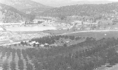 El Dorado Museum Association Inc.
Photograph - Digital Image
C Rankins Almond Orchard & Cocks Pioneer Pond, 1930s. Cocks Pioneer Electric Gold & Tin Mine Company was formed in 1899. The company's first power station, located at the eastern end of the valley began operating with its 340 Kilowatt steam-powered generator. By 1909, from 2 500 000 cubic yards worked, reported recovery was 17 284 ounces of gold and 224 tons of tin ore. By 1909, Cocks Pioneer’s power plant had become inadequate and uneconomical. The barge was floated downstream about a mile, but lost time caused the operations to cease. Following testing, a new mine was established by diverting Reid's Creek at a cost of £25 000. Settling dams were built, one of which held 1 935 900 cubic feet. Sold earth banks, built against a wall of stringy bark saplings constructed and laced with vertical props, were built. In 1914, the company was reformed as Cock’s Pioneer Gold and Tin Mines NL, another power station was constructed at the western end of the township, near the junction of Clear and Reid's Creeks. From 6,800,000 cubic yards of material processed, the returns were 64 397 ounces of gold and 855 ton of tin. Cocks Pioneer mine then moved the barge downs stream and continued sluicing. In 1929 Cocks Pioneer Electric Gold and Tin Mining Company ceased operations due to a drop in values. Cock’s Pioneer Gold and Tin Mines NL carried on large-scale hydraulic sluicing operations until 1941. mines, mining, farms, farming, almonds, sluicing, rankins, cocks pioneer, el dorado, eldorado -
 El Dorado Museum Association Inc.
Photograph - Digital Image
Cocks Pioneer, East El Dorado, early 1920s. Cocks Pioneer Electric Gold & Tin Mine Company was formed in 1899. The company's first power station, located at the eastern end of the valley began operating with its 340 Kilowatt steam-powered generator. By 1909, from 2 500 000 cubic yards worked, reported recovery was 17 284 ounces of gold and 224 tons of tin ore. By 1909, Cocks Pioneer’s power plant had become inadequate and uneconomical. The barge was floated downstream about a mile, but lost time caused the operations to cease. Following testing, a new mine was established by diverting Reid's Creek at a cost of £25 000. Settling dams were built, one of which held 1 935 900 cubic feet. Sold earth banks, built against a wall of stringy bark saplings constructed and laced with vertical props, were built. In 1914, the company was reformed as Cock’s Pioneer Gold and Tin Mines NL, another power station was constructed at the western end of the township, near the junction of Clear and Reid's Creeks. From 6,800,000 cubic yards of material processed, the returns were 64 397 ounces of gold and 855 ton of tin. Cocks Pioneer mine then moved the barge downs stream and continued sluicing. In 1929 Cocks Pioneer Electric Gold and Tin Mining Company ceased operations due to a drop in values. Cock’s Pioneer Gold and Tin Mines NL carried on large-scale hydraulic sluicing operations until 1941. mines, mining, gold, gold mining, cocks pioneer, sluicing, el dorado, eldorado -
 Nillumbik Historical Society Incorporated
Photograph - Black & white photograph, Primitive Methodist Church and School with Diamond Creek Gold Mine on hill above
... Church and School with Diamond Creek Gold Mine on hill above ...The earliest known photograph of Patrick Cummings barn - the Primitive Methodist Church and School and the Diamond Creek Gold Mine both established in the early 1860's.Black & white photographnoneprimitive methodist church, methodist church, diamond creek school, nillumbik school -
 Clunes Museum
Photograph, 1859
.1.2 BLACK AND WHITE PHOTOGRAPH OF PORT PHILLIP HILL TAKEN CIRCA 1859. .1 HANDWRITTEN ON BACK: PORT PHILLIP MINE AND HILL TAKEN CIRCA 1859 PORT PHILLIP MINE SOUTH SHAFT CLUNES HOTEL IN MIDDLE OF P.P. PADDOCK CLUNES UNITED MINE CRITERIAN MINE CRITERIAN BRIDGE WOOSTERS BALLARAT RESTAURANT, DOES NOT SHOW IN LATER PICTURES PORT PHILLIP MINE FIRST BATTERY PORT PHILLIP HOTEL OPENED IN 1859, CONTINUED UNTIL LATE 1890'S CRITERION HOTEL, FIRST MASONIC MEET UP, BURNT JAN 1871 NEGATIVE OF THIS PHOTO IS AT LATROPE LIBRARY MELBOURNE SIGNED: J CONRAD WEICKHARDT .2 HANDWRITTEN ON BACK: PHOTO OF PORT PHILLIP MINE AND HILL TAKEN ABOUR 1859 OR 1860 THE NEGATIVE OF THIS PICTURE IS AT LATROBE LIBRARY MELBOURNE FROM CAMP PARADE photography, mining, port phillip hill, port phillip -
 Clunes Museum
Photograph - PHOTOGRAPH PORT PHILLIP MINE 1880
BLACK AND WHITE PHOTOGRAPH / PANORAMIC VIEW BATTERY , PORT PHILLIP MINE TAKEN FROM CAMP HILL 1880.photography, port phillip mine, battery port phillip mine -
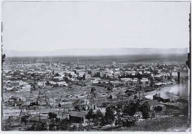
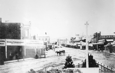 Stawell Historical Society Inc
Photograph, Main Street looking East from Coffee Palace area 1880
Main Street Looking East 1880 from weigh bridge area, taken from Coffee Palace verandah. Two story buildings with veranda's. Horse drawn vehicle center of image. Post office and Town Hall visible in background. Bond Drapery. J & A Price Wine Spirits. Bond Draper sign on right. Two Poppet Heads on Big Hill are the No2 North Waterloo and the Waterloo and Argyle Mines.Black and white photograph looking East along Main Street from Weighbridge area where two streets join. Horse drawn buggy in center of street with buggy. Big Hill in distance with two poppet heads just visible.stawell businesses streetscape -
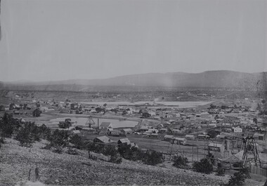
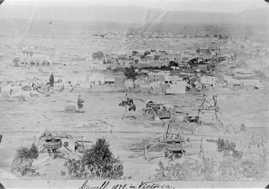 Stawell Historical Society Inc
Photograph, Panorama of Stawell from Big Hill 1878, North Scotchmans No6 and No7 and South Cross Mine whims and Poppet Heads
Scene from Big Hill. Shows Stawell looking to West c 1878 Patrick Streets and Sloane Street intersection. Back of Royal Exchange Hotel Kays Foundry in Wimmera Street. Coffee Palace formerly Castlemaine Hotel at right of photo. Mining poppet heads in foreground Three Whims in the foreground are North Scotchmans No 6 & 7 and South Cross in CentreSepia toned print & also a Black & White print (these photos are similar to 29.9). Photos show Western view of mining activity in Stawell c 1878. Kays Foundry on upper left and Upper Main Street on very right of photo.Stawell 1878 in Victoria.stawell, mining, panorama, streatscape -
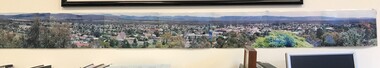 Stawell Historical Society Inc
Photograph, Panorama of Stawell from Big Hill c 1998 -- Coloured
Colour Panorama of Stawell c 1998 Overlooking Stawell. Black Range and Grampians visible in background. Panorama photo was taken by Irene Read for Barbara Bennet, a member of the "Big Hill Action Group" The group were fighting Stawell Gold Mines proposal to "Open Pit" the Big Hill area. SGM was at that time owned by an American Company - Pitston-Brinks. Laminated panorama of Stawell from Big Hill c 1998 -- Coloured photographs producing a panorama of Stawell. stawell, panorama -
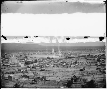 Stawell Historical Society Inc
Photograph, View of Stawell from Big Hill April 1874 showing mines centered on St Georges Crushing Mill -- 5 Photos
From left Reefs Restaurant, T. Hogan & Co Tea Wine Spirits Merchant, R. Hepburn Carolina Hotel, Pleasant Creek Hotel, St George Stamping Battery, Free Methodist Chapel Church, Ballarat Hotel, Woodcock Produce Grocer, Stawell Brewery in far distance, L. Thomas Wheelwright Farrier & General Blacksmith, Australian Hotel, G. Laing Bootmaker, Brierly & Wilson Greengrocer, P. Corkeron Bootmaker, P. Corkeron Wholesale Retail General Grocer, Globe Hotel in distance, Christ Church.Part of Holtermann Collection. Black and White photograph of Stawell from Big Hill with mining in foreground. April 1874. View covers from St Patrick's Church to current location of Police Station along Patrick Street. St George Crushing Mill near Centre of Photograph. Includes Carolina Hotelmining, panorama -
 Stawell Historical Society Inc
Photograph, View of Stawell from Big Hill 1874 photo showing mines at North end of Stawell -- Looking towards Briggs Bluff -- 2 Photos
Black and White photograph of Stawell from Big Hill with mining in foreground and Moonlight evaporation dams. Holtermann photograph Taken April 1874mining, panorama -
 Stawell Historical Society Inc
Photograph, View of Stawell from Big Hill April 1874 showing mines centered on north end of Main Street -- 2 Photos
From left Shire Hall Pleasant Creek in distance, Mathers & Franklin, Stawell Coach Factory, Coffee Palace, Christ Church of England Church Hill, Mechanics Institute, Temperance Hotel, Matherson Cross Reef Hotel.Black and White Holtermann photograph of Stawell from Big Hill with mining in foreground. 1874 Site of fire in Main and Street Patrick Street 22 April 1874 visible in centre of photograph.mining, panorama, streetscape -
 Stawell Historical Society Inc
Photograph, View of Stawell from Big Hill 1874 showing mines looking towards South end of Black range -- 4 Photos
Visible Nelsons Criterion Hotel, Wimmera Crushing Mill, Odd Fellows Arms hotel, F.H. Oliver & Co Grain Merchant, Reefs Restaurant.Holtermann Black and White photograph of Stawell from Big Hill with mining in foreground. April 1874. Wimmera Crushing Mill and settling pond at centre of photograph. Stawell water supply centre left of photo. Black Range in Background.mining, panorama -
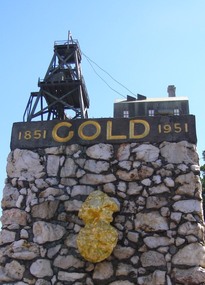 Ballarat Heritage Services
Photograph, Dorothy Wickham, Gold Monument, Ballarat, c2010
Gold was discovered in Ballarat in 1851 when many people rushed to the diggings. A monument commemorates the centenary of the finding of gold at Poverty Point and is dedicated to the memory of pioneer miners of Ballarat. It records gold yields, nuggets and the richest recorded yields of both alluvial and quartz mines. The replica gold nugget on the monument is the `Welcome Nugget`, found in Ballarat in 1858, weighed 2,217 ounces and was sold for £10,500. The memorial, known as the Pioneer Miners’ Monument, was made to commemorate Ballarat's gold centenary. It was proposed that part of the Pioneers' Memorial Fund might be used. This fund was started with £1300 profit from the 1938 centenary celebrations. (Age (Melbourne), The monument was created by John Edward Skilbeck, a toolmaker with Ronaldson and Tippett. John Skilbeck had a deep interest in Ballarat History, and undertook much research with Bert Strange and Keith Stacpoole. Councilllor William Ernest Roff provided the copper for the memorial from scrap copper obtained during his plumbing business. The copper was reworked by John Skilbeck, and was soldered in the kitchen of his home at 14 Frank Street. Colour photograph of the gold monument on the corner of Sturt Street and Albert Street, Ballarat. It commemorates the discovery of gold at Poverty Point in August 1851, and was The monument was unveiled in 1951 and is mainly constructed of large piecesof quartz, with a miniature popper head on the top made of copper. Mounted on the side is a replica of the Welcome Nugget, which was unearthed on the corner of Humffray and Mair Streets, Ballarat on 09 June 1858.FRONT This monument was erected by the Ballarat Historical Society to commemorate the finding of gold at Poverty Point 21st August 1851 and is dedicated to the memory of/ pioneer miners of Ballarat LEFT SIDE Richest recorded yields alluvial mines Band of Hope 303269 Ozs Prince of Wales 168929 Koh I Noor 164157 Great Redan Ex 110111 Albion 107125 Bonshaw Fr 96520 Park 94699 St George 86702 Sir Wm Don 76830 Hand in Hand 76830 Sir Henry Loch 43562 Quartz Mines Star of the East 256758 Ozs Band of Hope 158299 Victoria United 152013 N Woah Hawp 129562 New Normanby 127562 Britannia 103225 Llanberris No 1 100533 Black Hill 91665 Last Chance U 83766 Llanberris 71364 Speedwell 66000 South Star 64444 Sulieman Pasha Companies 62666 RIGHT Recorded gold yield 20606000 ozs Nuggets Alluvial Welcome 2217 ozs Saraha Snads 1619 Lady Hotham 1177 Canadian 1 1117 Canadian 2 1011 Koh 1 Noor 834 Eureka 625 Lady Loch 617 Prince of Wales 606 Bakery Hill 571 Native Youth 540 Faboulous yields of earliest diggings not offically recorded Quartz Nuggets N Woah Hawp 5-- 300 200 Ozs White Horse 500 Woah Hawp 444 266 262 Canton 257 200 Q Victoria lease 410 U Black Hill Coy 315 Tinworths 250 Parade Coy 245gold monument, ballarat, skilbeck, poppet head, j.e. skilbeck, john skilbeck -
 Ballarat Heritage Services
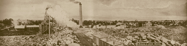
Photograph - Image - Black and White, Band and Loch Mine, c1904, c1904
Black and white panoramic view of the Band and Loch mine. ballarat, goldfield, mining, band and loch mine, redan