Showing 153 items
matching bridge over yarra river
-
 Eltham District Historical Society Inc
Photograph, Yarra River from Henley Bridge, Kangaroo Ground, Spring Excursion, Exploring the Upper Yarra, 22 October 1995, 22/10/1995
[article by Bettina Woodburn in EDHS Newsletter No. 105, November 1995:] EXPLORING THE UPPER YARRA - We enjoyed the Spring Excursion, this year "Exploring the Upper Yarra" - in spite of the constant rain and the countryside under the cloud cover, especially in the valleys, being mainly shiny shades of green. The occasional fields of buttercups, clumps of arum lilies and splendid rhododendron and other flowering bushes became very special. The Cobb and Co coach was warm and a cosy retreat as we zig-zagged on the highways and byways to glimpse the Yarra River, upstream and down, its secret places, and particularly the many bridges. Russell excelled as 'Poet Laureate', reading from Dacre Smyth's book. This 1979 publication includes paintings of all the bridges along the river with poems and brief descriptions of each one. Some of the bridges are in out-of-the-way places and are not very well known. We looked forward to hearing the poetry as much as seeing the 'constructions'… Big Pat (was he short or tall, lean or fat? - he did win the £200 reward for discovering gold and had the creek named after him), about the 'Eddies'?, and the disliked 'meccano' bridge in Warburton, etc. etc. The hot roast lunch in the old Reefton Hotel was also most welcome. It was easy to imagine it peopled by miners and early settlers. Starting by crossing the new (1974) concrete bridge at Warrandyte we headed through Wonga Park with views to the Christmas Hills and to the escarpment of the Yering Gorge, which causes flood waters to back up through the Yarra Glen plain, so avoiding disasters downstream. At the end of a long driveway we found the wooden, privately owned Henley Bridge (1935 after the 1934 floods). This facilitates access to different parts of Henley Farm and to Lilydale. Everard Park, named after Blanche Shallard's father, a State Member for 17 years, below the Highway Yarra crossing was in need of care. It is 10 miles from Yarra Glen by road but, as "Yarra Marra” canoeists well know, 32 winding miles down by water. After more delightful countryside scenes we joined the Warburton Highway at Woori Yallock. From the old Railway Station at Launching Place the Centennial Trail for walkers, cyclists and horse riders has replaced the rails. The line from Lilydale was opened in 1901, and the last diesel freight train ran to Warburton in 1965. It continued to rain as we had morning tea in Warburton in a shelter between footbridges. From here we continued upstream past the Bridge to O'Shannassy Lodge and Reservoir, Starvation Creek, and the Peninsular tunnel (miners dug it as at Pound Bend) which we visited (scrambling down those steps!) on our return after lunch. Our furthermost point was the Upper Yarra Dam Reserve (and vast catchment area). Finished in 1957 after ten years' work and 100 years after Yan Yean, it supplies much of Melbourne's water. After crossing the 30m Launching Place Bridge to the Eltham side of the Yarra and Healesville, we saw in the distance the Yarra Glen Timber Trestle Bridge over the river flats "the longest for years in the land it was said!" Harry's dream of "better weather over the Divide" unfortunately didn't come true, but I'm sure we 36 members will retain happy memories of a day that was wet and green and filled with Bridges.Colour photographactivities, upper yarra, henley bridge -
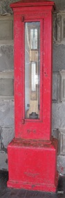 Flagstaff Hill Maritime Museum and Village
Instrument - Barometer, 1867
Langlands Company History: Langlands foundry was Melbourne's first foundry and iron shipbuilder established in 1842, only 8 years after the founding of the Victorian colony by two Scottish immigrants, Robert Langlands and Thomas Fulton, who had formed a partnership before emigrating (1813–1859). The business was known as the 'Langlands Foundry Co'. Henry Langlands (1794-1863), left Scotland in 1846 with his wife Christian, née Thoms, and five surviving children to join his brother Robert. By the time he arrived in early January of 1847 the partnership of Robert Langlands and Fulton had dissolved as Fulton had gone off to establish his own works. It was at this time that the two brothers took over ownership of Langlands foundry. Several years later Robert retired and Henry became sole the proprietor. The foundry was originally located on Flinders Lane between King and Spencer streets. Their sole machine tool, when they commenced as a business, was a small slide rest lathe turned by foot. In about 1865 they moved to the south side of the Yarra River, to the Yarra bank near the Spencer Street Bridge and then in about 1886 they moved to Grant Street, South Melbourne. The works employed as many as 350 workers manufacturing a wide range of marine, mining, civil engineering, railway and general manufacturing components including engines and boilers. The foundry prospered despite high wages and the lack of raw materials. It became known for high-quality products that competed successfully with any imported articles. By the time Henry retired, the foundry was one of the largest employers in Victoria and was responsible for casting the first bell and lamp-posts in the colony. The business was carried on by his sons after Henry's death. The company was responsible for fabricating the boiler for the first railway locomotive to operate in Australia, built-in 1854 by Robertson, Martin & Smith for the Melbourne and Hobson's Bay Railway Company. Also in the 1860s, they commenced manufacture of cast iron pipes for the Board of Works, which was then laying the first reticulated water supply system in Melbourne. Langlands was well known for its gold mining equipment, being the first company in Victoria to take up the manufacture of mining machinery, and it played an important role in equipping Victoria's and Australia's first mineral boom in the 1850s and 1860s. Langlands Foundry was an incubator for several engineers including Herbert Austin (1866–1941) who worked as a fitter at Langlands and went on to work on the Wolesely Shearing machine. He also founded the Austin Motor Company in 1905. Around the 1890s Langlands Foundry Co. declined and was bought up by the Austral Otis Co. in about 1893. History for Grimoldi: John Baptist Grimoldi was born in London UK. His Father was Domeneck Grimoldi, who was born in Amsterdam with an Italian Father and Dutch mother. Domeneck was also a scientific instrument maker. John B Grimoldi had served his apprenticeship to his older brother Henry Grimoldi in Brooke Street, Holburn, London and had emigrated from England to Australia to start his own meteorological and scientific instrument makers business at 81 Queens St Melbourne. He operated his business in 1862 until 1883 when it was brought by William Samuel and Charles Frederick, also well known scientific instrument makers who had emigrated to Melbourne in 1875. John Grimoldi became successful and made a number of high quality measuring instruments for the Meteorological Observatory in Melbourne. The barometer was installed at Warrnambool's old jetty and then the Breakwater as part of the Victorian Government's insistence that barometers be placed at all major Victorian ports. This coastal barometer is representative of barometers that were installed through this government scheme that began in 1866. The collecting of meteorological data was an important aspect of the Melbourne Observatory's work from its inception. Just as astronomy had an important practical role to play in navigation, timekeeping and surveying, so the meteorological service provided up to date weather information and forecasts that were essential for shipping and agriculture. As a result, instruments made by the early instrument makers of Australia was of significant importance to the development and safe trading of companies operating during the Victorian colonies early days. The provenance of this artefact is well documented and demonstrates, in particular, the importance of the barometer to the local fishermen and mariners of Warrnambool. This barometer is historically significant for its association with Langlands’ Foundry which pioneered technology in the developing colony by establishing the first ironworks in Melbourne founded in 1842. Also, it is significant for its connection to John B Grimoldi who made the barometer and thermometer housed in the cast iron case. Grimoldi, a successful meteorological and scientific instrument maker, arrived in the colony from England and established his business in 1862 becoming an instrument maker to the Melbourne Observatory. Additional significance is its completeness and for its rarity, as it is believed to be one of only two extant barometers of this type and in 1986 it was moved to Flagstaff Hill Maritime Village as part of its museum collection. Coast Barometer No. 8 is a tall, red painted cast iron pillar containing a vertical combined barometer and thermometer. Half way down in the cast iron framed glass door is a keyhole. Inside is a wooden case containing a mercury barometer at the top with a thermometer attached underneath, each with a separate glass window and a silver coloured metal backing plate. Just below the barometer, on the right-hand side, is a brass disc with a hole for a gauge key in the centre. The barometer has a silvered tin backing plate with a scale, in inches, of "27 to 31" on the right side and includes a Vernier with finer markings, which is set by turning the gauge key. The thermometer has a silvered tin backing plate with a scale on the left side of "30 to 140". Each of the scales has markings showing the units between the numbers.Inscription at the top front of the pillar reads "COAST BAROMETER" Inscribed on the bottom of the pillar is "No 8". and "LANGLANDS BROS & CO ENGINEERS MELBOURNE " The barometer backing plate is inscribed "COAST BAROMETER NO. 8, VICTORIA" and printed on the left of the scale, has "J GRIMOLDI" on the top and left of the scale, inscribed "Maker, MELBOURNE". There is an inscription on the bottom right-hand side of the thermometer scale, just above the 30 mark "FREEZING" Etched into the timber inside the case are the Roman numerals "VIII" (the number 8)flagstaff hill, warrnambool, maritime village, maritime museum, flagstaff hill maritime museum & village, shipwreck coast, great ocean road, warrnambool breakwater, coast barometer, coastal barometer, barometer, weather warning, ports and harbours, fishery barometer, sea coast barometer, austral otis co, coast barometer no. 8, henry grimoldi, henry langlands, john baptist grimoldi, langlands foundry co, meteorological instrument maker, robert langlands, scientific instrument maker, thermometer, thomas fulton -
 Eltham District Historical Society Inc
Negative - Photograph, Russell Yeoman, Para Road / Carter Street Bridge over the Plenty River, Briar Hill, c.Jul. 1969
Bridge over the Plenty River at Briar Hill before widening and alterations. The Plenty River at Briar Hill represented the boundary between the Shire of Eltham and the Shire of Diamond Valley. The bridge was known as the Carter Street Bridge as prior to 1969 Para Road, Briar Hill became Carter Street, Greensborough across the river. It was at this time that the name Para Road was continued and replaced Carter Street.This photo forms part of a collection of photographs gathered by the Shire of Eltham for their centenary project book,"Pioneers and Painters: 100 years of the Shire of Eltham" by Alan Marshall (1971). The collection of over 500 images is held in partnership between Eltham District Historical Society and Yarra Plenty Regional Library (Eltham Library) and is now formally known as the 'The Shire of Eltham Pioneers Photograph Collection.' It is significant in being the first community sourced collection representing the places and people of the Shire's first one hundred years.Digital image 35 mm B&W negativeshire of eltham pioneers photograph collection, briar hill, 1969-07, bridge, carter street bridge, para road, para road bridge, plenty river, shire of diamond valley, shire of eltham -
 Eltham District Historical Society Inc
Negative - Photograph, Carl Walter 1831-1907, Coffer dam in the Yarra River at Anderson's Creek, 1864
1864 photograph of the Coffer Dam in the River Yarra situated (approximately) opposite Whipstick Gully. Remains of bridge built in 1860(?) wrecked by 1863 flood in background. Reproduced page 29 of ‘Pioneers & Painters’ Gold was first discovered in this area at Andersons Creek (Warrandyte) in June 1851 by Louis Michel. Discoveries north of the Yarra did not occur until about 1854. Although it took some months for a true rush to develop it was not long before alluvial workings were being carried on in most of the Shire of Eltham. The last area in which gold was discovered was Kinglake. As the gold became harder to find, deep mining took over from alluvial diggings in the gullies. Perhaps the most extensive of the deep workings was the Diamond Creek Mine just outside the boundary of the Shire. This form of mining was continued into the 1930s. There are believed to be some mines in the area still capable of producing gold but present prices make working these uneconomical. Some gold is still found by weekend prospectors. Photo: Carl Walter 1831-1907 – inscribed on tent “C. Walter Photo” The State Library of Victoria holds over 150 photos by Carl Walter, most of which are portraits of Aboriginal natives including William Barak.This photo forms part of a collection of photographs gathered by the Shire of Eltham for their centenary project book,"Pioneers and Painters: 100 years of the Shire of Eltham" by Alan Marshall (1971). The collection of over 500 images is held in partnership between Eltham District Historical Society and Yarra Plenty Regional Library (Eltham Library) and is now formally known as 'The Shire of Eltham Pioneers Photograph Collection.' It is significant in being the first community sourced collection representing the places and people of the Shire's first one hundred years.Digital image 4 x 5 inch B&W Neg (2) Print 20 x 25 cmshire of eltham pioneers photograph collection, anderson's creek, coffer dam, floods, gold mining, other areas, pioneers and painters, warrandyte, warrandyte bridge, yarra river -
 Eltham District Historical Society Inc
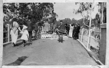
Photograph, Hurstbridge - Cr. Price crossing New Bridge (Opening Day), 1917, 1917
Eltham Shire Councillor Albert Price joined over 500 spectators for the official opening of the new re-inforced concrete bridge across the Diamond Creek at Hurstbridge. Eltham Shire shared the cost of the construction of the bridge with Heidelberg and Whittlesea Shires.This photo forms part of a collection of photographs gathered by the Shire of Eltham for their centenary project book, "Pioneers and Painters: 100 years of the Shire of Eltham" by Alan Marshall (1971). The collection of over 500 images is held in partnership between Eltham District Historical Society and Yarra Plenty Regional Library (Eltham Library) and is now formally known as 'The Shire of Eltham Pioneers Photograph Collection.' It is significant in being the first community sourced collection representing the places and people of the Shire's first one hundred years.Digital imagesepp, shire of eltham pioneers photograph collection, diamond creek, hurstbridge, wattle glen, bridge, councilor price, opening day, diamond creek (river) -
 Eltham District Historical Society Inc
Negative - Photograph, J. P. Lind, Hurst's Bridge, 1885
Looking northwest onto the first bridge at Hurstbridge, 1885. Timber bridge amid rural setting. Two horses graze in an open paddock in the foreground. A house is situated on a rise behind the bridge on a tree lined hill. The area of Hurstbridge was originally known as Hurst’s-bridge after the timber bridge built over the Diamond Creek near Hurst’s station in late 1881/early 1882 on the Hurstbridge-Arthurs Creek Road, Hurstbridge. It was built by John McDonald, of Arthur's Creek and was demolished and replaced in 1917 by a reinforced concrete arch bridge designed by John Monash. Cross Reference Photo No.(s): 1012/1013This photo forms part of a collection of photographs gathered by the Shire of Eltham for their centenary project book, "Pioneers and Painters: 100 years of the Shire of Eltham" by Alan Marshall (1971). The collection of over 500 images is held in partnership between Eltham District Historical Society and Yarra Plenty Regional Library (Eltham Library) and is now formally known as 'The Shire of Eltham Pioneers Photograph Collection.' It is significant in being the first community sourced collection representing the places and people of the Shire's first one hundred years.Digital image 4 x 5 inch B&W Negshire of eltham pioneers photograph collection, hurstbridge, bridge, diamond creek (river), diamond creek (creek), hurst's bridge -
 Eltham District Historical Society Inc
Photograph, Peter Bassett-Smith, Upper Yarra Dam, Spring Tour, 22 Oct 1995, 22/10/1995
EXPLORING THE UPPER YARRA (Newsletter No. 105, November 1995, by Bettina Woodburn) We enjoyed the Spring Excursion, this year "Exploring the Upper Yarra" - in spite of the constant rain and the countryside under the cloud cover, especially in the valleys, being mainly shiny shades of green. The occasional fields of buttercups, clumps of arum lilies and splendid rhododendron and other flowering bushes became very special. The Cobb and Co coach was warm and a cosy retreat as we zig-zagged on the highways and byways to glimpse the Yarra River, upstream and down, its secret places, and particularly the many bridges. Russell excelled as 'Poet Laureate', reading from Dacre Smyth's book. This 1979 publication includes paintings of all the bridges along the river with poems and brief descriptions of each one. Some of the bridges are in out of the way places and are not very well known. We looked forward to hearing the poetry as much as seeing the ' constructions'…Big Pat (was he short or tall, lean or fat? He did win the two hundred pound reward for discovering gold and had the creek named after him), about the 'Eddies'?, and the disliked 'meccano' bridge in Warburton, etc. etc. The hot roast lunch in the old Reefton Hotel was also most welcome. It was easy to imagine it peopled by miners and early settlers. Starting by crossing the new (1974) concrete bridge at Warrandyte we headed through Wonga Park with views to the Christmas Hills and to the escarpment of the Yering Gorge, which causes flood waters to back up through the Yarra Glen plain, so avoiding disasters downstream. At the end of a long driveway we found the wooden, privately owned Henley Bridge (1935 after the 1934 floods). This facilitates access to different parts of Henley Farm and to Lilydale. Everard Park, named after Blanche Shallard's father, a State Member for 17 years, below the Highway Yarra crossing was in need of care. It is 10 miles from Yarra Glen by road but, as "Yarra Marra” canoeists well know, 32 winding miles down by water. After more delightful countryside scenes we joined the Warburton Highway at Woori Yallock. From the old Railway Station at Launching Place the Centennial Trail for walkers, cyclists and ' horse riders has replaced the rails. The line from Lilydale was opened in 1901, and the last diesel freight train ran to Warburton in 1965. It continued to rain as we had morning tea in Warburton in a shelter between footbridges. From here we continued upstream past the Bridge to O'Shannasy Lodge and Reservoir, Starvation Creek, and the Peninsular tunnel (miners dug it as at Pound Bend) which we visited (scrambling down those steps!) on our return after lunch. Our furthermost point was the Upper Yarra Dam Reserve (and vast catchment area). Finished in 1957 after ten years work and 100 years after Yan Yean, it supplies much of Melbourne's water. After crossing the 30m Launching Place Bridge to the Eltham side of the Yarra and Healesville, we saw in the distance the Yarra Glen Timber Trestle Bridge over the river flats "the longest for years in the land it was said!" Harry's dream of "better weather over the Divide" unfortunately didn't come true, but I'm sure we 36 members will retain happy memories of a day that was wet and green and filled with Bridges. Bettina Woodburn - October 1995 Record of the Society's history of activities - Spring 1995 excursionColour photographactivities, upper yarra dam, 1995, peter bassett-smith -
 Eltham District Historical Society Inc
Photograph, Peter Bassett-Smith, Upper Yarra Dam, Spring Tour, 22 Oct 1995, 22/10/1995
EXPLORING THE UPPER YARRA (Newsletter No. 105, November 1995, by Bettina Woodburn) We enjoyed the Spring Excursion, this year "Exploring the Upper Yarra" - in spite of the constant rain and the countryside under the cloud cover, especially in the valleys, being mainly shiny shades of green. The occasional fields of buttercups, clumps of arum lilies and splendid rhododendron and other flowering bushes became very special. The Cobb and Co coach was warm and a cosy retreat as we zig-zagged on the highways and byways to glimpse the Yarra River, upstream and down, its secret places, and particularly the many bridges. Russell excelled as 'Poet Laureate', reading from Dacre Smyth's book. This 1979 publication includes paintings of all the bridges along the river with poems and brief descriptions of each one. Some of the bridges are in out of the way places and are not very well known. We looked forward to hearing the poetry as much as seeing the ' constructions'…Big Pat (was he short or tall, lean or fat? He did win the two hundred pound reward for discovering gold and had the creek named after him), about the 'Eddies'?, and the disliked 'meccano' bridge in Warburton, etc. etc. The hot roast lunch in the old Reefton Hotel was also most welcome. It was easy to imagine it peopled by miners and early settlers. Starting by crossing the new (1974) concrete bridge at Warrandyte we headed through Wonga Park with views to the Christmas Hills and to the escarpment of the Yering Gorge, which causes flood waters to back up through the Yarra Glen plain, so avoiding disasters downstream. At the end of a long driveway we found the wooden, privately owned Henley Bridge (1935 after the 1934 floods). This facilitates access to different parts of Henley Farm and to Lilydale. Everard Park, named after Blanche Shallard's father, a State Member for 17 years, below the Highway Yarra crossing was in need of care. It is 10 miles from Yarra Glen by road but, as "Yarra Marra” canoeists well know, 32 winding miles down by water. After more delightful countryside scenes we joined the Warburton Highway at Woori Yallock. From the old Railway Station at Launching Place the Centennial Trail for walkers, cyclists and ' horse riders has replaced the rails. The line from Lilydale was opened in 1901, and the last diesel freight train ran to Warburton in 1965. It continued to rain as we had morning tea in Warburton in a shelter between footbridges. From here we continued upstream past the Bridge to O'Shannasy Lodge and Reservoir, Starvation Creek, and the Peninsular tunnel (miners dug it as at Pound Bend) which we visited (scrambling down those steps!) on our return after lunch. Our furthermost point was the Upper Yarra Dam Reserve (and vast catchment area). Finished in 1957 after ten years work and 100 years after Yan Yean, it supplies much of Melbourne's water. After crossing the 30m Launching Place Bridge to the Eltham side of the Yarra and Healesville, we saw in the distance the Yarra Glen Timber Trestle Bridge over the river flats "the longest for years in the land it was said!" Harry's dream of "better weather over the Divide" unfortunately didn't come true, but I'm sure we 36 members will retain happy memories of a day that was wet and green and filled with Bridges. Bettina Woodburn - October 1995 Record of the Society's history of activities - Spring 1995 excursionColour photographactivities, upper yarra dam, 1995 -
 Yarra Glen & District Historical Society
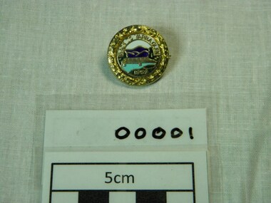
Badges, Stokes, c.1958
The 'Back to Yarra Glen' event was held on the Australia day weekend, 1959. Badge is circular with filigree work around the outer rim. The inner circle has a picture of the Yarra Glen bridge over the light blue river with the dark blue mountains in the background and green river bank in the foreground. There are green trees at each end of the gold bridge. The sky is white. On the green grass foreground is the date 1959. Above the mountains are the words 'Back to Yarra Glen'. The diameter is 2.5 centimetres. It is made of pressed metal, maybe brass, with gold colouring around the outer edge and back. On the front of the badge "Back to Yarra Glen" is across the top and "1959" on the bottom. "Stokes Melb" is on the back -
 Yarra Glen & District Historical Society
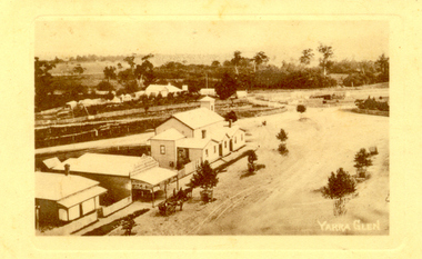
Sepia postcards, Yarra Glen
Sepia postcard with a view taken from the Grand Hotel tower looking down on Bell Street and the railway crossing at Yarra Glen very late 19th century. Young street trees on Bell Street. On east side of Bell Street are a dwelling, a general store, the Victoria Hall, a horse trough. Beyond the railway line is 'River View', the bridge over the river and the Yering flats.On back of postcard at the top "POST CARD". On the left hand side "THIS SPACE MAY BE USED FOR PRINTED OR WRITTEN MATTER”. On the right hand side "ONLY THE ADDRESS TO BE WRITTEN HERE”. In a box in the right hand corner "A HALF-PENNY STAMP TO BE PLACED HERE". Along the left hand margin "Ajax series. Printed in England". In blue biro is written "G. Keets Yarra Glen". Copy 2 has the following handwritten in black ink: "Yarra Glen. 28.8.11. Dear Maggie Hope you will like the Postcard. I also hope your head is better. On Saturday we took the kitten down to Dawborn's shop to catch some mice. When we got down there the kitten got away from us and we never got it till Monday morning. This is all the news this time. From your loving cousin, Walter.yarra glen, railway line, grand hotel, victoria hall, bell street, tree guards, railway crossing, river view, street trees, bell st, general store, horse trough -
 Port Melbourne Historical & Preservation Society
Photograph - Yarra River, Ron Laing, 1990s
Part of Ron Laing's collection of photographs recording Port Melbourne over a thirteen year period. Donated to the PMH&PS by the photographer. nb Includes photographs of Victoria Dock in the period of time after the commercial shipping had gone but before the start of the proposed high-rises. The Bolte Bridge which caused this closure of Victoria Dock, North and South Wharves is covered in photos 1319.01-.35.A set of 47 colour photogaphs of the Yarra River at various locations from the old Sandridge Railway Bridge westward to the power house at Newportyarra river, built environment, transport - shipping, ron laing -
 Monbulk RSL Sub Branch
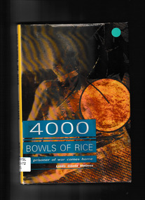
Book, Allen & Unwin, Four thousand bowls of rice : a prisoner of war comes home, 1993
Over 60,000 Australians and Americans captured by the Japanese during World War II toiled and died to build the Bridge over the River Kwai. Respected military historian Linda Goetz Holmes tells the story of one man's survival in Japanese labor camps during WWII. Amazing photographs, taken secretly by other prisoners, chronicle this dark history of Allied troops in the Pacific theatre of war.Index, bibliography, notes, ill, p.179.non-fictionOver 60,000 Australians and Americans captured by the Japanese during World War II toiled and died to build the Bridge over the River Kwai. Respected military historian Linda Goetz Holmes tells the story of one man's survival in Japanese labor camps during WWII. Amazing photographs, taken secretly by other prisoners, chronicle this dark history of Allied troops in the Pacific theatre of war.world war 1939 – 1945 - prisons and prisoners – australia, burma thailand railway -
 Benalla Art Gallery
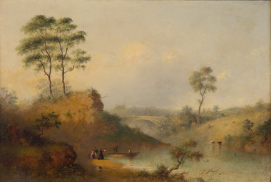
Painting, Henry BURN, Studley Park bridge over the Yarra, c. 1860
Born: Birmingham, Warwickshire, England 1807; Arrived: Melbourne, Victoria, Australia 1853; Died: Melbounre, Victoria, Australia 1884RomanticismGift of Beverley Brown, 2015Oil painting on board, depicting sparse rural landscape by a river and bridge.Gold brushed timber frame and decorative gesso inner corners. Recto: Not signed, not dated, not titledpainting, landscape, figures, boat, tree, bridge, river, animals, water -
Koorie Heritage Trust
Book, Blanks, Harvey, The Story of Yea : a 150 year history of the shire, 1973
Contents: Foreword; Preface; Prologue: The Dreamtime; Hume & Hovell's expedition; The coming of the overlanders; The first settlers; The Muddy Creek Aborigines; Early families & personalities; The settling of Highlands; Muddy Creek becomes Yea; Early teething troubles; The Road Board years; A bridge over troubled waters; From Mission to Church; The Shire - 1876 to 1900; Soldiers of the Queen; Into the New Century; How education came to Yea; Through Two World Wars; The Post-War Years; Appendices; Index.311 p., [16] p. of plates. : ill., maps. ; 22 cm.Contents: Foreword; Preface; Prologue: The Dreamtime; Hume & Hovell's expedition; The coming of the overlanders; The first settlers; The Muddy Creek Aborigines; Early families & personalities; The settling of Highlands; Muddy Creek becomes Yea; Early teething troubles; The Road Board years; A bridge over troubled waters; From Mission to Church; The Shire - 1876 to 1900; Soldiers of the Queen; Into the New Century; How education came to Yea; Through Two World Wars; The Post-War Years; Appendices; Index.other: yauung-illam-baluk tribe -- taungurong -- local history -- yea -- muddy creek -- goulburn river. -
 Kew Historical Society Inc
Photograph, J F C Farquhar, Railway Bridge Over the Yarra, 1891
... , including beside the Yarra River. Railway Bridge Over the Yarra ...At the beginning of the 1890s, the Kew businessman and Town Councillor, Henry Kellett, commissioned J.F.C. Farquhar to photograph scenes of Kew. These scenes included panoramas as well as pastoral scenes. The resulting set of twelve photographs was assembled in an album, Kew Where We Live, from which customers could select images for purchase.The preamble to the album describes that the photographs used the ‘argentic bromide’ process, now more commonly known as the gelatine silver process. This form of dry plate photography allowed for the negatives to be kept for weeks before processing, hence its value in landscape photography. The resulting images were considered to be finely grained and everlasting. Evidence of the success of Henry Kellett’s venture can be seen today, in that some of the photographs are held in national collections.It is believed that the Kew Historical Society’s copy of the Kellett album is unique and that the photographs in the book were the first copies taken from the original plates. It is the first and most important series of images produced about Kew. The individual images have proved essential in identifying buildings and places of heritage value in the district.Completed in November 1890, the railway viaduct (now the Chandler Highway Bridge) linked Kew and Fairfield. The viaduct is significant as the most substantial extant engineering remnant of the Outer Circle Railway Line. Opened in March 1891, the viaduct crossed the Yarra River in a single span, atop three supporting brick pillars. Following the closure of the railway line in 1927, and the construction of the Chandler Highway in 1930, the bridge was used for vehicular traffic. In 1891 when this panoramic photograph was taken, the grounds of what was then the Kew Lunatic Asylum extended down to the River and eastward beyond the viaduct. The landscape surrounding the Asylum was planted with traditional exotic trees such as Oaks, Pines and Cedars, and landmark trees from northern Australia such as the Hoop Pine. Remnant indigenous trees such as the River Red Gum, Yellow Box and Lightwood were scattered around the site, including beside the Yarra River.Railway Bridge Over the Yarrakew illustrated, kew where we live, photographic books, henry kellett, railway viaduct - - kew (vic) -
 Kew Historical Society Inc
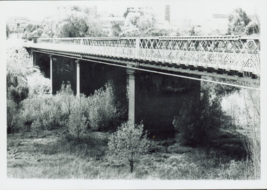
Photograph - Outer Circle Railway Viaduct
The heritage listed Fairfield Bridge was originally constructed for the Outer Circle Railway to bridge the Yarra River between East Kew and Fairfield stations. In the 1930s it was converted for vehicular traffic. In the 2010s a new concrete bridge was erected beside it to increase vehicular capacity.Print copy, enlarged from original snapshot, of the former railway viaduct crossing the Yarra and linking Kew and Fairfield. The original photo predates the conversion of the viaduct into the Chandler Highway Bridge in the 1930s, when the Bridge was adapted to carry vehicular traffic. The date on the reverse indicates the date of donation rather than the date on which the photograph was taken. CHANDLER HIGHWAY BRIDGE OVER RIVER / (ORIGINALLY PART OF OUTER CURCLE RAILWAY) / OCTOBER 1977railway viaduct -- kew (vic.), fairfield bridge, fairfield railway viaduct, outer circle railway, sir john monash -
 Kew Historical Society Inc
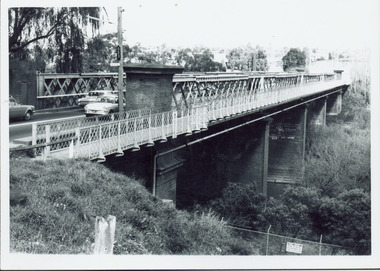
Photograph - Chandler Highway Bridge, 1977
The heritage listed Fairfield Bridge was originally constructed for the Outer Circle Railway to bridge the Yarra River between East Kew and Fairfield stations. In the 1930s it was converted for vehicular traffic. In the 2010s a new concrete bridge was erected beside it to increase vehicular capacity.Print copy of the Chandler Highway Bridge, [formerly the Fairfield Viaduct of the Outer Circle Railway] showing the original position of the walkway beside the bridge. The POV is from the Fairfield side looking towards Kew. CHANDLER HWY BRIDGE OVER YARRA / OCTOBER 1977 / ORIGINALLY BUILT FOR OUTER CIRCLE RWYchandler highway bridge, outer circle railway viaduct, bridges -- kew (vic.) -
 Kew Historical Society Inc
Photograph, Railway Viaduct, c.1900
Railway viaduct, Yarra River, linking Kew and Fairfield. Built by John Monash for the Outer Circle Railway. In 1930 converted into the Chandler Highway Bridge for vehicular traffic. Annotations on reverse: "KH-71. Outer Circle Railway Bridge (over Yarra) looking from Kew side to site of Paper Mills, Alphington.outer circle railway, railway viaduct (kew), john monash, chandler highway bridge -
 Kew Historical Society Inc
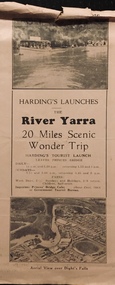
Flyer, Melbourne Ferries Pty Ltd, River Yarra: 20 Miles Scenic Wonder Trip
Bifold brochure including route map of the full 44 mile 'Wonder Trip' on pages 2 & 3. Photos used include an 'Aerial view over Dight's Falls', two ferries, and a 'Scene near Dight's Falls'.Flyer for Harding’s Launches on the River Yarra: 20 miles scenic wonder trip. Aerial view over Dight’s Falls on front. non-fictionBifold brochure including route map of the full 44 mile 'Wonder Trip' on pages 2 & 3. Photos used include an 'Aerial view over Dight's Falls', two ferries, and a 'Scene near Dight's Falls'.river yarra, melbourne ferries pty ltd, yarra river -- tourism, harding's cruises, christian-washfold collection -
 University of Melbourne, Burnley Campus Archives
Album - Black and white and colour prints, Freeway Construction, 1963-1972
(1) 14 photographs showing views of where the Freeway would be going through near Burnley Gardens. (2) 2 photographs of views of the Yarra River near Burnley Gardens. (3) Aerial photograph of construction of the Freeway near Burnley Gardens and Yarra Boulevard. (4) 8 colour photographs of construction work in and over the River Yarra near the railway bridge. "Brian Ward Freeway Construction" handwritten on cover of folder. Student Dux 1973.freeway, burnley gardens, yarra river, yarra boulevard, river yarra, brian ward -
Canterbury History Group
Book, Richard Broome, Remembering Melbourne 1850-1960, 2016
A book of over 700 black and white illustrations and photographs of early Melbourne scenes, mainly buildings, which have been demolished or significantly changed. The first half of the book concentrates on the CBD but includes public gardens and the Yarra River. The second half of the book looks at a number of the inner suburbs including Footscray.Large red covered book with black and white dust cover featuring panoramic view of Princes Bridge looking North. 366 pages : photographs, 1 map, portraits. Includes bibliographical references and indexnon-fictionA book of over 700 black and white illustrations and photographs of early Melbourne scenes, mainly buildings, which have been demolished or significantly changed. The first half of the book concentrates on the CBD but includes public gardens and the Yarra River. The second half of the book looks at a number of the inner suburbs including Footscray.historical buildings - melbourne, melbourne - history, canterbury - history -
 Melbourne Tram Museum
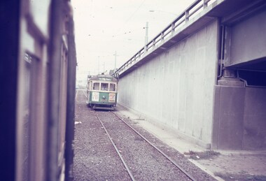
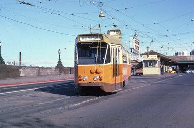
Slide, Keith Caldwell, Mar. 1968
Agfa colour slide, blue / white plastic mount, photo by Keith Caldwell of a view from a tram southbound in Kingsway section where the road bridge starts to rise to cross over the tram track and then the Yarra river. Tram 802, West Coburg - via William St, route 55 is in the view. Tram has adverts for Tolley's Brandy and ? in Essendon. 3/1968In ink "St K jct 3/68"trams, tramways, kingsway, bridges, route 55, west coburg, tram 802 -
 Melbourne Tram Museum
Postcard, Bartel Postcards, three photos of Melbourne scenes, early 1990's
... - Bartel Postcards: 1 - View of Melbourne over the Yarra River...: 1 - View of Melbourne over the Yarra River 2 - Princes ...Colour postcard 3 photo panels, blue border, divided back - Bartel Postcards: 1 - View of Melbourne over the Yarra River 2 - Princes Bridge 3 - B2 2013 in Bourke St, East Brunswick, Route 96 Back has space for name and address, stamp and a message and details of the postcard. Produced by Bartel Postcards possibly early 1990's Card No. BG318 Has "Melbourne Australia" along the bottom edge. Two copies held.trams, tramways, bourke st, mall, b class, tram 2013 -
 Melbourne Tram Museum
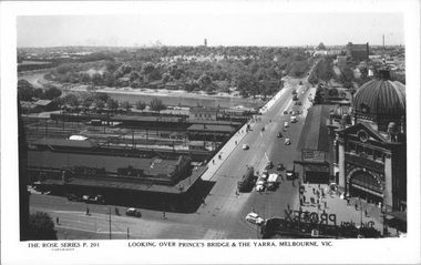
Postcard, Rose Stereograph Co, "Looking over Princes Bridge & The Yarra, Melbourne", c1941
Rose Series postcard No. P 201, titled "Looking over Princes Bridge & The Yarra, Melbourne" with a view including Princes Bridge Railway Station, Batman Ave. tram terminus with two trams, The Yarra River, the bridge, and the entrance to Flinders St station. The south west curve track from Swanston Street into Flinders Street is visible along with various Safety Zones at the tram stop.Yields information about St Kilda Road, Princes Bridge c1941Postcard - printed real photograph with Rose Stereograph Co. name on the rear. Two copies held.tramways, flinders st station, st kilda road, princes bridge station, princes bridge, yarra river, flinders st, trams -
 Melbourne Tram Museum
Postcard, Rose Stereograph Co, "Melbourne from the Air", early 1940s
Rose Series postcard No. P 622, titled ""Melbourne from the Air", Photo looking east over Melbourne with the Melbourne skyline, railway yards, St Kilda Road, Yarra River and Princes Bridge in the view. Three trams can be seen in the view in St Kilda Road. The building in the middle bottom of the photo is the recently completed Australian Provincial Assurance (APA) Assocation Limited Head Office on the south east corner of Collins and Queen Streets. This 1889 building was refaced and the tower added in 1928-1929. The adding of three additional floors to the Bank of Australasia building, 1875-1876, is well in hand 1929-1931 on the north west corner of Queen and Collins Streets. On the south east corner of the corner of Collins and Market Streets, the new Australian Mutual Provident (AMP) Society Head Office is reaching full height, also constructed 1929-1931. Yields information about an aerial view of Melbourne C1930Postcard - printed real photograph with Rose Stereograph Co. name on the rear.tramways, trams, aerial views, melbourne, collins st. -
 Melbourne Tram Museum
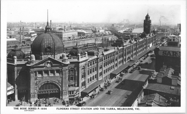
Postcard, Rose Stereograph Co, "Flinders Street Station and the Yarra, Melbourne", late 1920s
Rose Series postcard No. P 1666, titled "Flinders Street Station and the Yarra, Melbourne". This photo is looking southwest from St Paul's Cathedral over the station building along the Yarra river. The St Kilda/Port Melbourne and Queens bridge are in view, but not the Spencer St bridge which was built during the late 1920s. The AW Allen's Limited Confectionary Factory constructed in 1923-24 on Riverside Avenue dominates the landscape on the south side of the river directly behind the dome of the Flinders Street railways station. One very long set of horse-drawn carts can be seen alongside the center entrance to the railway station building in Flinders Street.Yields information about an aerial view of Melbourne late 1920sPostcard - printed real photograph with Rose Stereograph Co. name on the rear.tramways, trams, flinders st station, yarra river, bridges, railways, flinders st -
 Melbourne Tram Museum
Slide - set of 3, Chris Jacobson, Z class tram No 1, May 1975
... Elgar Road. 2 - In Wallen Road, just over the Yarra River Bridge... - In Wallen Road, just over the Yarra River Bridge at Hawthorn 3 ...Set of three Colour slides of a new Z class, No. 1 tram dated May 1975. The tram entered service on 5/5/1975 - see reference. 1 - Leaving Batman Ave terminus, route 70 for Wattle Park Elgar Road. 2 - In Wallen Road, just over the Yarra River Bridge at Hawthorn 3 - Swan St - Batman Ave intersection with the Olympic Swimming pool in the background along with a W class running a route 77.Yields information about Z class 1 and Batman Ave terminus.Set of 3 Kodachrome colour slides, cardboard mount.All have "Chris" in ink on the rear.tramways, z class, new tram, tram 1, batman ave, route 70, wallen road